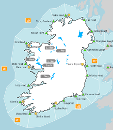
Lochanna in Éirinn - Réamhaisnéis 10 lá
Inland lakes forecast issued at: 0300 Wednesday 21 October 2026
Meteorological Situation at 0300
Ireland lies in a cyclonic variable airflow generated by a complex low pressure system centred west of Iceland, with a secondary depression of 994hPa centred to the northwest of Ireland. Associated active weather fronts will clear into the Irish Sea this morning.
Forecast for Lough Derg until nightfall today:
Wind:
Northwest to west force 4 or 5 and gusty for a time.
Weather:
Showers.
Visibility:
Mostly good.
Winds Overnight:
Thundery rain in the evening and early night. Light to moderate cyclonic variable mainly westerly winds.
Outlook:
Light to moderate southeast winds, becoming cyclonic variable mainly northeast during the evening and increasing fresh to strong and gusty. Mostly fair with very heavy rain later.
Forecast for Lough Ree until nightfall today:
Wind:
Northwest to west force 4 or 5 and gusty for a time.
Weather:
Showers.
Visibility:
Mostly good.
Winds Overnight:
Thundery rain in the evening and early night. Light to moderate cyclonic variable mainly westerly winds.
Outlook:
Light to moderate southeast winds, becoming cyclonic variable mainly northeast during the evening and increasing fresh to strong and gusty. Mostly fair with very heavy rain later.
Forecast for Lough Corrib and Lough Mask until nightfall today:
Wind:
Northwest to west force 4 or 5 and gusty for a time.
Weather:
Showers.
Visibility:
Mostly good.
Winds Overnight:
Thundery rain in the evening and early night. Light to moderate cyclonic variable mainly westerly winds.
Outlook:
Light to moderate southeast winds, becoming cyclonic variable mainly northeast during the evening and increasing fresh to strong and gusty. Mostly fair with very heavy rain later.
Forecast for Lough Key and Lough Allen until nightfall today:
Wind:
Northwest to west force 4 or 5 and gusty for a time.
Weather:
Rain at first. Showers imminent.
Visibility:
Mostly good.
Winds Overnight:
Thundery rain in the evening and early night. Light to moderate cyclonic variable mainly westerly winds.
Outlook:
Light to moderate southeast winds, becoming cyclonic variable mainly northeast during the evening. Mostly fair with rain later.