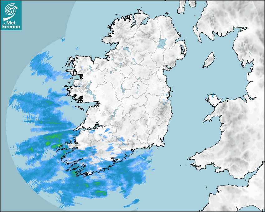

Latest Rainfall Radar showing live precipitation and the last 90 minutes precipitation over Ireland, updated every 5 minutes. Precipitation can be rain, hail or snow. Accumulations can refer to rainfall only.
Lightning strikes, when they occur, are displayed as a cross. Initially, they are red but change to orange and then yellow after a period, then disappear © Met Office ATDNet.
Ground Clutter may appear (South Co. Dublin), bright bands and spokes may also be present in images. They are artefacts (false echoes) of rainfall radar systems and should be ignored. Further information on Radar here
Met Éireann forecasters manually produce the weather icons for midday and midnight to reflect the predicted major weather type for these times.
The rainfall forecast is direct model output from Numerical Weather Prediction models but is a guideline only. Rain refers to precipitation, which can be rain, sleet or snow. It forecasts how much rain will fall (in mm) hourly during the previous hour (accumulations), then in 3 hourly and finally 6 hourly accumulations up to 7 days. This service is based on data and products of the HARMONIE-AROME and the European Centre for Medium-range Weather Forecasts (ECMWF) models.
The wind is direct model output from Numerical Weather Prediction models but is a guideline only. It forecasts the strength of the wind (in knots and km/h) at 10m for the top of each hour, in hourly, then 3 hourly and finally 6 hourly intervals up to 7 days. The wind arrow tip points in the direction the wind is blowing and the tail length indicates wind strength. However, in the text forecast below, it is described as where it is blowing from. This service is based on data and products of the HARMONIE-AROME and the European Centre for Medium-range Weather Forecasts (ECMWF) models.
The temperature is direct model output from Numerical Weather Prediction models but is a guideline only. It forecasts air temperature on land and over sea in °C for the top of each hour, 3 hourly and finally 6 hourly intervals up to 7 days. Minus zero (-0) indicates values between 0 to -0.5°C. This service is based on data and products of the HARMONIE-AROME and the European Centre for Medium-range Weather Forecasts (ECMWF) models.
The Mean Sea Level Pressure (MSLP) is direct model output from Numerical Weather Prediction models but is a guideline only. It forecasts the MSLP in hecto Pascals (hPa) for the top of that hour initially in 3 hourly intervals, then 6 hourly. This service is based on data and products of the HARMONIE-AROME and the European Centre for Medium-range Weather Forecasts (ECMWF) models.
National Forecast
01 August 2026 23:30
Tonight
Dry for most tonight with cloud continuing to thicken from the southwest with patchy rain and drizzle developing in the southwest and west. Lowest temperatures of 8 to 14 degrees, coolest in the north, with areas of mist and fog forming in light variable breezes.
Tomorrow
Tomorrow, Sunday, will be cloudy with outbreaks of rain and drizzle continuing to extend northeastwards through the day, heaviest and most persistent in the southwest and west. However, parts of the southeast and east may remain mostly dry. Highest temperatures of 14 to 20 degrees, coolest in the west, in mostly light easterly breezes. Mist patches also.
Met News

02nd July 2026
Climate Statement for June 2026
Warm and wet. Heat dome brought heatwaves and exce... more

26th June 2026
139th Anniversary of Ireland’s hottest day
139th Anniversary of Ireland’s hottest day – 3... more

22nd June 2026
A look back at the summer of 1976
The summer of 1976 is remembered in Ireland and th... more

08th June 2026
Met Éireann and UCC launch new resources for teaching climate change in schools
A new graphic novel and suite of educational resou... more