Marine Forecasts and Reports can be accessed via the links below:
- Sea Area Forecast
- Buoys
- Lakes in Ireland – 10 day forecast
- Islands & Beaches – 10 day forecast
- Sea Conditions
- Ireland Wind Barbs
- Sea Crossings
- Wave Height Forecast
- Coastal Reports
- Beaufort Scale
The Sea Area Forecast and marine warnings issued by Met Éireann covers Irish Coastal Waters out to 30 nautical miles, and also includes the Irish Sea.
The Marine Warning zones are indicated on our Marine Weather Services map below.
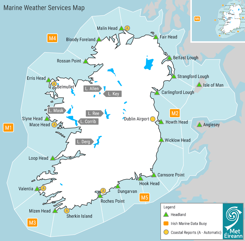
Marine Weather Services map
The Sea Area Forecast
The Sea Area Forecast for 24-hours ahead with an outlook for the following 24-hours is issued by the duty forecaster in Met Éireann 4 times a day; at midnight, 6am, noon and 6pm with relevant Small Craft Warnings/Gales Warnings for that period.
The Meteorological Situation at 09:00UTC (15:00, 21:00, 03:00)
A description of the meteorological situation over Ireland at the stated time and of adjacent weather systems, e.g. depressions, anticyclones or frontal troughs, which are expected to have an influence on the forecast areas during the following 24 hours. Explanation of some terms used here are:-
- Imminent: within 6 hours
- Soon: between 6 and 12 hours
- Later: between 12 and 24 hours
The speed of movement of pressure and frontal systems is described as follows:-
- Slowly: up to 15 knots
- Steadily: 15 to 25 knots
- Rather quickly: 25 to 35 knots
- Rapidly: 35 to 45 knots
- Very Rapidly: greater than 45knots.
The general forecast follows giving wind, weather and visibility for all coastal waters and the Irish Sea.
Wind:
The wind strength is given in Beaufort Force and wind direction using the 16-point compass.
Weather:
The following are some terms used in the Forecast and coastal reports:-
- Fine: Dry, mainly sunny day. Clear after dark.
- Fair: Dry, good sunny or clear spells(cloud no more than 3 – 5 okta of medium or low cloud or 6 – 8 okta of high cloud).
- Cloudy: 6 – 8 okta of low or medium cloud.
- Mist: Visibility restricted by water droplets.
- Haze: Visibility restricted by dust or smoke.
Other terms such as rain or hail shower are self explanatory.
Visibility:
descriptions of visibility mean the following:-
- Good: more than 5 nautical miles (9km)
- Moderate: 2 – 5 nm (4 – 9 km)
- Poor: 0.5 to 2 nm (4km)
- Fog: less than 0.5 nm (1,000m)
Swell Warnings:
When significant swell height of greater than 4 metres is expected.
Outlook:
A brief outlook is given for the 24 hours following the period covered by the forecast.
Coastal Reports
(from a selection of the following stations):
Malin Head
Dublin Airport
Roches Point Automatic
Sherkin Island
Mace Head
Valentia
Belmullet
M2 buoy
M3 buoy
M4 buoy
M5 buoy
M6 buoy
The coastal reports include:
(a) wind direction on the 16 point compass and speed in knots
(b) weather
(c) visibility in nautical miles and tenths of,
(d) pressure in hectopascals (millibars)
(e) pressure tendency, which describes the change in pressure over the past 3 hours, according to this scale:
- 0.0 – 0.4hPa = steady
- 0.5 – 1.9hPa = rising/falling slowly
- 2.0 – 3.4 hPa = rising/ falling
- 3.5 – 5.9 hPa = rising or falling rapidly
- 6.0hPa or greater = rising or falling very rapidly
Sea Crossings
Wave Heights / State of Sea
The wave height is the vertical distance between the crest and the preceding or following trough. The table below gives a description of the wave system associated with a range of Significant Wave heights. The Significant wave height is defined as the average height of the highest one-third of the waves. (It is very close to the value of wave height given when making visual observations of wave height.)
| Sea State (Descriptive) | Significant Wave Height (in metres) |
|---|---|
| Calm | 0 – 0.1 |
| Smooth(Wavelets) | 0.1 – 0.5 |
| Slight | 0.5 -1.25 |
| Moderate | 1.25 – 2.5 |
| Rough | 2.5 – 4.0 |
| Very rough | 4.0 – 6.0 |
| High | 6.0 – 9.0 |
| Very High | 9.0 – 14.0 |
| Phenomenal | Over 14.0 |
Individual waves in the wave train will have heights in excess of the significant height. The highest wave of all will have a height about twice the significant height.
Gale Warnings
Gale warnings are issued by Met Éireann for Irish coastal waters, which are regarded as extending 30 miles out from the coastline, and the Irish Sea or part thereof.

Yellow warning
Gale Warnings are issued if winds of Beaufort Force 8 are expected, a Status Yellow Marine (Gale) warning will be issued. Strong Gale Warnings are issued if winds of Beaufort Force 9 or frequent gusts of at least 52 knots are expected.

Orange warning
Storm Force Warnings are issued if Beaufort Force 10 or frequent gusts of at least 61 knots are expected, a Status Orange Marine (Gale) warning will be issued.

Red warning
Violent Storm Force Warnings are issued if Beaufort Force 11 or frequent gusts of at least 69 knots are expected, a Status Red Marine (Gale) warning will be issued. Hurricane Force Warnings are issued if winds of greater than 64 knots are expected.
Small Craft Warnings
Small craft warning
Small Craft Warnings are issued if winds of Beaufort Force 6 (min. mean of 22 knots) are expected up to 10 Nautical miles offshore.
Media and Commercial Availability of Sea Area Forecasts
The Sea Area Forecast for 24-hours ahead is issued by the duty forecaster in Met Éireann 4 times a day; at midnight, 6am, noon and 6pm with relevant Small Craft Warnings/Gales Warnings for that period. These gale warnings are distributed to RTÉ to be broadcast with the short weather forecast after each News bulletin on the hour. They are also sent to the coastguard for broadcasting on Marine VHF Radio Ch16. The SAF is broadcast live on RTÉ Radio 1 from the Met Éireann studio at five to midnight and two minutes past 6am daily.
As part of our warnings expansion and developments, Met Éireann will now be issuing Small Craft Warnings and Gale warnings for the period 24-hours to 54-hours ahead. These will be displayed on the Warnings page using the new 3-Tab display system. Please subscribe to receive push notifications of these Marine warnings through the Met Éireann App.
The Irish Coast Guard (ICG) Coast Radio Stations.
ICG Coast Radio Stations make a prior announcement of weather forecasts on Marine VHF Radio Ch16 and then broadcast the forecast on the named relevant VHF Radio working channel. Sea Area Forecasts are broadcast every 3 hours beginning at 0103 local time.
i.e. broadcast times are:- 0103, 0403, 0703, 1003, 1303, 1606, 1903, 2203 local time.
Gale Warning broadcasts are also preceded by an announcement on Marine VHF Ch16. They are broadcast on receipt and are repeated at the next one of the following times:- 0033, 0633, 1233 and 1833 local time.
Web
The latest Sea Area Forecast, Small Craft Warning and Gale Warnings (if any) are available on our Warnings page.
Sea Surface Temperature Forecast
The Sea Surface Temperature forecast map is available here for 7 days ahead.