Find out the hourly forecast for any place in Ireland up to 10 days ahead – on www.met.ie and on our app
When you visit our website for the first time, you may be asked to allow the website to access your location- this optional feature automatically generates a localised weather forecast. Your geo-location information is not stored by us or sent elsewhere. Further information in the Met.ie Privacy statement.
We designed the homepage to combine our most popular services with a tailored, comprehensive weather forecast for any place in Ireland! This can be viewed all on the homepage:
- Rainfall Radar/Weather Forecast map
- Detailed Weather Forecast for a location on a graph
- National and Regional text Forecast
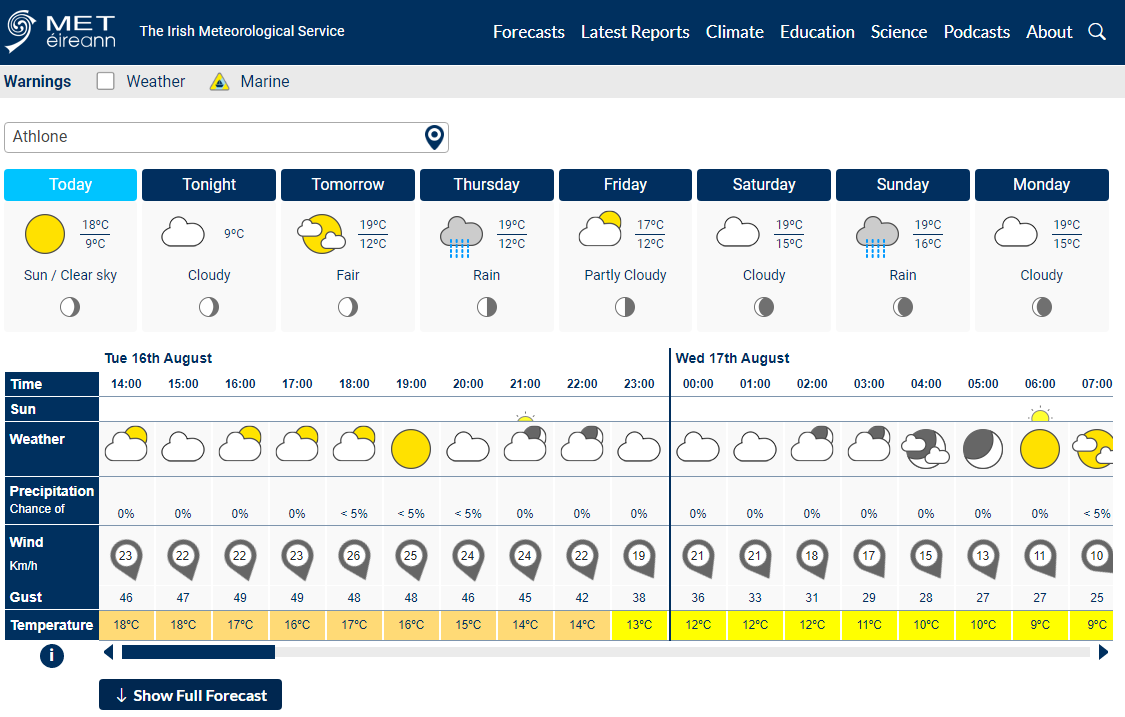
At the top of our homepage is the hourly 10-day weather forecast for a location. To see the hourly Precipitation forecast and other forecasts, click Show Full Forecast. There is some information on the hourly forecast in the ‘i’ button and more in the Forecast Explained page.
To get this forecast for a location you can either click on the location search box and type in the name of the place you would like a forecast for and select one of the suggestions, or click on a required area on the map below it.
This will update the hourly forecast to that location within a couple of seconds and also change the Regional forecast text to that province. The search box will also store your last 3 searched locations – click on the search box and scroll down to view them, you can select then for ease of return. Each time the map is clicked, a new detailed forecast is generated with the location displayed.
The daily outlook above the hourly forecast displays the weather symbol type at 1200 in Wintertime and 1300 in Summertime in line with IST. It shows the maximum/minimum temperature forecast for that location on those days (0900-0900 UTC) and the moon phase symbol.
![]()
You can find the homepage again from any other page of the website by clicking on the Met Éireann logo on the top left.
Weather Map
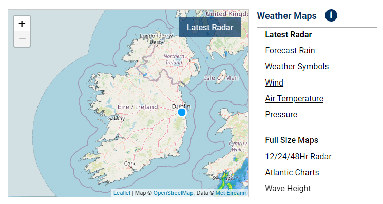
The map combines the following separate Weather Maps:
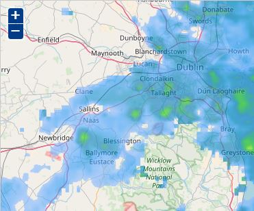
- Rainfall Radar: now in 5-minute intervals going back 90 minutes
- Forecast Overview: a quick snapshot from our forecasters of what weather to expect for the next five days at midday and midnight
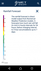
- Computer-generated detailed forecasts for Rainfall, Wind, Temperature and Pressure. These forecasts run in hourly intervals for the next 2 days, then 3 and 6 hourly up to 7 days into the future. There are text legends and unit conversions u
The default map is the Rainfall Radar, it shows the most recent radar image first. Press the Play button to view the last 90 minutes of rainfall images. This radar plays in 5-minute intervals showing greater recent rainfall information. This radar also shows where lightning strikes have occurred. A Rainfall Radar in 15-minute intervals over a longer time period is available here the Latest Reports menu. The map used across our website is provided by Open Street Maps. For copyright reasons, we cannot alter any names or lines on it.
![]()
To the right of the map, you can select the other weather forecast maps by clicking on the one you want- Forecast Overview (symbols), Rainfall Forecast (7 days ahead), Wind, Temperature, Pressure and other maps are available on another page. Then click the Play button at the bottom of each map to ‘play’ the weather forecast forward. You can click anywhere on the time bar to view other time images, or you can pull it to the left and right, then click play. The first two days of the forecast move in hourly steps, then the forecast switches to three hourly and finally to six hourly intervals, displaying either an accumulation (rainfall) during that interval, or the weather at the top of that hour. Each weather image is forecasted for that time, more details are provided in the legend description below each map.
A feature of the new website is that all the maps (apart from Pressure) can be zoomed in and out- and can be played at other zoom levels. You can do this either by double-clicking on the map or by using the +/- buttons on the top left-hand corner, then use the mouse to drag it to the location you want. This allows you to play the weather images passing over your nearest towns.
Please note: the map does not update itself as time passes- you must refresh the page to view the most up to date weather images.
Larger versions of the maps are available on the Full Size Maps option, and here. If the Weather Map or other charts are blank on your website browser, you may need to clear the cache/data for met.ie on your browser to view it again, see our FAQ for suggested methods for doing this .
Other New Features
There are many other new features of our website which may be of interest:
- County-based weather warning map
- Full daily data report for each weather station for today and yesterday with an option to download the data
- Buoy map
![]() You can click on the menu items to view other services available.
You can click on the menu items to view other services available.
The Atlantic chart maps are now available in the Forecast menu here!
New Met Éireann App
If you have a smartphone or tablet we recommend you use our free Met Éireann app, this is available to download from your Android or iOS app store. There are links at the bottom of this page.
The app has a more condensed version of the main website but includes all the same weather map images as the website homepage. Smartphone Users: the website homepage weather map is best viewed on the app.
When you open the app for the first time, it will ask for permission to access your location. This is an optional feature allowing our app access to your devices’ GPS location to generate a weather forecast by Met Éireann for that location. The location information is retrieved from the Google database and send to our forecast API to generate a weather forecast for that location. Your information will not be sent elsewhere. The privacy statement detailing this process can be found in the app menu. To use this feature, Location Services needs to be turned on in your devices’ Settings. If you do not wish to use this feature, you can still get a forecast for a location using the magnifier at the top right- see the section below for more details. This will give you a forecast for that location if it is on our list. If the location is not on our list and you would like it added in, please contact us at digital.queries@met.ie with the location name request. The location list is generally restricted to town/village/townland/tourist location/sports arenas.
If the app cannot locate you, it will revert to Dublin.
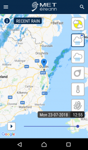
The map shows an overview of your area and the most recent Rainfall Radar image from the last 5 minutes. Tap this map to view our Rainfall Radar and Weather Forecast maps.
This sign > is a signal to tap for further information.
In the app homepage you can view the following:
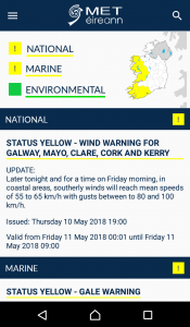
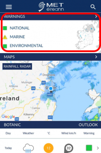
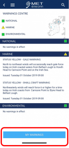
- Weather Warnings: View current weather warning map and read details of any National, Marine, Environmental warnings or Advisories.
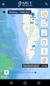
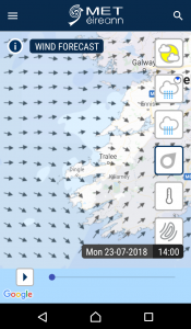
- Map: Your location will be centred on the map showing the most recent Rainfall Radar image. Tap this map to see the same weather maps as on the website homepage. To the right of the map are 6 square symbols, tap each to view the radar and other weather forecast maps. The title will change for each map. Play, pinch and zoom in or out (to view the whole country) or move the map around and play it in a zoomed in mode. You can move the slider over and back to view different day/times. Tap the ‘i’ icon for further information about each map.
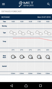
- Outlook: The Daily weather section shows the weather at 1200 in Wintertime, 1300 in Summertime in line with IST. Tap each day to show the hourly weather forecast breakdown for 7 days ahead, tailored to your location or another requested location. Tapping the weather symbol brings up the text description at the bottom of the screen.
- Current Conditions: View current conditions from the nearest full-suite weather station for that location.
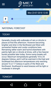
- Text Weather Forecast: Read the National and Regional weather forecast and all Marine and Farming forecasts. If you want to read a different Regional Forecast, tap the magnifier and enter a location in that province. This update the app homepage to that area- map, outlook and Regional Forecast.

Tap this menu icon for quick access to Home or other sections. Or use the back button to return to Home.
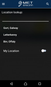
To look up the forecast for another location tap the magnifier in the top right. This will update the homepage map, outlook, current conditions and regional weather forecast to the new province. To change back to your location, tap the magnifier and turn on the Use My Location on/off slider. A list of previous searches will stay, you can tap them to get a forecast for that location again- no need to retype.
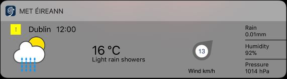
There is also a handy widget available on your device widgets list. This will show the latest readings from your nearest full-suite weather station.
Popular pages such as the Atlantic charts, Satellite images and weather station reports can be viewed fully on a device web browser.
Here are some images of the information available by tapping sections on the app homepage:
Weather Warning Push Notifications
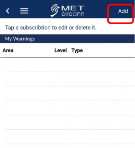
In the updated version of the Met Éireann app, you can set up subscriptions to receive Push Notifications of all Weather Warnings and Advisories. This can be set up in the Warnings section, or My Warnings on the app menu. You can choose to receive every warning for every county or just a single warning type for a single county, or any combination of types, levels and counties.
The current app version is available in your App store.
If you have any further queries on the website or apps please email digital.queries@met.ie
The Privacy Statement for www.met.ie is located here