The very warm, dry and settled spell will continue over Ireland this week with high pressure continuing to dominate our weather. Daytime temperatures will widely be in the 20s, possibly reaching 30 degrees in some places. It will also remain warm and humid at night with temperatures often not falling below 15 degrees.
Figure 1: Airmass Analysis Chart 00UTC Monday 13th July
An area of high pressure is currently centred near the Faroe Islands, maintaining the dry, settled and largely sunny conditions across Ireland. The easterly airflow generated by this anticyclone is bringing a very warm, humid airmass to Ireland from continental Europe. Temperatures will be highest in the west, south and midlands at first this week as a result, with the easterly airflow resulting in slightly cooler temperatures near eastern coasts.
Daily Maximum Temperatures, July 14th-18th
Later this week, a weak area of low pressure to the south will introduce some instability across Ireland. While high pressure will remain dominant, this instability will bring the potential for some heavy showers or thunderstorms in parts of the south and west on Wednesday and Thursday.
Figure 2: ECMWF forecast mean sea level pressure and precipitation for 1800UTC Wednesday 15th July
Current indications suggest that high pressure will remain close to Ireland through Friday and the weekend, with the dry conditions persisting. However, a northerly airflow will become established, which will bring slightly lower temperatures to the north and northwest with daytime temperatures here generally in the high teens. Further south, the temperatures will remain in the low to mid-twenties.
Figure 3: ECMWF forecast mean sea level pressure and wet bulb potential temperatures at 850hPa for 0600UTC Saturday 18th July
Impacts
The very warm or hot weather may produce some uncomfortable conditions, particularly at night.
With widespread sunshine, UV levels will be high or very high, so please follow the guidance from the HSE’s SunSmart campaign,
Heat stress may pose an issue. Useful guidance from the HSE can be found here: https://www2.hse.ie/conditions/heat-exhaustion-heatstroke/
There will be an increase in people heading to beaches, lakes and waterways to cool down in the heat, so please take precautions from Water Safety Ireland to stay safe, watersafety.ie.
Public Health is a significant consideration during high-temperature events, and the public is advised to:
Stay in the shade.
Avoid going out or partaking in strenuous activities during the hottest part of the day.
Drink plenty of fluids.
Apply UVA and UVB sunscreen to skin that is not covered, factor 30+ for adults and 50+ for children.
The Health Services Executive (HSE) have specific and comprehensive advice on staying safe in hot weather, and this can be accessed at the following address: https://healthservice.hse.ie/staff/procedures-guidelines/staying-safe-in-hot-weather/
Water Safety
If you’re planning an activity in or on the water, remember:
Swim at a lifeguarded waterway if possible.
Swim within your depth, stay within your depth.
Avoid entering the water in locks, marinas and harbours where hidden hazards may be present.
Supervise children: Never leave them unattended near water.
Avoid alcohol before swimming, operating watercraft or being near water, as it impairs judgment, coordination, and reaction time.
Be aware that cold water temperatures can also cause cold water shock, increasing the risk of drowning.
Pay attention to all water safety signs and warnings and carry a means of calling for help.
Check tides and updated weather warnings.
Always wear a correctly fitting serviced lifejacket or buoyancy aid when boating or participating in water sports.
Let others know where you are going and when you expect to return.
For more water safety information, contact www.watersafety.ie.
Fire Safety
The High Temperatures will likely bring an increase in outdoor activities, and the public is reminded that everybody has a part to play in protecting our unique rural landscapes, communities, habitats and forest resources from the threats posed by wildfire. If you are out and about enjoying our countryside and forests this summer, please help to reduce the risks of fire by keeping the following in mind:
Do not light fires in or near woodland. Use only designated barbecue points where available. Thoroughly soak BBQ embers after use and make sure that they are extinguished completely.
Do not block forest entrances or roads when parking – access may be required by the fire service or forestry personnel in the event of an emergency.
If you see a fire, report it immediately to the emergency services – Dial 999 or 112.
Report any illegal and suspicious activity to the Gardai. Note that the burning of growing vegetation on uncultivated land between 1 March and 31 August each year is prohibited by law.
Do not approach fires or attempt to extinguish fires yourself. Wildfires can be extremely dangerous and can rapidly change direction and behaviour.
Further advice is available from the Department of Agriculture, Food and the Marine at https://www.gov.ie/en/department-of-agriculture-food-and-the-marine/publications/fire-management/
…………………………………………………..
Issued 7/7/26
Ireland will see temperatures climbing through the week with expected values in the high 20s and possibly reaching 30 degrees in some places this weekend. It will also be warm and humid at night with temperatures likely to remain above 15 degrees.
Meteorological Situation
Figure 1 – 06Z Synoptic Analysis
A ridge of high pressure is currently situated over Ireland, extending from an anticyclone over the Azores, which is bringing dry, settled and sunny conditions to much of the country. However, conditions will stay cloudier in the north and west at first due to a slow-moving frontal zone lingering over the northwest. From Friday, high pressure is expected to shift to the north of Ireland, with support from the upper air pattern. This will allow temperatures to increase, and the sunshine to become more widespread.
Figure 2 – ECMWF forecast mean sea level pressure and wet bulb potential temperatures at 850hPa for Saturday 11th July at 1pm.
At first the airflow is southwesterly, and with the cloudier conditions in the northwest, the warmest temperatures are expected in the southeast. As high pressure shifts to the north on Friday, the airflow will become northeasterly which will see the warmest temperatures then in the south and southwest.
Figure 3: Daily Maximum Temperatures, July 7th-16th
Impacts
The very warm or hot weather may produce some uncomfortable conditions, particularly at night.
With widespread sunshine, UV levels will be high or very high, so please follow the guidance from the HSE’s SunSmart campaign,
There will be an increase in people heading to beaches, lakes and waterways to cool down in the heat, so please take precautions from Water Safety Ireland to stay safe, watersafety.ie.
The High Temperatures will likely bring an increase in outdoor activities, and the public is reminded that everybody has a part to play in protecting our unique rural landscapes, communities, habitats and forest resources from the threats posed by wildfire. If you are out and about enjoying our countryside and forests this summer, please help to reduce the risks of fire by keeping the following in mind:
Do not light fires in or near woodland. Use only designated barbecue points where available. Thoroughly soak BBQ embers after use and make sure that they are extinguished completely.
Do not block forest entrances or roads when parking – access may be required by the fire service or forestry personnel in the event of an emergency.
If you see a fire, report it immediately to the emergency services – Dial 999 or 112.
Report any illegal and suspicious activity to the Gardai. Note that the burning of growing vegetation on uncultivated land between 1 March and 31 August each year is prohibited by law.
Do not approach fires or attempt to extinguish fires yourself. Wildfires can be extremely dangerous and can rapidly change direction and behaviour.
A weak warm front tracking along the northwest coast of Ireland, closely followed by a cold front overnight, will likely trigger thunderstorms today (Thursday) and tomorrow (Friday). To develop, a thunderstorm needs moisture, instability and a lifting mechanism. While the moisture is coming from the exceptionally warm and humid conditions we’ve observed over the last number of days, both the instability and potential lift is being derived by the weather fronts. Should this trigger be enacted, it is likely that parts of the northwest and west will experience extreme thunderstorm activity today and tonight. Other areas may see somewhat less severe thunderstorm activity tomorrow.
Heavy and intense rainfall associated with thunderstorms may lead to localised flooding in affected areas. Other possible impacts include; lightning damage, hail, hazardous driving conditions and very gusty winds.
Thursday June 25th
There is significant CAPE activity expected on Thursday, resulting in lightning strikes and thunderstorms.
Figure 2 – DINI EPS Lightning (strikes per hour) – Thursday 25th June – 8pm
Figure 2 illustrates the uncertainty in the location of the potential lightning strikes Thursday, as shown by our local weather model (DINI).
CAPE (Convective Available Potential Energy) indices, give us an indication on the amount of energy available in the upper air to fuel the thunderstorms (should the trigger be met). As a result of the intense heating, CAPE values are expected to exceed >3000 J/Kg in some areas. These values are exceptional for Ireland and are often associated with the extreme thunderstorm activity observed on continental Europe.
Figure 3 – DINI EPS CAPE Probability – Thursday 25th June – 8pm
Friday June 26th
For tomorrow, Friday, there is significant CAPE around, albeit not as extreme as today. However, in contrast, the probability signal for lightning strikes is greater than today, meaning there is more confidence in the occurrence of significant thunderstorm activity.
Figure 4 – DINI EPS Lightning (strikes per hour) – Friday 26th June – 3pm
Figure 4 illustrates the uncertainty in the location of the potential lightning strikes Friday, as shown by our local weather model (DINI).
Figure 5 – DINI EPS CAPE Probability – Friday 26th June – 3pm
There is some uncertainty in the model forecast on where and when exactly the thunderstorms will occur, or if they will remain offshore. However, should they occur, their intensity is expected to be quite impactful. To reflect this a status yellow thunderstorm warning has been issued for Connacht and Donegal and will be in effect from 3pm today until 6pm Friday.
In summary, while today and tonight there is a lower chance of extremely severe thunderstorms developing in the west and northwest, there is a higher chance of somewhat less severe activity tomorrow over a broader area of Ireland.
Although many areas may not be affected, any thunderstorms that do develop could produce dangerous lightning, torrential rainfall, localised flash flooding, large hail, and damaging wind gusts. Conditions can change rapidly.
Heavy and intense rainfall associated with thunderstorms may lead to localised flooding in affected areas.
Localised flooding is possible this evening (Thursday 25th) and tomorrow across Connacht, Ulster, and parts of Leinster and Munster. Intense downpours may result in the rapid flooding of roads, properties and low-lying areas, and low-lying little warning.
Current forecast guidance indicates that the northern and western half of the country is most likely to be affected, however, thunderstorms can be highly localised and difficult to predict the exact location. Many areas may remain dry, while nearby locations could experience very heavy rainfall and flooding.
Please follow the up-to-date safety advice in your area, and:
Follow Met Éireann forecasts and weather warnings.
If you hear thunder, move indoors immediately.
If heavy rain begins, avoid driving unless necessary.
If roads become flooded, turn around and find another route.
Never drive, walk or cycle through floodwater. Heavy rainfall can cause dangerous flash flooding with little warning.
If lightning develops, stop outdoor sports including swimming, and seek shelter.
If hail develops, seek shelter, hail can be damaging to cars, structures, trees, and crops.
Stay hydrated and avoid strenuous activity during the hottest part of the day.
Check on vulnerable family members, neighbours and friends.
Stay weather aware and be prepared to act if conditions deteriorate in your area.
————————————————————————————————————-
Headline
Ireland will see temperatures climbing through the week with expected values in the high 20s or even rising to 30 degrees or higher by Thursday. It will also be extremely mild and humid which will make for some uncomfortable conditions, especially at night, with temperatures likely to remain above 15 degrees.
The high temperatures will also increase the risk of thunderstorms developing, and currently Thursday is expected to see some in the northwest.
Meteorological Situation
Much of Europe is under a heatwave which will cause temperatures of 40 degrees or higher. A plume of extremely hot air from Europe will move towards Ireland bringing it with hot and humid conditions. The heat will build through the week, with temperatures expected to reach the high twenties and even the low thirties by Thursday. It will become very humid and dewpoint temperatures which give a measure of how humid the air will be could hit the mid-twenties on Thursday afternoon (Figure 1), making for some very uncomfortable conditions.
Figure 1 – Dewpoint temperatures Thursday 25th June 4pm
If we look at the wet bulb potential temperature, values in the high teens or low twenties are expected on Thursday. The wet bulb potential temperature gives an indication of how the atmosphere will impact us in terms of heat stress. Figures like this point to uncomfortable conditions on Thursday.
Maximum temperatures on Thursday are likely to reach 30 degrees or higher in parts of the country (Figure 3). These figures may creep even higher. Once our high-resolution forecast model comes into range for Thursday we will have more confidence for the maximum temperatures.
Figure 3 – Maximum Temperatures Thursday 25th June
The hot weather will break on Friday with cooler conditions arriving and temperatures falling back to the low twenties.
Impacts
The hot weather will produce impacts such as uncomfortable conditions during the day and especially by night.
The hot weather will also mean people will head to our rivers, sea and lakes we urge you to take precautions from Water Safety Ireland.
Finally the hot conditions will mean high UV values, please follow the guidance from the HSE’s SunSmart campaign: https://www.met.ie/uv-index
Public Safety Advice
Public Health is a significant consideration during high-temperature events, and the public is advised to
Stay in the shade
Avoid going out or partaking in strenuous activities during the hottest part of the day
Drink plenty of fluids
Apply UVA and UVB sunscreen to skin that is not covered, factor 30+ for adults and 50+ for children
The Health Services Executive (HSE) have specific and comprehensive advice on staying safe in hot weather, and this can be accessed at the following address.
The High Temperatures will likely bring an increase in outdoor activities, and the public is reminded that everybody has a part to play in protecting our unique rural landscapes, communities, habitats and forest resources from the threats posed by wildfire. If you are out and about enjoying our countryside and forests this summer, please help to reduce the risks of fire by keeping the following in mind:
Do not light fires in or near woodland. Use only designated barbecue points where available. Thoroughly soak BBQ embers after use and make sure that they are extinguished completely.
Do not block forest entrances or roads when parking – access may be required by the fire service or forestry personnel in the event of an emergency.
If you see a fire, report it immediately to the emergency services – Dial 999 or 112.
Report any illegal and suspicious activity to the Gardai. Note that the burning of growing vegetation on uncultivated land between 1 March and 31 August each year is prohibited by law.
Do not approach fires or attempt to extinguish fires yourself. Wildfires can be extremely dangerous and can rapidly change direction and behaviour.
Tá comhairle aimsire i bhfeidhm do dheireadh seachtaine iomlán na Cásca agus muid ag bogadh isteach i bpatrún an-ghníomhach Atlantaigh. Beidh an aimsir athraitheach, le tréimhsí gaofar nó an-ghaofar agus báisteach ag amanna, chomh maith le luaineachtaí teochta. Táimid i dtréimhse taoidí earraigh, agus mar sin d’fhéadfadh na hardtaoidí, i gcomhar le borradh stoirme agus gaotha láidre ón gcósta, a bheith ina gcúis le tonnta ag dul thar chosaintí cósta agus le tuilte i gceantair ísle agus nochta.
Beidh an tréimhse ghaoithe is suaithinsí tráthnóna Dé Sathairn agus isteach san oíche, nuair a thiocfaidh rabhadh gaoithe Buí náisiúnta i bhfeidhm. Tá baol ann go mbeidh séideáin an-láidir de réir mar a rachaidh Stoirm Dave thar chóstaí an iarthair agus an iarthuaiscirt. D’ainmnigh Oifig Met na Ríochta Aontaithe Stoirm Dave maidin Déardaoin, agus tá coinníollacha níos stoirmiúla á dtuar d’Albain oíche Dé Sathairn.
Leagan Achoimre
Tá Sruth Scairde an Atlantaigh Thuaidh an-láidir faoi láthair mar gheall ar an gcodarsnacht mhéadaithe idir aer fuar ag teacht anuas ón iarthuaisceart agus aer níos séimhe ag gluaiseacht suas ón iardheisceart. Cuirfidh an Sruth Scairde an-ghníomhach seo le forbairt agus le doimhniú tapa limistéar brú íseal a rachaidh gar d’Éirinn agus don Ríocht Aontaithe, nó tharstu, i rith an deireadh seachtaine. Tosóidh an córas lagbhrú is suntasaí, Stoirm Dave, ag forbairt san Atlantach siar ó dheas d’Éirinn oíche Dé hAoine. Déanfaidh sé cioglaighineas thapa agus é ag bogadh soir ó thuaidh feadh chóstaí an iarthair agus an iarthuaiscirt Dé Sathairn, agus leanfaidh sé ag doimhniú agus é ag gluaiseacht isteach in Albain oíche Dé Sathairn. Ós rud é nach bhfuil an stoirm forbartha go hiomlán fós, tá éiginnteacht ann fós maidir lena doimhneacht, a conair agus, dá bhrí sin, neart na gaoithe. Forbróidh réimse eile lagbhrú gar d’oirdheisceart na hÍoslainne Dé Luain, rud a fhágfaidh lá gaofar in Éirinn.
Fíor 1 Samhail Lárionaid Eorpach do Réamhaisnéisí Aimsire Meánraoin (ECMWF) ag taispeáint grádán láidir teochta
Dé hAoine, 3 Aibreán (Aoine an Chéasta)
Beidh sé scamallach ar feadh tamaill le báisteach éadrom, ceobhrán nó cith. Tiocfaidh feabhas san iarnóin de réir mar a ghlanfaidh an bháisteach agus an ceobhrán, agus beidh tréimhsí gréine le ceathanna scaipthe ina ndiaidh. Beidh sé beagán gaofar uaireanta, go háirithe feadh chóstaí an deiscirt agus an iarthair.
Dé Sathairn, 4 Aibreán
Tosóidh réimse lagbhrú ag forbairt amach san Atlantach oíche Dé hAoine agus forbróidh sé ina Stoirm Dave de réir mar a dhéanfaidh sé cioglaighineas tapa i réigiún iontrála dheis an tsrutha scairde. Bogfaidh sé soir ó thuaidh i dtreo chóstaí an iarthair agus an iarthuaiscirt d’Éirinn níos déanaí Dé Sathairn agus leanfaidh sé ag doimhniú de réir mar a ghluaiseann sé isteach in Albain oíche Dé Sathairn. Neartóidh gaotha ó dheas de réir a chéile i rith an tráthnóna, ag casadh siar níos déanaí. Beidh rabhadh gaoithe buí náisiúnta i bhfeidhm ó 2pm go dtí 11pm. Beidh na gaotha is láidre san iarthuaisceart. Má athraíonn suíomh nó déine réamhaisnithe Stoirm Dave, d’fhéadfaí na rabhaidh a nuashonrú, agus tá seans beag ann go n-ardófaí rabhadh Dhún na nGall go leibhéal oráiste ar feadh tréimhse. Tabharfaidh Stoirm Dave tréimhsí báistí léi freisin. D’fhéadfadh taoidí arda réalteolaíocha (Taoidí Earraigh), i gcomhar le borradh stoirme, airde suntasach tonn agus gaotha láidre go gaotha stoirme ón gcósta, tonnta a chur thar chosaintí cósta agus tuilte cósta a chruthú ag amanna na hardtaoide. Is iad na limistéir feadh chóstaí an Atlantaigh is leochailí.
Fíor 2 Samhail ECMWF ag taispeáint an tsrutha scairde agus an bhrú aeir ar an Satharn – Stoirm Dave forbartha siar ó Éirinn
Fíor 3 Samhail DINI ag taispeáint na luasanna gaoithe réamhaisnithe do 7pm Dé Sathairn
Fíor 4 Samhail DINI ag taispeáint na frasaíochta réamhaisnithe tráthnóna Dé Sathairn
Domhnach, 5 Aibreán (Domhnach Cásca)
Beidh sé gaofar ar feadh tamaill le tréimhsí gréine agus ceathanna scaipthe. Beidh sé níos fuaire freisin agus titfidh cuid de na ceathanna mar chlocha sneachta agus mar fhlichshneachta ar thalamh ard, go háirithe san iarthar agus sa tuaisceart. Tá seans ann go mbeidh beagán sneachta ar chnoic níos faide ó thuaidh go luath ar maidin. D’fhéadfadh gaotha úra go láidre ón iarthar go luath Dé Domhnaigh, i gcomhar le tonnta arda, tonnta a chur thar chosaintí cósta agus tuilte a chruthú i gceantair ísle agus nochta. Tiocfaidh feabhas de réir a chéile i rith an lae de réir mar a mhaolóidh na gaotha agus a éireoidh na ceathanna níos scaipthe. Mar thoradh air sin beidh tráthnóna tirim, grianmhar Domhnach Cásca le gaotha níos séimhe.
Dé Luain, 6 Aibreán
Beidh lá gaofar ann ach beidh sé níos séimhe agus ní bheidh ach beagán báistí agus ceobhráin ann.
RABHAIDH AGUS TIONCHAIR: Tá na rabhaidh seo a leanas eisithe ag Met Éireann (amhail 3pm, Déardaoin, an 2 Aibreán):
Tá Rabhadh Gaoithe Buí eisithe ar fud na tíre mar gheall ar Stoirm Dave.
Tabharfaidh Stoirm Dave gaotha an-láidre ó dheas, a chasfaidh siar faoin tráthnóna, le séideáin throma agus galaí cósta.
Tionchair fhéideartha:
Roinnt crann agus craobhacha tite
Scaileogú
Coinníollacha taistil deacra
Smionagar agus réada scaoilte díláithrithe
D’fhéadfaí na rabhaidh a nuashonrú de réir mar a dhéanfar anailís ar rithí nua na samhlacha agus de réir mar a mhéadóidh an chinnteacht.
Coinnigh súil ar réamhaisnéisí Met Éireann agus / nó tabhair cuairt ar https://www.met.ie/ le haghaidh na faisnéise is déanaí. Bíonn eolas ar fáil ar fud ardáin na meán sóisialta agus foinsí meán nuachta eile
Tá baol ann go mbeidh tuilte cósta ann, go háirithe timpeall amanna na hardtaoide agus i gceantair ísle nochta feadh chóstaí an Atlantaigh
Méadóidh taoidí arda réalteolaíocha (Taoidí Earraigh), i gcomhar le borradh stoirme agus gaotha leanúnacha ón gcósta, an baol tuilte cósta tuilleadh. Tá limistéir feadh chóstaí an iarthair agus an tuaiscirt go háirithe leochaileach
D’fhéadfadh gaotha láidre ón gcósta agus tonnta arda tonnta a chur thar chosaintí cósta agus tuilte a chruthú i gceantair ísle agus nochta
Má tá tú ag taisteal achair fhada, seiceáil na coinníollacha aimsire agus bóthair ní hamháin ag do phointe imeachta ach ag do cheann scríbe agus feadh an bhealaigh freisin, mar d’fhéadfadh coinníollacha athrú go suntasach
Is féidir teagmháil a dhéanamh le Seirbhísí Éigeandála BSL ag 1800 372 999. Is féidir leis an bpobal súil a choinneáil ar PowerCheck.ie
CÉN FÁTH AGUS CONAS A AINMNÍTEAR STOIRMEACHA?
Ainmnítear stoirmeacha nuair a d’fhéadfadh siad tionchair ‘mheasartha’ nó ‘arda’ a bheith i gceann de na trí thír chomhpháirtíochta. Cumasaíonn sé seo teachtaireachtaí comhsheasmhacha agus údarásacha don phobal agus do pháirtithe leasmhara eile le cur ar a gcumas ullmhú agus fanacht sábháilte le linn tarluithe adhaimsire.
Ó 2015 i leith, tá Met Éireann agus Oifig Mheitéareolaíochta na Ríochta Aontaithe ag obair le chéile ar an gclár ainmniúcháin agus tháinig KNMI na hÍsiltíre leo i 2019 chun ‘grúpa an iarthair’ de sheirbhísí aimsire na hEorpa a fhoirmiú.
Nuair a fhógraítear stoirm, ainmníonn an tseirbhís náisiúnta aimsire a bhíonn ag súil leis an tionchar is mó ón aimsir chrua ar a réigiún nó is mó is dócha a bheidh buailte, an stoirm. Tarlaíonn ainmniú stoirme in éineacht le rabhaidh oráiste/dhearga, a d’fhéadfadh a bheith ann don ghaoth, don bháisteach nó don sneachta nó do mheascán díobh seo. Éisítear na rabhaidh, dá réir sin, bunaithe ar mheascán de thairseacha uimhriúla agus na tionchair fhéideartha a mheastar.
CONAS A ROGHNAÍTEAR AINMNEACHA STOIRMEACHA?
Foilsíonn Met Éireann, Oifig na Meitéareolaíochta na Ríochta Aontaithe agus KNMI liosta nua d’ainmneacha stoirme do gach séasúr stoirme, a thosaíonn an 1 Meán Fómhair.
Don séasúr 2025/26, chuir gach ceann de na trí sheirbhís meitéareolaíochta seacht n-ainm leis an liosta séasúir. D’iarr Met Éireann ar mhuintir na hÉireann a rogha ainmneacha a chur isteach trí fheachtas ar na meáin shóisialta. Fuarthas níos mó ná 10,000 ainm ó 4,137 duine den phobal.
Seo a leanas an liosta iomlán d’ainmneacha shéasúr 2025/26: Amy, Bram, Chandra, Dave, Eddie, Fionnuala, Gerard, Hannah, Isla, Janna, Kasia, Lilith, Marty, Nico, Oscar, Patrick, Ruby, Stevie, Tadhg, Violet, Wubbo.
Fíor 5 – Liosta Ainmneacha Stoirmeacha 2025/26
(Tá na hainmneacha a roghnaigh Met Éireann i gcló trom. Níl na litreacha Q, U, X, Y, Z san áireamh, tá sé seo ag teacht le gnás ainmnithe Lárionad Náisiúnta Hairicín na SA).
Foilsithe 01/04/2026 ——————— ———————–
Aimsir athraitheach thar dheireadh seachtaine na Cásca, le neamhchinnteacht sna sonraí
Intreoir
Tar éis seachtain a bhí níos tirime ná an gnáthleibhéal, meastar go dtiocfaidh meath ar an aimsir, le tréimhsí báistí, gaofar agus b’fhéidir stoirmiúil le teacht. Tá foláireamh aimsire eisithe mar gheall ar an mbaol aimsire suaithinseach, chomh maith le méadú ar nochtadh de bharr daoine a bheith ag taisteal don deireadh seachtaine fada Cásca agus tréimhse taoide earraigh. D’fhéadfadh gaotha láidre ón gcósta agus tonnta arda tonnta a chur thar chosaintí cósta agus tuilte a chruthú i gceantair ísle agus nochta. Tá neamhchinnteacht sna sonraí faoi láthair agus leanfaidh Met Éireann orthu ag monatóireacht ar an staid agus ag eisiúint nuashonruithe de réir mar a thagann soiléireacht.
Leagan Achoimre
Tá sraith lagbhrú ag bogadh gar d’Éirinn agus don Ríocht Aontaithe, ag dul i neart de réir a chéile. Tá an Scairdshruth le neartú agus le bogadh thar an tír, á spreagadh ag difríocht mhéadaithe teochta idir aer fuar ón iarthuaisceart agus aer níos séimhe ón iardheisceart. Tagann an neamhchinnteacht as an bhfíric nach bhfuil na córais seo lánfhorbartha fós, agus go bhféadfadh fiú athrú beag ina suíomh tionchar mór a imirt ar neart na ngaoth agus ar dhéine na stoirme.
Fíor 1 Samhail Lárionaid Eorpach do Réamhaisnéisí Aimsire Meánraoin (ECMWF) ag taispeáint grádán láidir teochta
Fíor 2 Samhail ECMWF ag taispeáint an Scairdshruth ag neartú os cionn na hÉireann
Dé hAoine, 3 Aibreán (Aoine an Chéasta)
Meastar go n-éireoidh sé gaofar, go háirithe níos déanaí ar maidin agus tráthnóna luath, de réir mar a ghluaiseann ísealbhrú forbartha trasna na tíre. Tugann an treoir reatha le fios nach meastar go mbeidh doimhniú pléascach ann, ach d’fhéadfadh gaotha láidre agus tréimhsí ceathanna báistí a bheith ann.
Fíor 3 Samhail ECMWF ag taispeáint na luasanna gaoithe tuartha Dé hAoine
Fíor 4 Samhail ECMWF ag taispeáint frasaíocht tuartha Dé hAoine
Dé Sathairn, 4 Aibreán
Lá fliuch agus gaofar le tréimhsí báistí, trom in amanna, agus seans tuilte áitiúla. D’fhéadfadh gaotha an-láidre ón iardheisceart forbairt níos déanaí sa lá, go háirithe in áiteanna san iarthar agus san iarthuaisceart. Méadóidh taoidí arda réalteolaíocha (Taoidí Earraigh), i gcomhar le borradh stoirme agus gaotha leanúnacha ón gcósta, an baol tuilte cósta tuilleadh. Tá limistéir feadh chóstaí an iarthair agus an tuaiscirt go háirithe leochaileach.
Fíor 5 Samhail ECMWF ag taispeáint na luasanna gaoithe tuartha Dé Sathairn
Fíor 6 Samhail ECMWF ag taispeáint frasaíocht tuartha Dé Sathairn
Domhnach, 5 Aibreán (Domhnach Cásca)
Lá measartha gaofar le ceathanna. Beidh sé níos fuaire freisin, agus titfidh cuid de na cithfholcadáin mar fhlichshneachta, go príomha san iarthar agus sa tuaisceart, agus tá seans ann go mbeidh sneachta ar thalamh ard. D’fhéadfadh go mbeadh scaileogú agus tuilte a chruthú i gceantair ísle agus nochta mar gheall ar ghaotha láidre ón iarthar go luath Dé Domhnaigh, i gcomhar le tonnta arda.
Fíor 7 Samhail ECMWF ag taispeáint na luasanna gaoithe tuartha Dé Domhnaigh
Fíor 8 Samhail ECMWF ag taispeáint frasaíocht tuartha Dé Domhnaigh
Dé Luain, 6 Aibreán
D’fhéadfadh lá gaofar eile a bheith ann, ach tugann na réamhaisnéisí reatha le fios go bhfanfaidh an ghaoth agus an bháisteach is measa amach ón gcósta.
Fíor 9 Samhail ECMWF ag taispeáint na luasanna gaoithe tuartha Dé Luain
Fíor 10 Samhail ECMWF ag taispeáint frasaíocht tuartha Dé Luain
Teachtaireachtaí Sábháilteachta Poiblí
Coinnigh súil ar réamhaisnéisí Met Éireann agus / nó tabhair cuairt ar https://www.met.ie/ le haghaidh na faisnéise is déanaí. Bíonn eolas ar fáil ar fud ardáin na meán sóisialta agus foinsí meán nuachta eile
Tá baol ann go mbeidh tuilte cósta ann, go háirithe timpeall amanna na hardtaoide agus i gceantair ísle nochta feadh chóstaí an Atlantaigh
Méadóidh taoidí arda réalteolaíocha (Taoidí Earraigh), i gcomhar le borradh stoirme agus gaotha leanúnacha ón gcósta, an baol tuilte cósta tuilleadh. Tá limistéir feadh chóstaí an iarthair agus an tuaiscirt go háirithe leochaileach
D’fhéadfadh gaotha láidre ón gcósta agus tonnta arda tonnta a chur thar chosaintí cósta agus tuilte a chruthú i gceantair ísle agus nochta
Má tá tú ag taisteal achair fhada, seiceáil na coinníollacha aimsire agus bóthair ní hamháin ag do phointe imeachta ach ag do cheann scríbe agus feadh an bhealaigh freisin, mar d’fhéadfadh coinníollacha athrú go suntasach
Is féidir teagmháil a dhéanamh le Seirbhísí Éigeandála BSL ag 1800 372 999. Is féidir leis an bpobal súil a choinneáil ar PowerCheck.ie
I bhfianaise na báistí a thit le déanaí, leibhéil na n-aibhneacha agus na ndálaí atá ann cheana, tá seans ann go mbeidh tuilleadh tuilte sa deisceart, san oirdheisceart, i lár na tíre, san oirthear agus san oirthuaisceart Dé Céadaoin agus ag leanúint isteach Déardaoin. Tá foláirimh bháistí agus ghaoithe eisithe don Chéadaoin, agus tá foláireamh báistí agus sneachta eisithe do Dhún na nGall freisin.
D’fhéadfadh taoidí earraigh sna laethanta amach romhainn, i gcomhar le gaotha láidre agus borradh stoirme, bac a chur ar shileadh uisce ó aibhneacha agus an baol tuilte a mhéadú i gceantair chósta agus inbhir atá íseal, go háirithe tráth na hardtaoide.
An scéal
Leanann lagbhrú Atlantach de bheith ag stiúradh ár bpatrúin aimsire, agus tá córas eile lagbhrú ag druidim le hÉirinn inniu. Tabharfaidh sé seo tréimhsí measartha forleathana de bháisteach throm thar oíche agus Dé Céadaoin. Beidh na méideanna báistí is mó sa leath thoir den tír, agus glanfaidh an bháisteach ó cheantair an iarthair faoi luath-thráthnóna. In éineacht leis an mbáisteach, a bheidh trom in amanna agus a d’fhéadfadh tuilte dromchla agus tuilte abhann a chruthú, meastar freisin go bhforbróidh gaotha láidre siotacha ón oirdheisceart, agus beidh stoirmeacha feadh na gcóstaí. Tiocfaidh na gaotha is láidre san oirthear le hardtaoide maidin Dé Céadaoin feadh an chósta thoir, rud a mhéadóidh an baol go mbeidh scaileogú agus go mbeidh tuilte cósta i gceantair ísle atá i mbaol tuilte. San iarthuaisceart, casfaidh an bháisteach ar aer fuar agus d’fhéadfadh sí titim mar fhlichshneachta nó mar shneachta ar feadh tamaill, go háirithe ar thalamh ard, sula n-iompóidh sí ar ais ina báisteach níos déanaí sa lá. Beidh sé an-ghaofar san iarthar agus san iarthuaisceart freisin.
Lean an treocht d’aimsir níos fliche ná an meán san oirthear agus sa deisceart isteach i mí Feabhra, agus tá idir trí huaire agus ceithre huaire an ghnáthmhéid báistí taifeadta i gcodanna den oirthear le linn an chéad choicíse den mhí Feabhra. Léiríonn an íomhá thíos na méideanna báistí a taifeadadh ar fud na tíre le ceithre lá dhéag anuas, agus na diallais is mó ón meán le feiceáil san oirthear.
Fíor 1: Báisteach: An ceithre lá dhéag seo caite
Fíor 2: Réamhaisnéis DINI maidir le báisteach agus gaoth don Chéadaoin
Comhairle Sábháilteachta don Phobal
Coinnigh súil ar réamhaisnéisí Met Éireann mar d’fhéadfadh na coinníollacha athrú go tapa. Tabhair cuairt ar https://www.met.ie/ chun an t-eolas is déanaí a fháil. Tá eolas ar fáil freisin tríd an Aip Met Éireann, ar na meáin shóisialta (@meteireann) agus i bhfeasacháin Met Éireann.
Féach ar shuíomhanna gréasáin agus ar chainéil mheán sóisialta na n-údarás áitiúil chun eolas a fháil faoi dhúnadh bóithre, nuashonruithe maidir le tuilte agus foláirimh phobail.
Cuir moilleanna san áireamh agus tú ag taisteal. Cuir am breise ar leataobh don turas agus laghdaigh do luas.
Cuir uisce dromchla, smionagar agus droch-infheictheacht san áireamh agus tú ar an mbóthar.
Ná téigh thar chomharthaí Bóthar Dúnta – tá an bóthar amach romhat neamhshábháilte, d’fhéadfadh an damáiste a bheith i bhfolach faoin uisce, agus d’fhéadfá do bheatha a chur i mbaol.
Ná tiomáin trí uisce tuilte – cas ar ais agus bain úsáid as bealach eile.
Seiceáil le hOibreoirí Iompair agus tú ag pleanáil turais
Fan amach ó bhruacha abhann, sruthchúrsaí agus canálacha mar d’fhéadfadh leibhéil uisce ardú go tapa.
Coinnigh leanaí agus peataí amach ó uiscebhealaí agus ó limistéir faoi thuilte.
Fan amach ó imeall an chósta, ó chalafoirt, ó chéanna agus ó phromanáidí ísle le linn na hardtaoide.
Tá comhairle Gharda Cósta na hÉireann mar a bhí: “Fan Siar, Fan Ard, Fan Tirim.”
Déan cinnte go bhfuil comharsana, daoine scothaosta agus aon duine eile a bhféadfadh cúnamh a bheith ag teastáil uathu slán, go háirithe má théann na coinníollacha in olcas.
Is féidir teagmháil a dhéanamh le Seirbhísí Éigeandála BSL ag 1800 372 999.
Is féidir leis an bpobal monatóireacht a dhéanamh ar www.PowerCheck.ie chun eolas a fháil faoi amanna athsholáthair an tsoláthair leictreachais.
Is féidir le Custaiméirí Uisce Éireann a suíomh gréasáin agus a gcainéil ar na meáin shóisialta a sheiceáil agus teagmháil a dhéanamh leo le ceist nó ábhar imní ar bith trína n-ionad cúraim custaiméirí 24/7 ag 1800 278 278. Is féidir leis an bpobal síniú suas ar líne le córas fógra téacs saor in aisce chun nuashonruithe rialta a fháil maidir lena soláthairtí áitiúla – féach www.water.ie.
Seiceáil leibhéil na n-aibhneacha ar waterlevel.ie
Beidh tréimhse báistí ag scaipeadh trasna na tíre inniu agus amárach, agus beidh an bháisteach is troime san oirdheisceart agus san oirthear. Beidh sé gaofar freisin, le gaotha láidre ón oirthear agus stoirmeacha feadh na gcóstaí thoir.
Tagann sé seo i ndiaidh seachtaine de bháisteach leanúnach, agus tá go leor aibhneacha ag a mbruacha nó os a gcionn, agus tá ithreacha sáithithe nó faoi uisce ar fud na tíre. Mar thoradh air sin, is dócha go mbeidh tuilleadh tuilte mar thoradh ar an mbáisteach atá tuartha don lá inniu agus don lá amárach.
Ina theannta sin, méadóidh taoidí arda earraigh, i gcomhar le gaotha láidre ón gcósta agus borradh stoirme, an baol go mbeidh scaileogú agus tuilte cósta ann inniu, agus cuirfidh siad srian freisin ar dhoirteadh abhann.
Tá foláirimh bhuí bháistí i bhfeidhm inniu agus amárach do chontaetha san oirthear, sa deisceart agus i gcodanna de lár na tíre. Tá foláirimh oráiste bháistí i bhfeidhm freisin do Phort Láirge, Chill Mhantáin, Áth Cliath agus Lú.
Check Féach ar Fholáirimh agus ar Chomhairle ar met.ie chun na sonraí is déanaí faoi na foláirimh a fháil.
Forbhreathnú
Leanfaidh an patrún aimsire marthanach, ina bhfuil an scairdsruth aistrithe níos faide ó dheas agus ag giniúint córais lagbhrú ó dheas agus ó dheas siar d’Éirinn, ar aghaidh i rith na tréimhse réamhaisnéise. Mar thoradh air sin, fanfaidh méideanna báistí os cionn an mheáin i ndeisceart agus in oirthear na tíre, agus meastar go mbeidh méideanna báistí gar don mheán nó faoi bhun an mheáin san iarthar agus san iarthuaisceart.
Fíor 1: Brú meánach ag leibhéal na farraige agus an Scairdsruth bailí ag 1200 Déardaoin, an 5 Feabhra
An Scéal ar an Talamh
Is báisteach rialta agus ag imeachtaí báistí go háitiúil a bhí ar siúl le seachtainí beaga anuas. Léiríonn an íomhá thíos na méideanna báistí a taifeadadh ar fud na tíre le ceithre lá dhéag anuas, agus na diallais is mó ón meán le feiceáil sa deisceart agus san oirthear.
Fíor 2: Báisteach charntha agus an bháisteach mar chéatadán den mheán le ceithre lá dhéag anuas
Tar éis na báistí le déanaí, tá go leor aibhneacha ag leibhéal a mbruacha nó os a gcionn. Mar gheall ar an mbáisteach sin, i gcomhar le hithreacha sáithithe, tá ardú suntasach tagtha ar leibhéil na n-aibhneacha agus ar charnadh uisce dromchla, go háirithe san oirdheisceart agus san oirthear.
An Bháisteach atá Tuartha
Tá foláirimh bháistí i bhfeidhm inniu agus don chuid is mó den lá amárach i gceantair sa deisceart, san oirthear agus i gcodanna den oirthuaisceart. Tá foláirimh oráiste bháistí i bhfeidhm do Phort Láirge, Chill Mhantáin, Áth Cliath agus Lú, agus tá foláirimh bhuí bháistí i bhfeidhm do Cheatharlach, Chill Dara, Chill Chainnigh, Laois, Loch Garman, Tiobraid Árann, an Cabhán, Muineachán agus an Mhí.
Fíor 3: Foláirimh i bhfeidhm ag 1200 Déardaoin, an 5 Feabhra
Tar éis bháisteach throm na seachtaine seo caite, tá go leor aibhneacha fós gar do leibhéal a mbruacha nó os a gcionn, agus de bharr na hithreach sáithithe tá dobharcheantair an-íogair d’aon bháisteach bhreise. Cé go bhfuil buaicleibhéal bainte amach ag formhór na n-aibhneacha nó go bhfuil siad cobhsaithe, agus cé go bhfuil cuid acu íslithe anois, tá leibhéil na n-aibhneacha fós ard.
Scaipfidh tréimhsí báistí troma ón oirdheisceart inniu, anocht agus amárach, agus meastar go mbeidh na méideanna is mó báistí sna réigiúin theas agus thoir atá faoi fholáirimh oráiste agus bhuí. I bhfianaise na leibhéal reatha sna haibhneacha agus na ndálaí talún, d’fhéadfadh báisteach mheasartha fiú, tuilleadh tuilte áitiúla a chruthú, go háirithe in aibhneacha síos an sruth ó Shléibhte Chill Mhantáin, ó Shléibhte Chomaraigh agus ó Leithinis Chuaille.
Taoidí Arda Earraigh
Ina theannta sin, méadóidh taoidí arda earraigh, i gcomhar le gaotha láidre ón gcósta agus borradh stoirme, an baol go mbeidh scaileogú agus tuilte cósta ann i gceantair sceirdiúla Déardaoin. Cuirfidh leibhéil arda uisce feadh an chósta srian freisin ar shileadh uisce ó aibhneacha, rud a mhéadóidh an baol tuilte i gceantair chósta ísle agus inbhir, go háirithe tráth na hardtaoide.
Amach romhainn
Tar éis na haimsire fliche Déardaoin agus Dé hAoine, beidh faoiseamh éigin i ndán ag an deireadh seachtaine. Cé go mbeidh ceathanna ann, beidh tréimhsí níos faide tirime freisin. Ligfidh sé seo do leibhéil uisce sa líonra aibhneacha titim de réir a chéile.
Comhairle Sábháilteachta don Phobal
Coinnigh súil ar réamhaisnéisí Met Éireann mar d’fhéadfadh na coinníollacha athrú go tapa. Tabhair cuairt ar https://www.met.ie/ chun an t-eolas is déanaí a fháil. Tá eolas ar fáil freisin tríd an Aip Met Éireann, ar na meáin shóisialta (@meteireann) agus i bhfeasacháin Met Éireann.
Féach ar shuíomhanna gréasáin agus ar chainéil mheán sóisialta na n-údarás áitiúil chun eolas a fháil faoi dhúnadh bóithre, nuashonruithe maidir le tuilte agus foláirimh phobail.
Cuir moilleanna san áireamh agus tú ag taisteal. Cuir am breise ar leataobh don turas agus laghdaigh do luas.
Cuir uisce dromchla, smionagar agus droch-infheictheacht san áireamh agus tú ar an mbóthar.
Ná téigh thar chomharthaí Bóthar Dúnta – tá an bóthar amach romhat neamhshábháilte, d’fhéadfadh an damáiste a bheith i bhfolach faoin uisce, agus d’fhéadfá do bheatha a chur i mbaol.
Ná tiomáin trí uisce tuilte – cas ar ais agus bain úsáid as bealach eile.
Seiceáil le hOibreoirí Iompair agus tú ag pleanáil turais
Fan amach ó bhruacha abhann, sruthchúrsaí agus canálacha mar d’fhéadfadh leibhéil uisce ardú go tapa.
Coinnigh leanaí agus peataí amach ó uiscebhealaí agus ó limistéir faoi thuilte.
Fan amach ó imeall an chósta, ó chalafoirt, ó chéanna agus ó phromanáidí ísle le linn na hardtaoide.
Tá comhairle Gharda Cósta na hÉireann mar a bhí: “Fan Siar, Fan Ard, Fan Tirim.”
Déan cinnte go bhfuil comharsana, daoine scothaosta agus aon duine eile a bhféadfadh cúnamh a bheith ag teastáil uathu slán, go háirithe má théann na coinníollacha in olcas.
Tá an t-eolas is déanaí faoin bhfreagairt do Stoirm Chandra ar fáil ag gov.ie/stormresponse
Tá Líonraí BSL ag cur béime ar an mbaol a bhaineann le sreanga leictreachais beo atá tite agus molann sé don phobal agus do na seirbhísí éigeandála fanacht glan uathu agus aon scéal dá leithéid a thuairisciú dó láithreach. Is féidir teagmháil a dhéanamh le Seirbhísí Éigeandála BSL ag 1800 372 999. Is féidir leis an bpobal monatóireacht a dhéanamh ar www.PowerCheck.ie chun eolas a fháil faoi amanna athsholáthair an tsoláthair leictreachais.
Is féidir le Custaiméirí Uisce Éireann a suíomh gréasáin agus a gcainéil ar na meáin shóisialta a sheiceáil agus teagmháil a dhéanamh leo le ceist nó ábhar imní ar bith trína n-ionad cúraim custaiméirí 24/7 ag 1800 278 278. Is féidir leis an bpobal síniú suas ar líne le córas fógra téacs saor in aisce chun nuashonruithe rialta a fháil maidir lena soláthairtí áitiúla – féach www.water.ie.
Tá an t-eolas is déanaí faoin bhfreagairt éigeandála ar fáil ag www.gov.ie/FloodResponse.
After a week of persistent rain, many rivers are at or above bank-full conditions. Soils are saturated or waterlogged in many places across the country, increasing the risk of further river and surface water flooding.
Any additional rainfall over the course of the coming few days is expected to result in river and surface water flooding, particularly in the midlands, southern, southeastern, northeastern, and eastern counties. Rivers are expected to overflow their banks, and smaller tributaries may flood more rapidly.
We are also entering a period of high spring tides with strong onshore winds, particularly along southern and eastern coasts. This will increase flood risk in low-lying coastal areas.
Ground Situation
The month of January has been characterised by frequent rainfall and localised extremes. The image below depicts the above normal rainfall amounts countrywide over the past seven days with the largest deviations from the average in the south and east.
Figure 1: Rainfall: Past seven days
Following recent rainfall, many rivers are at or above bank-full levels. This rainfall, combined with saturated soils, has caused significant rises in river levels and surface water accumulation, particularly across southeastern and eastern areas.
Figure 2: Jetstream from Monday to Wednesday.
A strong jet stream has maintained to our south which is helping to keep an area of low pressure anchored off our southwest coast. This will in turn generate spells of rain over the coming week which will mostly affect counties in the south and east.
Rain will arrive into the south of the country across Munster and south Leinster Monday evening. Below is Met Eireann’s own ensemble members all in close agreement with the rainfall location.
Figure 3: DINI EPS 1hr rainfall.
Taking a further look at our DINI-EPS Probability charts below we can see thresholds for yellow level warnings are increasingly likely in the south and east.
Figure 4: DINI EPS rainfall accumulation probabilities.
With the high river levels in these areas together with saturated ground further river flooding is possible in these locations. Yellow level rainfall warnings have been issued for Monday and into Tuesday with impacts including localised and river flooding.
High spring tides early next week, combined with strong winds and surge, may cause wave overtopping and coastal flooding along all coasts, especially in low lying coastal areas.
High coastal levels will impede river discharge and increase flood risk in low-lying coastal and estuarine areas, especially at high tide.
For much of the week the winds are expected to be south to southeasterly too which is an onshore direction for counties across Munster and Leinster. This combined with high tides can further exacerbate the synoptic setup.
Looking ahead to the rest of the week and low pressure remains dominant. This in turn will result in spells of rain continuing across the south and east.
Over the coming week more than twice or possibly three times the average amount of rainfall is expected.
Figure 5: ECMWF rainfall accumulation projections
Taking a closer look across our ECMWF ensemble forecast for rainfall accumulations we can expect between 30 to 45mm from Sunday February 1st until Friday February 6th.
Figure 6: ECMWF mean rainfall accumulations until Friday 6th February.
While this rainfall is expected to come in spells over the course of the next few days starting Monday evening it will fall on already very saturated ground.
The above forecast gives a mean outcome but it’s possible that some accumulations may be slightly above or below the figures seen above.
As such and with the overall unsettled pattern of weather expected, additional rainfall over the coming days in the East, Southeast and South could cause further river flooding. Fast responding and upland catchments are most at risk.
Public Safety Advice
Monitor Met Éireann forecasts – conditions may change quickly. Visit https://www.met.ie/for the most up to date information. Information is also available across the Met Éireann App, social media platforms (@meteireann) and bulletins.
Check local authority websites and social media channels for information on road closures, flooding updates, and community alerts.
Allow for disruption when travelling. Plan extra travel time and reduce speed.
Expect surface water, debris and poor visibility.
Do not bypass Road Closed signs – the road ahead is unsafe, the damage may be hidden beneath water, and you may be putting your life at risk.
Do not drive through floodwater – turn back and use another route.
Check with Transport Operators when planning journeys
Stay back from riverbanks, streams and canals – water levels may rise quickly.
Keep children and pets away from waterways and flooded areas.
Keep away from coastal edges, harbours, piers and low-lying promenades during high tide.
Updated Friday 30th January 2026, valid until further notice
After a week of persistent rain, many rivers are at or above bank-full conditions and rainfall has caused both river levels and surface water levels to rise significantly.
Soils are saturated or waterlogged in many places across the country, increasing the risk of further river and surface water flooding. Any additional rainfall today and over the weekend is expected to result in river and surface water flooding, particularly in the midlands, southeastern, northeastern, and eastern counties. Rivers are expected to overflow their banks, and smaller tributaries may flood more rapidly.
A yellow rainfall warning is in place for southeastern, northeastern, eastern counties from midday on Friday 30th until midnight, so staying up to date with the weather and with your local authority is strongly advised.
From tomorrow (Saturday), the weather will become drier through to Sunday and for the first half of Monday. There will still be rain or showers around, but generally lighter and patchier in nature. The best of the bright or sunny spells will be on Sunday. Winds will be slack for the most part too, though a little breezier on Monday with the chance of further rain moving up from the south later in the day.
…………………………………………………………………………………………………………………..
Issued Thursday 29th January 2026
Overview
Given recent rainfall, river levels and antecedent conditions, further flooding is possible in places over the coming days. Currently, rainfall warnings have been issued for today (Thursday) and tomorrow (Friday). While there are some uncertainties in the weather forecast, especially for Friday, rainfall amounts that could be below warning thresholds may be enough to result in large impacts.
Ground Situation
The month of January has been characterised by frequent rainfall and localised extremes. The image below depicts the above normal rainfall amounts countrywide over the past seven days with the largest deviations from the average in the south and east.
Figure 1: Rainfall: Past seven days
Following recent rainfall, many rivers are at or above bank-full levels. This rainfall, combined with saturated soils, has caused significant rises in river levels and surface water accumulation, particularly across southeastern and eastern areas.
Uncertainty for Friday
A secondary developing depression is forecast to track near to the country on Friday but there has been a huge amount of uncertainty with the track of this system and by extension, the associated rainfall that can be expected with it.
Figure 2 ECMWF Jet Stream and MSLP
The global ECMWF deterministic forecast is predicting the system to get caught up in the left exit of the Jet Stream allowing it to deepen rapidly. However, it is predicting it to be on the very boundary of the Jet so a slight deviation in the positioning would result in a very different outcome.
Figure 3 DINI-EPS Individual members showing 1 hour rainfall
Figure 4 DINI-EPS 12 hour accumulations for Friday
Met Éireann’s own ensemble forecasting system (DINI-EPS) shows a range of possible outcomes of the rainfall associated with this system. While areas may not reach warning thresholds, flooding remains a likelihood. A status yellow rainfall warning has been issued due to the potential for further heavy rain and showers in areas that have already seen significant flooding due to Storm Chandra.
Predicted Rainfall over coming days and Flooding Possibilities
At the moment, rainfall warnings are in effect for today (Thursday) and tomorrow (Friday) for southeastern, northeastern and eastern areas. Many rivers in the southeast, east, and northeast are at or above bank-full levels, and river levels are generally high in other areas. Soils are saturated and waterlogged in many areas, with little improvement in soil conditions forecast in the coming days. Any additional rainfall, particularly in southeastern, northeastern, and eastern areas, could cause further river flooding. Fast-responding and upland catchments are most at risk.
Given the uncertainties for Friday, there is a range of possible rainfall accumulations but ensemble forecasts are a way to give overall guidance by looking at the mean or average amounts of predicted rainfall. It is important to note that due to the figures above being an average of ensemble members, there is the potential for higher or lower rainfall amounts.
Figure 5 ECMWF Ensemble Mean Rainfall from Thursday to Monday inclusive
There is a strong signal though for southeastern and eastern areas, which have seen the largest accumulations in recent days, to experience the majority of the rainfall out to Monday inclusive.
While the forecast is for some drier spells to develop during the weekend, there are rivers and catchments that are slower to respond to rainfall so there can be delayed impacts.
Public Safety Advice
Monitor Met Éireann forecasts – conditions may change quickly. Visit https://www.met.ie/ for the most up to date information. Information is also available across the Met Éireann App, social media platforms (@meteireann) and bulletins.
Check local authority websites and social media channels for information on road closures, flooding updates, and community alerts.
Allow for disruption when travelling. Plan extra travel time and reduce speed.
Expect surface water, debris and poor visibility.
Do not bypass Road Closed signs – the road ahead is unsafe, the damage may be hidden beneath water, and you may be putting your life at risk.
Do not drive through floodwater – turn back and use another route.
Check with Transport Operators when planning journeys
Stay back from riverbanks, streams and canals – water levels may rise quickly.
Keep children and pets away from waterways and flooded areas.
Keep away from coastal edges, harbours, piers and low-lying promenades during high tide.
Updated, January 26th at 19:45 and valid until further notice
A low-pressure system, named Storm Chandra by the UK Met Office, will bring strong winds and heavy rain to Ireland from the night of Monday, January 26th and during Tuesday, January 27th.
Meteorologist Rebecca Cantwell, says:
“Storm Chandra is a low-pressure system that will track northwards over the country Monday night and Tuesday, bringing with it rather wet and windy conditions. It will bring heavy spells of rain with strong winds, especially along the coast. It will slowly clear northwards later on Tuesday.
Given the unsettled spell of weather we’ve experienced over the last while, this rain will fall on already saturated ground, combined with the fact that many rivers are approaching or exceeding bank-full conditions, and so we are expecting localised flooding and river flooding as a result. We have issued yellow level rainfall warnings for southeastern counties where the rain is expected to have the greatest impacts.
This rain will also be accompanied by strong and gusty winds, affecting especially coastal areas, so yellow wind warning has been issued for the entire country.”
Rebecca continues:
“The compound effect of the wind and rain will make for some difficult travelling conditions during the validity period of the warnings and so we would urge people to keep that in mind when out and about. The winds will be strongest near coasts and exposed areas with wave overtopping possible and so we echo the well-known advice of the Irish Coast Guard: “Stay Back, Stay High, Stay Dry”. In summary, stay back from rivers, lakes and the coasts and avoid flooded roads, following the latest guidance from your local authority and road authorities.”
METEOROLOGICAL SITUATION
A strong polar front jet, as a result of the cold air outbreak over North America, will see the system deepen rapidly to the south of Ireland within the left exit of the jet stream. The storm will approach the south coast overnight before tracking northwards over Ireland during Tuesday.
Fig. 1: Wet bulb potential temperature
Initially a band of persistent rain will push up from the southeast bringing widespread rainfall. The system is forecast to meet a relatively cool airmass as it moves northwards, bringing the potential for mixed precipitation with a chance of falls of sleet over higher ground in the north and northwest in the morning. This rain will clear northwards and will be followed by a brief period of drier and brighter weather before the same system swings back around and feeds further outbreaks of rain up over the country. Wet and windy conditions will affect all areas with southern and eastern counties expected to see the highest rainfall accumulations.
Fig. 2: The current DINI model prediction of the rainfall, at the time of publication on Monday 26th January, subject to changes.
WARNINGS AND IMPACTS: Met Éireann has issued the following warnings (on 26th January at time of publication):
A Status Yellow rain warning across southeastern counties, with heavy and persistent rain expected to fall on already saturated ground and with many rivers approaching bank full conditions after a spell of wet and unsettled weather.
Potential impacts are:
Localised coastal, surface and river flooding,
After recent rainfall, many rivers are approaching or exceeding bank-full conditions. Forecast heavy rainfall is likely to result in river flooding, particularly in flood-prone catchments. Waterlogged soils will reduce infiltration and increase overland flow.
Large rivers may overflow their banks, while smaller rivers and streams may respond more rapidly and flood sooner. This may lead to floodplains, agricultural land and low-lying roads being flooded.
The flood risk will persist from Wednesday into Thursday due to continued forecast rainfall and slow drainage from saturated ground.
Strong onshore winds and high waves may cause wave over-topping and flooding in low-lying coastal areas.
Difficult travel conditions
Poor visibility
Potential disruption to outdoor events
A nationwide Status Yellow wind warning due to strong and gusty winds associated with Storm Chandra, strongest along the coasts and exposed areas.
HOW TO STAY SAFE IN SEVERE WEATHER – BE WINTER READY
Stay informed & plan ahead:
Stay up-to date with the forecast and the warnings for your county on met.ie, the Met Éireann app or Met Éireann socials (@meteireann).
Check in with your local authority and emergency management stakeholders (Irish Coast Guards, Gardaí, etc) via their websites and social channels on road closures, flooding updates, and community alerts.
Allow for disruption during Tuesday morning and evening commutes.
Plan extra travel time and reduce speed.
Expect surface water, debris and poor visibility on
Check in with neighbours, older people or anyone who may need assistance in case conditions worsen.
This is a multi-hazard event – be aware of elevated flood risk and strong winds:
Coastal areas are likely to experience wave overtopping especially in low-lying locations.
Keep away from coastal edges, harbours, piers and low-lying promenades during high tide. The Irish Coast Guard advice remains: “Stay Back, Stay High, Stay Dry.”
Stay back from riverbanks, streams and canals – water levels may rise quickly.
Keep children and pets away from waterways and flooded areas.
Don’t try to walk, cycle or drive through flooded areas – turn back and use another route.
Remember: As little as 150mm of fast-flowing water can knock you off your feet and 300mm of fast-flowing water can move most cars off the road.
Ensure your mobile is phone is fully charged to enable communication in advance of the event and keep local emergency numbers in your phone.
Take care on exposed roads and bridges.
Watch for fallen branches and debris.
Allow extra time for your trip and if you are driving a high sided vehicle, try to anticipate exposed sections of roadway where winds will be stronger.
Secure loose outdoor items ahead of strengthening winds.
ESB Networks is highlighting the dangers posed by fallen live wires and is advising the public and the emergency services to stay away from these fallen cables and to report such cases to it immediately. ESB Emergency Services can be contacted at 1800 372 999.
The public can monitor PowerCheck.ie in regard to power restoration times.
Keep a small amount of food, medical and water supplies in case it’s dangerous to step out of the home.
Uisce Éireann customers can check the website and social media channels for updates and to get in touch with any issues or concerns via their 24/7 customer care centre at 1800 278 278. The public can also sign up online to their free text alert system to get regular updates about their local supplies – see water.ie.”
“Be Winter Ready”: Follow recommendations before, during and after the event on gov.ie – Be Winter Ready
NOTE THAT: The warnings are likely to be updated. Please keep in touch with Met Éireann’s social media channels, www.met.ie and the Met Éireann app to stay up to date with the forecast and any warnings’ updates.
The timing and location of extreme weather occurrences can significantly affect their impact. It’s important to note that in any individual weather event, not every location within a warning area may experience the same degree of weather or impacts.
When severe weather is expected, weather and impacts at lower levels are also likely to be experienced. The type and level of impacts can be strongly affected by previous weather conditions. When issuing a warning, Met Éireann takes into consideration the forecast conditions and thresholds, as well as previous weather conditions that may increase the level of impact expected for particular areas.
WHY AND HOW ARE STORMS NAMED?
Storms are named when they could cause ‘medium’ or ‘high’ impacts in one of the three partner countries. This enables consistent, authoritative messaging to the public and other stakeholders to help them to prepare for and stay safe during potentially severe weather events.
Since 2015, Met Éireann and the UK Met Office have been working together on the naming programme and were joined by the Netherlands’ KNMI in 2019, to form the ‘western group’ of European weather services.
When a storm is forecast, the national weather service that expects the biggest impact from the severe weather to hit its region, or is likely to be first affected by it, names the storm. Storm naming happens in conjunction with orange/red weather warnings, which could be for wind, rain or snow, or a combination of these conditions. Those warnings are, in turn, issued based on a combination of numerical thresholds and the potential impacts foreseen.
HOW ARE STORM NAMES CHOSEN?
Met Éireann, the UK Met Office and KNMI publish a new list of storm names for each Storm Season, which commences on 1st September.
This 2025/26 season, each of the three meteorological services contributed seven names to the season’s list. Met Éireann called on Ireland’s public to submit their preferred names through a social media campaign. More than 10,000 names were received from 4,137 members of the public.
The full 2025/26 list is Amy, Bram, Chandra, Dave, Eddie, Fionnuala, Gerard, Hannah, Isla, Janna, Kasia, Lilith, Marty, Nico, Oscar, Patrick, Ruby, Stevie, Tadhg, Violet, Wubbo.
Figure 3– Storm Names 2025/26 list (The names chosen by Met Éireann are in bold. Letters Q, U, X, Y, Z are not included, which is in line with the US National Hurricane Center naming convention).
JANUARY STORMS IN IRELAND
January storms are a normal part of the Irish climate, with the Atlantic storm track often at its most active, so we commonly see spells of widespread rain, strong to gale force winds, very rough seas, coastal overtopping, and a higher flooding risk when soils and rivers are already bank full. It is not unusual to have a strong jet stream in January, it is quite typical. Currently the jet stream is to our south rather than to the north.
Since the storm naming project began, three of the eleven storm seasons (2017, 2019 and 2023) had no storms in January.
The historical record shows the range from disruptive to extreme: the Night of the Big Wind on 6 to 7 January 1839 was about 187 years ago, the major windstorm of 5 January 1991 was about 35 years ago, Violent Storm Isha on 21 January 2024 was just over 2 years ago, and Hurricane strength Éowyn on 24 January 2025 was just over 1 year ago, showing that while January storminess is expected, the standout events are less frequent and tend to be remembered for decades.
2024/25: Éowyn 24-Jan: wind, highest daily synoptic rain: 28.5 mm
Fionn (Storm force 16-Jan) wind, highest daily rain: 37.8 mm
David (17-Jan)
Georgina (Gale Force 23-Jan): highest daily rain: 42.0 mm
2015/16: Gertrude (Storm Force 29-Jan) highest daily rain: 65.9 mm
PAST STORM SEASONS OVERVIEW
In the past season (2024/25), there were six named storms affecting the area, starting with Ashley (October 2024), Bert, Conall, Darragh, Éowyn and closing with Floris (August 2025). All of these storms were named by the Western Europe Group of National Meteorological Services, formed by the UK Met Office, KNMI and Met Éireann.
The highest number of named storms in a season, affecting Ireland, is fourteen (14), in 2023/24. Two of these storms (Elisa and Geraldine) were named by the Southwestern Europe Group (France, Portugal and Spain). The lowest number of named storms, affecting Ireland, since the initiative began, was four, in 2022/23.
On average, there have been around eight named storms each season since the storm naming initiative began in 2015.
2015/16 remains the season with the greatest number of storms reaching storm force 10, when nine of the 11 named storms observed storm force 10 or higher sustained wind speeds at coastal stations.
Last season 2024/25, four (of the six) named storms observed storm force 10 or higher sustained wind speeds on land in Ireland:
Ashley on Sunday 20th October 2024, with gusts up to 137 km/h (Storm Force).
Bert on Saturday 23rd November 2024, with gusts up 115 km/h (Storm Force).
Darragh on Friday 6th December 2024, with gusts up to 141 km/h (Violent Storm Force).
Éowyn on Friday 24th January 2025, with gusts up to 184 km/h (Hurricane Force).
Prior to Storm Éowyn, the last hurricane force winds observed on land for Ireland were during Storm Darwin on Wednesday, 12th February 2014, when gusts reached up to 159 km/h.
During Storm Éowyn, a gust of 184km/h was recorded at Mace Head Co. Galway on 24th January 2025. This is provisionally the strongest gust speed ever recorded in Ireland, breaking the previous record of 182km/h set at Foynes, Co. Limerick in 1945.
2026 gets underway with cold and wintry conditions
Met Éireann is forecasting a cold and wintry start to the new year as a northerly air-flow becomes established over Ireland, drawing down polar air across the country. Temperatures are expected to fall below average, with the main impacts being frosty and icy nights. There will also be some sleet and snow showers at times, mainly affecting Ulster and north Connacht, while many other areas will experience crisp, bright conditions with plenty of winter sunshine.
People are advised to be prepared for the colder weather and potential hazards, particularly overnight and during the early mornings. The public is encouraged to plan ahead, allow extra time for journeys and take care on icy roads. Met Éireann will continue to monitor conditions and provide updates as the cold spell develops.
Meteorologist Matthew Martin says:
“It is now increasingly likely that a very cold, Arctic air mass will move across Ireland over the coming days. This is being driven by a blocking high-pressure system building in the Atlantic, which will allow the air-flow to turn northerly and draw very cold air southwards from the Arctic.”
“We are expecting very cold and frosty nights, particularly over the weekend, with a chance of some wintry showers. At present, these showers are most likely to affect northern counties, while many southern areas can expect plenty of crisp winter sunshine. We will continue to assess the situation closely in the coming days and will issue any warnings as required, so people are advised to keep a close eye on the forecast.”
(Fig1: A very cold northerly air-flow is forecast to become established over Ireland this weekend bringing frost, ice and some wintry showers)
HOW TO STAY SAFE DURING WINTRY WEATHER – BE WINTER READY
Stay up-to date with the forecast and the warnings on ie, the Met Éireann app or Met Éireann socials (@meteireann).
Wintry showers and icy surfaces will lead to difficult travel conditions.
Driving conditions will be hazardous, even where roads are gritted, slow down, drive with caution, be aware of other road users and allow extra time for your journey.
Public transport may also be affected by this spell of wintry weather; people are advised to check with service operators for the latest updates in their area.
Take extra care while walking: footpaths etc. can be extremely hazardous/slippery due to ice.
Check on elderly, vulnerable and isolated neighbours.
Keep your phone charged and take it with you on all journeys. In an emergency dial 999 or 112.
People are advised to prepare for this period of severe weather including ensuring their mobile phone is fully charged to enable communication.
Monitor Met Éireann forecasts and/or visit https://www.met.ie/ for the most up to date information. Information is available across social media platforms and other news media sources.
ESB Emergency Services can be contacted at 1800 372 999. The public can monitor PowerCheck.ie.
Uisce Éireann Customers can check their website and social media channels for updates and to get in touch with any issues or concerns via our 24/7 customer care centre at 1800 278 278. People can also sign up online to free text alert system to get regular updates about their local supplies – see water.ie.
People are advised to conserve water, and visit https://www.water.ie for advice.
Farmers are advised to take all precautions when dealing with livestock and possibly working alone.
People travelling long journeys check weather/ road conditions not just where they are starting from, but at their destination and along the route, as conditions may vary significantly.
NOTE THAT:
Warnings can be updated. Please keep in touch with Met Éireann’s social media channels, www.met.ie and the Met Éireann app to stay up to date with the forecast and any warnings’ updates.
The timing and location of extreme weather occurrences can significantly affect their impact. It’s important to note that in any individual weather event, not every location within a warning area may experience the same degree of weather or impacts.
When severe weather is expected, weather and impacts at lower levels are also likely to be experienced. The type and level of impacts can be strongly affected by previous weather conditions. When issuing a warning, Met Éireann takes into consideration the forecasted conditions and thresholds, as well as previous weather conditions that may increase the level of impact expected for particular areas.
Updated Saturday 13th December 2025, valid until further notice
Heavy rain will affect Ireland from later Saturday through Sunday
Overview
Meteorologist Gerry Murphy says:
‘The heavy, persistent rainfall forecasted will bring a high risk of river flooding across western parts of Cork, Kerry, Limerick, Clare, Galway, Mayo and Donegal for later Saturday 13th, Sunday 14th and into Monday 15th December, as the soils are saturated and river levels high. In recent weeks, the weather over Ireland has been very unsettled with spells of heavy rain moving across the country. Many rivers are swollen and approaching bank-full conditions.
On Saturday 13th December a weather front will move eastwards over Ireland with rain gradually spreading to all areas. The front will become slow-moving over the country. Spells of heavy rain will feed in from the southwest through Saturday night, Sunday and for a time on Sunday night. Predicted heavy rainfall for this weekend is likely to result in river flooding, particularly in flood-prone catchments. Waterlogged soils will reduce infiltration and increase overland flow. Large rivers may overflow their banks, while smaller tributaries may respond more rapidly and flood sooner. Western coastal and mountainous catchments are particularly at risk of river flooding during this event. The flood risk will persist from Saturday evening into Sunday and through the following days due to continued forecasted rainfall and slow drainage from saturated catchments.’
Rainfall Forecast Saturday 13th to Sunday 14th December 2025
Meteorological Situation
Figure 1: The current ECMWF model prediction of the position of the jet stream at 12 noon Saturday 13th December
A strong westerly jetstream steers active weather systems across the Atlantic and over Ireland bringing spells of wet and sometimes windy weather over the country.
Figure 2: Airmass analysis chart at 0600UTC Saturday 13th December
A depression of 956hPa south of Greenland moves eastwards. As its associated weather fronts approach Ireland, a deepening depression will develop and will bring heavy rain and strong winds over Ireland on Saturday and Sunday. Wave features will cause the fronts to become slow-moving. This will mean that spells of heavy rain will move in over Ireland through Saturday night and Sunday, before eventually clearing early on Monday.
HOW TO STAY SAFE IN SEVERE WEATHER – BE WINTER READY
Stay up-to date with the forecast and the warnings for your county on met.ie, the Met Éireann app or Met Éireann socials (@meteireann).
Check in with your local authority and emergency management stakeholders (Irish Coast Guards, Gardaí, etc) via their websites and social channels to see how your area will be/is affected.
Significant flooding possible in Leinster and Munster – stay away from swollen rivers, streams and flooded riverbanks – banks can collapse without warning.
Avoid open riverbanks and canal paths in flood conditions – water levels and currents may be far stronger than usual.
Slow down, increase stopping distances and watch for surface water and debris on roads
If the road ahead is flooded, do not enter – turn around and find another route.
Avoid contact with floodwater where possible; it may be contaminated with sewage, chemicals or sharp debris.
Don’t try to walk, cycle or drive through flooded areas, the depth of the water can be deceiving.
Remember: As little as 150mm of fast-flowing water can knock you off your feet and 300mm of fast-flowing water can move most cars off the road.
Stay away from coastal areas, the Irish Coast Guard are appealing to people to “Stay Back, Stay High, Stay Dry”.
Farmers in affected areas are advised to move vehicles, machinery and livestock to higher ground before flooding arrives, where possible.
Ensure your mobile is phone is fully charged to enable communication in advance of the event and keep local emergency numbers in your phone.
Keep a small amount of food, medical and water supplies in case it’s dangerous to step out of the home.
ESB Networks is highlighting the dangers posed by fallen live wires and is advising the public and the emergency services to stay away from these fallen cables and to report such cases to it immediately. ESB Emergency Services can be contacted at 1800 372 999. Monitor iein regards to power restoration times.
Advance planning for flooding: You can consult the OPW flood maps, which show areas that may be at risk of flooding based on historical data (see floodinfo.ie).
“Be Winter Ready”: Follow recommendations before, during and after the event on gov.ie – Be Winter Ready (www.gov.ie)
NOTE THAT:
The warnings are likely to be updated. Please keep in touch with Met Éireann’s social media channels, www.met.ie and the Met Éireann apps to stay up to date with the forecast and any warnings’ updates.
The timing and location of extreme weather occurrences can significantly affect their impact. It’s important to note that in any individual weather event, not every location within a warning area may experience the same degree of weather or impacts.
When severe weather is expected, weather and impacts at lower levels are also likely to be experienced. The type and level of impacts can be strongly affected by previous weather conditions. When issuing a warning, Met Éireann takes into consideration the forecasted conditions and thresholds, as well as previous weather conditions that may increase the level of impact expected for particular areas.
Updated on Tuesday, 9th December 2025, valid until further notice
A deepening Atlantic low-pressure system, named Storm Bram by Met Éireann, will bring strong winds and heavy rain to Ireland on the night of Monday 8th December and during Tuesday 9th.
Met Éireann is closely monitoring a developing Atlantic system expected to bring strong winds, high coastal water levels, and periods of heavy rainfall to Ireland from late Monday night (8th December) through Tuesday (9th December).
After a week of persistent rain, soils across the country are already highly saturated and many rivers are approaching bank-full conditions, so any additional rainfall is likely to result in surface and river flooding on Tuesday and possibly during following days.
WHY HAS IT BEEN NAMED?
Met Éireann has been monitoring this system for a number of days now, and while it is a very unstable system, not yet developed at the time of naming it, it is clear that it will bring compound impacts to a number of counties during the daytime on Tuesday 9th December, due to the interaction of the strong winds with the rain and the coinciding high tides. The storm has been named due to the effect of those strong winds on coastal areas at times of high tide, and the heavy rain falling on already saturated ground, all of which increase flood risk.
Meteorologist Matthew Martin, says:
“It’s looking increasing likely that Ireland will experience some very inclement weather from Monday night and through Tuesday. A low-pressure system in the Atlantic is going to deepen fairly rapidly as it approaches the southwest coast on Monday night. Initially there will be a spell of heavy rain before a swathe of very strong winds develop. There remains some uncertainty in the track and intensity of the system, but it looks likely that this will be an impactful event in some areas, especially in coastal areas of the south, west and northwest. Given its evolving nature, we have issued a yellow wind warning for the entire country, followed by a set of orange wind warnings for southern and western coastal counties, as they are most vulnerable to the compound effects of the wind at high tide. We have also issued a yellow rainfall warning for Carlow, Kilkenny, Wexford, Cork, Kerry, Tipperary and Waterford, but we encourage everyone to check in regularly with Met Éireann’s forecasts and warnings, as the situation is likely to evolve with certainty in the system track and timings increases.”
Matthew continues:
“Flooding impacts are expected as the rain will fall on already saturated ground and many rivers are currently approaching bank full conditions. We are in a period of high astronomical tides, which will coincide with the strong, potentially onshore winds, so there is high risk of coastal flooding. We echo the well-known advice of the Irish Coast Guard: “Stay Back, Stay High, Stay Dry”.
The high tides will prevent the rivers from discharging to the sea, significantly increasing the risk of upstream flooding along low-lying areas. People should refer to the guidance of their local authorities and emergency responders in their area.”
METEOROLOGICAL SITUATION
A deepening Atlantic depression is forecast to track close to Ireland on Monday night and Tuesday.
Southerly winds ahead of the system will strengthen on Monday night, with periods of severe wind gusts possible, especially near exposed Atlantic coasts. The strong winds will continue through Tuesday, veering southwest to west in direction during the day. Heavy rainfall late Monday into Tuesday morning will fall over ground that is already water-logged, increasing runoff and river response times.
Confidence remains moderate regarding the exact track and intensity of the system; small shifts will influence the severity of impacts. A slight shift in the system’s path could influence peak wind gusts, timing of strongest winds, and the extent of coastal impacts. Met Éireann will continue to monitor the system closely and update warnings as required.
Fig. 1: The current ECMWF model prediction of the position of the low-pressure system at midday on Tuesday (9 December), at the time of publication on Monday 8th December, subject to changes.
WARNINGS AND IMPACTS: The intensity of the winds and their impacts will depend on the interaction of the low with the jet stream,but as a mean for awareness of the potential impacts, Met Éireann has issued the following warnings (on 7th December at time of publication):
A Status Yellow rain warningacross southern counties, with heavy rain expected to fall on already saturated ground and with many rivers in southern regions approaching bank full conditions after a week of steady rain.
Expected impacts, throughout Tuesday (even if the rain warning will expire on Tuesday morning) are:
Surface and river flooding, through the whole day Tuesday and possibly Wednesday, even if the rain warning will expire on Tuesday morning, as the rivers may take time to respond. Coinciding high tides will prevent river water from discharging to the sea, causing water to back up and significantly increasing the risk of upstream flooding along low-lying areas, especially across rivers in Cork, south Kerry, south Tipperary and Waterford.
Difficult travel conditions
Potential disruption to outdoor events.
A Status Yellow wind warning for Ireland all day Tuesday, followed by Orange wind warning for southern and western counties which have been extended to all counties in Ireland for different times across Tuesday, due to very strong to gale force southerly winds expected, strongest along the coast.
Expected impacts include:
Very difficult travel conditions: Surface water, reduced visibility, and strong winds may make driving hazardous and could lead to delays on roads, rail, ferry and/or air services. Allow extra time and take caution on exposed routes.
Flooding in low-lying coastal areas: The combination of the southerly, onshore winds with very high astronomical tides and wave action will heighten the risk of coastal flooding. Surge levels will rise to 0.8m in some locations and significant waves are forecast. Coastal flooding is likely, particularly during high tide times and in exposed low-lying areas. High tide on southern and western coasts is early Tuesday morning (7-9am), whilst time of high tide is close to 2pm on eastern coasts. “Stay Back, Stay High, Stay Dry”.
Wave overtopping: Large waves may breach sea walls or coastal barriers, posing risks to people near shorelines and potentially impacting coastal infrastructure in exposed locations.
Fallen trees, debris and loose objects displaced: Strong winds could lift unsecured items, increasing the risk of damage or hazards on roads and in public spaces.
Outdoor events impacted: Weather conditions may lead to delays, cancellations, or the need for additional safety measures for outdoor activities.
HOW TO STAY SAFE IN SEVERE WEATHER – BE WINTER READY
Stay informed & plan ahead:
Stay up-to date with the forecast and the warnings for your county on met.ie, the Met Éireann app or Met Éireann socials (@meteireann).
Check in with your local authority and emergency management stakeholders (Irish Coast Guards, Gardaí, etc) via their websites and social channels on road closures, flooding updates, and community alerts.
Allow for disruption during Tuesday morning commute.
Plan extra travel time and reduce speed.
Expect surface water, debris and poor visibility on Tuesday morning.
Check in with neighbours, older people or anyone who may need assistance in case conditions worsen.
This is a multi-hazard event – be aware of elevated flood risk and high winds:
Coastal areas are likely to experience wave overtopping, storm surge, and tidal flooding, especially in low-lying locations.
Keep away from coastal edges, harbours, piers and low-lying promenades during high tide. The Irish Coast Guard advice remains: “Stay Back, Stay High, Stay Dry.”
Stay back from riverbanks, streams and canals – water levels may rise quickly.
Keep children and pets away from waterways and flooded areas.
Don’t try to walk, cycle or drive through flooded areas – turn back and use another route.
Remember: As little as 150mm of fast-flowing water can knock you off your feet and 300mm of fast-flowing water can move most cars off the road.
Ensure your mobile is phone is fully charged to enable communication in advance of the event and keep local emergency numbers in your phone.
Take care on exposed roads and bridges.
Watch for fallen branches and debris.
Allow extra time for your trip and if you are driving a high sided vehicle, try to anticipate exposed sections of roadway where winds will be stronger.
Secure loose outdoor items ahead of strengthening winds.
ESB Networks is highlighting the dangers posed by fallen live wires and is advising the public and the emergency services to stay away from these fallen cables and to report such cases to it immediately. ESB Emergency Services can be contacted at 1800 372 999.
The public can monitor www.PowerCheck.ie in regards to power restoration times.
Keep a small amount of food, medical and water supplies in case it’s dangerous to step out of the home.
Uisce Éireann customers can check the website and social media channels for updates and to get in touch with any issues or concerns via their 24/7 customer care centre at 1800 278 278. The public can also sign up online to their free text alert system to get regular updates about their local supplies – see www.water.ie.”
“Be Winter Ready”: Follow recommendations before, during and after the event on gov.ie – Be Winter Ready (www.gov.ie)
NOTE THAT: The warnings are likely to be updated. Please keep in touch with Met Éireann’s social media channels, www.met.ie and the Met Éireann app to stay up to date with the forecast and any warnings’ updates.
The timing and location of extreme weather occurrences can significantly affect their impact. It’s important to note that in any individual weather event, not every location within a warning area may experience the same degree of weather or impacts.
When severe weather is expected, weather and impacts at lower levels are also likely to be experienced. The type and level of impacts can be strongly affected by previous weather conditions. When issuing a warning, Met Éireann takes into consideration the forecasted conditions and thresholds, as well as previous weather conditions that may increase the level of impact expected for particular areas.
WHY AND HOW ARE STORMS NAMED?
Storms are named when they could cause ‘medium’ or ‘high’ impacts in one of the three partner countries. This enables consistent, authoritative messaging to the public and other stakeholders to help them to prepare for and stay safe during potentially severe weather events.
Since 2015, Met Éireann and the UK Met Office have been working together on the naming programme and were joined by the Netherlands’ KNMI in 2019, to form the ‘western group’ of European weather services.
When a storm is forecast, the national weather service that expects the biggest impact from the severe weather to hit its region, or is likely to be first affected by it, names the storm. Storm naming happens in conjunction with orange/red weather warnings, which could be for wind, rain or snow, or a combination of these conditions. Those warnings are, in turn, issued based on a combination of numerical thresholds and the potential impacts foreseen.
HOW ARE STORM NAMES CHOSEN?
Met Éireann, the UK Met Office and KNMI publish a new list of storm names for each Storm Season, which commences on 1st September.
This 2025/26 season, each of the three meteorological services contributed seven names to the season’s list. Met Éireann called on Ireland’s public to submit their preferred names through a social media campaign. More than 10,000 names were received from 4,137 members of the public.
The full 2025/26 list is Amy, Bram, Chandra, Dave, Eddie, Fionnuala, Gerard, Hannah, Isla, Janna, Kasia, Lilith, Marty, Nico, Oscar, Patrick, Ruby, Stevie, Tadhg, Violet, Wubbo.
Figure 2– Storm Names 2025/26 list (The names chosen by Met Éireann are in bold. Letters Q, U, X, Y, Z are not included, which is in line with the US National Hurricane Center naming convention).
DECEMBER STORMS IN IRELAND:
It is very common for Ireland to see named storms in winter and in particular in December. Only last year at this time Ireland was impacted by Storm Darragh, and every year but one, since the naming initiative started we have seen named storms in the month of December.
Fig 3 – 17 December named Storms have affected Ireland since Tuesday 1st September 2015 and prior to Storm Bram.
The top 5 highest sustained wind speeds observed in December for Ireland are:
The top 5 highest gust wind speeds observed in December for Ireland are:
PAST STORM SEASONS OVERVIEW
In the past season (2024/25), there were six named storms affecting the area, starting with Ashley (October 2024), Bert, Conall, Darragh, Éowyn and closing with Floris (August 2025). All of these storms were named by the Western Europe Group of National Meteorological Services, formed by the UK Met Office, KNMI and Met Éireann.
The highest number of named storms in a season, affecting Ireland, is fourteen (14), in 2023/24. Two of these storms (Elisa and Geraldine) were named by the Southwestern Europe Group (France, Portugal and Spain). The lowest number of named storms, affecting Ireland, since the initiative began, was four, in 2022/23.
On average, there have been around eight named storms each season since the storm naming initiative began in 2015.
2015/16 remains the season with the greatest number of storms reaching storm force 10, when nine of the 11 named storms observed storm force 10 or higher sustained wind speeds at coastal stations.
Last season 2024/25, four (of the six) named storms observed storm force 10 or higher sustained wind speeds on land in Ireland:
Ashley on Sunday 20th October 2024, with gusts up to 137 km/h (Storm Force).
Bert on Saturday 23rd November 2024, with gusts up 115 km/h (Storm Force).
Darragh on Friday 6th December 2024, with gusts up to 141 km/h (Violent Storm Force).
Éowyn on Friday 24th January 2025, with gusts up to 184 km/h (Hurricane Force).
Prior to Storm Éowyn, the last hurricane force winds observed on land for Ireland were during Storm Darwin on Wednesday, 12th February 2014, when gusts reached up to 159 km/h.
During Storm Éowyn, a gust of 184km/h was recorded at Mace Head Co. Galway on 24th January 2025. This is provisionally the strongest gust speed ever recorded in Ireland, breaking the previous record of 182km/h set at Foynes, Co. Limerick in 1945.
Issued on 7th December 2025, valid until further notice
A deepening Atlantic low-pressure system will impact Ireland on the night of Monday 8th December and during Tuesday 9th.
Met Éireann is closely monitoring a developing Atlantic system with the potential to bring very strong winds, high coastal water levels, and periods of heavy rainfall to Ireland from late Monday night (8th December) through Tuesday (9th December).
After a week of persistent rain, soils across the country are already highly saturated and many rivers are approaching bank-full conditions, so any additional rainfall is likely to result in surface and river flooding on Tuesday and possibly during following days.
Meteorologist Matthew Martin, says:
“It’s looking increasing likely that Ireland will experience some very inclement weather from Monday night and through Tuesday. A low-pressure system in the Atlantic is going to deepen fairly rapidly as it approaches the country on Monday night. Initially there will be a spell of heavy rain before a swathe of very strong winds develop. There remains a good deal of uncertainty in the track and intensity of the system, but it has the potential to be an impactful event. Given its evolving nature, we have issued a yellow wind warning for the entire country which will be updated when certainty increases, as well as yellow rainfall warnings for certain areas, and we encourage everyone to check in regularly with Met Éireann’s forecasts and warnings.
Flooding impacts are expected as the rain will fall on already saturated ground and many rivers are currently approaching bank full conditions. We are in a period of high astronomical tides, which will coincide with the strong, potentially onshore winds, so coastal flooding is likely. We echo the well-known advice of the Irish Coast Guard: “Stay Back, Stay High, Stay Dry”.
The high tides will prevent the rivers from discharging to the sea, significantly increasing the risk of upstream flooding along low-lying areas. People should refer to the guidance of their local authorities and emergency responders in their area.”
METEOROLOGICAL SITUATION
A deepening Atlantic depression is forecast to track close to Ireland on Monday night and Tuesday.
Southerly winds ahead of the system will strengthen on Monday night, with periods of severe wind gusts possible, especially near exposed Atlantic coasts. The strong winds will continue through Tuesday, veering southwest to west in direction during the day. Heavy rainfall late Monday into Tuesday morning will fall over ground that is already water-logged, increasing runoff and river response times.
The system hasn’t developed yet (as of Sunday afternoon). Confidence remains moderate regarding the exact track and intensity of the system; small shifts will influence the severity of impacts. A slight shift in the system’s path could influence peak wind gusts, timing of strongest winds, and the extent of coastal impacts. Met Éireann will continue to monitor the system closely and update warnings as required.
Fig. 1: A current model prediction of the position of the low-pressure system at midday on Tuesday (9 December) and the forecast mean wind speed in knots
WARNINGS AND IMPACTS:
The intensity of the winds and their impacts will depend on the interaction of the low with the jet stream, but as a mean for awareness of the potential impacts, Met Éireann has issued the following warnings (on 7th December at time of publication):
A Status Yellow rain warning across southern counties, with heavy rain expected to fall on already saturated ground and with many rivers in southern regions approaching bank full conditions after a week of steady rain.
Expected impacts, throughout Tuesday (even if the rain warning will expire on Tuesday morning) are:
• Surface and river flooding, through the whole day Tuesday, even if the rain warning will expire on Tuesday morning, as the rivers may take time to respond. Coinciding high tides will prevent river water from discharging to the sea, causing water to back up and significantly increasing the risk of upstream flooding along low-lying areas, especially across rivers in Cork, south Kerry, south Tipperary and Waterford.
• Difficult travel conditions
• Potential disruption to outdoor events.
A Status Yellow wind warning for Ireland all day Tuesday, due to very strong and gusty southerly winds expected, and the possibility of gales near coastal areas.
Expected impacts include:
• Difficult travel conditions: Surface water, reduced visibility, and strong winds may make driving hazardous and could lead to delays on roads, rail, and ferry services. Allow extra time and take caution on exposed routes.
• Flooding in low-lying coastal areas: The combination of the southerly, onshore winds with very high astronomical tides and wave action will heighten the risk of coastal flooding. Surge levels will rise to 0.8m in some locations and significant waves are forecast. Coastal flooding is likely, particularly during high tide times and in exposed low-lying areas. High tide on western and southern coasts is early Tuesday morning (7-9am), whilst time of high tide is close to 2pm on eastern coasts. “Stay Back, Stay High, Stay Dry”.
• Wave overtopping: Large waves may breach sea walls or coastal barriers, posing risks to people near shorelines and potentially impacting coastal infrastructure in exposed locations.
• Debris and loose objects displaced: Strong winds could lift unsecured items, increasing the risk of minor damage or hazards on roads and in public spaces.
• Outdoor events impacted: Weather conditions may lead to delays, cancellations, or the need for additional safety measures for outdoor activities.
HOW TO STAY SAFE IN SEVERE WEATHER – BE WINTER READY
Stay informed & plan ahead:
Stay up-to date with the forecast and the warnings for your county on met.ie, the Met Éireann app or Met Éireann socials (@meteireann).
Check in with your local authority and emergency management stakeholders (Irish Coast Guards, Gardaí, etc) via their websites and social channels on road closures, flooding updates, and community alerts.
Allow for disruption during Tuesday morning commute.
Plan extra travel time and reduce speed.
Expect surface water, debris and poor visibility on Tuesday morning.
Check in with neighbours, older people or anyone who may need assistance in case conditions worsen.
Be aware of elevated flood risk and high winds:
Ensure your mobile is phone is fully charged to enable communication in advance of the event and keep local emergency numbers in your phone.
Take care on exposed roads and bridges.
Watch for fallen branches and debris.
Allow extra time for your trip and if you are driving a high sided vehicle, try to anticipate exposed sections of roadway where winds will be stronger.
Secure loose outdoor items ahead of strengthening winds.
ESB Networks is highlighting the dangers posed by fallen live wires and is advising the public and the emergency services to stay away from these fallen cables and to report such cases to it immediately. ESB Emergency Services can be contacted at 1800 372 999.
The public can monitor www.PowerCheck.ie in regards to power restoration times.
Stay back from riverbanks, streams and canals – water levels may rise quickly.
Keep children and pets away from waterways and flooded areas.
Don’t try to walk, cycle or drive through flooded areas – turn back and use another route.
Remember: As little as 150mm of fast-flowing water can knock you off your feet and 300mm of fast-flowing water can move most cars off the road.
Coastal areas may experience wave overtopping, storm surge, and tidal flooding, especially in low-lying locations.
Keep away from coastal edges, harbours, piers and low-lying promenades during high tide. The Irish Coast Guard advice remains: “Stay Back, Stay High, Stay Dry.”
Keep a small amount of food, medical and water supplies in case it’s dangerous to step out of the home.
“Be Winter Ready”: Follow recommendations before, during and after the event on gov.ie – Be Winter Ready (www.gov.ie)
NOTE THAT: The warnings are likely to be updated. Please keep in touch with Met Éireann’s social media channels, www.met.ie and the Met Éireann app to stay up to date with the forecast and any warnings’ updates.
The timing and location of extreme weather occurrences can significantly affect their impact. It’s important to note that in any individual weather event, not every location within a warning area may experience the same degree of weather or impacts.
When severe weather is expected, weather and impacts at lower levels are also likely to be experienced. The type and level of impacts can be strongly affected by previous weather conditions. When issuing a warning, Met Éireann takes into consideration the forecasted conditions and thresholds, as well as previous weather conditions that may increase the level of impact expected for particular areas.
A heavy rainfall event is expected to affect Ireland tomorrow, Friday 14th November 2025 for an approximate 24h period until midday Saturday 15th November.
Issued on Thursday, 13th November 2025, valid until further notice
OVERVIEW
A weather front is forecast to travel north over southern and eastern parts of Ireland. The rain is the main feature of this event, occurring after a long period of heavy rain over the west and south of Ireland this week, which means the rain will fall on saturated grounds and over swollen rivers.
In addition to the rain, northeasterly winds will develop over Ireland, especially near the east coast. The direction of the wind is expected to compound impacts in eastern coastal counties allowing the rain to essentially ‘pack up’ against the high ground in these counties.
Meteorologist Liz Walsh says “It’s going to rain a lot over parts of Leinster and Munster tomorrow (Friday) while it’ll stay largely dry for many parts of Connacht and Ulster. This rain is brought to us by a weather front derived from Storm Claudia, named earlier in the week by the Spanish met service, and it will fall on already saturated ground and swollen rivers, intensifying the likelihood of significant flooding across Leinster and Munster.
Coupled with the rain, the northeasterly direction of the wind is expected to bring compound impacts in eastern coastal counties, allowing the rain to essentially ‘pack up’ against the high ground in these counties.
Some large accumulations of rain are expected and that’s why we have issued an orange rain warning. We ask people to be cautious, avoid unnecessary travel as it can be hazardous and with poor visibility, and to stay updated on our website or app, signing up to warnings notifications.”
WARNINGS and IMPACTS:
Both yellow and orange rainfall warnings and yellow wind warnings have been issued for Friday and into the weekend. The warnings may be updated (other counties added, timings modified, etc) as new model runs are analysed, however it’s not expected at this point to increase the level of the wind warnings to orange.
Significant flooding possible: River and surface water flooding is expected in Leinster and Munster on Friday and into the weekend, in part due to the recent rainfall earlier this week which has led to saturated grounds and swollen rivers, combined with the upcoming heavy rainfall expected. Large rivers across Leinster and Munster may overflow banks, while smaller rivers and streams may flood more rapidly.
Intense rainfall even over a short period may overwhelm urban drainage systems.
Hazardous, dangerous travelling conditions especially in areas under orange warning, difficult conditions under yellow warnings.
The air flow over the North Atlantic has become increasingly blocked over the last few days with a slow-moving area of high pressure near Greenland and a slow-moving low pressure system to the southwest of Ireland.
The low-pressure system to the southwest of Ireland was named Storm Claudia by the Spanish Meteorological Agency (AEMET) on Tuesday 10th November, for wind and rain impacts that it brought to the Canary Islands and is currently bringing to western parts of Iberia. Storm Claudia has been influencing our weather all week, feeding weather fronts northwards over the country. On Friday the 14th November, a weather front associated with Storm Claudia is expected to travel north over southern and eastern parts of Ireland. This frontal zone is expected to stall or ‘get stuck’ over us as the area of high pressure coming from Greenland moves closer to us, bringing lower temperatures and more stable weather to Ireland for the start of next week.
HOW TO STAY SAFE IN SEVERE WEATHER – BE WINTER READY
Stay up-to date with the forecast and the warnings for your county on met.ie, the Met Éireann app or Met Éireann socials (@meteireann).
Check in with your local authority and emergency management stakeholders (Irish Coast Guards, Gardaí, etc) via their websites and social channels to see how your area will be/is affected.
Significant flooding possible in Leinster and Munster – stay away from swollen rivers, streams and flooded riverbanks – banks can collapse without warning.
Avoid open riverbanks and canal paths in flood conditions – water levels and currents may be far stronger than usual.
Slow down, increase stopping distances and watch for surface water and debris on roads
If the road ahead is flooded, do not enter – turn around and find another route.
Avoid contact with floodwater where possible; it may be contaminated with sewage, chemicals or sharp debris.
Don’t try to walk, cycle or drive through flooded areas, the depth of the water can be deceiving.
Remember: As little as 150mm of fast-flowing water can knock you off your feet and 300mm of fast-flowing water can move most cars off the road.
Stay away from coastal areas, the Irish Coast Guard are appealing to people to “Stay Back, Stay High, Stay Dry”.
Farmers in affected areas are advised to move vehicles, machinery and livestock to higher ground before flooding arrives, where possible.
Ensure your mobile is phone is fully charged to enable communication in advance of the event and keep local emergency numbers in your phone.
Keep a small amount of food, medical and water supplies in case it’s dangerous to step out of the home.
ESB Networks is highlighting the dangers posed by fallen live wires and is advising the public and the emergency services to stay away from these fallen cables and to report such cases to it immediately. ESB Emergency Services can be contacted at 1800 372 999. Monitor PowerCheck.ie in regards to power restoration times.
Advance planning for flooding: You can consult the OPW flood maps, which show areas that may be at risk of flooding based on historical data (see www.floodinfo.ie).
“Be Winter Ready”: Follow recommendations before, during and after the event on gov.ie – Be Winter Ready (www.gov.ie)
NOTE THAT:
The warnings are likely to be updated. Please keep in touch with Met Éireann’s social media channels, www.met.ie and the Met Éireann app to stay up to date with the forecast and any warnings’ updates.
The timing and location of extreme weather occurrences can significantly affect their impact. It’s important to note that in any individual weather event, not every location within a warning area may experience the same degree of weather or impacts.
When severe weather is expected, weather and impacts at lower levels are also likely to be experienced. The type and level of impacts can be strongly affected by previous weather conditions. When issuing a warning, Met Éireann takes into consideration the forecasted conditions and thresholds, as well as previous weather conditions that may increase the level of impact expected for particular areas.
Updated on Friday 3rd October 2025, valid until further notice
A red wind warning has been issued for Donegal county, from 4 to 6 pm today, due to the extremely strong wind gusts expected from Storm Amy. The track of Storm Amy hasn’t changed but our forecast models have upgraded the probability of a red wind warning signal specifically for the county of Donegal. Very strong south-westerly winds, accompanied by destructive gusts are expected for a short period later this afternoon.
Please remember that a red warning is a rare and very dangerous weather condition from intense meteorological phenomena. Take action to protect yourself and your property. Follow instructions and advice given by the authorities under all circumstances and be prepared for exceptional measures(see more safety advice further down this commentary).
Updated on Thursday 2nd October 2025, and valid until further notice
OVERVIEW
Storm Amy, named by the UK Met Office, is the first storm of the 2025/26 season and will impact Ireland on Friday 3rd October
Before Storm Amy arrives, a period of heavy rainfall will impact Ireland on Thursday, 2nd October, particularly in the north-west, west and south-west. Then on Friday, Storm Amy will bring very strong south-westerly winds across Ireland plus more spells of heavy rain.
Why has it been named? The weather in the Atlantic is very unsettled at the moment due to the effects of hurricanes Humberto and Imelda, (according to the NOAANational Hurricane Center, Humberto dissipated on Wednesday 1st October, Imelda currently active in the vicinity of Bermuda). This unsettled situation is fuelling a strong jet stream and creating the conditions for a new, complex, low pressure system to develop. This low pressure system, named Storm Amy, will undergo rapid deepening on Friday when it interacts with the jet stream, bringing strong winds to Ireland then.
Figure 1 – A Low Pressure System, named Storm Amy, tracking towards Ireland
Meteorologist Ailís Hankinson, says:
“Storm Amy will bring wet and very windy conditions on Friday, and it’s preceded by a band of heavy rain on Thursday. It is the first storm of the season so it’s essential to be prepared forpotential impacts caused by the strong winds and the rain. There could be difficult travelling conditions, loose objects or flying debris. Trees are still in leaf at this time of the year, so there could be higher impacts from fallen trees and leaves blocking drains, causing localised flooding. Small, upland river catchments are the most at risk of flooding, so precautions for potential localised flooding in these areas are also important.
As always, we will provide updates of the situation as the certainty in the storm track and its intensity increases, so stay up to date with the warnings on met.ie, our app or our socials”.
WARNINGS:The intensity of the winds will depend on the interaction of the low with the jet stream. At the moment, both yellow and orange rainfall andwind warnings have been issued for Thursday and Friday respectively, but the wind warnings could be extended into Saturday for parts of the north west. The warnings will be updated as new model runs are analysed and certainty increases.
MAIN IMPACTS: Impacts will start to be felt on Thursday due to the heavy rainfall and will continue through Friday, and potentially Saturday for parts of the country:
Flooding: the persistent and heavy rain will fall on already saturated grounds, with river levels increasing. There is significant risk of flooding in the southwest particularly in mountainous areas of Kerry, west Cork and west Limerick and across counties Donegal, Galway, Leitrim, and Roscommon, due to the heavy and persistent rainfall on Thursday and Friday. Smaller upland and urban catchments in the South-West,West and North-West are at the greatest risk of flooding, as mountainous areas are currently forecast to see the greater rainfall accumulations (potential for 80-100 mm in 48h).
Very Difficult and dangerous travelling conditions
Debris, displaced objects
Damage to power lines and possible power outages
Fallen trees
Structural Damage
Surface water flooding, as the ground is saturated countrywide. Trees are in leaf at the moment so fallen leaves and other debris may block drains and small rivers, increasing the risk of surface water flooding.
Possible wave overtopping: even if we’re in a period of neap tides, strong onshore winds and significant waves from Storm Amy may cause isolated spray overtopping at times of high tide along the West coast.
We are closely monitoring the situation and will provide updated information as required as new model runs are analysed.
HOW TO STAY SAFE IN SEVERE WEATHER – BE WINTER READY
Stay up-to date with the forecast and the warnings for your county on met.ie, the Met Éireann app or Met Éireann socials (@meteireann).
Check in with your local authority and emergency management stakeholders (Irish Coast Guards, Gardaí, etc) via their websites and social channels to see how your area will be/is affected.
Ensure your mobile is phone is fully charged to enable communication in advance of the event and keep local emergency numbers in your phone.
Keep a small amount of food, medical and water supplies in case it’s dangerous to step out of the home.
While on the road in strong winds, beware of fallen trees or other debris and high sided vehicles, particularly when overtaking. If you are driving a high sided vehicle, try to anticipate exposed sections of roadway where winds will be stronger.
ESB Networks is highlighting the dangers posed by fallen live wires and advises the public and the emergency services to stay away from fallen cables and to report such cases immediately. ESB Emergency Services can be contacted at 1800 372 999.
You can monitor powercheck.iein regards to power restoration times
Advance planning for flooding: You can consult the OPW flood maps, which show areas that may be at risk of flooding based on historical data (see www.floodinfo.ie).
Stay away from coastal areas during the period. Remember the advice from the Irish Coast Guard: “Stay Back, Stay High, Stay Dry”.
Don’t try to walk, cycle or drive through flooded areas, the depth of the water can be deceiving.
Remember: As little as 150mm of fast-flowing water can knock you off your feet and 300mm of fast-flowing water can move most cars off the road.
“Be Winter Ready”: Follow recommendations before, during and after the event on gov.ie – Be Winter Ready (www.gov.ie)
NOTE THAT:
The warnings are likely to be updated. Please keep in touch with Met Éireann’s social media channels, www.met.ie and the Met Éireann app to stay up to date with the forecast and any warnings’ updates.
The timing and location of extreme weather occurrences can significantly affect their impact. It’s important to note that in any individual weather event, not every location within a warning area may experience the same degree of weather or impacts.
When severe weather is expected, weather and impacts at lower levels are also likely to be experienced. The type and level of impacts can be strongly affected by previous weather conditions. When issuing a warning, Met Éireann takes into consideration the forecasted conditions and thresholds, as well as previous weather conditions that may increase the level of impact expected for particular areas.
WHY AND HOW ARE STORMS NAMED?
Storms are named when they could cause ‘medium’ or ‘high’ impacts in one of the three partner countries. This enables consistent, authoritative messaging to the public and other stakeholders to help them to prepare for and stay safe during potentially severe weather events.
Since 2015, Met Éireann and the UK Met Office have been working together on the naming programme and were joined by the Netherlands’ KNMI in 2019, to form the ‘western group’ of European weather services.
When a storm is forecast, the national weather service that expects the biggest impact from the severe weather to hit its region, or is likely to be first affected by it, names the storm. Storm naming happens in conjunction with orange/red weather warnings, which could be for wind, rain or snow, or a combination of these conditions. Those warnings are, in turn, issued based on a combination of numerical thresholds and the potential impacts foreseen.
HOW ARE STORM NAMES CHOSEN?
Met Éireann, the UK Met Office and KNMI publish a new list of storm names for each Storm Season, which commences on 1st September.
This 2025/26 season, each of the three meteorological services contributed seven names to the season’s list. Met Éireann called on Ireland’s public to submit their preferred names through a social media campaign. More than 10,000 names were received from 4,137 members of the public.
The full 2025/26 list is Amy, Bram, Chandra, Dave, Eddie, Fionnuala, Gerard, Hannah, Isla, Janna, Kasia, Lilith, Marty, Nico, Oscar, Patrick, Ruby, Stevie, Tadhg, Violet, Wubbo.
Figure 2 – Storm Names 2025/26 list
(The names chosen by Met Éireann are in bold. Letters Q, U, X, Y, Z are not included, which is in line with the US National Hurricane Center naming convention).
OCTOBER STORMS IN IRELAND
Most storms occur in the winter months, but it is not unusual for Ireland to have September or October storms. The earliest named storm (since 1 September 2015) was on 12 September 2017 with named storm Aileen (gale force for Ireland).
Fig 3 – Prior to Storm Amy and since the Storm Naming initiative began in 2015, eight storms affecting IReland happened in October (Brian, Ophelia, Callum, Lorenzo, Aiden, Alex, Babet and Ashley)
The top 5 highest sustained wind speeds observed inOctober for Ireland are:
The top 5 highest gust wind speeds observedin October for Ireland are:
PAST STORM SEASONS OVERVIEW
In the past season (2024/25), there were six named storms affecting the area, starting with Ashley (October 2024), Bert, Conall, Darragh, Éowyn and closing with Floris (August 2025). All of these storms were named by the Western Europe Group of National Meteorological Services, formed by the UK Met Office, KNMI and Met Éireann.
The highest number of named storms in a season, affecting Ireland, is fourteen (14), in 2023/24. Two of these storms (Elisa and Geraldine) were named by the Southwestern Europe Group (France, Portugal and Spain).
The lowest number of named storms, affecting Ireland, since the initiative began, was four, in 2022/23.
On average, there have been around eight named storms each season since the storm naming initiative began in 2015.
2015/16 remains the season with the greatest number of storms reaching storm force 10, when nine of the 11 named storms observed storm force 10 or higher sustained wind speeds at coastal stations.
Last season 2024/25, four (of the six) named storms observed storm force 10 or higher sustained wind speeds on land in Ireland:
Ashley on Sunday 20th October 2024, with gusts up to 137 km/h (Storm Force).
Bert on Saturday 23rd November 2024, with gusts up 115 km/h (Storm Force).
Darragh on Friday 6th December 2024, with gusts up to 141 km/h (Violent Storm Force).
Éowyn on Friday 24th January 2025, with gusts up to 184 km/h (Hurricane Force).
Prior to Storm Éowyn, the last hurricane force winds observed on land for Ireland were during Storm Darwin on Wednesday, 12th February 2014, when gusts reached up to 159 km/h.
During Storm Éowyn, a gust of 184km/h was recorded at Mace Head Co. Galway on 24th January 2025. This is provisionally the strongest gust speed ever recorded in Ireland, breaking the previous record of 182km/h set at Foynes, Co. Limerick in 1945.
Tráchtaireacht an Réamhaisnéiseora
July Hot Spell
Updated 13/07/2026
The very warm, dry and settled spell will continue over Ireland this week with high pressure continuing to dominate our weather. Daytime temperatures will widely be in the 20s, possibly reaching 30 degrees in some places. It will also remain warm and humid at night with temperatures often not falling below 15 degrees.
Figure 1: Airmass Analysis Chart 00UTC Monday 13th July
An area of high pressure is currently centred near the Faroe Islands, maintaining the dry, settled and largely sunny conditions across Ireland. The easterly airflow generated by this anticyclone is bringing a very warm, humid airmass to Ireland from continental Europe. Temperatures will be highest in the west, south and midlands at first this week as a result, with the easterly airflow resulting in slightly cooler temperatures near eastern coasts.
Daily Maximum Temperatures, July 14th-18th
Later this week, a weak area of low pressure to the south will introduce some instability across Ireland. While high pressure will remain dominant, this instability will bring the potential for some heavy showers or thunderstorms in parts of the south and west on Wednesday and Thursday.
Figure 2: ECMWF forecast mean sea level pressure and precipitation for 1800UTC Wednesday 15th July
Current indications suggest that high pressure will remain close to Ireland through Friday and the weekend, with the dry conditions persisting. However, a northerly airflow will become established, which will bring slightly lower temperatures to the north and northwest with daytime temperatures here generally in the high teens. Further south, the temperatures will remain in the low to mid-twenties.
Figure 3: ECMWF forecast mean sea level pressure and wet bulb potential temperatures at 850hPa for 0600UTC Saturday 18th July
Impacts
Public Safety Advice
Public Health is a significant consideration during high-temperature events, and the public is advised to:
The Health Services Executive (HSE) have specific and comprehensive advice on staying safe in hot weather, and this can be accessed at the following address: https://healthservice.hse.ie/staff/procedures-guidelines/staying-safe-in-hot-weather/
Water Safety
If you’re planning an activity in or on the water, remember:
Fire Safety
The High Temperatures will likely bring an increase in outdoor activities, and the public is reminded that everybody has a part to play in protecting our unique rural landscapes, communities, habitats and forest resources from the threats posed by wildfire. If you are out and about enjoying our countryside and forests this summer, please help to reduce the risks of fire by keeping the following in mind:
Further advice is available from the Department of Agriculture, Food and the Marine at https://www.gov.ie/en/department-of-agriculture-food-and-the-marine/publications/fire-management/
…………………………………………………..
Issued 7/7/26
Ireland will see temperatures climbing through the week with expected values in the high 20s and possibly reaching 30 degrees in some places this weekend. It will also be warm and humid at night with temperatures likely to remain above 15 degrees.
Meteorological Situation
Figure 1 – 06Z Synoptic Analysis
A ridge of high pressure is currently situated over Ireland, extending from an anticyclone over the Azores, which is bringing dry, settled and sunny conditions to much of the country. However, conditions will stay cloudier in the north and west at first due to a slow-moving frontal zone lingering over the northwest. From Friday, high pressure is expected to shift to the north of Ireland, with support from the upper air pattern. This will allow temperatures to increase, and the sunshine to become more widespread.
Figure 2 – ECMWF forecast mean sea level pressure and wet bulb potential temperatures at 850hPa for Saturday 11th July at 1pm.
At first the airflow is southwesterly, and with the cloudier conditions in the northwest, the warmest temperatures are expected in the southeast. As high pressure shifts to the north on Friday, the airflow will become northeasterly which will see the warmest temperatures then in the south and southwest.
Figure 3: Daily Maximum Temperatures, July 7th-16th
Impacts
Public Safety Advice
Public Health is a significant consideration during high-temperature events, and the public is advised to:
The Health Services Executive (HSE) have specific and comprehensive advice on staying safe in hot weather, and this can be accessed at the following address: https://healthservice.hse.ie/staff/procedures-guidelines/staying-safe-in-hot-weather/
Water Safety
If you’re planning an activity in or on the water, remember:
For more water safety information, contact www.watersafety.ie.
Fire Safety
The High Temperatures will likely bring an increase in outdoor activities, and the public is reminded that everybody has a part to play in protecting our unique rural landscapes, communities, habitats and forest resources from the threats posed by wildfire. If you are out and about enjoying our countryside and forests this summer, please help to reduce the risks of fire by keeping the following in mind:
Further advice is available from the Department of Agriculture, Food and the Marine at https://www.gov.ie/en/department-of-agriculture-food-and-the-marine/publications/fire-management/
June Hot Spell and Thunderstorms
June Hot Spell and Thunderstorms
Updated 25/06/2026 at 14.30
Current situation
Figure 1 – 06Z Synoptic Analysis
A weak warm front tracking along the northwest coast of Ireland, closely followed by a cold front overnight, will likely trigger thunderstorms today (Thursday) and tomorrow (Friday). To develop, a thunderstorm needs moisture, instability and a lifting mechanism. While the moisture is coming from the exceptionally warm and humid conditions we’ve observed over the last number of days, both the instability and potential lift is being derived by the weather fronts. Should this trigger be enacted, it is likely that parts of the northwest and west will experience extreme thunderstorm activity today and tonight. Other areas may see somewhat less severe thunderstorm activity tomorrow.
Heavy and intense rainfall associated with thunderstorms may lead to localised flooding in affected areas. Other possible impacts include; lightning damage, hail, hazardous driving conditions and very gusty winds.
Thursday June 25th
There is significant CAPE activity expected on Thursday, resulting in lightning strikes and thunderstorms.
Figure 2 – DINI EPS Lightning (strikes per hour) – Thursday 25th June – 8pm
Figure 2 illustrates the uncertainty in the location of the potential lightning strikes Thursday, as shown by our local weather model (DINI).
CAPE (Convective Available Potential Energy) indices, give us an indication on the amount of energy available in the upper air to fuel the thunderstorms (should the trigger be met). As a result of the intense heating, CAPE values are expected to exceed >3000 J/Kg in some areas. These values are exceptional for Ireland and are often associated with the extreme thunderstorm activity observed on continental Europe.
Figure 3 – DINI EPS CAPE Probability – Thursday 25th June – 8pm
Friday June 26th
For tomorrow, Friday, there is significant CAPE around, albeit not as extreme as today. However, in contrast, the probability signal for lightning strikes is greater than today, meaning there is more confidence in the occurrence of significant thunderstorm activity.
Figure 4 – DINI EPS Lightning (strikes per hour) – Friday 26th June – 3pm
Figure 4 illustrates the uncertainty in the location of the potential lightning strikes Friday, as shown by our local weather model (DINI).
Figure 5 – DINI EPS CAPE Probability – Friday 26th June – 3pm
There is some uncertainty in the model forecast on where and when exactly the thunderstorms will occur, or if they will remain offshore. However, should they occur, their intensity is expected to be quite impactful. To reflect this a status yellow thunderstorm warning has been issued for Connacht and Donegal and will be in effect from 3pm today until 6pm Friday.
In summary, while today and tonight there is a lower chance of extremely severe thunderstorms developing in the west and northwest, there is a higher chance of somewhat less severe activity tomorrow over a broader area of Ireland.
Check Warnings & Advisories on met.ie for all the warning details.
Potential impacts
Although many areas may not be affected, any thunderstorms that do develop could produce dangerous lightning, torrential rainfall, localised flash flooding, large hail, and damaging wind gusts. Conditions can change rapidly.
Please follow the up-to-date safety advice in your area, and:
————————————————————————————————————-
Headline
Ireland will see temperatures climbing through the week with expected values in the high 20s or even rising to 30 degrees or higher by Thursday. It will also be extremely mild and humid which will make for some uncomfortable conditions, especially at night, with temperatures likely to remain above 15 degrees.
The high temperatures will also increase the risk of thunderstorms developing, and currently Thursday is expected to see some in the northwest.
Meteorological Situation
Much of Europe is under a heatwave which will cause temperatures of 40 degrees or higher. A plume of extremely hot air from Europe will move towards Ireland bringing it with hot and humid conditions. The heat will build through the week, with temperatures expected to reach the high twenties and even the low thirties by Thursday. It will become very humid and dewpoint temperatures which give a measure of how humid the air will be could hit the mid-twenties on Thursday afternoon (Figure 1), making for some very uncomfortable conditions.
Figure 1 – Dewpoint temperatures Thursday 25th June 4pm
If we look at the wet bulb potential temperature, values in the high teens or low twenties are expected on Thursday. The wet bulb potential temperature gives an indication of how the atmosphere will impact us in terms of heat stress. Figures like this point to uncomfortable conditions on Thursday.
Figure 2 – Wet bulb potential temperatures Thursday 25th June – 1pm
Maximum temperatures on Thursday are likely to reach 30 degrees or higher in parts of the country (Figure 3). These figures may creep even higher. Once our high-resolution forecast model comes into range for Thursday we will have more confidence for the maximum temperatures.
Figure 3 – Maximum Temperatures Thursday 25th June
The hot weather will break on Friday with cooler conditions arriving and temperatures falling back to the low twenties.
Impacts
Public Safety Advice
Public Health is a significant consideration during high-temperature events, and the public is advised to
The Health Services Executive (HSE) have specific and comprehensive advice on staying safe in hot weather, and this can be accessed at the following address.
https://healthservice.hse.ie/staff/procedures-guidelines/staying-safe-in-hot-weather/
Water Safety
If you’re planning an activity in or on the water, remember:
For more water safety information, contact www.watersafety.ie.
Fire Safety
The High Temperatures will likely bring an increase in outdoor activities, and the public is reminded that everybody has a part to play in protecting our unique rural landscapes, communities, habitats and forest resources from the threats posed by wildfire. If you are out and about enjoying our countryside and forests this summer, please help to reduce the risks of fire by keeping the following in mind:
Further advice is available from the Department of Agriculture, Food and the Marine at https://www.gov.ie/en/department-of-agriculture-food-and-the-marine/publications/fire-management/
Coinníollacha athraitheacha thar dheireadh seachtaine na Cásca le drochaimsir shuaiteach, go háirithe ar an Satharn.
Nuashonraithe 02/04/2026 —————— ———————–
Intreoir
Tá comhairle aimsire i bhfeidhm do dheireadh seachtaine iomlán na Cásca agus muid ag bogadh isteach i bpatrún an-ghníomhach Atlantaigh. Beidh an aimsir athraitheach, le tréimhsí gaofar nó an-ghaofar agus báisteach ag amanna, chomh maith le luaineachtaí teochta. Táimid i dtréimhse taoidí earraigh, agus mar sin d’fhéadfadh na hardtaoidí, i gcomhar le borradh stoirme agus gaotha láidre ón gcósta, a bheith ina gcúis le tonnta ag dul thar chosaintí cósta agus le tuilte i gceantair ísle agus nochta.
Beidh an tréimhse ghaoithe is suaithinsí tráthnóna Dé Sathairn agus isteach san oíche, nuair a thiocfaidh rabhadh gaoithe Buí náisiúnta i bhfeidhm. Tá baol ann go mbeidh séideáin an-láidir de réir mar a rachaidh Stoirm Dave thar chóstaí an iarthair agus an iarthuaiscirt. D’ainmnigh Oifig Met na Ríochta Aontaithe Stoirm Dave maidin Déardaoin, agus tá coinníollacha níos stoirmiúla á dtuar d’Albain oíche Dé Sathairn.
Leagan Achoimre
Tá Sruth Scairde an Atlantaigh Thuaidh an-láidir faoi láthair mar gheall ar an gcodarsnacht mhéadaithe idir aer fuar ag teacht anuas ón iarthuaisceart agus aer níos séimhe ag gluaiseacht suas ón iardheisceart. Cuirfidh an Sruth Scairde an-ghníomhach seo le forbairt agus le doimhniú tapa limistéar brú íseal a rachaidh gar d’Éirinn agus don Ríocht Aontaithe, nó tharstu, i rith an deireadh seachtaine. Tosóidh an córas lagbhrú is suntasaí, Stoirm Dave, ag forbairt san Atlantach siar ó dheas d’Éirinn oíche Dé hAoine. Déanfaidh sé cioglaighineas thapa agus é ag bogadh soir ó thuaidh feadh chóstaí an iarthair agus an iarthuaiscirt Dé Sathairn, agus leanfaidh sé ag doimhniú agus é ag gluaiseacht isteach in Albain oíche Dé Sathairn. Ós rud é nach bhfuil an stoirm forbartha go hiomlán fós, tá éiginnteacht ann fós maidir lena doimhneacht, a conair agus, dá bhrí sin, neart na gaoithe. Forbróidh réimse eile lagbhrú gar d’oirdheisceart na hÍoslainne Dé Luain, rud a fhágfaidh lá gaofar in Éirinn.

Fíor 1 Samhail Lárionaid Eorpach do Réamhaisnéisí Aimsire Meánraoin (ECMWF) ag taispeáint grádán láidir teochta
Dé hAoine, 3 Aibreán (Aoine an Chéasta)
Beidh sé scamallach ar feadh tamaill le báisteach éadrom, ceobhrán nó cith. Tiocfaidh feabhas san iarnóin de réir mar a ghlanfaidh an bháisteach agus an ceobhrán, agus beidh tréimhsí gréine le ceathanna scaipthe ina ndiaidh. Beidh sé beagán gaofar uaireanta, go háirithe feadh chóstaí an deiscirt agus an iarthair.
Dé Sathairn, 4 Aibreán
Tosóidh réimse lagbhrú ag forbairt amach san Atlantach oíche Dé hAoine agus forbróidh sé ina Stoirm Dave de réir mar a dhéanfaidh sé cioglaighineas tapa i réigiún iontrála dheis an tsrutha scairde. Bogfaidh sé soir ó thuaidh i dtreo chóstaí an iarthair agus an iarthuaiscirt d’Éirinn níos déanaí Dé Sathairn agus leanfaidh sé ag doimhniú de réir mar a ghluaiseann sé isteach in Albain oíche Dé Sathairn. Neartóidh gaotha ó dheas de réir a chéile i rith an tráthnóna, ag casadh siar níos déanaí. Beidh rabhadh gaoithe buí náisiúnta i bhfeidhm ó 2pm go dtí 11pm. Beidh na gaotha is láidre san iarthuaisceart. Má athraíonn suíomh nó déine réamhaisnithe Stoirm Dave, d’fhéadfaí na rabhaidh a nuashonrú, agus tá seans beag ann go n-ardófaí rabhadh Dhún na nGall go leibhéal oráiste ar feadh tréimhse. Tabharfaidh Stoirm Dave tréimhsí báistí léi freisin. D’fhéadfadh taoidí arda réalteolaíocha (Taoidí Earraigh), i gcomhar le borradh stoirme, airde suntasach tonn agus gaotha láidre go gaotha stoirme ón gcósta, tonnta a chur thar chosaintí cósta agus tuilte cósta a chruthú ag amanna na hardtaoide. Is iad na limistéir feadh chóstaí an Atlantaigh is leochailí.
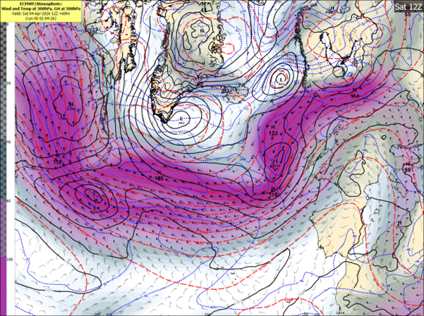
Fíor 2 Samhail ECMWF ag taispeáint an tsrutha scairde agus an bhrú aeir ar an Satharn – Stoirm Dave forbartha siar ó Éirinn
Fíor 3 Samhail DINI ag taispeáint na luasanna gaoithe réamhaisnithe do 7pm Dé Sathairn
Fíor 4 Samhail DINI ag taispeáint na frasaíochta réamhaisnithe tráthnóna Dé Sathairn
Domhnach, 5 Aibreán (Domhnach Cásca)
Beidh sé gaofar ar feadh tamaill le tréimhsí gréine agus ceathanna scaipthe. Beidh sé níos fuaire freisin agus titfidh cuid de na ceathanna mar chlocha sneachta agus mar fhlichshneachta ar thalamh ard, go háirithe san iarthar agus sa tuaisceart. Tá seans ann go mbeidh beagán sneachta ar chnoic níos faide ó thuaidh go luath ar maidin. D’fhéadfadh gaotha úra go láidre ón iarthar go luath Dé Domhnaigh, i gcomhar le tonnta arda, tonnta a chur thar chosaintí cósta agus tuilte a chruthú i gceantair ísle agus nochta. Tiocfaidh feabhas de réir a chéile i rith an lae de réir mar a mhaolóidh na gaotha agus a éireoidh na ceathanna níos scaipthe. Mar thoradh air sin beidh tráthnóna tirim, grianmhar Domhnach Cásca le gaotha níos séimhe.
Dé Luain, 6 Aibreán
Beidh lá gaofar ann ach beidh sé níos séimhe agus ní bheidh ach beagán báistí agus ceobhráin ann.
RABHAIDH AGUS TIONCHAIR: Tá na rabhaidh seo a leanas eisithe ag Met Éireann (amhail 3pm, Déardaoin, an 2 Aibreán):
Tá Rabhadh Gaoithe Buí eisithe ar fud na tíre mar gheall ar Stoirm Dave.
Tabharfaidh Stoirm Dave gaotha an-láidre ó dheas, a chasfaidh siar faoin tráthnóna, le séideáin throma agus galaí cósta.
Tionchair fhéideartha:
D’fhéadfaí na rabhaidh a nuashonrú de réir mar a dhéanfar anailís ar rithí nua na samhlacha agus de réir mar a mhéadóidh an chinnteacht.
Chun na sonraí is déanaí faoi na rabhaidh a fháil, féach ar Rabhaidh & Comhairle – Met Éireann – Seirbhís Náisiúnta Mheitéareolaíochta na hÉireann
Teachtaireachtaí Sábháilteachta Poiblí
CÉN FÁTH AGUS CONAS A AINMNÍTEAR STOIRMEACHA?
Ainmnítear stoirmeacha nuair a d’fhéadfadh siad tionchair ‘mheasartha’ nó ‘arda’ a bheith i gceann de na trí thír chomhpháirtíochta. Cumasaíonn sé seo teachtaireachtaí comhsheasmhacha agus údarásacha don phobal agus do pháirtithe leasmhara eile le cur ar a gcumas ullmhú agus fanacht sábháilte le linn tarluithe adhaimsire.
Ó 2015 i leith, tá Met Éireann agus Oifig Mheitéareolaíochta na Ríochta Aontaithe ag obair le chéile ar an gclár ainmniúcháin agus tháinig KNMI na hÍsiltíre leo i 2019 chun ‘grúpa an iarthair’ de sheirbhísí aimsire na hEorpa a fhoirmiú.
Nuair a fhógraítear stoirm, ainmníonn an tseirbhís náisiúnta aimsire a bhíonn ag súil leis an tionchar is mó ón aimsir chrua ar a réigiún nó is mó is dócha a bheidh buailte, an stoirm. Tarlaíonn ainmniú stoirme in éineacht le rabhaidh oráiste/dhearga, a d’fhéadfadh a bheith ann don ghaoth, don bháisteach nó don sneachta nó do mheascán díobh seo. Éisítear na rabhaidh, dá réir sin, bunaithe ar mheascán de thairseacha uimhriúla agus na tionchair fhéideartha a mheastar.
CONAS A ROGHNAÍTEAR AINMNEACHA STOIRMEACHA?
Foilsíonn Met Éireann, Oifig na Meitéareolaíochta na Ríochta Aontaithe agus KNMI liosta nua d’ainmneacha stoirme do gach séasúr stoirme, a thosaíonn an 1 Meán Fómhair.
Don séasúr 2025/26, chuir gach ceann de na trí sheirbhís meitéareolaíochta seacht n-ainm leis an liosta séasúir. D’iarr Met Éireann ar mhuintir na hÉireann a rogha ainmneacha a chur isteach trí fheachtas ar na meáin shóisialta. Fuarthas níos mó ná 10,000 ainm ó 4,137 duine den phobal.
Seo a leanas an liosta iomlán d’ainmneacha shéasúr 2025/26: Amy, Bram, Chandra, Dave, Eddie, Fionnuala, Gerard, Hannah, Isla, Janna, Kasia, Lilith, Marty, Nico, Oscar, Patrick, Ruby, Stevie, Tadhg, Violet, Wubbo.
Fíor 5 – Liosta Ainmneacha Stoirmeacha 2025/26
(Tá na hainmneacha a roghnaigh Met Éireann i gcló trom. Níl na litreacha Q, U, X, Y, Z san áireamh, tá sé seo ag teacht le gnás ainmnithe Lárionad Náisiúnta Hairicín na SA).
Foilsithe 01/04/2026 ——————— ———————–
Aimsir athraitheach thar dheireadh seachtaine na Cásca, le neamhchinnteacht sna sonraí
Intreoir
Tar éis seachtain a bhí níos tirime ná an gnáthleibhéal, meastar go dtiocfaidh meath ar an aimsir, le tréimhsí báistí, gaofar agus b’fhéidir stoirmiúil le teacht. Tá foláireamh aimsire eisithe mar gheall ar an mbaol aimsire suaithinseach, chomh maith le méadú ar nochtadh de bharr daoine a bheith ag taisteal don deireadh seachtaine fada Cásca agus tréimhse taoide earraigh. D’fhéadfadh gaotha láidre ón gcósta agus tonnta arda tonnta a chur thar chosaintí cósta agus tuilte a chruthú i gceantair ísle agus nochta. Tá neamhchinnteacht sna sonraí faoi láthair agus leanfaidh Met Éireann orthu ag monatóireacht ar an staid agus ag eisiúint nuashonruithe de réir mar a thagann soiléireacht.
Leagan Achoimre
Tá sraith lagbhrú ag bogadh gar d’Éirinn agus don Ríocht Aontaithe, ag dul i neart de réir a chéile. Tá an Scairdshruth le neartú agus le bogadh thar an tír, á spreagadh ag difríocht mhéadaithe teochta idir aer fuar ón iarthuaisceart agus aer níos séimhe ón iardheisceart. Tagann an neamhchinnteacht as an bhfíric nach bhfuil na córais seo lánfhorbartha fós, agus go bhféadfadh fiú athrú beag ina suíomh tionchar mór a imirt ar neart na ngaoth agus ar dhéine na stoirme.
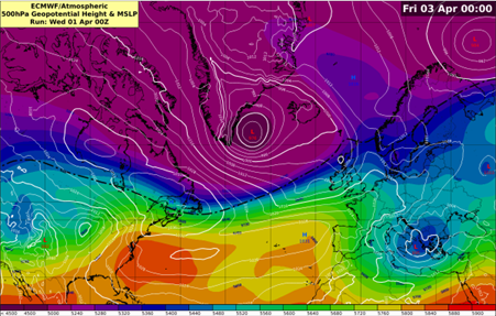
Fíor 1 Samhail Lárionaid Eorpach do Réamhaisnéisí Aimsire Meánraoin (ECMWF) ag taispeáint grádán láidir teochta
Fíor 2 Samhail ECMWF ag taispeáint an Scairdshruth ag neartú os cionn na hÉireann
Dé hAoine, 3 Aibreán (Aoine an Chéasta)
Meastar go n-éireoidh sé gaofar, go háirithe níos déanaí ar maidin agus tráthnóna luath, de réir mar a ghluaiseann ísealbhrú forbartha trasna na tíre. Tugann an treoir reatha le fios nach meastar go mbeidh doimhniú pléascach ann, ach d’fhéadfadh gaotha láidre agus tréimhsí ceathanna báistí a bheith ann.
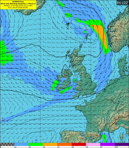
Fíor 3 Samhail ECMWF ag taispeáint na luasanna gaoithe tuartha Dé hAoine
Fíor 4 Samhail ECMWF ag taispeáint frasaíocht tuartha Dé hAoine
Dé Sathairn, 4 Aibreán
Lá fliuch agus gaofar le tréimhsí báistí, trom in amanna, agus seans tuilte áitiúla. D’fhéadfadh gaotha an-láidre ón iardheisceart forbairt níos déanaí sa lá, go háirithe in áiteanna san iarthar agus san iarthuaisceart. Méadóidh taoidí arda réalteolaíocha (Taoidí Earraigh), i gcomhar le borradh stoirme agus gaotha leanúnacha ón gcósta, an baol tuilte cósta tuilleadh. Tá limistéir feadh chóstaí an iarthair agus an tuaiscirt go háirithe leochaileach.
Fíor 5 Samhail ECMWF ag taispeáint na luasanna gaoithe tuartha Dé Sathairn
Fíor 6 Samhail ECMWF ag taispeáint frasaíocht tuartha Dé Sathairn
Domhnach, 5 Aibreán (Domhnach Cásca)
Lá measartha gaofar le ceathanna. Beidh sé níos fuaire freisin, agus titfidh cuid de na cithfholcadáin mar fhlichshneachta, go príomha san iarthar agus sa tuaisceart, agus tá seans ann go mbeidh sneachta ar thalamh ard. D’fhéadfadh go mbeadh scaileogú agus tuilte a chruthú i gceantair ísle agus nochta mar gheall ar ghaotha láidre ón iarthar go luath Dé Domhnaigh, i gcomhar le tonnta arda.
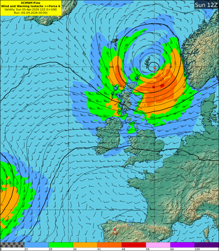
Fíor 7 Samhail ECMWF ag taispeáint na luasanna gaoithe tuartha Dé Domhnaigh
Fíor 8 Samhail ECMWF ag taispeáint frasaíocht tuartha Dé Domhnaigh
Dé Luain, 6 Aibreán
D’fhéadfadh lá gaofar eile a bheith ann, ach tugann na réamhaisnéisí reatha le fios go bhfanfaidh an ghaoth agus an bháisteach is measa amach ón gcósta.
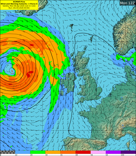
Fíor 9 Samhail ECMWF ag taispeáint na luasanna gaoithe tuartha Dé Luain
Fíor 10 Samhail ECMWF ag taispeáint frasaíocht tuartha Dé Luain
Teachtaireachtaí Sábháilteachta Poiblí
——————— ———————–
Feabhra 17: Baol tuilleadh tuilte de réir mar a leanann an aimsir athraitheach
Forbhreathnú
I bhfianaise na báistí a thit le déanaí, leibhéil na n-aibhneacha agus na ndálaí atá ann cheana, tá seans ann go mbeidh tuilleadh tuilte sa deisceart, san oirdheisceart, i lár na tíre, san oirthear agus san oirthuaisceart Dé Céadaoin agus ag leanúint isteach Déardaoin. Tá foláirimh bháistí agus ghaoithe eisithe don Chéadaoin, agus tá foláireamh báistí agus sneachta eisithe do Dhún na nGall freisin.
D’fhéadfadh taoidí earraigh sna laethanta amach romhainn, i gcomhar le gaotha láidre agus borradh stoirme, bac a chur ar shileadh uisce ó aibhneacha agus an baol tuilte a mhéadú i gceantair chósta agus inbhir atá íseal, go háirithe tráth na hardtaoide.
An scéal
Leanann lagbhrú Atlantach de bheith ag stiúradh ár bpatrúin aimsire, agus tá córas eile lagbhrú ag druidim le hÉirinn inniu. Tabharfaidh sé seo tréimhsí measartha forleathana de bháisteach throm thar oíche agus Dé Céadaoin. Beidh na méideanna báistí is mó sa leath thoir den tír, agus glanfaidh an bháisteach ó cheantair an iarthair faoi luath-thráthnóna. In éineacht leis an mbáisteach, a bheidh trom in amanna agus a d’fhéadfadh tuilte dromchla agus tuilte abhann a chruthú, meastar freisin go bhforbróidh gaotha láidre siotacha ón oirdheisceart, agus beidh stoirmeacha feadh na gcóstaí. Tiocfaidh na gaotha is láidre san oirthear le hardtaoide maidin Dé Céadaoin feadh an chósta thoir, rud a mhéadóidh an baol go mbeidh scaileogú agus go mbeidh tuilte cósta i gceantair ísle atá i mbaol tuilte. San iarthuaisceart, casfaidh an bháisteach ar aer fuar agus d’fhéadfadh sí titim mar fhlichshneachta nó mar shneachta ar feadh tamaill, go háirithe ar thalamh ard, sula n-iompóidh sí ar ais ina báisteach níos déanaí sa lá. Beidh sé an-ghaofar san iarthar agus san iarthuaisceart freisin.
Lean an treocht d’aimsir níos fliche ná an meán san oirthear agus sa deisceart isteach i mí Feabhra, agus tá idir trí huaire agus ceithre huaire an ghnáthmhéid báistí taifeadta i gcodanna den oirthear le linn an chéad choicíse den mhí Feabhra. Léiríonn an íomhá thíos na méideanna báistí a taifeadadh ar fud na tíre le ceithre lá dhéag anuas, agus na diallais is mó ón meán le feiceáil san oirthear.
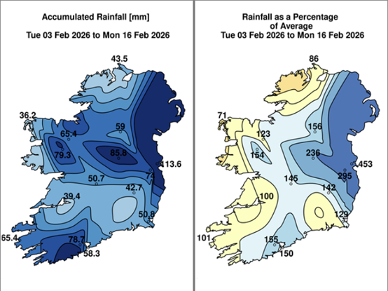
Fíor 1: Báisteach: An ceithre lá dhéag seo caite
Fíor 2: Réamhaisnéis DINI maidir le báisteach agus gaoth don Chéadaoin
Comhairle Sábháilteachta don Phobal
Báisteach Throm Déardaoin agus Dé hAoine, 5 agus 6 Feabhra
Nuashonraithe 5 Feabhra 2026
Beidh tréimhse báistí ag scaipeadh trasna na tíre inniu agus amárach, agus beidh an bháisteach is troime san oirdheisceart agus san oirthear. Beidh sé gaofar freisin, le gaotha láidre ón oirthear agus stoirmeacha feadh na gcóstaí thoir.
Tagann sé seo i ndiaidh seachtaine de bháisteach leanúnach, agus tá go leor aibhneacha ag a mbruacha nó os a gcionn, agus tá ithreacha sáithithe nó faoi uisce ar fud na tíre. Mar thoradh air sin, is dócha go mbeidh tuilleadh tuilte mar thoradh ar an mbáisteach atá tuartha don lá inniu agus don lá amárach.
Ina theannta sin, méadóidh taoidí arda earraigh, i gcomhar le gaotha láidre ón gcósta agus borradh stoirme, an baol go mbeidh scaileogú agus tuilte cósta ann inniu, agus cuirfidh siad srian freisin ar dhoirteadh abhann.
Tá foláirimh bhuí bháistí i bhfeidhm inniu agus amárach do chontaetha san oirthear, sa deisceart agus i gcodanna de lár na tíre. Tá foláirimh oráiste bháistí i bhfeidhm freisin do Phort Láirge, Chill Mhantáin, Áth Cliath agus Lú.
Check Féach ar Fholáirimh agus ar Chomhairle ar met.ie chun na sonraí is déanaí faoi na foláirimh a fháil.
Forbhreathnú
Leanfaidh an patrún aimsire marthanach, ina bhfuil an scairdsruth aistrithe níos faide ó dheas agus ag giniúint córais lagbhrú ó dheas agus ó dheas siar d’Éirinn, ar aghaidh i rith na tréimhse réamhaisnéise. Mar thoradh air sin, fanfaidh méideanna báistí os cionn an mheáin i ndeisceart agus in oirthear na tíre, agus meastar go mbeidh méideanna báistí gar don mheán nó faoi bhun an mheáin san iarthar agus san iarthuaisceart.
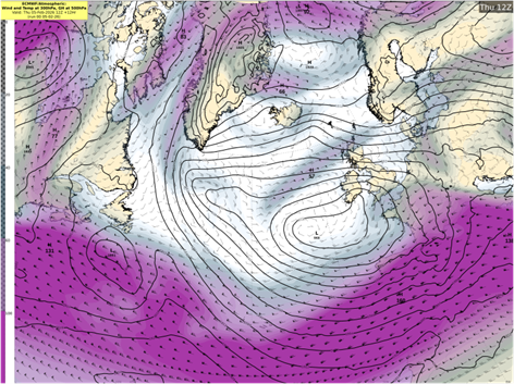
Fíor 1: Brú meánach ag leibhéal na farraige agus an Scairdsruth bailí ag 1200 Déardaoin, an 5 Feabhra
An Scéal ar an Talamh
Is báisteach rialta agus ag imeachtaí báistí go háitiúil a bhí ar siúl le seachtainí beaga anuas. Léiríonn an íomhá thíos na méideanna báistí a taifeadadh ar fud na tíre le ceithre lá dhéag anuas, agus na diallais is mó ón meán le feiceáil sa deisceart agus san oirthear.
Fíor 2: Báisteach charntha agus an bháisteach mar chéatadán den mheán le ceithre lá dhéag anuas
Tar éis na báistí le déanaí, tá go leor aibhneacha ag leibhéal a mbruacha nó os a gcionn. Mar gheall ar an mbáisteach sin, i gcomhar le hithreacha sáithithe, tá ardú suntasach tagtha ar leibhéil na n-aibhneacha agus ar charnadh uisce dromchla, go háirithe san oirdheisceart agus san oirthear.
An Bháisteach atá Tuartha
Tá foláirimh bháistí i bhfeidhm inniu agus don chuid is mó den lá amárach i gceantair sa deisceart, san oirthear agus i gcodanna den oirthuaisceart. Tá foláirimh oráiste bháistí i bhfeidhm do Phort Láirge, Chill Mhantáin, Áth Cliath agus Lú, agus tá foláirimh bhuí bháistí i bhfeidhm do Cheatharlach, Chill Dara, Chill Chainnigh, Laois, Loch Garman, Tiobraid Árann, an Cabhán, Muineachán agus an Mhí.
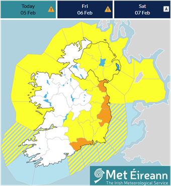
Fíor 3: Foláirimh i bhfeidhm ag 1200 Déardaoin, an 5 Feabhra
Tar éis bháisteach throm na seachtaine seo caite, tá go leor aibhneacha fós gar do leibhéal a mbruacha nó os a gcionn, agus de bharr na hithreach sáithithe tá dobharcheantair an-íogair d’aon bháisteach bhreise. Cé go bhfuil buaicleibhéal bainte amach ag formhór na n-aibhneacha nó go bhfuil siad cobhsaithe, agus cé go bhfuil cuid acu íslithe anois, tá leibhéil na n-aibhneacha fós ard.
Scaipfidh tréimhsí báistí troma ón oirdheisceart inniu, anocht agus amárach, agus meastar go mbeidh na méideanna is mó báistí sna réigiúin theas agus thoir atá faoi fholáirimh oráiste agus bhuí. I bhfianaise na leibhéal reatha sna haibhneacha agus na ndálaí talún, d’fhéadfadh báisteach mheasartha fiú, tuilleadh tuilte áitiúla a chruthú, go háirithe in aibhneacha síos an sruth ó Shléibhte Chill Mhantáin, ó Shléibhte Chomaraigh agus ó Leithinis Chuaille.
Taoidí Arda Earraigh
Ina theannta sin, méadóidh taoidí arda earraigh, i gcomhar le gaotha láidre ón gcósta agus borradh stoirme, an baol go mbeidh scaileogú agus tuilte cósta ann i gceantair sceirdiúla Déardaoin. Cuirfidh leibhéil arda uisce feadh an chósta srian freisin ar shileadh uisce ó aibhneacha, rud a mhéadóidh an baol tuilte i gceantair chósta ísle agus inbhir, go háirithe tráth na hardtaoide.
Amach romhainn
Tar éis na haimsire fliche Déardaoin agus Dé hAoine, beidh faoiseamh éigin i ndán ag an deireadh seachtaine. Cé go mbeidh ceathanna ann, beidh tréimhsí níos faide tirime freisin. Ligfidh sé seo do leibhéil uisce sa líonra aibhneacha titim de réir a chéile.
Comhairle Sábháilteachta don Phobal
Tá an t-eolas is déanaí faoin bhfreagairt éigeandála ar fáil ag www.gov.ie/FloodResponse.
Wet weather continues for the start of February with ongoing flood risks for the east and southeast
After a week of persistent rain, many rivers are at or above bank-full conditions. Soils are saturated or waterlogged in many places across the country, increasing the risk of further river and surface water flooding.
Any additional rainfall over the course of the coming few days is expected to result in river and surface water flooding, particularly in the midlands, southern, southeastern, northeastern, and eastern counties. Rivers are expected to overflow their banks, and smaller tributaries may flood more rapidly.
We are also entering a period of high spring tides with strong onshore winds, particularly along southern and eastern coasts. This will increase flood risk in low-lying coastal areas.
Ground Situation
The month of January has been characterised by frequent rainfall and localised extremes. The image below depicts the above normal rainfall amounts countrywide over the past seven days with the largest deviations from the average in the south and east.
Figure 1: Rainfall: Past seven days
Following recent rainfall, many rivers are at or above bank-full levels. This rainfall, combined with saturated soils, has caused significant rises in river levels and surface water accumulation, particularly across southeastern and eastern areas.
Figure 2: Jetstream from Monday to Wednesday.
A strong jet stream has maintained to our south which is helping to keep an area of low pressure anchored off our southwest coast. This will in turn generate spells of rain over the coming week which will mostly affect counties in the south and east.
Rain will arrive into the south of the country across Munster and south Leinster Monday evening. Below is Met Eireann’s own ensemble members all in close agreement with the rainfall location.
Figure 3: DINI EPS 1hr rainfall.
Taking a further look at our DINI-EPS Probability charts below we can see thresholds for yellow level warnings are increasingly likely in the south and east.
Figure 4: DINI EPS rainfall accumulation probabilities.
With the high river levels in these areas together with saturated ground further river flooding is possible in these locations. Yellow level rainfall warnings have been issued for Monday and into Tuesday with impacts including localised and river flooding.
The latest Met Eireann warnings are here Warnings & Advisories – Met Éireann – The Irish Meteorological Service
High spring tides early next week, combined with strong winds and surge, may cause wave overtopping and coastal flooding along all coasts, especially in low lying coastal areas.
High coastal levels will impede river discharge and increase flood risk in low-lying coastal and estuarine areas, especially at high tide.
For much of the week the winds are expected to be south to southeasterly too which is an onshore direction for counties across Munster and Leinster. This combined with high tides can further exacerbate the synoptic setup.
Looking ahead to the rest of the week and low pressure remains dominant. This in turn will result in spells of rain continuing across the south and east.
Over the coming week more than twice or possibly three times the average amount of rainfall is expected.
Figure 5: ECMWF rainfall accumulation projections
Taking a closer look across our ECMWF ensemble forecast for rainfall accumulations we can expect between 30 to 45mm from Sunday February 1st until Friday February 6th.
Figure 6: ECMWF mean rainfall accumulations until Friday 6th February.
While this rainfall is expected to come in spells over the course of the next few days starting Monday evening it will fall on already very saturated ground.
The above forecast gives a mean outcome but it’s possible that some accumulations may be slightly above or below the figures seen above.
As such and with the overall unsettled pattern of weather expected, additional rainfall over the coming days in the East, Southeast and South could cause further river flooding. Fast responding and upland catchments are most at risk.
Public Safety Advice
The Aftermath of Storm Chandra: Ground conditions, uncertainties, predicted rainfall and flooding possibilities
Updated Friday 30th January 2026, valid until further notice
After a week of persistent rain, many rivers are at or above bank-full conditions and rainfall has caused both river levels and surface water levels to rise significantly.
Soils are saturated or waterlogged in many places across the country, increasing the risk of further river and surface water flooding. Any additional rainfall today and over the weekend is expected to result in river and surface water flooding, particularly in the midlands, southeastern, northeastern, and eastern counties. Rivers are expected to overflow their banks, and smaller tributaries may flood more rapidly.
A yellow rainfall warning is in place for southeastern, northeastern, eastern counties from midday on Friday 30th until midnight, so staying up to date with the weather and with your local authority is strongly advised.
Check Warnings & Advisories on met.ie for all the warning details.
From tomorrow (Saturday), the weather will become drier through to Sunday and for the first half of Monday. There will still be rain or showers around, but generally lighter and patchier in nature. The best of the bright or sunny spells will be on Sunday. Winds will be slack for the most part too, though a little breezier on Monday with the chance of further rain moving up from the south later in the day.
…………………………………………………………………………………………………………………..
Issued Thursday 29th January 2026
Overview
Given recent rainfall, river levels and antecedent conditions, further flooding is possible in places over the coming days. Currently, rainfall warnings have been issued for today (Thursday) and tomorrow (Friday). While there are some uncertainties in the weather forecast, especially for Friday, rainfall amounts that could be below warning thresholds may be enough to result in large impacts.
Ground Situation
The month of January has been characterised by frequent rainfall and localised extremes. The image below depicts the above normal rainfall amounts countrywide over the past seven days with the largest deviations from the average in the south and east.
Figure 1: Rainfall: Past seven days
Following recent rainfall, many rivers are at or above bank-full levels. This rainfall, combined with saturated soils, has caused significant rises in river levels and surface water accumulation, particularly across southeastern and eastern areas.
Uncertainty for Friday
A secondary developing depression is forecast to track near to the country on Friday but there has been a huge amount of uncertainty with the track of this system and by extension, the associated rainfall that can be expected with it.
Figure 2 ECMWF Jet Stream and MSLP
The global ECMWF deterministic forecast is predicting the system to get caught up in the left exit of the Jet Stream allowing it to deepen rapidly. However, it is predicting it to be on the very boundary of the Jet so a slight deviation in the positioning would result in a very different outcome.
Figure 3 DINI-EPS Individual members showing 1 hour rainfall
Figure 4 DINI-EPS 12 hour accumulations for Friday
Met Éireann’s own ensemble forecasting system (DINI-EPS) shows a range of possible outcomes of the rainfall associated with this system. While areas may not reach warning thresholds, flooding remains a likelihood. A status yellow rainfall warning has been issued due to the potential for further heavy rain and showers in areas that have already seen significant flooding due to Storm Chandra.
Predicted Rainfall over coming days and Flooding Possibilities
At the moment, rainfall warnings are in effect for today (Thursday) and tomorrow (Friday) for southeastern, northeastern and eastern areas. Many rivers in the southeast, east, and northeast are at or above bank-full levels, and river levels are generally high in other areas. Soils are saturated and waterlogged in many areas, with little improvement in soil conditions forecast in the coming days. Any additional rainfall, particularly in southeastern, northeastern, and eastern areas, could cause further river flooding. Fast-responding and upland catchments are most at risk.
Given the uncertainties for Friday, there is a range of possible rainfall accumulations but ensemble forecasts are a way to give overall guidance by looking at the mean or average amounts of predicted rainfall. It is important to note that due to the figures above being an average of ensemble members, there is the potential for higher or lower rainfall amounts.
Figure 5 ECMWF Ensemble Mean Rainfall from Thursday to Monday inclusive
There is a strong signal though for southeastern and eastern areas, which have seen the largest accumulations in recent days, to experience the majority of the rainfall out to Monday inclusive.
While the forecast is for some drier spells to develop during the weekend, there are rivers and catchments that are slower to respond to rainfall so there can be delayed impacts.
Public Safety Advice
Storm Chandra Impacting Eastern and Southern counties on Tuesday, 27th January 2026
Updated, January 26th at 19:45 and valid until further notice
A low-pressure system, named Storm Chandra by the UK Met Office, will bring strong winds and heavy rain to Ireland from the night of Monday, January 26th and during Tuesday, January 27th.
Meteorologist Rebecca Cantwell, says:
“Storm Chandra is a low-pressure system that will track northwards over the country Monday night and Tuesday, bringing with it rather wet and windy conditions. It will bring heavy spells of rain with strong winds, especially along the coast. It will slowly clear northwards later on Tuesday.
Given the unsettled spell of weather we’ve experienced over the last while, this rain will fall on already saturated ground, combined with the fact that many rivers are approaching or exceeding bank-full conditions, and so we are expecting localised flooding and river flooding as a result. We have issued yellow level rainfall warnings for southeastern counties where the rain is expected to have the greatest impacts.
This rain will also be accompanied by strong and gusty winds, affecting especially coastal areas, so yellow wind warning has been issued for the entire country.”
Rebecca continues:
“The compound effect of the wind and rain will make for some difficult travelling conditions during the validity period of the warnings and so we would urge people to keep that in mind when out and about. The winds will be strongest near coasts and exposed areas with wave overtopping possible and so we echo the well-known advice of the Irish Coast Guard: “Stay Back, Stay High, Stay Dry”. In summary, stay back from rivers, lakes and the coasts and avoid flooded roads, following the latest guidance from your local authority and road authorities.”
METEOROLOGICAL SITUATION
A strong polar front jet, as a result of the cold air outbreak over North America, will see the system deepen rapidly to the south of Ireland within the left exit of the jet stream. The storm will approach the south coast overnight before tracking northwards over Ireland during Tuesday.
Fig. 1: Wet bulb potential temperature
Initially a band of persistent rain will push up from the southeast bringing widespread rainfall. The system is forecast to meet a relatively cool airmass as it moves northwards, bringing the potential for mixed precipitation with a chance of falls of sleet over higher ground in the north and northwest in the morning. This rain will clear northwards and will be followed by a brief period of drier and brighter weather before the same system swings back around and feeds further outbreaks of rain up over the country. Wet and windy conditions will affect all areas with southern and eastern counties expected to see the highest rainfall accumulations.
Fig. 2: The current DINI model prediction of the rainfall, at the time of publication on Monday 26th January, subject to changes.
WARNINGS AND IMPACTS: Met Éireann has issued the following warnings (on 26th January at time of publication):
A Status Yellow rain warning across southeastern counties, with heavy and persistent rain expected to fall on already saturated ground and with many rivers approaching bank full conditions after a spell of wet and unsettled weather.
Potential impacts are:
A nationwide Status Yellow wind warning due to strong and gusty winds associated with Storm Chandra, strongest along the coasts and exposed areas.
Potential impacts include:
The warnings may be updated as new model runs are analysed and certainty increases. For the latest warnings details, please check Warnings & Advisories – Met Éireann – The Irish Meteorological Service
HOW TO STAY SAFE IN SEVERE WEATHER – BE WINTER READY
Stay informed & plan ahead:
This is a multi-hazard event – be aware of elevated flood risk and strong winds:
NOTE THAT: The warnings are likely to be updated. Please keep in touch with Met Éireann’s social media channels, www.met.ie and the Met Éireann app to stay up to date with the forecast and any warnings’ updates.
The timing and location of extreme weather occurrences can significantly affect their impact. It’s important to note that in any individual weather event, not every location within a warning area may experience the same degree of weather or impacts.
When severe weather is expected, weather and impacts at lower levels are also likely to be experienced. The type and level of impacts can be strongly affected by previous weather conditions. When issuing a warning, Met Éireann takes into consideration the forecast conditions and thresholds, as well as previous weather conditions that may increase the level of impact expected for particular areas.
WHY AND HOW ARE STORMS NAMED?
Storms are named when they could cause ‘medium’ or ‘high’ impacts in one of the three partner countries. This enables consistent, authoritative messaging to the public and other stakeholders to help them to prepare for and stay safe during potentially severe weather events.
Since 2015, Met Éireann and the UK Met Office have been working together on the naming programme and were joined by the Netherlands’ KNMI in 2019, to form the ‘western group’ of European weather services.
When a storm is forecast, the national weather service that expects the biggest impact from the severe weather to hit its region, or is likely to be first affected by it, names the storm. Storm naming happens in conjunction with orange/red weather warnings, which could be for wind, rain or snow, or a combination of these conditions. Those warnings are, in turn, issued based on a combination of numerical thresholds and the potential impacts foreseen.
HOW ARE STORM NAMES CHOSEN?
Met Éireann, the UK Met Office and KNMI publish a new list of storm names for each Storm Season, which commences on 1st September.
This 2025/26 season, each of the three meteorological services contributed seven names to the season’s list. Met Éireann called on Ireland’s public to submit their preferred names through a social media campaign. More than 10,000 names were received from 4,137 members of the public.
The full 2025/26 list is Amy, Bram, Chandra, Dave, Eddie, Fionnuala, Gerard, Hannah, Isla, Janna, Kasia, Lilith, Marty, Nico, Oscar, Patrick, Ruby, Stevie, Tadhg, Violet, Wubbo.
Figure 3– Storm Names 2025/26 list (The names chosen by Met Éireann are in bold. Letters Q, U, X, Y, Z are not included, which is in line with the US National Hurricane Center naming convention).
JANUARY STORMS IN IRELAND
January storms are a normal part of the Irish climate, with the Atlantic storm track often at its most active, so we commonly see spells of widespread rain, strong to gale force winds, very rough seas, coastal overtopping, and a higher flooding risk when soils and rivers are already bank full. It is not unusual to have a strong jet stream in January, it is quite typical. Currently the jet stream is to our south rather than to the north.
Since the storm naming project began, three of the eleven storm seasons (2017, 2019 and 2023) had no storms in January.
The historical record shows the range from disruptive to extreme: the Night of the Big Wind on 6 to 7 January 1839 was about 187 years ago, the major windstorm of 5 January 1991 was about 35 years ago, Violent Storm Isha on 21 January 2024 was just over 2 years ago, and Hurricane strength Éowyn on 24 January 2025 was just over 1 year ago, showing that while January storminess is expected, the standout events are less frequent and tend to be remembered for decades.
PAST STORM SEASONS OVERVIEW
For more information on storm names and past storms, see Storm Centre and Major Weather Events.
2026 gets Underway with Cold and Wintry Conditions
2026 gets underway with cold and wintry conditions
Met Éireann is forecasting a cold and wintry start to the new year as a northerly air-flow becomes established over Ireland, drawing down polar air across the country. Temperatures are expected to fall below average, with the main impacts being frosty and icy nights. There will also be some sleet and snow showers at times, mainly affecting Ulster and north Connacht, while many other areas will experience crisp, bright conditions with plenty of winter sunshine.
People are advised to be prepared for the colder weather and potential hazards, particularly overnight and during the early mornings. The public is encouraged to plan ahead, allow extra time for journeys and take care on icy roads. Met Éireann will continue to monitor conditions and provide updates as the cold spell develops.
Meteorologist Matthew Martin says:
“It is now increasingly likely that a very cold, Arctic air mass will move across Ireland over the coming days. This is being driven by a blocking high-pressure system building in the Atlantic, which will allow the air-flow to turn northerly and draw very cold air southwards from the Arctic.”
“We are expecting very cold and frosty nights, particularly over the weekend, with a chance of some wintry showers. At present, these showers are most likely to affect northern counties, while many southern areas can expect plenty of crisp winter sunshine. We will continue to assess the situation closely in the coming days and will issue any warnings as required, so people are advised to keep a close eye on the forecast.”
(Fig1: A very cold northerly air-flow is forecast to become established over Ireland this weekend bringing frost, ice and some wintry showers)
HOW TO STAY SAFE DURING WINTRY WEATHER – BE WINTER READY
NOTE THAT:
Warnings can be updated. Please keep in touch with Met Éireann’s social media channels, www.met.ie and the Met Éireann app to stay up to date with the forecast and any warnings’ updates.
The timing and location of extreme weather occurrences can significantly affect their impact. It’s important to note that in any individual weather event, not every location within a warning area may experience the same degree of weather or impacts.
When severe weather is expected, weather and impacts at lower levels are also likely to be experienced. The type and level of impacts can be strongly affected by previous weather conditions. When issuing a warning, Met Éireann takes into consideration the forecasted conditions and thresholds, as well as previous weather conditions that may increase the level of impact expected for particular areas.
Heavy rain affecting Ireland on Saturday 13th and through Sunday 14th December
Updated Saturday 13th December 2025, valid until further notice
Heavy rain will affect Ireland from later Saturday through Sunday
Overview
Meteorologist Gerry Murphy says:
‘The heavy, persistent rainfall forecasted will bring a high risk of river flooding across western parts of Cork, Kerry, Limerick, Clare, Galway, Mayo and Donegal for later Saturday 13th, Sunday 14th and into Monday 15th December, as the soils are saturated and river levels high. In recent weeks, the weather over Ireland has been very unsettled with spells of heavy rain moving across the country. Many rivers are swollen and approaching bank-full conditions.
On Saturday 13th December a weather front will move eastwards over Ireland with rain gradually spreading to all areas. The front will become slow-moving over the country. Spells of heavy rain will feed in from the southwest through Saturday night, Sunday and for a time on Sunday night. Predicted heavy rainfall for this weekend is likely to result in river flooding, particularly in flood-prone catchments. Waterlogged soils will reduce infiltration and increase overland flow. Large rivers may overflow their banks, while smaller tributaries may respond more rapidly and flood sooner. Western coastal and mountainous catchments are particularly at risk of river flooding during this event. The flood risk will persist from Saturday evening into Sunday and through the following days due to continued forecasted rainfall and slow drainage from saturated catchments.’
WARNINGS & IMPACTS:
Yellow and orange level rainfall warnings have been issued and can be viewed on Warnings & Advisories – Met Éireann – The Irish Meteorological Service
Impacts include:
For complete and up to date information on the warnings please check Warnings & Advisories – Met Éireann – The Irish Meteorological Service
Rainfall Forecast Saturday 13th to Sunday 14th December 2025
Meteorological Situation
Figure 1: The current ECMWF model prediction of the position of the jet stream at 12 noon Saturday 13th December
A strong westerly jetstream steers active weather systems across the Atlantic and over Ireland bringing spells of wet and sometimes windy weather over the country.
Figure 2: Airmass analysis chart at 0600UTC Saturday 13th December
A depression of 956hPa south of Greenland moves eastwards. As its associated weather fronts approach Ireland, a deepening depression will develop and will bring heavy rain and strong winds over Ireland on Saturday and Sunday. Wave features will cause the fronts to become slow-moving. This will mean that spells of heavy rain will move in over Ireland through Saturday night and Sunday, before eventually clearing early on Monday.
HOW TO STAY SAFE IN SEVERE WEATHER – BE WINTER READY
NOTE THAT:
The warnings are likely to be updated. Please keep in touch with Met Éireann’s social media channels, www.met.ie and the Met Éireann apps to stay up to date with the forecast and any warnings’ updates.
The timing and location of extreme weather occurrences can significantly affect their impact. It’s important to note that in any individual weather event, not every location within a warning area may experience the same degree of weather or impacts.
When severe weather is expected, weather and impacts at lower levels are also likely to be experienced. The type and level of impacts can be strongly affected by previous weather conditions. When issuing a warning, Met Éireann takes into consideration the forecasted conditions and thresholds, as well as previous weather conditions that may increase the level of impact expected for particular areas.
Storm Bram bringing very strong winds and heavy rain
Updated on Tuesday, 9th December 2025, valid until further notice
A deepening Atlantic low-pressure system, named Storm Bram by Met Éireann, will bring strong winds and heavy rain to Ireland on the night of Monday 8th December and during Tuesday 9th.
Met Éireann is closely monitoring a developing Atlantic system expected to bring strong winds, high coastal water levels, and periods of heavy rainfall to Ireland from late Monday night (8th December) through Tuesday (9th December).
After a week of persistent rain, soils across the country are already highly saturated and many rivers are approaching bank-full conditions, so any additional rainfall is likely to result in surface and river flooding on Tuesday and possibly during following days.
WHY HAS IT BEEN NAMED?
Met Éireann has been monitoring this system for a number of days now, and while it is a very unstable system, not yet developed at the time of naming it, it is clear that it will bring compound impacts to a number of counties during the daytime on Tuesday 9th December, due to the interaction of the strong winds with the rain and the coinciding high tides. The storm has been named due to the effect of those strong winds on coastal areas at times of high tide, and the heavy rain falling on already saturated ground, all of which increase flood risk.
Meteorologist Matthew Martin, says:
“It’s looking increasing likely that Ireland will experience some very inclement weather from Monday night and through Tuesday. A low-pressure system in the Atlantic is going to deepen fairly rapidly as it approaches the southwest coast on Monday night. Initially there will be a spell of heavy rain before a swathe of very strong winds develop. There remains some uncertainty in the track and intensity of the system, but it looks likely that this will be an impactful event in some areas, especially in coastal areas of the south, west and northwest. Given its evolving nature, we have issued a yellow wind warning for the entire country, followed by a set of orange wind warnings for southern and western coastal counties, as they are most vulnerable to the compound effects of the wind at high tide. We have also issued a yellow rainfall warning for Carlow, Kilkenny, Wexford, Cork, Kerry, Tipperary and Waterford, but we encourage everyone to check in regularly with Met Éireann’s forecasts and warnings, as the situation is likely to evolve with certainty in the system track and timings increases.”
Matthew continues:
“Flooding impacts are expected as the rain will fall on already saturated ground and many rivers are currently approaching bank full conditions. We are in a period of high astronomical tides, which will coincide with the strong, potentially onshore winds, so there is high risk of coastal flooding. We echo the well-known advice of the Irish Coast Guard: “Stay Back, Stay High, Stay Dry”.
The high tides will prevent the rivers from discharging to the sea, significantly increasing the risk of upstream flooding along low-lying areas. People should refer to the guidance of their local authorities and emergency responders in their area.”
METEOROLOGICAL SITUATION
A deepening Atlantic depression is forecast to track close to Ireland on Monday night and Tuesday.
Southerly winds ahead of the system will strengthen on Monday night, with periods of severe wind gusts possible, especially near exposed Atlantic coasts. The strong winds will continue through Tuesday, veering southwest to west in direction during the day. Heavy rainfall late Monday into Tuesday morning will fall over ground that is already water-logged, increasing runoff and river response times.
Confidence remains moderate regarding the exact track and intensity of the system; small shifts will influence the severity of impacts. A slight shift in the system’s path could influence peak wind gusts, timing of strongest winds, and the extent of coastal impacts. Met Éireann will continue to monitor the system closely and update warnings as required.
Fig. 1: The current ECMWF model prediction of the position of the low-pressure system at midday on Tuesday (9 December), at the time of publication on Monday 8th December, subject to changes.
WARNINGS AND IMPACTS: The intensity of the winds and their impacts will depend on the interaction of the low with the jet stream, but as a mean for awareness of the potential impacts, Met Éireann has issued the following warnings (on 7th December at time of publication):
A Status Yellow rain warning across southern counties, with heavy rain expected to fall on already saturated ground and with many rivers in southern regions approaching bank full conditions after a week of steady rain.
Expected impacts, throughout Tuesday (even if the rain warning will expire on Tuesday morning) are:
A Status Yellow wind warning for Ireland all day Tuesday, followed by Orange wind warning for southern and western counties which have been extended to all counties in Ireland for different times across Tuesday, due to very strong to gale force southerly winds expected, strongest along the coast.
Expected impacts include:
The warnings may be updated as new model runs are analysed and certainty increases. For the latest warnings details, please check Warnings & Advisories – Met Éireann – The Irish Meteorological Service
HOW TO STAY SAFE IN SEVERE WEATHER – BE WINTER READY
Stay informed & plan ahead:
This is a multi-hazard event – be aware of elevated flood risk and high winds:
NOTE THAT: The warnings are likely to be updated. Please keep in touch with Met Éireann’s social media channels, www.met.ie and the Met Éireann app to stay up to date with the forecast and any warnings’ updates.
The timing and location of extreme weather occurrences can significantly affect their impact. It’s important to note that in any individual weather event, not every location within a warning area may experience the same degree of weather or impacts.
When severe weather is expected, weather and impacts at lower levels are also likely to be experienced. The type and level of impacts can be strongly affected by previous weather conditions. When issuing a warning, Met Éireann takes into consideration the forecasted conditions and thresholds, as well as previous weather conditions that may increase the level of impact expected for particular areas.
WHY AND HOW ARE STORMS NAMED?
Storms are named when they could cause ‘medium’ or ‘high’ impacts in one of the three partner countries. This enables consistent, authoritative messaging to the public and other stakeholders to help them to prepare for and stay safe during potentially severe weather events.
Since 2015, Met Éireann and the UK Met Office have been working together on the naming programme and were joined by the Netherlands’ KNMI in 2019, to form the ‘western group’ of European weather services.
When a storm is forecast, the national weather service that expects the biggest impact from the severe weather to hit its region, or is likely to be first affected by it, names the storm. Storm naming happens in conjunction with orange/red weather warnings, which could be for wind, rain or snow, or a combination of these conditions. Those warnings are, in turn, issued based on a combination of numerical thresholds and the potential impacts foreseen.
HOW ARE STORM NAMES CHOSEN?
Met Éireann, the UK Met Office and KNMI publish a new list of storm names for each Storm Season, which commences on 1st September.
This 2025/26 season, each of the three meteorological services contributed seven names to the season’s list. Met Éireann called on Ireland’s public to submit their preferred names through a social media campaign. More than 10,000 names were received from 4,137 members of the public.
The full 2025/26 list is Amy, Bram, Chandra, Dave, Eddie, Fionnuala, Gerard, Hannah, Isla, Janna, Kasia, Lilith, Marty, Nico, Oscar, Patrick, Ruby, Stevie, Tadhg, Violet, Wubbo.
Figure 2– Storm Names 2025/26 list (The names chosen by Met Éireann are in bold. Letters Q, U, X, Y, Z are not included, which is in line with the US National Hurricane Center naming convention).
DECEMBER STORMS IN IRELAND:
It is very common for Ireland to see named storms in winter and in particular in December. Only last year at this time Ireland was impacted by Storm Darragh, and every year but one, since the naming initiative started we have seen named storms in the month of December.
Fig 3 – 17 December named Storms have affected Ireland since Tuesday 1st September 2015 and prior to Storm Bram.
The top 5 highest sustained wind speeds observed in December for Ireland are:
The top 5 highest gust wind speeds observed in December for Ireland are:
PAST STORM SEASONS OVERVIEW
For more information on storm names and past storms, see Storm Centre and Major Weather Events.
Issued on 7th December 2025, valid until further notice
A deepening Atlantic low-pressure system will impact Ireland on the night of Monday 8th December and during Tuesday 9th.
Met Éireann is closely monitoring a developing Atlantic system with the potential to bring very strong winds, high coastal water levels, and periods of heavy rainfall to Ireland from late Monday night (8th December) through Tuesday (9th December).
After a week of persistent rain, soils across the country are already highly saturated and many rivers are approaching bank-full conditions, so any additional rainfall is likely to result in surface and river flooding on Tuesday and possibly during following days.
Meteorologist Matthew Martin, says:
“It’s looking increasing likely that Ireland will experience some very inclement weather from Monday night and through Tuesday. A low-pressure system in the Atlantic is going to deepen fairly rapidly as it approaches the country on Monday night. Initially there will be a spell of heavy rain before a swathe of very strong winds develop. There remains a good deal of uncertainty in the track and intensity of the system, but it has the potential to be an impactful event. Given its evolving nature, we have issued a yellow wind warning for the entire country which will be updated when certainty increases, as well as yellow rainfall warnings for certain areas, and we encourage everyone to check in regularly with Met Éireann’s forecasts and warnings.
Flooding impacts are expected as the rain will fall on already saturated ground and many rivers are currently approaching bank full conditions. We are in a period of high astronomical tides, which will coincide with the strong, potentially onshore winds, so coastal flooding is likely. We echo the well-known advice of the Irish Coast Guard: “Stay Back, Stay High, Stay Dry”.
The high tides will prevent the rivers from discharging to the sea, significantly increasing the risk of upstream flooding along low-lying areas. People should refer to the guidance of their local authorities and emergency responders in their area.”
METEOROLOGICAL SITUATION
A deepening Atlantic depression is forecast to track close to Ireland on Monday night and Tuesday.
Southerly winds ahead of the system will strengthen on Monday night, with periods of severe wind gusts possible, especially near exposed Atlantic coasts. The strong winds will continue through Tuesday, veering southwest to west in direction during the day. Heavy rainfall late Monday into Tuesday morning will fall over ground that is already water-logged, increasing runoff and river response times.
The system hasn’t developed yet (as of Sunday afternoon). Confidence remains moderate regarding the exact track and intensity of the system; small shifts will influence the severity of impacts. A slight shift in the system’s path could influence peak wind gusts, timing of strongest winds, and the extent of coastal impacts. Met Éireann will continue to monitor the system closely and update warnings as required.
Fig. 1: A current model prediction of the position of the low-pressure system at midday on Tuesday (9 December) and the forecast mean wind speed in knots
WARNINGS AND IMPACTS:
The intensity of the winds and their impacts will depend on the interaction of the low with the jet stream, but as a mean for awareness of the potential impacts, Met Éireann has issued the following warnings (on 7th December at time of publication):
A Status Yellow rain warning across southern counties, with heavy rain expected to fall on already saturated ground and with many rivers in southern regions approaching bank full conditions after a week of steady rain.
Expected impacts, throughout Tuesday (even if the rain warning will expire on Tuesday morning) are:
• Surface and river flooding, through the whole day Tuesday, even if the rain warning will expire on Tuesday morning, as the rivers may take time to respond. Coinciding high tides will prevent river water from discharging to the sea, causing water to back up and significantly increasing the risk of upstream flooding along low-lying areas, especially across rivers in Cork, south Kerry, south Tipperary and Waterford.
• Difficult travel conditions
• Potential disruption to outdoor events.
A Status Yellow wind warning for Ireland all day Tuesday, due to very strong and gusty southerly winds expected, and the possibility of gales near coastal areas.
Expected impacts include:
• Difficult travel conditions: Surface water, reduced visibility, and strong winds may make driving hazardous and could lead to delays on roads, rail, and ferry services. Allow extra time and take caution on exposed routes.
• Flooding in low-lying coastal areas: The combination of the southerly, onshore winds with very high astronomical tides and wave action will heighten the risk of coastal flooding. Surge levels will rise to 0.8m in some locations and significant waves are forecast. Coastal flooding is likely, particularly during high tide times and in exposed low-lying areas. High tide on western and southern coasts is early Tuesday morning (7-9am), whilst time of high tide is close to 2pm on eastern coasts. “Stay Back, Stay High, Stay Dry”.
• Wave overtopping: Large waves may breach sea walls or coastal barriers, posing risks to people near shorelines and potentially impacting coastal infrastructure in exposed locations.
• Debris and loose objects displaced: Strong winds could lift unsecured items, increasing the risk of minor damage or hazards on roads and in public spaces.
• Outdoor events impacted: Weather conditions may lead to delays, cancellations, or the need for additional safety measures for outdoor activities.
The warnings may be updated as new model runs are analysed and certainty increases. For all warnings details, please check Warnings & Advisories – Met Éireann – The Irish Meteorological Service
HOW TO STAY SAFE IN SEVERE WEATHER – BE WINTER READY
Stay informed & plan ahead:
Stay up-to date with the forecast and the warnings for your county on met.ie, the Met Éireann app or Met Éireann socials (@meteireann).
Be aware of elevated flood risk and high winds:
NOTE THAT: The warnings are likely to be updated. Please keep in touch with Met Éireann’s social media channels, www.met.ie and the Met Éireann app to stay up to date with the forecast and any warnings’ updates.
The timing and location of extreme weather occurrences can significantly affect their impact. It’s important to note that in any individual weather event, not every location within a warning area may experience the same degree of weather or impacts.
When severe weather is expected, weather and impacts at lower levels are also likely to be experienced. The type and level of impacts can be strongly affected by previous weather conditions. When issuing a warning, Met Éireann takes into consideration the forecasted conditions and thresholds, as well as previous weather conditions that may increase the level of impact expected for particular areas.
Heavy rain affecting Ireland on Friday 14th November 2025, associated with Storm Claudia
A heavy rainfall event is expected to affect Ireland tomorrow, Friday 14th November 2025 for an approximate 24h period until midday Saturday 15th November.
Issued on Thursday, 13th November 2025, valid until further notice
OVERVIEW
A weather front is forecast to travel north over southern and eastern parts of Ireland. The rain is the main feature of this event, occurring after a long period of heavy rain over the west and south of Ireland this week, which means the rain will fall on saturated grounds and over swollen rivers.
In addition to the rain, northeasterly winds will develop over Ireland, especially near the east coast. The direction of the wind is expected to compound impacts in eastern coastal counties allowing the rain to essentially ‘pack up’ against the high ground in these counties.
Meteorologist Liz Walsh says “It’s going to rain a lot over parts of Leinster and Munster tomorrow (Friday) while it’ll stay largely dry for many parts of Connacht and Ulster. This rain is brought to us by a weather front derived from Storm Claudia, named earlier in the week by the Spanish met service, and it will fall on already saturated ground and swollen rivers, intensifying the likelihood of significant flooding across Leinster and Munster.
Coupled with the rain, the northeasterly direction of the wind is expected to bring compound impacts in eastern coastal counties, allowing the rain to essentially ‘pack up’ against the high ground in these counties.
Some large accumulations of rain are expected and that’s why we have issued an orange rain warning. We ask people to be cautious, avoid unnecessary travel as it can be hazardous and with poor visibility, and to stay updated on our website or app, signing up to warnings notifications.”
WARNINGS and IMPACTS:
Both yellow and orange rainfall warnings and yellow wind warnings have been issued for Friday and into the weekend. The warnings may be updated (other counties added, timings modified, etc) as new model runs are analysed, however it’s not expected at this point to increase the level of the wind warnings to orange.
We are closely monitoring the situation and will provide updated information as required. For complete and up to date information on the warnings please check Warnings & Advisories – Met Éireann – The Irish Meteorological Service
METEOROLOGICAL SITUATION
The air flow over the North Atlantic has become increasingly blocked over the last few days with a slow-moving area of high pressure near Greenland and a slow-moving low pressure system to the southwest of Ireland.
The low-pressure system to the southwest of Ireland was named Storm Claudia by the Spanish Meteorological Agency (AEMET) on Tuesday 10th November, for wind and rain impacts that it brought to the Canary Islands and is currently bringing to western parts of Iberia. Storm Claudia has been influencing our weather all week, feeding weather fronts northwards over the country. On Friday the 14th November, a weather front associated with Storm Claudia is expected to travel north over southern and eastern parts of Ireland. This frontal zone is expected to stall or ‘get stuck’ over us as the area of high pressure coming from Greenland moves closer to us, bringing lower temperatures and more stable weather to Ireland for the start of next week.
HOW TO STAY SAFE IN SEVERE WEATHER – BE WINTER READY
NOTE THAT:
The warnings are likely to be updated. Please keep in touch with Met Éireann’s social media channels, www.met.ie and the Met Éireann app to stay up to date with the forecast and any warnings’ updates.
The timing and location of extreme weather occurrences can significantly affect their impact. It’s important to note that in any individual weather event, not every location within a warning area may experience the same degree of weather or impacts.
When severe weather is expected, weather and impacts at lower levels are also likely to be experienced. The type and level of impacts can be strongly affected by previous weather conditions. When issuing a warning, Met Éireann takes into consideration the forecasted conditions and thresholds, as well as previous weather conditions that may increase the level of impact expected for particular areas.
——————-ends ————————————————————-
Storm Amy, first storm of the 2025/26 season, has been named
Updated on Friday 3rd October 2025, valid until further notice
A red wind warning has been issued for Donegal county, from 4 to 6 pm today, due to the extremely strong wind gusts expected from Storm Amy. The track of Storm Amy hasn’t changed but our forecast models have upgraded the probability of a red wind warning signal specifically for the county of Donegal. Very strong south-westerly winds, accompanied by destructive gusts are expected for a short period later this afternoon.
Please remember that a red warning is a rare and very dangerous weather condition from intense meteorological phenomena. Take action to protect yourself and your property. Follow instructions and advice given by the authorities under all circumstances and be prepared for exceptional measures (see more safety advice further down this commentary).
Check Warnings & Advisories on met.ie for all the warning details.
…………………………………………..
Updated on Thursday 2nd October 2025, and valid until further notice
OVERVIEW
Storm Amy, named by the UK Met Office, is the first storm of the 2025/26 season and will impact Ireland on Friday 3rd October
Before Storm Amy arrives, a period of heavy rainfall will impact Ireland on Thursday, 2nd October, particularly in the north-west, west and south-west. Then on Friday, Storm Amy will bring very strong south-westerly winds across Ireland plus more spells of heavy rain.
Why has it been named? The weather in the Atlantic is very unsettled at the moment due to the effects of hurricanes Humberto and Imelda, (according to the NOAA National Hurricane Center, Humberto dissipated on Wednesday 1st October, Imelda currently active in the vicinity of Bermuda). This unsettled situation is fuelling a strong jet stream and creating the conditions for a new, complex, low pressure system to develop. This low pressure system, named Storm Amy, will undergo rapid deepening on Friday when it interacts with the jet stream, bringing strong winds to Ireland then.
Figure 1 – A Low Pressure System, named Storm Amy, tracking towards Ireland
Meteorologist Ailís Hankinson, says:
“Storm Amy will bring wet and very windy conditions on Friday, and it’s preceded by a band of heavy rain on Thursday. It is the first storm of the season so it’s essential to be prepared for potential impacts caused by the strong winds and the rain. There could be difficult travelling conditions, loose objects or flying debris. Trees are still in leaf at this time of the year, so there could be higher impacts from fallen trees and leaves blocking drains, causing localised flooding. Small, upland river catchments are the most at risk of flooding, so precautions for potential localised flooding in these areas are also important.
As always, we will provide updates of the situation as the certainty in the storm track and its intensity increases, so stay up to date with the warnings on met.ie, our app or our socials”.
WARNINGS: The intensity of the winds will depend on the interaction of the low with the jet stream. At the moment, both yellow and orange rainfall and wind warnings have been issued for Thursday and Friday respectively, but the wind warnings could be extended into Saturday for parts of the north west. The warnings will be updated as new model runs are analysed and certainty increases.
MAIN IMPACTS: Impacts will start to be felt on Thursday due to the heavy rainfall and will continue through Friday, and potentially Saturday for parts of the country:
We are closely monitoring the situation and will provide updated information as required as new model runs are analysed.
HOW TO STAY SAFE IN SEVERE WEATHER – BE WINTER READY
NOTE THAT:
The warnings are likely to be updated. Please keep in touch with Met Éireann’s social media channels, www.met.ie and the Met Éireann app to stay up to date with the forecast and any warnings’ updates.
The timing and location of extreme weather occurrences can significantly affect their impact. It’s important to note that in any individual weather event, not every location within a warning area may experience the same degree of weather or impacts.
When severe weather is expected, weather and impacts at lower levels are also likely to be experienced. The type and level of impacts can be strongly affected by previous weather conditions. When issuing a warning, Met Éireann takes into consideration the forecasted conditions and thresholds, as well as previous weather conditions that may increase the level of impact expected for particular areas.
WHY AND HOW ARE STORMS NAMED?
Storms are named when they could cause ‘medium’ or ‘high’ impacts in one of the three partner countries. This enables consistent, authoritative messaging to the public and other stakeholders to help them to prepare for and stay safe during potentially severe weather events.
Since 2015, Met Éireann and the UK Met Office have been working together on the naming programme and were joined by the Netherlands’ KNMI in 2019, to form the ‘western group’ of European weather services.
When a storm is forecast, the national weather service that expects the biggest impact from the severe weather to hit its region, or is likely to be first affected by it, names the storm. Storm naming happens in conjunction with orange/red weather warnings, which could be for wind, rain or snow, or a combination of these conditions. Those warnings are, in turn, issued based on a combination of numerical thresholds and the potential impacts foreseen.
HOW ARE STORM NAMES CHOSEN?
Met Éireann, the UK Met Office and KNMI publish a new list of storm names for each Storm Season, which commences on 1st September.
This 2025/26 season, each of the three meteorological services contributed seven names to the season’s list. Met Éireann called on Ireland’s public to submit their preferred names through a social media campaign. More than 10,000 names were received from 4,137 members of the public.
The full 2025/26 list is Amy, Bram, Chandra, Dave, Eddie, Fionnuala, Gerard, Hannah, Isla, Janna, Kasia, Lilith, Marty, Nico, Oscar, Patrick, Ruby, Stevie, Tadhg, Violet, Wubbo.
Figure 2 – Storm Names 2025/26 list
(The names chosen by Met Éireann are in bold. Letters Q, U, X, Y, Z are not included, which is in line with the US National Hurricane Center naming convention).
OCTOBER STORMS IN IRELAND
Most storms occur in the winter months, but it is not unusual for Ireland to have September or October storms. The earliest named storm (since 1 September 2015) was on 12 September 2017 with named storm Aileen (gale force for Ireland).
Fig 3 – Prior to Storm Amy and since the Storm Naming initiative began in 2015, eight storms affecting IReland happened in October (Brian, Ophelia, Callum, Lorenzo, Aiden, Alex, Babet and Ashley)
The top 5 highest sustained wind speeds observed in October for Ireland are:
The top 5 highest gust wind speeds observed in October for Ireland are:
PAST STORM SEASONS OVERVIEW
For more information on storm names and past storms, see Storm Centre and Major Weather Events
Réamhaisnéisí