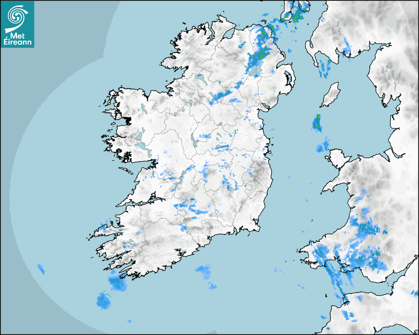

Latest Rainfall Radar showing live precipitation and the last 90 minutes precipitation over Ireland, updated every 5 minutes. Precipitation can be rain, hail or snow. Accumulations can refer to rainfall only.
Lightning strikes, when they occur, are displayed as a cross. Initially, they are red but change to orange and then yellow after a period, then disappear © Met Office ATDNet.
Ground Clutter may appear (South Co. Dublin), bright bands and spokes may also be present in images. They are artefacts (false echoes) of rainfall radar systems and should be ignored. Further information on Radar here
Met Éireann forecasters manually produce the weather icons for midday and midnight to reflect the predicted major weather type for these times.
The rainfall forecast is direct model output from Numerical Weather Prediction models but is a guideline only. Rain refers to precipitation, which can be rain, sleet or snow. It forecasts how much rain will fall (in mm) hourly during the previous hour (accumulations), then in 3 hourly and finally 6 hourly accumulations up to 7 days. This service is based on data and products of the HARMONIE-AROME and the European Centre for Medium-range Weather Forecasts (ECMWF) models.
The wind is direct model output from Numerical Weather Prediction models but is a guideline only. It forecasts the strength of the wind (in knots and km/h) at 10m for the top of each hour, in hourly, then 3 hourly and finally 6 hourly intervals up to 7 days. The wind arrow tip points in the direction the wind is blowing and the tail length indicates wind strength. However, in the text forecast below, it is described as where it is blowing from. This service is based on data and products of the HARMONIE-AROME and the European Centre for Medium-range Weather Forecasts (ECMWF) models.
The temperature is direct model output from Numerical Weather Prediction models but is a guideline only. It forecasts air temperature on land and over sea in °C for the top of each hour, 3 hourly and finally 6 hourly intervals up to 7 days. Minus zero (-0) indicates values between 0 to -0.5°C. This service is based on data and products of the HARMONIE-AROME and the European Centre for Medium-range Weather Forecasts (ECMWF) models.
The Mean Sea Level Pressure (MSLP) is direct model output from Numerical Weather Prediction models but is a guideline only. It forecasts the MSLP in hecto Pascals (hPa) for the top of that hour initially in 3 hourly intervals, then 6 hourly. This service is based on data and products of the HARMONIE-AROME and the European Centre for Medium-range Weather Forecasts (ECMWF) models.
Réamhaisnéis Náisiúnta
01 April 2026 21:00
Anocht
Wet and breezy to begin tonight with outbreaks of rain and drizzle and moderate to fresh south to southwest winds. The rain will give way to clear spells and scattered showers overnight as winds ease and veer westerly. Further outbreaks of rain and drizzle will spread from the southwest towards morning. Lowest temperatures of 3 to 8 degrees.
Amárach
Some sunny spells and scattered showers over the northern half of the country at first on Friday but cloudier further south with outbreaks of rain and drizzle in the southwest spreading northeastwards. Brightening up for most through the afternoon and evening with sunny spells and scattered showers spreading from the west. Highest temperatures of 9 to 14 degrees, mildest in the south, in light to moderate westerly winds, fresher for a time near southern and southwestern coasts.
Met News

02a Aibreán 2026
Climate Statement for March 2026
Mild and sunny. Wet for most, drier in the South M... léigh níos mó

23ú Márta 2026
World Meteorological Day, 2026 - Observing Today, Protecting Tomorrow
State of the Global Climate report issued today as... léigh níos mó

04ú Márta 2026
Climate Statement for Winter 2025/2026
Mild December and February, cool January. Wet in t... léigh níos mó