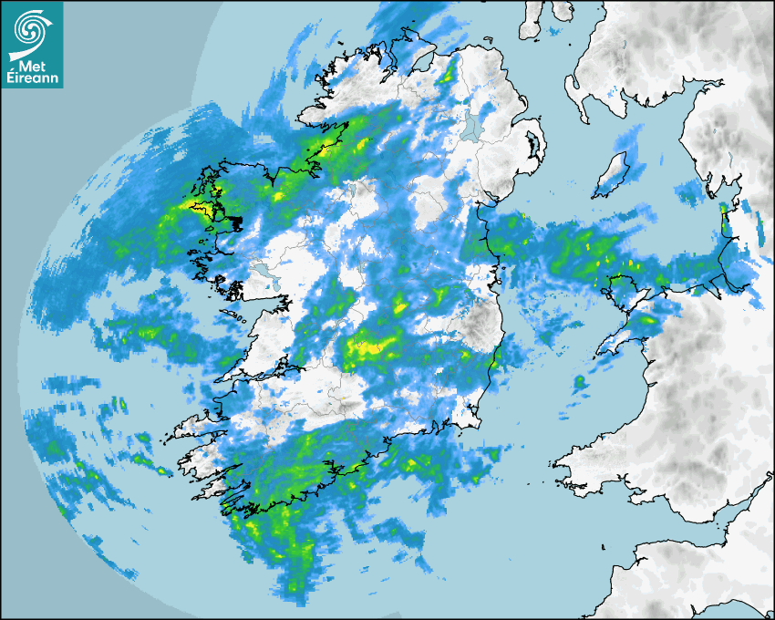

Latest Rainfall Radar showing live precipitation and the last 90 minutes precipitation over Ireland, updated every 5 minutes. Precipitation can be rain, hail or snow. Accumulations can refer to rainfall only.
Lightning strikes, when they occur, are displayed as a cross. Initially, they are red but change to orange and then yellow after a period, then disappear © Met Office ATDNet.
Ground Clutter may appear (South Co. Dublin), bright bands and spokes may also be present in images. They are artefacts (false echoes) of rainfall radar systems and should be ignored. Further information on Radar here
Met Éireann forecasters manually produce the weather icons for midday and midnight to reflect the predicted major weather type for these times.
The rainfall forecast is direct model output from Numerical Weather Prediction models but is a guideline only. Rain refers to precipitation, which can be rain, sleet or snow. It forecasts how much rain will fall (in mm) hourly during the previous hour (accumulations), then in 3 hourly and finally 6 hourly accumulations up to 7 days. This service is based on data and products of the HARMONIE-AROME and the European Centre for Medium-range Weather Forecasts (ECMWF) models.
The wind is direct model output from Numerical Weather Prediction models but is a guideline only. It forecasts the strength of the wind (in knots and km/h) at 10m for the top of each hour, in hourly, then 3 hourly and finally 6 hourly intervals up to 7 days. The wind arrow tip points in the direction the wind is blowing and the tail length indicates wind strength. However, in the text forecast below, it is described as where it is blowing from. This service is based on data and products of the HARMONIE-AROME and the European Centre for Medium-range Weather Forecasts (ECMWF) models.
The temperature is direct model output from Numerical Weather Prediction models but is a guideline only. It forecasts air temperature on land and over sea in °C for the top of each hour, 3 hourly and finally 6 hourly intervals up to 7 days. Minus zero (-0) indicates values between 0 to -0.5°C. This service is based on data and products of the HARMONIE-AROME and the European Centre for Medium-range Weather Forecasts (ECMWF) models.
The Mean Sea Level Pressure (MSLP) is direct model output from Numerical Weather Prediction models but is a guideline only. It forecasts the MSLP in hecto Pascals (hPa) for the top of that hour initially in 3 hourly intervals, then 6 hourly. This service is based on data and products of the HARMONIE-AROME and the European Centre for Medium-range Weather Forecasts (ECMWF) models.
Réamhaisnéis Náisiúnta
02 August 2026 17:30
Inniu
Staying cloudy this evening with further outbreaks of rain and drizzle and a light easterly breeze.
Anocht
Mostly cloudy with outbreaks of rain and drizzle. Much of Leinster will remain largely dry overnight. Temperatures will not fall below 11 to 16 degrees in light to moderate northeasterly winds.
Amárach
Largely cloudy on Bank Holiday Monday with scattered outbreaks of rain and drizzle continuing to affect much of the country. The best of any sunny spells will be towards the east and southeast during the afternoon. Some heavy and possibly thundery downpours will develop towards the evening bringing the chance of surface flooding. Becoming humid with highest temperatures of 18 to 23 degrees in light to moderate southeasterly winds.
Met News

02a Iúil 2026
Climate Statement for June 2026
Warm and wet. Heat dome brought heatwaves and exce... léigh níos mó

26ú Meitheamh 2026
139th Anniversary of Ireland’s hottest day
139th Anniversary of Ireland’s hottest day – 3... léigh níos mó

22ú Meitheamh 2026
A look back at the summer of 1976
The summer of 1976 is remembered in Ireland and th... léigh níos mó