Meteorologist’s Commentary by Evelyn Cusack, Head of forecasting, Met Éireann Tuesday, 18th August 2020
Met Éireann has named Storm Ellen for disruptive and potentially damaging winds Wednesday evening (19th) and throughout Thursday (20th). Due to the combination of storm surge, spring tides and onshore winds there is a risk of some coastal flooding. There is a risk also of some inland and river flooding with some potentially heavy, thundery downpours.
Status Orange/Yellow wind warnings are in effect for the Island of Ireland and will be updated Wednesday morning. Orange level impacts may potentially occur over any part of the Island and tourists in exposed locations in particular will be at risk for these unseasonable stormy and wet conditions. Please sign up for warnings notifications on the Met Éireann app and get the latest warnings https://www.met.ie/warnings and www.metoffice.gov.uk
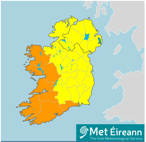
Figure 1: Warnings for Ireland issued Tuesday 18/08/2020 for Wednesday/Thursday
Storm Ellen is forming over the Atlantic fuelled by the remnants of Hurricane Kyle as shown here in Figure 2 which is a display of Airmass temperature and satellite imagery from the European satellite, Meteosat.
Figure 2: A large circulation in mid-Atlantic fuelled by the interaction of the remnants of hurricane Kyle and the jet-stream.
Ellen is forecast to move over the southwest of Ireland Wednesday evening, tracking northwards over the country during Wednesday night and daytime Thursday. Gusts generally of 80 to 100km/h can be expected and potentially gusts may exceed 130km/h in some exposed coastal and mountain locations and some lower locations due to funnelling effects.
https://www.met.ie/forecasts/atlantic-charts/precipitation-pressure
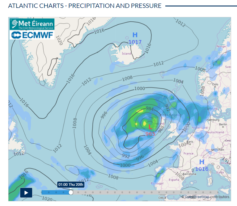
Figure 3: Storm Ellen is forecast to track in over Ireland from the Atlantic
There is still a high degree of uncertainty in the exact track of the storm and there is a considerable spread in possibilities over Ireland with some models indicating that the east may get the strongest winds. The warnings will be updated Wednesday morning but here is the 18Z run of the Met Éireann high-resolution model, HARMONIE. It is an ensemble prediction system (IREPS) with 11 different possible tracks and outcomes. Orange level impacts may potentially occur over any part of the Island.
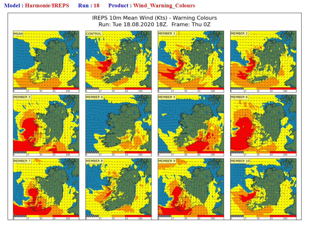
Figure 4: Met Éireann’s high-resolution Ensemble Prediction System (IREPS) showing the range of possibilities of the severe winds.
With trees in full leaf and peak numbers on holidays in Ireland, impacts could be significant with damaging winds, heavy rain, and large waves along the coast. Strong winds overland, high, potentially dangerous, waves can occur on lakes as well as along coasts and over high ground.
Storm Ellen is the fifth named storm from the Met Éireann, UKMO and KNMI storm list of 2019/2020. It is the sixth named storm overall as the first one, storm Lorenzo, was named by the National hurricane Center. Lorenzo originated as Hurricane Lorenzo, the eastern most and northern most category 5 hurricane ever recorded in the Atlantic Ocean but weakenend considerably as it stalled off the northwest coast and produced few impacts as it tracked over Ireland on Friday October4th 2019.
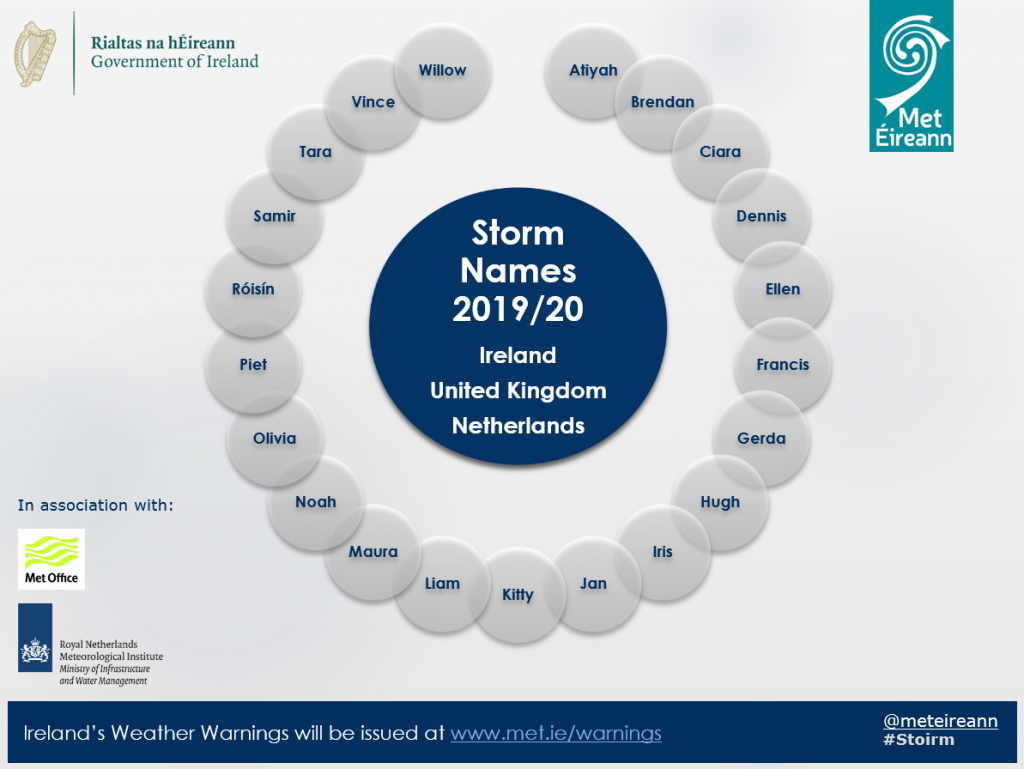
Figure 5: Storm names for 2019/2020 season
Figure 6 is the Storm naming form Met Éireann shared with its partners the UK Met Office and KNMI, the Dutch Meteorological Service in the West group and the Southwest group consisting of Portugal, Spain, France and Belgium when we named Storm Ellen.
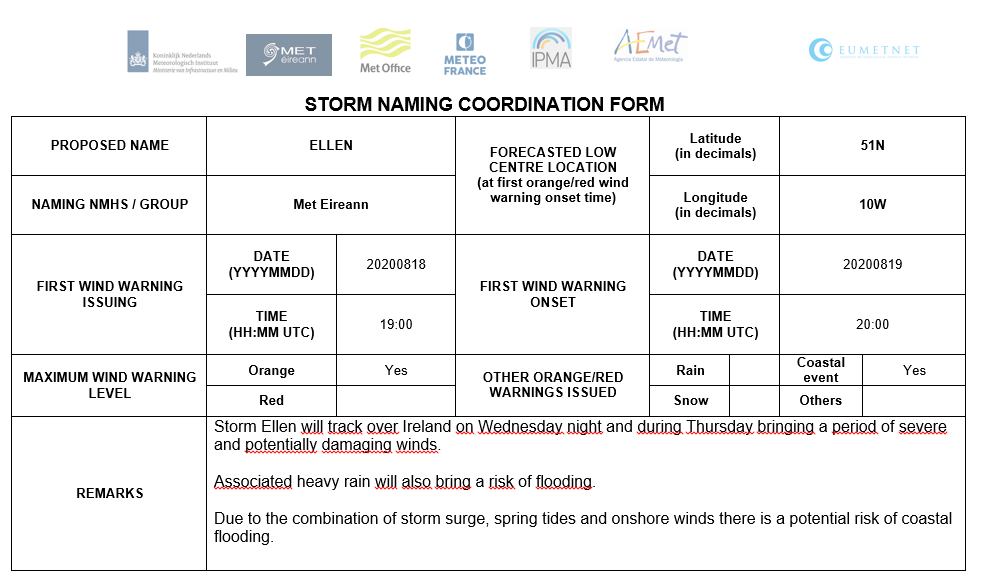
Figure 6: Storm Naming Form for Storm Ellen
Updates will be issued Wednesday morning. Extreme caution is advised.
https://www.met.ie/forecasts/marine-inland-lakes/sea-area-forecast