Tá ardbhrú agus gaotha an oirthir ag cur le meánteochtaí dromchla na farraige (TDFanna) míosúla timpeall chóstaí na hÉireann a bheith idir 0.6 agus 2.2°C níos airde ná an meán don am seo den bhliain.
Bhí Teochtaí Dromchla na Farraige (TDFanna) feadh chóstaí thiar agus theas na hÉireann i bhfad os cionn an mheáin i rith mhí na Bealtaine 2025.
Léiríonn sonraí breathnóireachta sealadacha ó Líonra Breathnóireachta Baoithe Sonraí Muirí na hÉireann (LBBSMÉ) ), atá á bhainistiú ag Foras na Mara i gcomhar le Met Éireann, go bhfuil TDFanna ag ardú go seasta i rith na míosa.
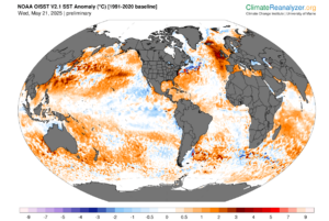
Fíor 1 – Taispeánann léarscáil aimhrialtachta teochta dromchla farraige domhanda teochtaí dromchla na farraige amach ó chósta thiar na hÉireann atá i bhfad os cionn bhunlíne 1991-2020..
Cé go bhfuil tonnta teasa mara ag tarlú i réigiúin éagsúla ar fud an domhain (Fíor 1), tá na aimhrialtachtaí atá thar a bheith ard san Atlantach Thuaidh thoir—amach ó chósta thiar na hÉireann—suntasach. Is é an príomhchúis leis an téamh lóganta seo ná córas ardbhrú leanúnach a bhí i gceannas i bpatrúin aimsire thar iarthuaisceart na hEorpa le linn an earraigh. Bhí na dálaí seo—spéartha soiléire, gaotha éadroma, agus sreafaí te soir – thar a bheith fabhrach do théamh tapa dromchla sa chuid seo den aigéan. In áiteanna eile, ní raibh socruithe comhchosúla chomh seasta ná chomh dian, rud a chabhraíonn le míniú a thabhairt ar an gcúis nach bhfuil an aimhrialtacht le feiceáil ar fud an Atlantaigh níos leithne. Is féidir le suíomh agus marthanacht patrún atmaisféaracha mar seo codarsnachtaí géara réigiúnacha a chruthú, fiú i gcoinne chúlra teochtaí aigéin atá ag ardú go domhanda. Déantar comparáid idir na aimhrialtachtaí agus an bonnlíne is déanaí ó 1991-2020, rud a chiallaíonn nach bhfuil siad chomh soiléir agus a bheadh siad i gcomparáid le bonnlíne níos luaithe, níos fuaire.
Faoi lár mhí na Bealtaine, bhí teochtaí ag roinnt bhaoi LBBSMÉ níos mó ná 1°C os cionn an mheáin mhíosúil cheana féin (Fíor 2). Le seachtain fágtha sa mhí, is dócha go mbeidh na meáin mhíosúla deiridh níos airde fós.
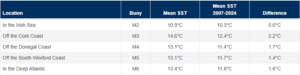
Fíor 2 – Meánteocht dhromchla na farraige LBBSMÉ do mhí na Bealtaine go dtí seo (22 Bealtaine 2025)
Leanann an téamh seo treocht a breathnaíodh le déanaí. Chonaic Aibreán 2025 meán-TDFanna míosúla taifeadta ag trí cinn de na cúig shuíomh bhaoi:
- Thaifead M4 11.32 °C (os cionn thaifead mhí Aibreáin 2011 de 10.74°C).
- Shroich M2 9.69 °C (ag sárú thaifead mhí Aibreáin 2024 de 9.65 °C),
- Shroich M3 11.99 °C (ag sárú an ardteocht roimhe sin i mí Aibreáin de 11.91 °C ó 2007),
- Bunaithe ar shonraí reatha, tá M3 ar an mbóthar ceart chun a thaifead a bhriseadh i mí na Bealtaine chomh maith (Fíor 3).
Deir Paul Moore, Clíomeolaí Met Éireann, “Is iad na TDFanna arda is cúis den chuid is mó le limistéar leanúnach ardbhrú ó thuaidh na hÉireann agus na Ríochta Aontaithe i rith an earraigh. Mar gheall ar an bpatrún seo, tá spéartha glana, taitneamh gréine os cionn an mheáin, agus luasanna gaoithe laghdaithe. Tá gaotha anoir, nach mbíonn tipiciúil don tráth seo den bhliain, tar éis cur le téamh tapa uiscí dromchla amach ó chóstaí thiar agus theas na farraige trí mheascadh na farraige a theorannú agus aer níos teo a iompar ón talamh amach go dtí an fharraige.”
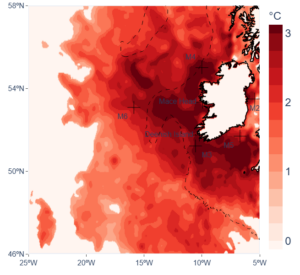
Fíor 3: Aimhrialtachtaí Teochta Dhromchla na Farraige ar an 22 Bealtaine 2025 (ó Uirlis Monatóireachta Tonnta Teasa Mara Fhoras na Mara).).
Bhí dálaí meitéareolaíochta comhchosúla i láthair i mBealtaine agusi mí an Mheithimh 2023, roimh an Meitheamh is teo riamh in Éirinn.
Léirigh taighde gur féidir le tonnta teasa mara cumhdach scamall a laghdú os cionn na farraige agus báisteach chomhiomprach a mhéadú os cionn talún mar gheall ar ghaotha mara níos teo agus níos taise. Léiríonn sé seo réamh-mheastacháin níos leithne maidir leis an aeráid a léiríonn gur féidir le hatmaisféar níos teo 7% níos mó taise a shealbhú in aghaidh gach céime téimh, rud a d’fhéadfadh a bheith ina chúis le himeachtaí báistí níos déine.
Cé gur aimsir thirim a bhí ann den chuid is mó an t-earrach seo mar gheall ar an ardbhrú ceannasach, d’fhéadfadh teochtaí te na farraige cur le déine báistí méadaithe má athraíonn dálaí atmaisféaracha. Táthar ag súil le hathrú san aimsir sna laethanta amach romhainn, agus gaotha níos láidre ón iarthar, ag teacht ón Atlantach, á dtuar go bhfillfidh siad. Ba cheart go gcuideodh na gaotha seo le huisce níos fuaire faoin dromchla a mheascadh leis an tsraith dromchla te, rud a d’fhéadfadh laghdú a dhéanamh ar TDFanna, ar a laghad go sealadach. Mar sin féin, is taiscumair theirmeach mallghluaiseachta é an t-aigéan i gcomparáid leis an atmaisféar, mar sin d’fhéadfadh sé go dtógfadh sé tamall ar éifeachtaí fuaraithe tarlú, agus is dócha nach mbeidh siad soiléir go dtí deireadh na míosa.
Ar fud an domhain, is comhartha soiléir ar athrú aeráide iad teochtaí na farraige atá ag ardú. De réir mar a théann an t-atmaisféar agus na haigéin i dtéamh, meastar go méadóidh líon agus fad na dtonnta teasa mara. Is féidir leis na himeachtaí seo tionchair mhóra éiceolaíocha a bheith acu, lena n-áirítear bánú coiréil, athruithe i speicis mhuirí, bláthan algaí díobhálacha, agus cur isteach ar shlabhraí bia. Cé gur tharla tonnta teasa mara le déanaí timpeall na hÉireann lasmuigh den tréimhse tipiciúil buaic-TDF i mí Lúnasa, d’fhéadfadh imeachtaí amach anseo a ailíníonn leis an gcuid is teo den bhliain strus níos mó a chur ar éiceachórais mhuirí.
Nótaí don léitheoir:
Éist le Paul Moore, Clíomeolaí Met Éireann, ar raidió RTÉ ag míniú Tonn Teasa Muirí Bhealtaine 2025: https://www.rte.ie/radio/radio1/clips/22515270/
Déantar sonraí TDF ón LBBSMÉ a recorded hourly agus déanann Foras na Mara agus Met Éireann monatóireacht ghéar orthu. e haghaidh tuilleadh eolais agus sonraí tonn teasa mara fíor-ama, tabhair cuairt ar: https://www.marine.ie/site-area/data-services/remote-sensing/marine-heat-waves
Tonn Teasa Muirí Meitheamh 2023: Ghinigh dálaí atmaisféaracha eisceachtúla i mí an Mheithimh 2023 tonn teasa muirí in iarthuaisceart na hEorpa a chuir le briseadh taifid teochta talún | Cumarsáid Domhan & Comhshaol
Tonnta Teasa Muirí agus Athrú Aeráide: Tonn Teasa Muirí 2023 – Rabhadh don Todhchaí – Met Éireann – Seirbhís Meitéareolaíochta na hÉireann