Coinníollacha athraitheacha thar dheireadh seachtaine na Cásca le drochaimsir shuaiteach, go háirithe ar an Satharn.
Nuashonraithe 02/04/2026 —————— ———————–
Intreoir
Tá comhairle aimsire i bhfeidhm do dheireadh seachtaine iomlán na Cásca agus muid ag bogadh isteach i bpatrún an-ghníomhach Atlantaigh. Beidh an aimsir athraitheach, le tréimhsí gaofar nó an-ghaofar agus báisteach ag amanna, chomh maith le luaineachtaí teochta. Táimid i dtréimhse taoidí earraigh, agus mar sin d’fhéadfadh na hardtaoidí, i gcomhar le borradh stoirme agus gaotha láidre ón gcósta, a bheith ina gcúis le tonnta ag dul thar chosaintí cósta agus le tuilte i gceantair ísle agus nochta.
Beidh an tréimhse ghaoithe is suaithinsí tráthnóna Dé Sathairn agus isteach san oíche, nuair a thiocfaidh rabhadh gaoithe Buí náisiúnta i bhfeidhm. Tá baol ann go mbeidh séideáin an-láidir de réir mar a rachaidh Stoirm Dave thar chóstaí an iarthair agus an iarthuaiscirt. D’ainmnigh Oifig Met na Ríochta Aontaithe Stoirm Dave maidin Déardaoin, agus tá coinníollacha níos stoirmiúla á dtuar d’Albain oíche Dé Sathairn.
Leagan Achoimre
Tá Sruth Scairde an Atlantaigh Thuaidh an-láidir faoi láthair mar gheall ar an gcodarsnacht mhéadaithe idir aer fuar ag teacht anuas ón iarthuaisceart agus aer níos séimhe ag gluaiseacht suas ón iardheisceart. Cuirfidh an Sruth Scairde an-ghníomhach seo le forbairt agus le doimhniú tapa limistéar brú íseal a rachaidh gar d’Éirinn agus don Ríocht Aontaithe, nó tharstu, i rith an deireadh seachtaine. Tosóidh an córas lagbhrú is suntasaí, Stoirm Dave, ag forbairt san Atlantach siar ó dheas d’Éirinn oíche Dé hAoine. Déanfaidh sé cioglaighineas thapa agus é ag bogadh soir ó thuaidh feadh chóstaí an iarthair agus an iarthuaiscirt Dé Sathairn, agus leanfaidh sé ag doimhniú agus é ag gluaiseacht isteach in Albain oíche Dé Sathairn. Ós rud é nach bhfuil an stoirm forbartha go hiomlán fós, tá éiginnteacht ann fós maidir lena doimhneacht, a conair agus, dá bhrí sin, neart na gaoithe. Forbróidh réimse eile lagbhrú gar d’oirdheisceart na hÍoslainne Dé Luain, rud a fhágfaidh lá gaofar in Éirinn.
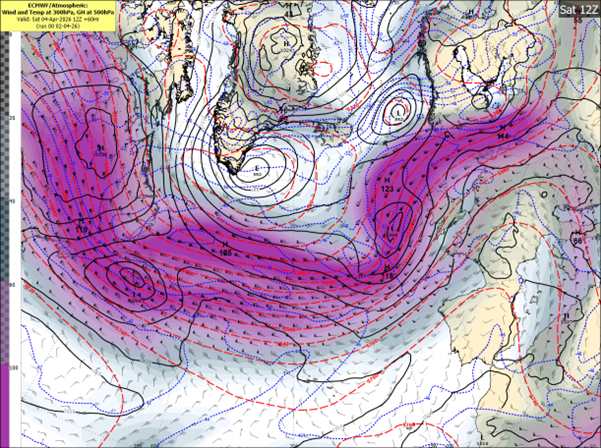
Fíor 1 Samhail Lárionaid Eorpach do Réamhaisnéisí Aimsire Meánraoin (ECMWF) ag taispeáint grádán láidir teochta
Dé hAoine, 3 Aibreán (Aoine an Chéasta)
Beidh sé scamallach ar feadh tamaill le báisteach éadrom, ceobhrán nó cith. Tiocfaidh feabhas san iarnóin de réir mar a ghlanfaidh an bháisteach agus an ceobhrán, agus beidh tréimhsí gréine le ceathanna scaipthe ina ndiaidh. Beidh sé beagán gaofar uaireanta, go háirithe feadh chóstaí an deiscirt agus an iarthair.
Dé Sathairn, 4 Aibreán
Tosóidh réimse lagbhrú ag forbairt amach san Atlantach oíche Dé hAoine agus forbróidh sé ina Stoirm Dave de réir mar a dhéanfaidh sé cioglaighineas tapa i réigiún iontrála dheis an tsrutha scairde. Bogfaidh sé soir ó thuaidh i dtreo chóstaí an iarthair agus an iarthuaiscirt d’Éirinn níos déanaí Dé Sathairn agus leanfaidh sé ag doimhniú de réir mar a ghluaiseann sé isteach in Albain oíche Dé Sathairn. Neartóidh gaotha ó dheas de réir a chéile i rith an tráthnóna, ag casadh siar níos déanaí. Beidh rabhadh gaoithe buí náisiúnta i bhfeidhm ó 2pm go dtí 11pm. Beidh na gaotha is láidre san iarthuaisceart. Má athraíonn suíomh nó déine réamhaisnithe Stoirm Dave, d’fhéadfaí na rabhaidh a nuashonrú, agus tá seans beag ann go n-ardófaí rabhadh Dhún na nGall go leibhéal oráiste ar feadh tréimhse. Tabharfaidh Stoirm Dave tréimhsí báistí léi freisin. D’fhéadfadh taoidí arda réalteolaíocha (Taoidí Earraigh), i gcomhar le borradh stoirme, airde suntasach tonn agus gaotha láidre go gaotha stoirme ón gcósta, tonnta a chur thar chosaintí cósta agus tuilte cósta a chruthú ag amanna na hardtaoide. Is iad na limistéir feadh chóstaí an Atlantaigh is leochailí.
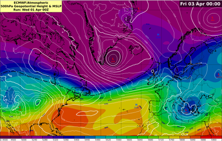
Fíor 2 Samhail ECMWF ag taispeáint an tsrutha scairde agus an bhrú aeir ar an Satharn – Stoirm Dave forbartha siar ó Éirinn
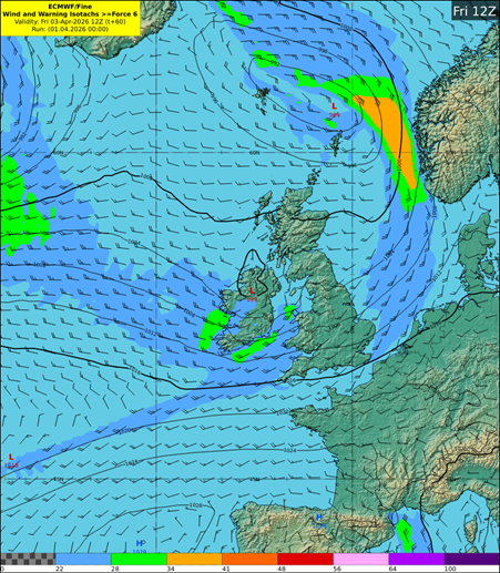
Fíor 3 Samhail DINI ag taispeáint na luasanna gaoithe réamhaisnithe do 7pm Dé Sathairn
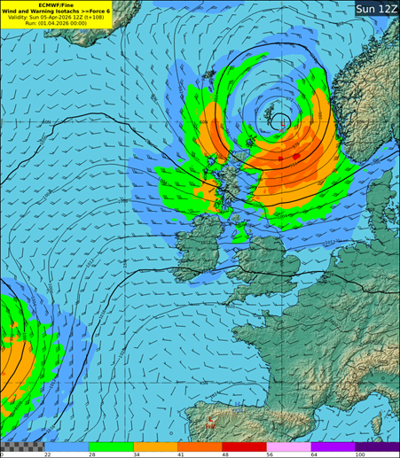
Fíor 4 Samhail DINI ag taispeáint na frasaíochta réamhaisnithe tráthnóna Dé Sathairn
Domhnach, 5 Aibreán (Domhnach Cásca)
Beidh sé gaofar ar feadh tamaill le tréimhsí gréine agus ceathanna scaipthe. Beidh sé níos fuaire freisin agus titfidh cuid de na ceathanna mar chlocha sneachta agus mar fhlichshneachta ar thalamh ard, go háirithe san iarthar agus sa tuaisceart. Tá seans ann go mbeidh beagán sneachta ar chnoic níos faide ó thuaidh go luath ar maidin. D’fhéadfadh gaotha úra go láidre ón iarthar go luath Dé Domhnaigh, i gcomhar le tonnta arda, tonnta a chur thar chosaintí cósta agus tuilte a chruthú i gceantair ísle agus nochta. Tiocfaidh feabhas de réir a chéile i rith an lae de réir mar a mhaolóidh na gaotha agus a éireoidh na ceathanna níos scaipthe. Mar thoradh air sin beidh tráthnóna tirim, grianmhar Domhnach Cásca le gaotha níos séimhe.
Dé Luain, 6 Aibreán
Beidh lá gaofar ann ach beidh sé níos séimhe agus ní bheidh ach beagán báistí agus ceobhráin ann.
RABHAIDH AGUS TIONCHAIR: Tá na rabhaidh seo a leanas eisithe ag Met Éireann (amhail 3pm, Déardaoin, an 2 Aibreán):
Tá Rabhadh Gaoithe Buí eisithe ar fud na tíre mar gheall ar Stoirm Dave.
Tabharfaidh Stoirm Dave gaotha an-láidre ó dheas, a chasfaidh siar faoin tráthnóna, le séideáin throma agus galaí cósta.
Tionchair fhéideartha:
Roinnt crann agus craobhacha tite
Scaileogú
Coinníollacha taistil deacra
Smionagar agus réada scaoilte díláithrithe
D’fhéadfaí na rabhaidh a nuashonrú de réir mar a dhéanfar anailís ar rithí nua na samhlacha agus de réir mar a mhéadóidh an chinnteacht.
Coinnigh súil ar réamhaisnéisí Met Éireann agus / nó tabhair cuairt ar https://www.met.ie/ le haghaidh na faisnéise is déanaí. Bíonn eolas ar fáil ar fud ardáin na meán sóisialta agus foinsí meán nuachta eile
Tá baol ann go mbeidh tuilte cósta ann, go háirithe timpeall amanna na hardtaoide agus i gceantair ísle nochta feadh chóstaí an Atlantaigh
Méadóidh taoidí arda réalteolaíocha (Taoidí Earraigh), i gcomhar le borradh stoirme agus gaotha leanúnacha ón gcósta, an baol tuilte cósta tuilleadh. Tá limistéir feadh chóstaí an iarthair agus an tuaiscirt go háirithe leochaileach
D’fhéadfadh gaotha láidre ón gcósta agus tonnta arda tonnta a chur thar chosaintí cósta agus tuilte a chruthú i gceantair ísle agus nochta
Má tá tú ag taisteal achair fhada, seiceáil na coinníollacha aimsire agus bóthair ní hamháin ag do phointe imeachta ach ag do cheann scríbe agus feadh an bhealaigh freisin, mar d’fhéadfadh coinníollacha athrú go suntasach
Is féidir teagmháil a dhéanamh le Seirbhísí Éigeandála BSL ag 1800 372 999. Is féidir leis an bpobal súil a choinneáil ar PowerCheck.ie
CÉN FÁTH AGUS CONAS A AINMNÍTEAR STOIRMEACHA?
Ainmnítear stoirmeacha nuair a d’fhéadfadh siad tionchair ‘mheasartha’ nó ‘arda’ a bheith i gceann de na trí thír chomhpháirtíochta. Cumasaíonn sé seo teachtaireachtaí comhsheasmhacha agus údarásacha don phobal agus do pháirtithe leasmhara eile le cur ar a gcumas ullmhú agus fanacht sábháilte le linn tarluithe adhaimsire.
Ó 2015 i leith, tá Met Éireann agus Oifig Mheitéareolaíochta na Ríochta Aontaithe ag obair le chéile ar an gclár ainmniúcháin agus tháinig KNMI na hÍsiltíre leo i 2019 chun ‘grúpa an iarthair’ de sheirbhísí aimsire na hEorpa a fhoirmiú.
Nuair a fhógraítear stoirm, ainmníonn an tseirbhís náisiúnta aimsire a bhíonn ag súil leis an tionchar is mó ón aimsir chrua ar a réigiún nó is mó is dócha a bheidh buailte, an stoirm. Tarlaíonn ainmniú stoirme in éineacht le rabhaidh oráiste/dhearga, a d’fhéadfadh a bheith ann don ghaoth, don bháisteach nó don sneachta nó do mheascán díobh seo. Éisítear na rabhaidh, dá réir sin, bunaithe ar mheascán de thairseacha uimhriúla agus na tionchair fhéideartha a mheastar.
CONAS A ROGHNAÍTEAR AINMNEACHA STOIRMEACHA?
Foilsíonn Met Éireann, Oifig na Meitéareolaíochta na Ríochta Aontaithe agus KNMI liosta nua d’ainmneacha stoirme do gach séasúr stoirme, a thosaíonn an 1 Meán Fómhair.
Don séasúr 2025/26, chuir gach ceann de na trí sheirbhís meitéareolaíochta seacht n-ainm leis an liosta séasúir. D’iarr Met Éireann ar mhuintir na hÉireann a rogha ainmneacha a chur isteach trí fheachtas ar na meáin shóisialta. Fuarthas níos mó ná 10,000 ainm ó 4,137 duine den phobal.
Seo a leanas an liosta iomlán d’ainmneacha shéasúr 2025/26: Amy, Bram, Chandra, Dave, Eddie, Fionnuala, Gerard, Hannah, Isla, Janna, Kasia, Lilith, Marty, Nico, Oscar, Patrick, Ruby, Stevie, Tadhg, Violet, Wubbo.
Fíor 5 – Liosta Ainmneacha Stoirmeacha 2025/26
(Tá na hainmneacha a roghnaigh Met Éireann i gcló trom. Níl na litreacha Q, U, X, Y, Z san áireamh, tá sé seo ag teacht le gnás ainmnithe Lárionad Náisiúnta Hairicín na SA).
Foilsithe 01/04/2026 ——————— ———————–
Aimsir athraitheach thar dheireadh seachtaine na Cásca, le neamhchinnteacht sna sonraí
Intreoir
Tar éis seachtain a bhí níos tirime ná an gnáthleibhéal, meastar go dtiocfaidh meath ar an aimsir, le tréimhsí báistí, gaofar agus b’fhéidir stoirmiúil le teacht. Tá foláireamh aimsire eisithe mar gheall ar an mbaol aimsire suaithinseach, chomh maith le méadú ar nochtadh de bharr daoine a bheith ag taisteal don deireadh seachtaine fada Cásca agus tréimhse taoide earraigh. D’fhéadfadh gaotha láidre ón gcósta agus tonnta arda tonnta a chur thar chosaintí cósta agus tuilte a chruthú i gceantair ísle agus nochta. Tá neamhchinnteacht sna sonraí faoi láthair agus leanfaidh Met Éireann orthu ag monatóireacht ar an staid agus ag eisiúint nuashonruithe de réir mar a thagann soiléireacht.
Leagan Achoimre
Tá sraith lagbhrú ag bogadh gar d’Éirinn agus don Ríocht Aontaithe, ag dul i neart de réir a chéile. Tá an Scairdshruth le neartú agus le bogadh thar an tír, á spreagadh ag difríocht mhéadaithe teochta idir aer fuar ón iarthuaisceart agus aer níos séimhe ón iardheisceart. Tagann an neamhchinnteacht as an bhfíric nach bhfuil na córais seo lánfhorbartha fós, agus go bhféadfadh fiú athrú beag ina suíomh tionchar mór a imirt ar neart na ngaoth agus ar dhéine na stoirme.
Fíor 1 Samhail Lárionaid Eorpach do Réamhaisnéisí Aimsire Meánraoin (ECMWF) ag taispeáint grádán láidir teochta
Fíor 2 Samhail ECMWF ag taispeáint an Scairdshruth ag neartú os cionn na hÉireann
Dé hAoine, 3 Aibreán (Aoine an Chéasta)
Meastar go n-éireoidh sé gaofar, go háirithe níos déanaí ar maidin agus tráthnóna luath, de réir mar a ghluaiseann ísealbhrú forbartha trasna na tíre. Tugann an treoir reatha le fios nach meastar go mbeidh doimhniú pléascach ann, ach d’fhéadfadh gaotha láidre agus tréimhsí ceathanna báistí a bheith ann.
Fíor 3 Samhail ECMWF ag taispeáint na luasanna gaoithe tuartha Dé hAoine
Fíor 4 Samhail ECMWF ag taispeáint frasaíocht tuartha Dé hAoine
Dé Sathairn, 4 Aibreán
Lá fliuch agus gaofar le tréimhsí báistí, trom in amanna, agus seans tuilte áitiúla. D’fhéadfadh gaotha an-láidre ón iardheisceart forbairt níos déanaí sa lá, go háirithe in áiteanna san iarthar agus san iarthuaisceart. Méadóidh taoidí arda réalteolaíocha (Taoidí Earraigh), i gcomhar le borradh stoirme agus gaotha leanúnacha ón gcósta, an baol tuilte cósta tuilleadh. Tá limistéir feadh chóstaí an iarthair agus an tuaiscirt go háirithe leochaileach.
Fíor 5 Samhail ECMWF ag taispeáint na luasanna gaoithe tuartha Dé Sathairn
Fíor 6 Samhail ECMWF ag taispeáint frasaíocht tuartha Dé Sathairn
Domhnach, 5 Aibreán (Domhnach Cásca)
Lá measartha gaofar le ceathanna. Beidh sé níos fuaire freisin, agus titfidh cuid de na cithfholcadáin mar fhlichshneachta, go príomha san iarthar agus sa tuaisceart, agus tá seans ann go mbeidh sneachta ar thalamh ard. D’fhéadfadh go mbeadh scaileogú agus tuilte a chruthú i gceantair ísle agus nochta mar gheall ar ghaotha láidre ón iarthar go luath Dé Domhnaigh, i gcomhar le tonnta arda.
Fíor 7 Samhail ECMWF ag taispeáint na luasanna gaoithe tuartha Dé Domhnaigh
Fíor 8 Samhail ECMWF ag taispeáint frasaíocht tuartha Dé Domhnaigh
Dé Luain, 6 Aibreán
D’fhéadfadh lá gaofar eile a bheith ann, ach tugann na réamhaisnéisí reatha le fios go bhfanfaidh an ghaoth agus an bháisteach is measa amach ón gcósta.
Fíor 9 Samhail ECMWF ag taispeáint na luasanna gaoithe tuartha Dé Luain
Fíor 10 Samhail ECMWF ag taispeáint frasaíocht tuartha Dé Luain
Teachtaireachtaí Sábháilteachta Poiblí
Coinnigh súil ar réamhaisnéisí Met Éireann agus / nó tabhair cuairt ar https://www.met.ie/ le haghaidh na faisnéise is déanaí. Bíonn eolas ar fáil ar fud ardáin na meán sóisialta agus foinsí meán nuachta eile
Tá baol ann go mbeidh tuilte cósta ann, go háirithe timpeall amanna na hardtaoide agus i gceantair ísle nochta feadh chóstaí an Atlantaigh
Méadóidh taoidí arda réalteolaíocha (Taoidí Earraigh), i gcomhar le borradh stoirme agus gaotha leanúnacha ón gcósta, an baol tuilte cósta tuilleadh. Tá limistéir feadh chóstaí an iarthair agus an tuaiscirt go háirithe leochaileach
D’fhéadfadh gaotha láidre ón gcósta agus tonnta arda tonnta a chur thar chosaintí cósta agus tuilte a chruthú i gceantair ísle agus nochta
Má tá tú ag taisteal achair fhada, seiceáil na coinníollacha aimsire agus bóthair ní hamháin ag do phointe imeachta ach ag do cheann scríbe agus feadh an bhealaigh freisin, mar d’fhéadfadh coinníollacha athrú go suntasach
Is féidir teagmháil a dhéanamh le Seirbhísí Éigeandála BSL ag 1800 372 999. Is féidir leis an bpobal súil a choinneáil ar PowerCheck.ie
Coinníollacha athraitheacha thar dheireadh seachtaine na Cásca le drochaimsir shuaiteach, go háirithe ar an Satharn.
Nuashonraithe 02/04/2026 —————— ———————–
Intreoir
Tá comhairle aimsire i bhfeidhm do dheireadh seachtaine iomlán na Cásca agus muid ag bogadh isteach i bpatrún an-ghníomhach Atlantaigh. Beidh an aimsir athraitheach, le tréimhsí gaofar nó an-ghaofar agus báisteach ag amanna, chomh maith le luaineachtaí teochta. Táimid i dtréimhse taoidí earraigh, agus mar sin d’fhéadfadh na hardtaoidí, i gcomhar le borradh stoirme agus gaotha láidre ón gcósta, a bheith ina gcúis le tonnta ag dul thar chosaintí cósta agus le tuilte i gceantair ísle agus nochta.
Beidh an tréimhse ghaoithe is suaithinsí tráthnóna Dé Sathairn agus isteach san oíche, nuair a thiocfaidh rabhadh gaoithe Buí náisiúnta i bhfeidhm. Tá baol ann go mbeidh séideáin an-láidir de réir mar a rachaidh Stoirm Dave thar chóstaí an iarthair agus an iarthuaiscirt. D’ainmnigh Oifig Met na Ríochta Aontaithe Stoirm Dave maidin Déardaoin, agus tá coinníollacha níos stoirmiúla á dtuar d’Albain oíche Dé Sathairn.
Leagan Achoimre
Tá Sruth Scairde an Atlantaigh Thuaidh an-láidir faoi láthair mar gheall ar an gcodarsnacht mhéadaithe idir aer fuar ag teacht anuas ón iarthuaisceart agus aer níos séimhe ag gluaiseacht suas ón iardheisceart. Cuirfidh an Sruth Scairde an-ghníomhach seo le forbairt agus le doimhniú tapa limistéar brú íseal a rachaidh gar d’Éirinn agus don Ríocht Aontaithe, nó tharstu, i rith an deireadh seachtaine. Tosóidh an córas lagbhrú is suntasaí, Stoirm Dave, ag forbairt san Atlantach siar ó dheas d’Éirinn oíche Dé hAoine. Déanfaidh sé cioglaighineas thapa agus é ag bogadh soir ó thuaidh feadh chóstaí an iarthair agus an iarthuaiscirt Dé Sathairn, agus leanfaidh sé ag doimhniú agus é ag gluaiseacht isteach in Albain oíche Dé Sathairn. Ós rud é nach bhfuil an stoirm forbartha go hiomlán fós, tá éiginnteacht ann fós maidir lena doimhneacht, a conair agus, dá bhrí sin, neart na gaoithe. Forbróidh réimse eile lagbhrú gar d’oirdheisceart na hÍoslainne Dé Luain, rud a fhágfaidh lá gaofar in Éirinn.

Fíor 1 Samhail Lárionaid Eorpach do Réamhaisnéisí Aimsire Meánraoin (ECMWF) ag taispeáint grádán láidir teochta
Dé hAoine, 3 Aibreán (Aoine an Chéasta)
Beidh sé scamallach ar feadh tamaill le báisteach éadrom, ceobhrán nó cith. Tiocfaidh feabhas san iarnóin de réir mar a ghlanfaidh an bháisteach agus an ceobhrán, agus beidh tréimhsí gréine le ceathanna scaipthe ina ndiaidh. Beidh sé beagán gaofar uaireanta, go háirithe feadh chóstaí an deiscirt agus an iarthair.
Dé Sathairn, 4 Aibreán
Tosóidh réimse lagbhrú ag forbairt amach san Atlantach oíche Dé hAoine agus forbróidh sé ina Stoirm Dave de réir mar a dhéanfaidh sé cioglaighineas tapa i réigiún iontrála dheis an tsrutha scairde. Bogfaidh sé soir ó thuaidh i dtreo chóstaí an iarthair agus an iarthuaiscirt d’Éirinn níos déanaí Dé Sathairn agus leanfaidh sé ag doimhniú de réir mar a ghluaiseann sé isteach in Albain oíche Dé Sathairn. Neartóidh gaotha ó dheas de réir a chéile i rith an tráthnóna, ag casadh siar níos déanaí. Beidh rabhadh gaoithe buí náisiúnta i bhfeidhm ó 2pm go dtí 11pm. Beidh na gaotha is láidre san iarthuaisceart. Má athraíonn suíomh nó déine réamhaisnithe Stoirm Dave, d’fhéadfaí na rabhaidh a nuashonrú, agus tá seans beag ann go n-ardófaí rabhadh Dhún na nGall go leibhéal oráiste ar feadh tréimhse. Tabharfaidh Stoirm Dave tréimhsí báistí léi freisin. D’fhéadfadh taoidí arda réalteolaíocha (Taoidí Earraigh), i gcomhar le borradh stoirme, airde suntasach tonn agus gaotha láidre go gaotha stoirme ón gcósta, tonnta a chur thar chosaintí cósta agus tuilte cósta a chruthú ag amanna na hardtaoide. Is iad na limistéir feadh chóstaí an Atlantaigh is leochailí.
Fíor 2 Samhail ECMWF ag taispeáint an tsrutha scairde agus an bhrú aeir ar an Satharn – Stoirm Dave forbartha siar ó Éirinn
Fíor 3 Samhail DINI ag taispeáint na luasanna gaoithe réamhaisnithe do 7pm Dé Sathairn
Fíor 4 Samhail DINI ag taispeáint na frasaíochta réamhaisnithe tráthnóna Dé Sathairn
Domhnach, 5 Aibreán (Domhnach Cásca)
Beidh sé gaofar ar feadh tamaill le tréimhsí gréine agus ceathanna scaipthe. Beidh sé níos fuaire freisin agus titfidh cuid de na ceathanna mar chlocha sneachta agus mar fhlichshneachta ar thalamh ard, go háirithe san iarthar agus sa tuaisceart. Tá seans ann go mbeidh beagán sneachta ar chnoic níos faide ó thuaidh go luath ar maidin. D’fhéadfadh gaotha úra go láidre ón iarthar go luath Dé Domhnaigh, i gcomhar le tonnta arda, tonnta a chur thar chosaintí cósta agus tuilte a chruthú i gceantair ísle agus nochta. Tiocfaidh feabhas de réir a chéile i rith an lae de réir mar a mhaolóidh na gaotha agus a éireoidh na ceathanna níos scaipthe. Mar thoradh air sin beidh tráthnóna tirim, grianmhar Domhnach Cásca le gaotha níos séimhe.
Dé Luain, 6 Aibreán
Beidh lá gaofar ann ach beidh sé níos séimhe agus ní bheidh ach beagán báistí agus ceobhráin ann.
RABHAIDH AGUS TIONCHAIR: Tá na rabhaidh seo a leanas eisithe ag Met Éireann (amhail 3pm, Déardaoin, an 2 Aibreán):
Tá Rabhadh Gaoithe Buí eisithe ar fud na tíre mar gheall ar Stoirm Dave.
Tabharfaidh Stoirm Dave gaotha an-láidre ó dheas, a chasfaidh siar faoin tráthnóna, le séideáin throma agus galaí cósta.
Tionchair fhéideartha:
D’fhéadfaí na rabhaidh a nuashonrú de réir mar a dhéanfar anailís ar rithí nua na samhlacha agus de réir mar a mhéadóidh an chinnteacht.
Chun na sonraí is déanaí faoi na rabhaidh a fháil, féach ar Rabhaidh & Comhairle – Met Éireann – Seirbhís Náisiúnta Mheitéareolaíochta na hÉireann
Teachtaireachtaí Sábháilteachta Poiblí
CÉN FÁTH AGUS CONAS A AINMNÍTEAR STOIRMEACHA?
Ainmnítear stoirmeacha nuair a d’fhéadfadh siad tionchair ‘mheasartha’ nó ‘arda’ a bheith i gceann de na trí thír chomhpháirtíochta. Cumasaíonn sé seo teachtaireachtaí comhsheasmhacha agus údarásacha don phobal agus do pháirtithe leasmhara eile le cur ar a gcumas ullmhú agus fanacht sábháilte le linn tarluithe adhaimsire.
Ó 2015 i leith, tá Met Éireann agus Oifig Mheitéareolaíochta na Ríochta Aontaithe ag obair le chéile ar an gclár ainmniúcháin agus tháinig KNMI na hÍsiltíre leo i 2019 chun ‘grúpa an iarthair’ de sheirbhísí aimsire na hEorpa a fhoirmiú.
Nuair a fhógraítear stoirm, ainmníonn an tseirbhís náisiúnta aimsire a bhíonn ag súil leis an tionchar is mó ón aimsir chrua ar a réigiún nó is mó is dócha a bheidh buailte, an stoirm. Tarlaíonn ainmniú stoirme in éineacht le rabhaidh oráiste/dhearga, a d’fhéadfadh a bheith ann don ghaoth, don bháisteach nó don sneachta nó do mheascán díobh seo. Éisítear na rabhaidh, dá réir sin, bunaithe ar mheascán de thairseacha uimhriúla agus na tionchair fhéideartha a mheastar.
CONAS A ROGHNAÍTEAR AINMNEACHA STOIRMEACHA?
Foilsíonn Met Éireann, Oifig na Meitéareolaíochta na Ríochta Aontaithe agus KNMI liosta nua d’ainmneacha stoirme do gach séasúr stoirme, a thosaíonn an 1 Meán Fómhair.
Don séasúr 2025/26, chuir gach ceann de na trí sheirbhís meitéareolaíochta seacht n-ainm leis an liosta séasúir. D’iarr Met Éireann ar mhuintir na hÉireann a rogha ainmneacha a chur isteach trí fheachtas ar na meáin shóisialta. Fuarthas níos mó ná 10,000 ainm ó 4,137 duine den phobal.
Seo a leanas an liosta iomlán d’ainmneacha shéasúr 2025/26: Amy, Bram, Chandra, Dave, Eddie, Fionnuala, Gerard, Hannah, Isla, Janna, Kasia, Lilith, Marty, Nico, Oscar, Patrick, Ruby, Stevie, Tadhg, Violet, Wubbo.
Fíor 5 – Liosta Ainmneacha Stoirmeacha 2025/26
(Tá na hainmneacha a roghnaigh Met Éireann i gcló trom. Níl na litreacha Q, U, X, Y, Z san áireamh, tá sé seo ag teacht le gnás ainmnithe Lárionad Náisiúnta Hairicín na SA).
Foilsithe 01/04/2026 ——————— ———————–
Aimsir athraitheach thar dheireadh seachtaine na Cásca, le neamhchinnteacht sna sonraí
Intreoir
Tar éis seachtain a bhí níos tirime ná an gnáthleibhéal, meastar go dtiocfaidh meath ar an aimsir, le tréimhsí báistí, gaofar agus b’fhéidir stoirmiúil le teacht. Tá foláireamh aimsire eisithe mar gheall ar an mbaol aimsire suaithinseach, chomh maith le méadú ar nochtadh de bharr daoine a bheith ag taisteal don deireadh seachtaine fada Cásca agus tréimhse taoide earraigh. D’fhéadfadh gaotha láidre ón gcósta agus tonnta arda tonnta a chur thar chosaintí cósta agus tuilte a chruthú i gceantair ísle agus nochta. Tá neamhchinnteacht sna sonraí faoi láthair agus leanfaidh Met Éireann orthu ag monatóireacht ar an staid agus ag eisiúint nuashonruithe de réir mar a thagann soiléireacht.
Leagan Achoimre
Tá sraith lagbhrú ag bogadh gar d’Éirinn agus don Ríocht Aontaithe, ag dul i neart de réir a chéile. Tá an Scairdshruth le neartú agus le bogadh thar an tír, á spreagadh ag difríocht mhéadaithe teochta idir aer fuar ón iarthuaisceart agus aer níos séimhe ón iardheisceart. Tagann an neamhchinnteacht as an bhfíric nach bhfuil na córais seo lánfhorbartha fós, agus go bhféadfadh fiú athrú beag ina suíomh tionchar mór a imirt ar neart na ngaoth agus ar dhéine na stoirme.
Fíor 1 Samhail Lárionaid Eorpach do Réamhaisnéisí Aimsire Meánraoin (ECMWF) ag taispeáint grádán láidir teochta
Fíor 2 Samhail ECMWF ag taispeáint an Scairdshruth ag neartú os cionn na hÉireann
Dé hAoine, 3 Aibreán (Aoine an Chéasta)
Meastar go n-éireoidh sé gaofar, go háirithe níos déanaí ar maidin agus tráthnóna luath, de réir mar a ghluaiseann ísealbhrú forbartha trasna na tíre. Tugann an treoir reatha le fios nach meastar go mbeidh doimhniú pléascach ann, ach d’fhéadfadh gaotha láidre agus tréimhsí ceathanna báistí a bheith ann.
Fíor 3 Samhail ECMWF ag taispeáint na luasanna gaoithe tuartha Dé hAoine
Fíor 4 Samhail ECMWF ag taispeáint frasaíocht tuartha Dé hAoine
Dé Sathairn, 4 Aibreán
Lá fliuch agus gaofar le tréimhsí báistí, trom in amanna, agus seans tuilte áitiúla. D’fhéadfadh gaotha an-láidre ón iardheisceart forbairt níos déanaí sa lá, go háirithe in áiteanna san iarthar agus san iarthuaisceart. Méadóidh taoidí arda réalteolaíocha (Taoidí Earraigh), i gcomhar le borradh stoirme agus gaotha leanúnacha ón gcósta, an baol tuilte cósta tuilleadh. Tá limistéir feadh chóstaí an iarthair agus an tuaiscirt go háirithe leochaileach.
Fíor 5 Samhail ECMWF ag taispeáint na luasanna gaoithe tuartha Dé Sathairn
Fíor 6 Samhail ECMWF ag taispeáint frasaíocht tuartha Dé Sathairn
Domhnach, 5 Aibreán (Domhnach Cásca)
Lá measartha gaofar le ceathanna. Beidh sé níos fuaire freisin, agus titfidh cuid de na cithfholcadáin mar fhlichshneachta, go príomha san iarthar agus sa tuaisceart, agus tá seans ann go mbeidh sneachta ar thalamh ard. D’fhéadfadh go mbeadh scaileogú agus tuilte a chruthú i gceantair ísle agus nochta mar gheall ar ghaotha láidre ón iarthar go luath Dé Domhnaigh, i gcomhar le tonnta arda.
Fíor 7 Samhail ECMWF ag taispeáint na luasanna gaoithe tuartha Dé Domhnaigh
Fíor 8 Samhail ECMWF ag taispeáint frasaíocht tuartha Dé Domhnaigh
Dé Luain, 6 Aibreán
D’fhéadfadh lá gaofar eile a bheith ann, ach tugann na réamhaisnéisí reatha le fios go bhfanfaidh an ghaoth agus an bháisteach is measa amach ón gcósta.
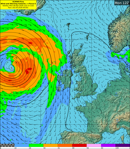
Fíor 9 Samhail ECMWF ag taispeáint na luasanna gaoithe tuartha Dé Luain
Fíor 10 Samhail ECMWF ag taispeáint frasaíocht tuartha Dé Luain
Teachtaireachtaí Sábháilteachta Poiblí
——————— ———————–
Eolas Fúinn