Updated Friday 30th January 2026, valid until further notice
After a week of persistent rain, many rivers are at or above bank-full conditions and rainfall has caused both river levels and surface water levels to rise significantly.
Soils are saturated or waterlogged in many places across the country, increasing the risk of further river and surface water flooding. Any additional rainfall today and over the weekend is expected to result in river and surface water flooding, particularly in the midlands, southeastern, northeastern, and eastern counties. Rivers are expected to overflow their banks, and smaller tributaries may flood more rapidly.
A yellow rainfall warning is in place for southeastern, northeastern, eastern counties from midday on Friday 30th until midnight, so staying up to date with the weather and with your local authority is strongly advised.
Check Warnings & Advisories on met.ie for all the warning details.
From tomorrow (Saturday), the weather will become drier through to Sunday and for the first half of Monday. There will still be rain or showers around, but generally lighter and patchier in nature. The best of the bright or sunny spells will be on Sunday. Winds will be slack for the most part too, though a little breezier on Monday with the chance of further rain moving up from the south later in the day.
…………………………………………………………………………………………………………………..
Issued Thursday 29th January 2026
Overview
Given recent rainfall, river levels and antecedent conditions, further flooding is possible in places over the coming days. Currently, rainfall warnings have been issued for today (Thursday) and tomorrow (Friday). While there are some uncertainties in the weather forecast, especially for Friday, rainfall amounts that could be below warning thresholds may be enough to result in large impacts.
Ground Situation
The month of January has been characterised by frequent rainfall and localised extremes. The image below depicts the above normal rainfall amounts countrywide over the past seven days with the largest deviations from the average in the south and east.
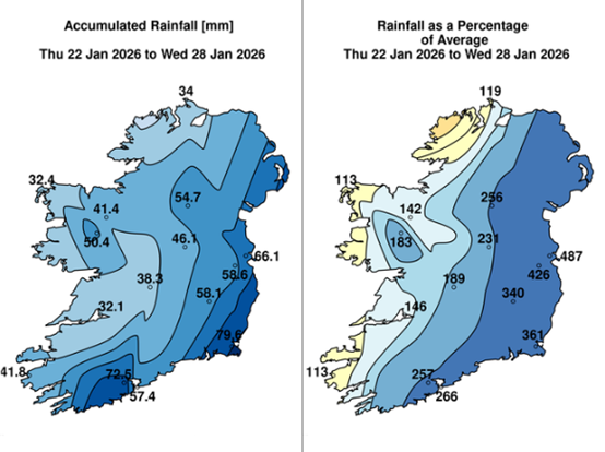
Figure 1: Rainfall: Past seven days
Following recent rainfall, many rivers are at or above bank-full levels. This rainfall, combined with saturated soils, has caused significant rises in river levels and surface water accumulation, particularly across southeastern and eastern areas.
Uncertainty for Friday
A secondary developing depression is forecast to track near to the country on Friday but there has been a huge amount of uncertainty with the track of this system and by extension, the associated rainfall that can be expected with it.
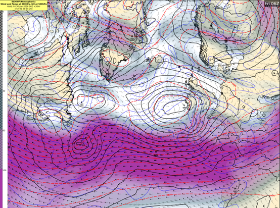
Figure 2 ECMWF Jet Stream and MSLP
The global ECMWF deterministic forecast is predicting the system to get caught up in the left exit of the Jet Stream allowing it to deepen rapidly. However, it is predicting it to be on the very boundary of the Jet so a slight deviation in the positioning would result in a very different outcome.
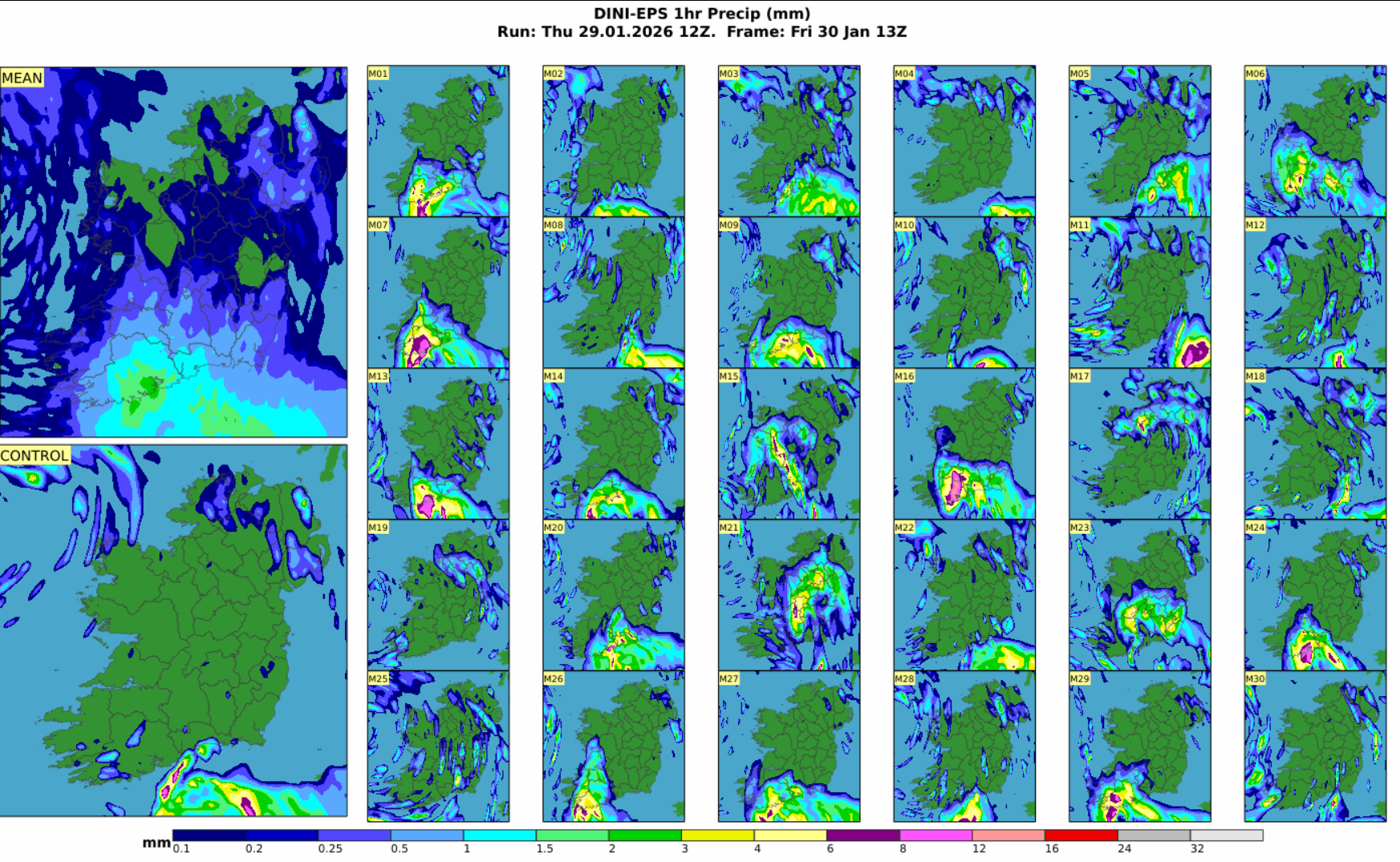
Figure 3 DINI-EPS Individual members showing 1 hour rainfall
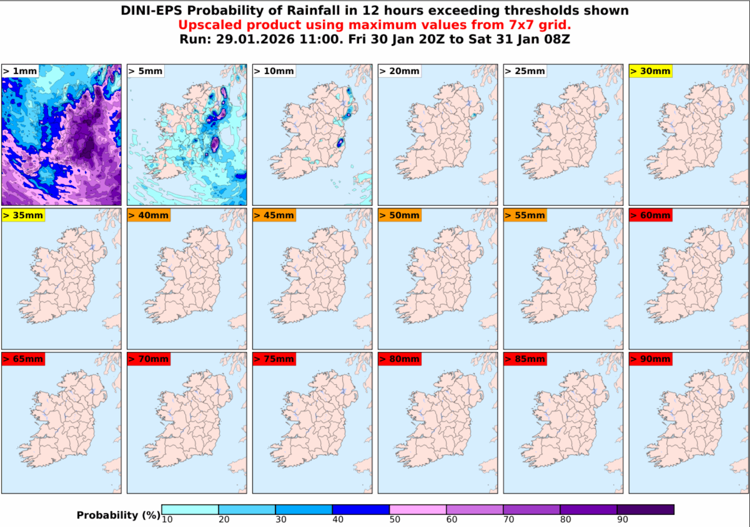
Figure 4 DINI-EPS 12 hour accumulations for Friday
Met Éireann’s own ensemble forecasting system (DINI-EPS) shows a range of possible outcomes of the rainfall associated with this system. While areas may not reach warning thresholds, flooding remains a likelihood. A status yellow rainfall warning has been issued due to the potential for further heavy rain and showers in areas that have already seen significant flooding due to Storm Chandra.
Predicted Rainfall over coming days and Flooding Possibilities
At the moment, rainfall warnings are in effect for today (Thursday) and tomorrow (Friday) for southeastern, northeastern and eastern areas. Many rivers in the southeast, east, and northeast are at or above bank-full levels, and river levels are generally high in other areas. Soils are saturated and waterlogged in many areas, with little improvement in soil conditions forecast in the coming days. Any additional rainfall, particularly in southeastern, northeastern, and eastern areas, could cause further river flooding. Fast-responding and upland catchments are most at risk.
Given the uncertainties for Friday, there is a range of possible rainfall accumulations but ensemble forecasts are a way to give overall guidance by looking at the mean or average amounts of predicted rainfall. It is important to note that due to the figures above being an average of ensemble members, there is the potential for higher or lower rainfall amounts.
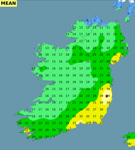
Figure 5 ECMWF Ensemble Mean Rainfall from Thursday to Monday inclusive
There is a strong signal though for southeastern and eastern areas, which have seen the largest accumulations in recent days, to experience the majority of the rainfall out to Monday inclusive.
While the forecast is for some drier spells to develop during the weekend, there are rivers and catchments that are slower to respond to rainfall so there can be delayed impacts.
Public Safety Advice
- Monitor Met Éireann forecasts – conditions may change quickly. Visit https://www.met.ie/ for the most up to date information. Information is also available across the Met Éireann App, social media platforms (@meteireann) and bulletins.
- Check local authority websites and social media channels for information on road closures, flooding updates, and community alerts.
- Allow for disruption when travelling. Plan extra travel time and reduce speed.
- Expect surface water, debris and poor visibility.
- Do not bypass Road Closed signs – the road ahead is unsafe, the damage may be hidden beneath water, and you may be putting your life at risk.
- Do not drive through floodwater – turn back and use another route.
- Check with Transport Operators when planning journeys
- Stay back from riverbanks, streams and canals – water levels may rise quickly.
- Keep children and pets away from waterways and flooded areas.
- Keep away from coastal edges, harbours, piers and low-lying promenades during high tide.
- The Irish Coast Guard advice remains: “Stay Back, Stay High, Stay Dry.”
- Check in with neighbours, older people or anyone who may need assistance in case conditions worsen.
- Up to date information on the response to Storm Chandra is available at gov.ie/stormresponse
The Aftermath of Storm Chandra: Ground conditions, uncertainties, predicted rainfall and flooding possibilities
Updated Friday 30th January 2026, valid until further notice
After a week of persistent rain, many rivers are at or above bank-full conditions and rainfall has caused both river levels and surface water levels to rise significantly.
Soils are saturated or waterlogged in many places across the country, increasing the risk of further river and surface water flooding. Any additional rainfall today and over the weekend is expected to result in river and surface water flooding, particularly in the midlands, southeastern, northeastern, and eastern counties. Rivers are expected to overflow their banks, and smaller tributaries may flood more rapidly.
A yellow rainfall warning is in place for southeastern, northeastern, eastern counties from midday on Friday 30th until midnight, so staying up to date with the weather and with your local authority is strongly advised.
Check Warnings & Advisories on met.ie for all the warning details.
From tomorrow (Saturday), the weather will become drier through to Sunday and for the first half of Monday. There will still be rain or showers around, but generally lighter and patchier in nature. The best of the bright or sunny spells will be on Sunday. Winds will be slack for the most part too, though a little breezier on Monday with the chance of further rain moving up from the south later in the day.
…………………………………………………………………………………………………………………..
Issued Thursday 29th January 2026
Overview
Given recent rainfall, river levels and antecedent conditions, further flooding is possible in places over the coming days. Currently, rainfall warnings have been issued for today (Thursday) and tomorrow (Friday). While there are some uncertainties in the weather forecast, especially for Friday, rainfall amounts that could be below warning thresholds may be enough to result in large impacts.
Ground Situation
The month of January has been characterised by frequent rainfall and localised extremes. The image below depicts the above normal rainfall amounts countrywide over the past seven days with the largest deviations from the average in the south and east.
Figure 1: Rainfall: Past seven days
Following recent rainfall, many rivers are at or above bank-full levels. This rainfall, combined with saturated soils, has caused significant rises in river levels and surface water accumulation, particularly across southeastern and eastern areas.
Uncertainty for Friday
A secondary developing depression is forecast to track near to the country on Friday but there has been a huge amount of uncertainty with the track of this system and by extension, the associated rainfall that can be expected with it.
Figure 2 ECMWF Jet Stream and MSLP
The global ECMWF deterministic forecast is predicting the system to get caught up in the left exit of the Jet Stream allowing it to deepen rapidly. However, it is predicting it to be on the very boundary of the Jet so a slight deviation in the positioning would result in a very different outcome.
Figure 3 DINI-EPS Individual members showing 1 hour rainfall
Figure 4 DINI-EPS 12 hour accumulations for Friday
Met Éireann’s own ensemble forecasting system (DINI-EPS) shows a range of possible outcomes of the rainfall associated with this system. While areas may not reach warning thresholds, flooding remains a likelihood. A status yellow rainfall warning has been issued due to the potential for further heavy rain and showers in areas that have already seen significant flooding due to Storm Chandra.
Predicted Rainfall over coming days and Flooding Possibilities
At the moment, rainfall warnings are in effect for today (Thursday) and tomorrow (Friday) for southeastern, northeastern and eastern areas. Many rivers in the southeast, east, and northeast are at or above bank-full levels, and river levels are generally high in other areas. Soils are saturated and waterlogged in many areas, with little improvement in soil conditions forecast in the coming days. Any additional rainfall, particularly in southeastern, northeastern, and eastern areas, could cause further river flooding. Fast-responding and upland catchments are most at risk.
Given the uncertainties for Friday, there is a range of possible rainfall accumulations but ensemble forecasts are a way to give overall guidance by looking at the mean or average amounts of predicted rainfall. It is important to note that due to the figures above being an average of ensemble members, there is the potential for higher or lower rainfall amounts.
Figure 5 ECMWF Ensemble Mean Rainfall from Thursday to Monday inclusive
There is a strong signal though for southeastern and eastern areas, which have seen the largest accumulations in recent days, to experience the majority of the rainfall out to Monday inclusive.
While the forecast is for some drier spells to develop during the weekend, there are rivers and catchments that are slower to respond to rainfall so there can be delayed impacts.
Public Safety Advice
Eolas Fúinn