Important Information
- Storm Floris has been named by the UK Met Office
- Met Éireann has issued a weather advisory with warnings expected to follow Saturday
- Wet and unseasonably windy weather expected
- A greater number of people will be exposed to these weather conditions due to large number of outdoor events, camping, etc
Some Potential Impacts
- Dangerous travelling conditions
- Fallen trees, debris and loose objects
- Structural damage
- Knock on impacts for outdoor events
- Power outages
- Wave overtopping
- Localised flooding due to leaves and debris
Meteorological Situation
Unseasonably impactful weather is expected for Sunday night and into Monday as a deepening low pressure system, Storm Floris, will likely track to the northwest of Ireland bringing a spell of heavy rain and very strong winds.
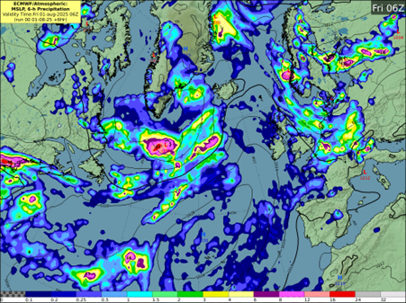
The storm, which has currently not yet formed, is expected to develop through Friday from a frontal wave, currently lying to the south of Nova Scotia.
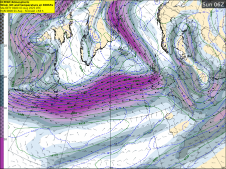
An unusually strong Jet for the time of year will carry the system towards Ireland through the weekend, with the storm deepening rapidly (approximately 20hPa in 24 hours between Sunday and Monday).
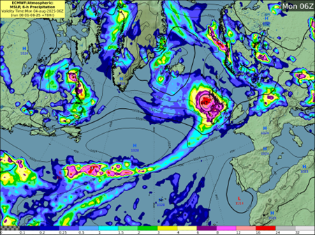
Storm Floris is currently expected to track to the northwest of Ireland through Sunday night and Monday morning, before tracking over Scotland before clearing into the North Sea later in the day.
Forecaster Andrew Doran-Sherlock says:
“Storm Floris will bring a spell of wet and unseasonably windy weather, particularly for northwestern areas, through Sunday night and into Monday. However, there is still some uncertainty in the details so the full impacts of the system cannot yet be determined. By Saturday though, the event will be within the range of our high-resolution DINI forecasting model and warnings will be issued.”
However, as this is a Public Holiday Weekend with a large number of outdoor events and with many people going camping, etc, and with an increased usage of temporary structures such as tents, more people will be at a greater risk of exposure than would normally be the case. And while we are in a period of neap tides, with lowest tidal ranges of this cycle expected on Sunday and Monday, strong onshore winds and high waves may cause wave overtopping in low-lying coastal areas in the northwest and west.
Our advice would be to pay attention to the weather forecasts and warnings issued over the weekend and take them into consideration with any plans you have. And as always, please heed the advice of local authorities.”
Storm Floris: Sunday night and Public Holiday Monday
Important Information
Some Potential Impacts
Meteorological Situation
Unseasonably impactful weather is expected for Sunday night and into Monday as a deepening low pressure system, Storm Floris, will likely track to the northwest of Ireland bringing a spell of heavy rain and very strong winds.
The storm, which has currently not yet formed, is expected to develop through Friday from a frontal wave, currently lying to the south of Nova Scotia.
An unusually strong Jet for the time of year will carry the system towards Ireland through the weekend, with the storm deepening rapidly (approximately 20hPa in 24 hours between Sunday and Monday).
Storm Floris is currently expected to track to the northwest of Ireland through Sunday night and Monday morning, before tracking over Scotland before clearing into the North Sea later in the day.
Forecaster Andrew Doran-Sherlock says:
“Storm Floris will bring a spell of wet and unseasonably windy weather, particularly for northwestern areas, through Sunday night and into Monday. However, there is still some uncertainty in the details so the full impacts of the system cannot yet be determined. By Saturday though, the event will be within the range of our high-resolution DINI forecasting model and warnings will be issued.”
However, as this is a Public Holiday Weekend with a large number of outdoor events and with many people going camping, etc, and with an increased usage of temporary structures such as tents, more people will be at a greater risk of exposure than would normally be the case. And while we are in a period of neap tides, with lowest tidal ranges of this cycle expected on Sunday and Monday, strong onshore winds and high waves may cause wave overtopping in low-lying coastal areas in the northwest and west.
Our advice would be to pay attention to the weather forecasts and warnings issued over the weekend and take them into consideration with any plans you have. And as always, please heed the advice of local authorities.”
Eolas Fúinn