2026 gets underway with cold and wintry conditions
Met Éireann is forecasting a cold and wintry start to the new year as a northerly air-flow becomes established over Ireland, drawing down polar air across the country. Temperatures are expected to fall below average, with the main impacts being frosty and icy nights. There will also be some sleet and snow showers at times, mainly affecting Ulster and north Connacht, while many other areas will experience crisp, bright conditions with plenty of winter sunshine.
People are advised to be prepared for the colder weather and potential hazards, particularly overnight and during the early mornings. The public is encouraged to plan ahead, allow extra time for journeys and take care on icy roads. Met Éireann will continue to monitor conditions and provide updates as the cold spell develops.
Meteorologist Matthew Martin says:
“It is now increasingly likely that a very cold, Arctic air mass will move across Ireland over the coming days. This is being driven by a blocking high-pressure system building in the Atlantic, which will allow the air-flow to turn northerly and draw very cold air southwards from the Arctic.”
“We are expecting very cold and frosty nights, particularly over the weekend, with a chance of some wintry showers. At present, these showers are most likely to affect northern counties, while many southern areas can expect plenty of crisp winter sunshine. We will continue to assess the situation closely in the coming days and will issue any warnings as required, so people are advised to keep a close eye on the forecast.”
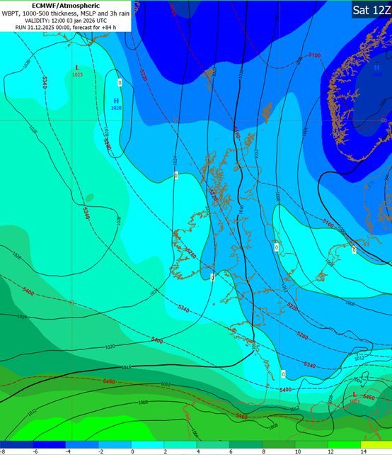
(Fig1: A very cold northerly air-flow is forecast to become established over Ireland this weekend bringing frost, ice and some wintry showers)
HOW TO STAY SAFE DURING WINTRY WEATHER – BE WINTER READY
- Stay up-to date with the forecast and the warnings on ie, the Met Éireann app or Met Éireann socials (@meteireann).
- Wintry showers and icy surfaces will lead to difficult travel conditions.
- Driving conditions will be hazardous, even where roads are gritted, slow down, drive with caution, be aware of other road users and allow extra time for your journey.
- Public transport may also be affected by this spell of wintry weather; people are advised to check with service operators for the latest updates in their area.
- Take extra care while walking: footpaths etc. can be extremely hazardous/slippery due to ice.
- Check on elderly, vulnerable and isolated neighbours.
- Keep your phone charged and take it with you on all journeys. In an emergency dial 999 or 112.
- The Be Winter Ready website https://www.gov.ie/en/campaigns/aa78b9-be-winter-ready provides further advice on preparing for severe weather.
- People are advised to prepare for this period of severe weather including ensuring their mobile phone is fully charged to enable communication.
- Monitor Met Éireann forecasts and/or visit https://www.met.ie/ for the most up to date information. Information is available across social media platforms and other news media sources.
- ESB Emergency Services can be contacted at 1800 372 999. The public can monitor PowerCheck.ie.
- Uisce Éireann Customers can check their website and social media channels for updates and to get in touch with any issues or concerns via our 24/7 customer care centre at 1800 278 278. People can also sign up online to free text alert system to get regular updates about their local supplies – see water.ie.
- People are advised to conserve water, and visit https://www.water.ie for advice.
- The Dublin Region Homeless Executive (DRHE) have a free app which enables members of the public to alert them to the location of anyone sleeping rough, so that outreach teams can make contact with them. If you wish to make a report of a rough sleeper in the Dublin Region please download the app, the link can be found on the following website: https://www.homelessdublin.ie/our-work/news/drhe-launches-new-app-for-public-to-alert-teams-to-location-of-rough-sleepers
- Farmers are advised to take all precautions when dealing with livestock and possibly working alone.
- People travelling long journeys check weather/ road conditions not just where they are starting from, but at their destination and along the route, as conditions may vary significantly.
NOTE THAT:
Warnings can be updated. Please keep in touch with Met Éireann’s social media channels, www.met.ie and the Met Éireann app to stay up to date with the forecast and any warnings’ updates.
The timing and location of extreme weather occurrences can significantly affect their impact. It’s important to note that in any individual weather event, not every location within a warning area may experience the same degree of weather or impacts.
When severe weather is expected, weather and impacts at lower levels are also likely to be experienced. The type and level of impacts can be strongly affected by previous weather conditions. When issuing a warning, Met Éireann takes into consideration the forecasted conditions and thresholds, as well as previous weather conditions that may increase the level of impact expected for particular areas.
2026 gets Underway with Cold and Wintry Conditions
2026 gets underway with cold and wintry conditions
Met Éireann is forecasting a cold and wintry start to the new year as a northerly air-flow becomes established over Ireland, drawing down polar air across the country. Temperatures are expected to fall below average, with the main impacts being frosty and icy nights. There will also be some sleet and snow showers at times, mainly affecting Ulster and north Connacht, while many other areas will experience crisp, bright conditions with plenty of winter sunshine.
People are advised to be prepared for the colder weather and potential hazards, particularly overnight and during the early mornings. The public is encouraged to plan ahead, allow extra time for journeys and take care on icy roads. Met Éireann will continue to monitor conditions and provide updates as the cold spell develops.
Meteorologist Matthew Martin says:
“It is now increasingly likely that a very cold, Arctic air mass will move across Ireland over the coming days. This is being driven by a blocking high-pressure system building in the Atlantic, which will allow the air-flow to turn northerly and draw very cold air southwards from the Arctic.”
“We are expecting very cold and frosty nights, particularly over the weekend, with a chance of some wintry showers. At present, these showers are most likely to affect northern counties, while many southern areas can expect plenty of crisp winter sunshine. We will continue to assess the situation closely in the coming days and will issue any warnings as required, so people are advised to keep a close eye on the forecast.”
(Fig1: A very cold northerly air-flow is forecast to become established over Ireland this weekend bringing frost, ice and some wintry showers)
HOW TO STAY SAFE DURING WINTRY WEATHER – BE WINTER READY
NOTE THAT:
Warnings can be updated. Please keep in touch with Met Éireann’s social media channels, www.met.ie and the Met Éireann app to stay up to date with the forecast and any warnings’ updates.
The timing and location of extreme weather occurrences can significantly affect their impact. It’s important to note that in any individual weather event, not every location within a warning area may experience the same degree of weather or impacts.
When severe weather is expected, weather and impacts at lower levels are also likely to be experienced. The type and level of impacts can be strongly affected by previous weather conditions. When issuing a warning, Met Éireann takes into consideration the forecasted conditions and thresholds, as well as previous weather conditions that may increase the level of impact expected for particular areas.
Eolas Fúinn