Warm and wet. Heat dome brought heatwaves and exceptionally high temperatures
A heat dome developed over western Europe resulted in an unusually hot and humid period for Ireland towards the end of last month, and a remarkable number of record-breaking temperatures across the country. In total, nine out of Met Éireann’s 25 principal weather stations witnessed their all-time highest minimum temperature between June 25th and 26th, while six stations recorded their all-time highest maximum temperature. The exceptional conditions also saw only the third and fourth occurrence of a tropical night* (overnight minimum temperature higher than 20 °C) at a principal weather station in Ireland recorded at Oak Park, Co Carlow and Casement Aerodrome, Co Dublin on the night of June 25th.
Key monthly figures:
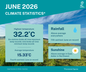
- June 2026 was exceptionally warm, with an average temperature of 15.33 °C, which is 1.65 °C above the 1991-2020 long term average (LTA) and 2.11 °C above the 1961-1990 LTA.
- Provisional figures ranks June 2026 the 4th warmest June in 127 years (since 1900).
- Six of the ten warmest Junes have now occurred since 2001.
- Phoenix Park (one of the long standing stations from the Island of Ireland dataset*) observed its warmest June on record (1900-2026).
- Thirteen stations broke (plus one equalled) their June maximum temperature records, and six of those also broke their all-time maximum temperature records.
- Seventeen stations broke their June highest minimum temperature records (09-09*) and nine of those also broke (plus two equalled) their all-time highest minimum temperature records (09-09).
- Two stations ( Oak Park and Casement) had a tropical nights (09-09 ending Friday 26th).
- Three stations (Oak Park, Moore Park, Co Cork and Gurteen, Co Tipperary) had heatwaves* between Monday 22nd and Friday 26th.
June Climate Statement highlights.
June 2026 was warm and relatively wet overall. A heat dome from the south brought exceptionally high daytime and nighttime temperatures, along with high humidity, towards the end of the month.
The first third of the month was dominated by Atlantic low pressure which brought widespread frontal rain interspersed with showers, sometimes thundery, on most days. Polar maritime air masses kept it relatively cool during this period, especially in the West.
The second third of the month saw a battleground between high pressure to the south and low pressure to the west while it gradually warmed up. Initially high pressure built north bringing several dry days before low pressure to the west brought active weather fronts across the country towards the end of the period.
High pressure built over the country again at the beginning of the final third of the month, which led to a drier and sunnier period with temperatures increasing day on day. A heat dome, that had developed over western Europe, pushed north over the country and culminated in an exceptionally hot and humid period between Monday 22nd and Friday 26th. Intense thunderstorms broke out in places on Thursday 25th and Friday 26th before a cooler Atlantic airmass pushed over the country from the west on Saturday 27th. The final few days of the month saw a return to average temperatures and scattered rain or showers interspersed with dry periods.
Rainfall: Above average everywhere, driest in the South
- Belmullet, Co Mayo had its wettest June since 2002 with 127.5 mm 174% of its LTA).
- Five stations (Phoenix Park, Shannon Airport, Dublin Airport, Markree, and Gurteen) had their wettest June since 2012.
- Cork Airport had its wettest just since 2013 while Mullingar had its wettest June since 2016.
All rainfall totals were above their 1991-2020 Long-Term Average (LTA) for the month. Percentage of monthly rainfall values ranged from 102% (the month’s lowest monthly rainfall total of 70.5 mm) at Roches Point, Co Cork to 175% (127.5 mm) at Belmullet, Co Mayo (its wettest June since 2002). Monthly rainfall totals were as much as 143.6 mm (154% of its LTA) at Newport, Co Mayo. The highest daily rainfall total was 26.8 mm at Cork Airport on Friday 5th.
The number of rain days* ranged from 16 days at Oak Park, Co Carlow to 23 days at five stations. The number of wet days* ranged from 11 days at both Oak Park, Co Carlow and Dublin Airport, Co Dublin to 21 days at Malin Head, Co Donegal. The number of very wet days* ranged from 2 days at Oak Park, Co Carlow to 6 days at both Shannon Airport, Co Clare and Dublin Airport. Five stations (Phoenix Park, Co Dublin, Shannon Airport, Co Clare, Dublin Airport, Markree, Co Sligo and Gurteen, Co Tipperary) had their wettest June since 2012, Cork Airport, Co Cork had its wettest June since 2013 while Mullingar, Co Westmeath had its wettest June since 2016.
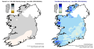
Rainfall % of 1991 – 2020 Monthly Average for June 2026 (Provisional). Total Monthly Rainfall (mm) for June 2026 (Provisional).
Temperature: Above average everywhere, record high June maximum and minimum air temperatures at numerous stations
All mean air temperatures across the country were above their LTA for the month. Deviations from mean air temperature ranged from +0.5 °C (14.7 °C) at Newport, Co Mayo to +2.3 °C at both Dublin Airport, Co Dublin (15.6 °C mean temperature) (its 2nd warmest June on record (length 84 years)) and Phoenix Park, Co Dublin (16.2 °C mean temperature) (its warmest June on record (length 127 years)). Mean temperatures for the month ranged from 13.7 °C (1.0 °C above its LTA) at Malin Head, Co Donegal to 16.2 °C (2.3 °C above its LTA) at Phoenix Park.
The month’s highest temperature was reported at Athenry, Co Galway on Thursday 25th with a temperature of 32.2 °C (its highest all-month daily maximum air temperature on record (length 16 years)). The month’s lowest air temperature and grass minimum temperature were both recorded on Monday 8th at Markree, Co Sligo. The lowest air minimum was 4.0 °C while the lowest grass minimum was -1.0 °C. There was no air frost reported this month. Less than half of stations reported ground frost. The number of days with ground frost ranged from zero days at most stations to 1 day at a few stations.
Thirteen stations broke (plus one equalled) their June maximum temperature records, and six of those also broke their all-time maximum temperature records (see table 1). Seventeen stations broke their June highest minimum temperature records (09-09) and nine of those also broke (plus two equalled) their all-time highest minimum temperature records (09-09). Stations that broke their all-time highest minimum temperature records were Casement, Co Dublin (20.3 °C (the second highest minimum temperature ever recorded at a synoptic station behind 20.5 °C at Valentia in July 2021)), Oak Park, Co Carlow (20.3 °C), Phoenix Park, Co Dublin (19.8 °C), Mullingar, Co Westmeath (19.6 °C), Moore Park, Co Cork (19.6 °C) , Dunsany, Co Meath (19.3 °C), Sherkin Island, Co Cork (18.5 °C), Gurteen, Co Tipperary (18.3 °C), Mount Dillon, Co Roscommon (17.8 °C), Dublin Airport (19.1 °C (equalled with 6th September 2016)) Johnstown Castle, Co Wexford (19.0 °C (equalled with 2nd August 1995)).
Two stations, Oak Park and Casement, had a tropical night (09-09 ending Friday 26th). Three stations Oak Park, Moore Park and Gurteen met heatwave* criteria between Monday 22nd and Friday 26th.
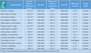
Table 1: Principal stations new provisional June maximum temperature records compared to previous station June records. 6 principal stations also broke their previous all-time highest maximum temperature records.
Sunshine: Above average in the East, duller in Northwest
Available sunshine totals were mostly above their LTA for the month. Percentage of monthly sunshine values ranged from 103% (169.8 hours) at Shannon Airport, Co Clare to 122% (the month’s highest monthly sunshine total of 204.9 hours) at Casement Aerodrome, Co Dublin. Monthly sunshine totals were lowest at Belmullet, Co Mayo with 122.1 hours (No LTA comparison*). The highest number of daily sunshine hours recorded this month was 15.5 hours at Malin Head, Co Donegal on Saturday 20th. The number of dull days* ranged from 1 day at Casement Aerodrome, Co Dublin to 6 days at both Johnstown Castle, Co Wexford and Valentia Observatory, Co Kerry.
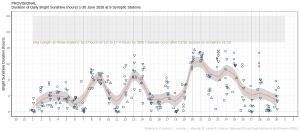
Hours of Bright Sunshine observed at nine stations for each day of the month of June 2026, grouped by province relative to the highest number of hours possible by end of month (shaded box).
Wind: Gales reported at one station
Monthly mean wind speeds ranged from 5.8 knots (10.7 km/h) at Ballyhaise, Co Cavan to 14.6 knots (27.0 km/h) at Mace Head, Co Galway. Gales were reported on Saturday 6th at Roches Point, Co Cork. The number of days with gale force winds ranged from zero days at most stations to 1 day at Roches Point, Co Cork. There were no strong gales or storms reported this month. The month’s highest gust was reported at both Sherkin Island, Co Cork on Friday 5th and at Roches Point, Co Cork Saturday 6th with 44 knots (82 km/h). The highest 10-minute wind speed was 37 knots (69 km/h) reported at Roches Point, Co Cork on Saturday 6th.
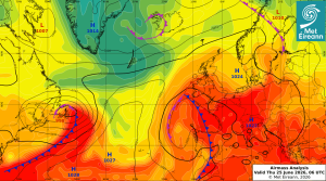
Airmass Analysis chart 06 UTC 25 June 2026: Exceptionally hot and humid airmass had moved over Ireland from the south.
Full PDF report and charts are available here
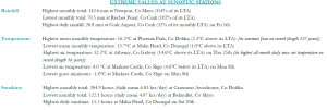
Extreme values for June 2026 at synoptic stations.
Notes to Editor:
- *Issued by Met Éireann on Thursday 2nd July 2026. This report is based on available preliminary data from 25 principal weather stations operated by Met Éireann. Synoptic station data is midnight to midnight UTC.
- Overnight highest minimum temperatures and tropical nights are measured 9am to 9am (09-09) according to WMO standards. A tropical night is the count of days when the daily minimum temperature, is greater than 20 °C (09-09).
- Long-Term Averages (LTAs) and “average” refer to the period 1991-2020 unless stated.
- A rain day is a day on which 0.2 mm or more of rainfall is measured. A wet day is a day with 1.0 mm or more of rainfall. A dull day is a day with less than 0.5 hours of sunshine. A very wet day is a day with 10.0 mm or more of rainfall.
- Climatological dry periods – An absolute drought is a period of 15 or more consecutive days to none of which is credited 0.2 mm or more of precipitation. A partial drought is a period of at least 29 consecutive days, the mean daily rainfall of which does not exceed 0.2 mm. A dry spell is a period of 15 or more consecutive days to none of which is credited 1.0 mm or more of precipitation (i.e. daily tot < 1.0 mm).
- A heatwave occurs where there are 5 consecutive days or more with maximum temperature over 25°C (that is, a daily maximum screen air temperature > 25° C).
- The ‘Island of Ireland’ dataset is 125 years long and runs between 1900 and 2023. For this dataset the long term averages from the 1961-1990 reference period are used for comparison as is standard for long-term climate change assessments.
- Sunshine data is from the Autosol Network. LTAs for these sites are currently not used for comparison purposes.
- For more information or interview opportunities with a Met Éireann spokesperson, please contact us at enq@met.ie.