Very warm and dry
August 2026 was notably warm and drier than average for most of the month, with all mean air temperatures across the country landing above their long-term average for 1991-2020. The national mean August temperature of 16.27 °C, made it the ninth warmest on record since 1900, while the highest August maximum temperature on record for all Dublin stations was recorded at Casement Aerodrome on Wednesday 12th. Although high pressure dominated proceedings for much of the period, it did give way to lower pressure towards the back end of the month and this brought the first appreciable rainfall for over two months to parts of the Southeast, with widespread rain or showers sometimes heavy and thundery.
Key National Figures:
- The national mean August temperature was 16.27 °C, ranking as the 9th warmest August on record since 1900.
- 16.27 °C is 1.60 °C above the 1961-1990 LTA and 1.01 °C above the most recent climatological standard period 1991-2020.
- Three of the ten warmest Augusts have occurred since 2001, while none of the ten coolest have occurred in that period.
- The warmest August was in 1995 (31 years ago) and the coolest was in 1912 (114 years ago).
- Provisional gridded rainfall for Ireland shows August 2026 was the 28th driest on record with 86 mm or 84% of the 1991-2020 LTA.
- Augusts in the past have ranged from 11.8 to 216.5 mm, the highest was in 1985 (41 years ago) and the lowest was in 1976 (50 years ago).
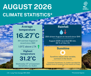
August Climate Statement highlights.
August 2026 was warmer and drier than average for most of the month with higher-than-average pressure overall. The pattern changed towards the end of the month when low pressure took control. The month began with high pressure pulling away to allow low pressure to move up over the country from the southwest for a few days during the middle of the first week. This brought outbreaks of rain or showers, heavy in places. High pressure re-establishing over the country towards the end of the first week.
High pressure dominated the second week keeping it mostly dry away from the North and West where scattered outbreaks of rain or showers continued at times. During the middle of the second week high pressure moved to the east allowing a hot tropical continental airmass to be drawn north over the country. This brought the hottest period of the month and exceptionally high day and nighttime temperatures, especially for the East.
The third week became cooler, cloudier and somewhat wetter as Atlantic low pressure to the northwest moved closer bringing rain or showers at times, especially to the North and West. The fourth week began dry and cool with high pressure moving over the country from the west. A marked change in pattern began on Tuesday 25th as low pressure to the south pushed milder air north along with widespread rain or showers. This brought the first appreciable rainfall for over two months to parts of the Southeast. Low pressure stayed in control for the rest of the month with widespread rain or showers sometimes heavy and thundery.
Rainfall: Dry overall with the longest partial drought on record at Oak Park, Co Carlow
- A partial drought* at Oak Park, Co Carlow that began on Saturday 20th June continued until Monday 24th August, lasting 66 days. This is the longest partial drought on record since 1941.
The majority of monthly rainfall totals across the country were below their 1991-2020 Long-Term Average (LTA). Intense convective rainfall brought some localised high daily totals at times. Percentage of monthly rainfall values ranged from 62% (64.7 mm) at Athenry, Co Galway to 135% (95.7 mm) at Phoenix Park, Co Dublin. Monthly rainfall totals ranged from 56.3 mm at both Dunsany, Co Meath (72% of its LTA) and Casement Aerodrome, Co Dublin (79% of its LTA) to 111.5 mm (84% of its LTA) at Newport, Co Mayo. The highest daily rainfall total was 61.8 mm at Phoenix Park, Co Dublin on Thursday 27th.
The number of rain days* ranged from 11 days at Roches Point, Co Cork to 23 days at both Belmullet and Knock Airport, Co Mayo. The number of wet days* ranged from 8 days at Moore Park, Co Cork to 19 days at both Newport and Belmullet, Co Mayo. The number of very wet days* ranged from zero days at a few stations to 5 days at Johnstown Castle, Co Wexford. Numerous dry spells* and partial droughts* that were on-going through July finished in early August. A second summer dry spell* occurred at Oak Park, Co Carlow between Tuesday 4th and Tuesday 18th August, lasting 15 days. A partial drought* at Oak Park, Co Carlow that began on Saturday 20th June continued until Monday 24th August, lasting 66 days. This is the longest partial drought on record since 1941. The previous longest partial drought on record was 62 days at Roches Point, Co Cork in the summer of 1983.
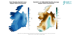
Total Monthly Rainfall (mm) for August 2026 (Provisional). Rainfall % of 1991 – 2020 Monthly Average for August 2026 (Provisional).
Temperature: Above average everywhere, record high August maximum temperature for Dublin
- Four stations in the Midlands and East broke their August maximum temperature record on Wednesday 12th.
- Casement Aerodrome, Co Dublin with a temperature of 31.2 °C recorded the highest August maximum temperature on record for all Dublin stations (length 127 years)).
- Ten stations broke their highest August daily minimum temperature record between Wednesday 12th and Friday 14th.
All mean air temperatures across the country were above their LTA for the month. Deviations from mean air temperature ranged from +0.4 °C (15.9 °C mean temperature) at Newport, Co Mayo to +1.5 °C at both Casement Aerodrome, Co Dublin (16.6 °C mean temperature) and Roches Point, Co Cork (17.1 °C mean temperature). Mean temperatures for the month ranged from 14.9 °C (1.1 °C above its LTA) at Knock Airport, Co Mayo to 17.1 °C (1.5 °C above its LTA) at Roches Point, Co Cork. The month’s highest temperature was reported at Casement Aerodrome, Co Dublin on Wednesday 12th with a temperature of 31.2 °C (its highest maximum temperature for August on record (length 62 years) and the highest August maximum temperature on record for all Dublin stations (length 127 years)). The month’s lowest air and grass minimum temperatures were both recorded on Monday 24th at Mount Dillon, Co Roscommon. The lowest air minimum was 0.4 °C while the lowest grass minimum was -2.4 °C. There was no air frost reported this month.
Less than half of stations reported ground frost. The number of days with ground frost ranged from zero days at most stations to 3 days at Mount Dillon, Co Roscommon. Four stations in the Midlands and East broke their August maximum temperature record on Wednesday 12th. These were Casement Aerodrome (31.2 °C), Phoenix Park, Co Dublin (30.9 °C), Dunsany, Co Meath (30.5 °C) and Gurteen, Co Tipperary (29.3 °C) (record lengths between 18 and 127 years), while Dunsany, Co Meath also broke its all-month maximum temperature record. Ten stations broke their highest August daily minimum temperature record between Wednesday 12th and Friday 14th, while two of those stations also broke their all-month highest minimum temperature record.
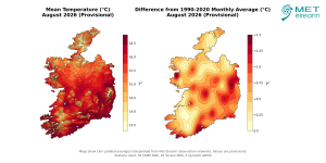
Mean Temperature (°C) for August 2026 (Provisional). Difference from 1991-2020 LTA (°C) for August 2026 (Provisional)
Sunshine: Sunniest in the South
Sunshine values were variable across the country. Percentage of monthly sunshine values ranged from 99% (153.1 hours) at Casement Aerodrome, Co Dublin to 107% (152.7 hours) at Shannon Airport, Co Clare. Monthly sunshine totals ranged from 101.3 hours (No LTA comparison*) at Malin Head, Co Donegal to 200.7 hours (No LTA comparison*) at Johnstown Castle, Co Wexford (its sunniest August since 2003). The highest number of daily sunshine hours recorded this month was 13.8 hours at Casement Aerodrome, Co Dublin on Friday 7th. The number of dull days* ranged from 4 days at a few stations to 9 days at Belmullet, Co Mayo.
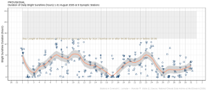
Hours of Bright Sunshine observed at nine stations for each day of the month of August 2026, grouped by province relative to the highest number of hours possible by end of month (shaded box).
Wind: Not significantly strong
Monthly mean wind speeds ranged from 4.1 knots (7.6 km/h) at Ballyhaise, Co Cavan to 11.8 knots (21.9 km/h) at Malin Head, Co Donegal. There were no days with gales, strong gales or storms reported this month. The month’s highest gust and 10-minute mean wind speed were both reported at Malin Head, Co Donegal on Wednesday 5th. The highest gust was 36 knots (67 km/h) while the month’s highest 10-minute mean wind speed was 29 knots (54 km/h).
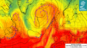
Airmass Analysis chart 12 UTC 12 August 2026: Exceptionally hot and humid airmass had moved over Ireland from the south again bringing record high August temperatures at several stations.
Full PDF report and charts are available here
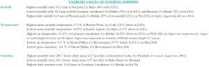
Extreme values for August 2026 at synoptic stations.
Notes to Editor:
- *Issued by Met Éireann on Wednesday 2nd September 2026. This report is based on available preliminary data from 25 principal weather stations operated by Met Éireann. Synoptic station data is midnight to midnight UTC.
- Overnight highest minimum temperatures and tropical nights are measured 9am to 9am (09-09) according to WMO standards. A tropical night is the count of days when the daily minimum temperature, is greater than 20 °C (09-09).
- Long-Term Averages (LTAs) and “average” refer to the period 1991-2020 unless stated.
- A rain day is a day on which 0.2 mm or more of rainfall is measured. A wet day is a day with 1.0 mm or more of rainfall. A dull day is a day with less than 0.5 hours of sunshine. A very wet day is a day with 10.0 mm or more of rainfall.
- Climatological dry periods – An absolute drought is a period of 15 or more consecutive days to none of which is credited 0.2 mm or more of precipitation. A partial drought is a period of at least 29 consecutive days, the mean daily rainfall of which is less than or equal to 0.2 mm. A dry spell is a period of 15 or more consecutive days to none of which is credited 1.0 mm or more of precipitation (i.e. daily tot < 1.0 mm).
- A heatwave occurs where there are 5 consecutive days or more with maximum temperature over 25°C (that is, a daily maximum screen air temperature > 25° C).
- The ‘Island of Ireland’ dataset is 125 years long and runs between 1900 and 2023. For this dataset the long term averages from the 1961-1990 reference period are used for comparison as is standard for long-term climate change assessments.
- Sunshine data is from the Autosol Network. LTAs for these sites are currently not used for comparison purposes.
- For more information or interview opportunities with a Met Éireann spokesperson, please contact us at enq@met.ie.