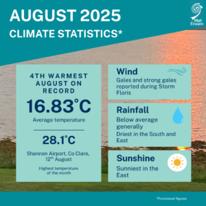
Fourth warmest August on record, Dry for most
August 2025 was the Fourth warmest August and ninth warmest of any month in 126 years of records (using the Island of Ireland dataset*), with an average temperature of 16.83 °C, which is 2.15 °C above the 1961-1990 long-term average (LTA) for August and 1.56 °C above the more recent 1991-2020 LTA. Most stations saw rainfall below average (75% of the LTA for Ireland overall), making this August the 22nd driest since 1941.
August 2025 was very warm with temperatures well above average at all stations. It was wet in parts of the West but dry elsewhere, especially in the East and South as high pressure dominated through most of the month. The heat over central and western Europe continued during August, with some of that heat pushing north over Ireland during the second week of the month where several stations saw maximum temperatures up to 28 °C on Tuesday 12th.
Key Figures:
- August 2025 was the warmest month of 2025 so far and the warmest August since 1995 (which had a mean temperature of 17.75 °C).
- Continuing the recent warmer-than-normal monthly trend, this is the 6th consecutive month with temperatures in the respective top 9 averages on record in 126 years of records.
- Of the top ten warmest August’s, three have occurred since 2001 (2025, 2003 and 2022). The warmest August was in 1995 with an average temperature of 17.75 °C and the coldest August was in 1912 with an average temperature of 11.63 °C.
- August 2025 observed an average of 78.1 mm rainfall, which is 75% of the 1991-2020 LTA, the driest August since 2022 and 22nd driest overall since 1941.
August Climate Statement highlights
During the first week of August 2025, high pressure to the south and low pressure to the north brought a mostly westerly airflow. This setup allowed several weak weather fronts to cross the country from the west bringing scattered outbreaks of mostly light rain or showers. On Monday the 4th, storm Floris, named by the UK Met Office, tracked to the north of Ireland, bringing the strongest winds of the month to the Northwest.
The second week saw high pressure building north over Ireland and shifting to the east, drawing a very warm airmass up from the south. This led to the warmest period of the month with several very warm days. It stayed mostly dry in the East while the West saw some showers at times. The third week saw high pressure building to the north keeping it mostly dry nationwide. However, a northeast airflow brought more cloud and cooler temperatures towards the end of the week. At the start of the fourth week, a warm front moved in from the southwest, introducing a warmer airmass with a lot of cloud and patchy rain or drizzle at times.
On Monday the 25th, the weather pattern shifted dramatically as Ex-Hurricane Erin, named by the National Hurricane Center, moved into the mid-latitudes while transitioning into a mid-latitude storm, and stimulating the North Atlantic jet stream. Erin’s remnants stalled between Ireland and Iceland, steering several weather fronts, showery troughs and other low pressure systems across the country from the west in a strong westerly airflow, with the heaviest rainfall in the West.
Rainfall: Below average nearly everywhere, driest in the South and East
Nearly all rainfall totals were below their 1991-2020 Long-Term Average (LTA) for the month. Percentage of monthly rainfall values ranged from 37% (the lowest monthly rainfall total of 30.5 mm) at Moore Park, Co Cork to 141% (147.0 mm) at Athenry, Co Galway. The highest monthly rainfall total was 148.2 mm (111% of its LTA) observed at Newport, Co Mayo. The highest daily rainfall total was 30.1 mm at Athenry, Co Galway on Thursday 28th.
The number of rain days* ranged from 9 days at Phoenix Park, Co Dublin to 21 days at Newport, Co Mayo. The number of wet days* ranged from 6 days at both Phoenix Park, Co Dublin and Moore Park, Co Cork to 18 days at Newport, Co Mayo. The number of very wet days* ranged from zero days at Roches Point, Co Cork to 6 days at both Newport, Co Mayo and Athenry, Co Galway.
Six stations, mostly in the East and South, had dry spells* between August 5th and 24th lasting between 15 and 20 days. Two of those stations, Phoenix Park (lasting 18 days) and Dublin Airport, Co Dublin (lasting 15 days) also had absolute droughts* between August 5th and 22nd. Dublin Airport also had its driest August since 2005.
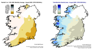
Rainfall % of 1991 – 2020 Monthly Average for August 2025 (Provisional) Total Monthly Rainfall (mm) for August 2025 (Provisional)
Temperature: Significantly above average everywhere, with record mean temperatures in places
- Six stations had their warmest August on record (record lengths between 14 and 29 years). Seven longer standing stations had their warmest August since 1995. Five stations had their warmest August since 1997 and four stations had their warmest August since 2003.
- Nine stations had their highest monthly minimum for August on record (record lengths 10 to 85 years) including long standing stations Valentia Obs., Co Kerry (11.2 °C) and Malin Head, Co Donegal (11.8 °C).
- Two stations had their highest mean maximum temperature for August on record (lengths 14 and 21 years) and six stations had their highest mean minimum for August on record (lengths 14 to 85 years) including Valentia Obs., Co Kerry.
All mean air temperatures across the country were above their LTA for the month. Deviations from mean air temperature ranged from +1.2 °C at several stations including Newport, Co Mayo (16.7 °C), Johnstown Castle, Co Wexford (16.6 °C), Ballyhaise, Co Cavan (16.0 °C) and Claremorris, Co Mayo (15.8 °C) to +1.7 °C at Valentia Observatory, Co Kerry (17.1 °C), Sherkin Island, Co Cork (17.1 °C), Moore park, Co Cork (16.9 °C), Gurteen, Co Tipperary (16.5 °C) and Knock Airport, Co Mayo (15.5 °C). Mean temperatures ranged from 15.5 °C (1.7 °C above its LTA) at Knock Airport, Co Mayo to 17.2 °C (1.3 °C above its LTA) at Shannon Airport, Co Clare. The month’s lowest temperatures were recorded on Sunday 10th with the lowest air minimum reported at Mullingar, Co Westmeath with a temperature of 6.5 °C and the lowest grass minimum reported at Phoenix Park, Co Dublin with 1.6 °C. The highest maximum was reported on Tuesday 12th at Shannon Airport, Co Clare with a temperature of 28.1 °C. There was no air or ground frost reported this month.
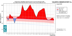
Valentia Observatory, Co Kerry Temperature: Daily mean departure from LTA for August 2025 based on 09-09hr Max/Min values.
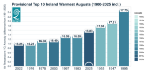
Provisional top 10 warmest August’s on record for Ireland (using the Island of Ireland dataset*)
Sunshine: Highest in the East, lowest in the West
Sunshine values were variable across the country. Percentage of monthly sunshine values ranged from 101% (monthly sunshine total of 145.0 hours) at Shannon Airport, Co Clare to 123 % (the month’s highest monthly sunshine total of 190.1 hours) at Casement Aerodrome, Co Dublin. Monthly sunshine totals were lowest at Knock Airport, Co Mayo with 87.3 hours (no LTA comparison*). The highest number of daily sunshine hours recorded this month was 13.2 hours at Malin Head, Co Donegal on Sunday 17th. The number of dull days2 ranged from 1 day at Johnstown Castle, Co Wexford to 9 days at Valentia Observatory, Co Kerry.
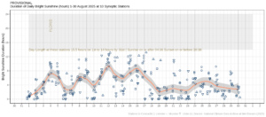
Hours of Bright Sunshine observed at nine stations for each day of the month of August 2025, grouped by province relative to the highest number of hours possible by end of month (shaded box).
Wind: Strong gales reported during storm Floris
Monthly mean wind speeds ranged from 5.4 knots (10.0 km/h) at Mount Dillon, Co Roscommon to 13.8 knots (25.6 km/h) at Mace Head, Co Galway. On Monday 4th, during Storm Floris, gales were reported at five stations, with up to strong gale winds reported at Malin Head, Co Donegal. Gales were also reported on Saturday 30th at Mace Head, Co Galway and Sunday 31st at Mace Head and Belmullet, Co Mayo. The number of days with gales ranged from zero days at most stations to 3 days at Mace Head, Co Galway. Strong gales were reported at one station, Malin Head, Co Donegal on Monday 4th. Both the month’s highest gust and highest 10-minute mean wind speed were reported at Malin Head, Co Donegal on Monday 4th. The highest gust was 56 knots (104 km/h) while the month’s highest 10-minute mean wind speed was 43 knots (80 km/h).
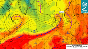
Airmass Analysis chart 12 UTC 4 August 2025: Storm Floris brought strong gales to the North.
Full PDF report and charts are available here
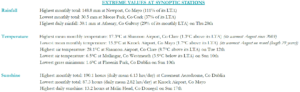
Extreme values for August 2025 at synoptic stations.
Notes to Editor:
- *Issued by Met Éireann on Tuesday 2nd September 2025. This report is based on available preliminary data from 25 principal weather stations operated by Met Éireann. Synoptic station data is midnight to midnight UTC. Long-Term Averages (LTAs) and “average” refer to the period 1991-2020 unless stated.
- A rain day is a day on which 0.2 mm or more of rainfall is measured. A wet day is a day with 1.0 mm or more of rainfall. A dull day is a day with less than 0.5 hours of sunshine. A very wet day is a day with 10.0 mm or more of rainfall.
- Climatological dry periods – An absolute drought is a period of 15 or more consecutive days to none of which is credited 0.2 mm or more of precipitation. A partial drought is a period of at least 29 consecutive days, the mean daily rainfall of which does not exceed 0.2 mm. A dry spell is a period of 15 or more consecutive days to none of which is credited 1.0 mm or more of precipitation (i.e. daily tot < 1.0 mm).
- A heatwave occurs where there are 5 consecutive days or more with maximum temperature over 25°C (that is, a daily maximum screen air temperature > 25° C).
- The ‘Island of Ireland’ dataset is 125 years long and runs between 1900 and 2023. For this dataset the long term averages from the 1961-1990 reference period are used for comparison as is standard for long-term climate change assessments.
- Sunshine data is from the Autosol Network. LTAs for these sites are currently not used for comparison purposes.
- For more information or interview opportunities with a Met Éireann spokesperson, please contact us at enq@met.ie.