Mild and wet overall
April 2024 was another month dominated by Atlantic low pressure with above average rainfall and temperatures. A five-day dry window between 20th and 24th, where high pressure briefly took control, brought a period of much needed drying with plenty of sunshine.
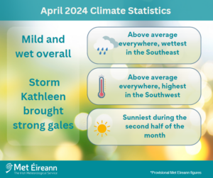
April 2024 Climate Statistics
The first week saw low pressure to the south and southwest in control. Storm Olivia, named by The Portuguese Institute for Sea and Atmosphere (IPMA), tracked northwards to the west of Ireland on Thursday 4th and Friday 5th with its associated frontal system crossing the country from the south. Storm Kathleen, named by Met Éireann, followed a similar track to Olivia and brought the windiest period of the month on Saturday 6th as the deep low pressure centre moved north close to west coast. Another low pressure system moved to the south and east of Ireland and brought widespread heavy rain, concentrated in the Midlands, South and East on Monday 8th. The track of Atlantic low pressure systems shifted to the north of Ireland between Wednesday 10th and Friday 19th as high pressure built over mainland Europe. Further active weather fronts crossed the country during this period, interspersed with showers, with the heaviest rain concentrated in the West and North. High pressure built from the southwest and brought five mostly dry and mild days with more sunshine between Saturday 20th and Wednesday 24th. The final six days of the month saw low pressure, over or to the south of Ireland, take control once again with rain or showers on most days.
Rainfall: Above average everywhere, wettest in the Southeast
All rainfall totals were above their 1981-2010 Long-Term Average (LTA) for the month. Percentage of monthly rainfall values ranged from 105% (monthly rainfall total of 79.5 mm) at Finner, Co Donegal to 189% (April 2024’s highest monthly rainfall total of 132.9 mm) at Johnstown Castle, Co Wexford (its wettest April since 2002 and 4th wettest April since 1941). Monthly rainfall totals for the month were lowest at Phoenix Park, Co Dublin with 63.3 mm (120% of its LTA). The month’s wettest day was also recorded at Johnstown Castle, Co Wexford with 25.8 mm on Monday 8th. The number of rain days* ranged from 17 days at Mace Head, Co Galway to 24 days at both Claremorris, Co Mayo and Knock Airport, Co Mayo. The number of wet days* ranged from 12 days at Phoenix Park, Co Dublin to 20 days at Mullingar, Co Westmeath. The number of very wet days* ranged from 1 day at Phoenix Park, Co Dublin to 4 days at both Mount Dillon, Co Roscommon and Valentia Observatory, Co Kerry. Eight stations had their wettest April since 2009.
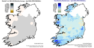
Rainfall % of 1981 – 2010 Monthly Average for April 2024 (Provisional) Total Monthly Rainfall (mm) for April 2024 (Provisional)
Temperature: Above average everywhere, highest in the Southwest
All mean air temperatures across the country were above their LTA for the month. Deviations from mean air temperature for the month ranged from 0.2 °C (8.6 °C mean temperature) at Markree, Co Sligo to 1.2 °C (9.4 °C and 9.6 °C mean temperature) at Phoenix Park, Co Dublin and Oak Park, Co Carlow respectively. Mean temperatures for the month ranged from 8.2 °C (0.9 °C above its LTA) at Knock Airport, Co Mayo to 10.2 °C (0.7 °C above its LTA) at Shannon Airport, Co Clare. The month’s highest temperature was reported at Newport, Co Mayo on Sunday 21st with a temperature of 20.1 °C. Both the month’s lowest air and grass minimum temperature were recorded on Saturday 27th at Mount Dillon, Co Roscommon. The lowest air minimum was -2.2 °C while the lowest grass minimum was -7.4 °C. More than half of stations reported ground frost. The number of days with ground frost ranged from zero days at a few stations to 18 days at Mount Dillon, Co Roscommon. Less than half of stations reported air frost. The number of days with air frost ranged from zero days at Phoenix Park, Co Dublin to 4 days at both Dublin Airport and Casement Aerodrome, Co Dublin. Two stations, Johnstown Castle, Co Wexford (record length 54 years) with 3.5 °C and Roches Point, Co Cork (record length 19 years) with 3.9 °C had their highest minimum temperature for April on record.
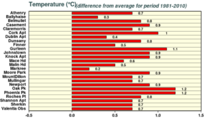
Monthly mean departure from the 1981-2010 Log Term Averages for April 2024 at synoptic stations
Sunshine: Sunniest during the second half of the month
Percentage of LTA sunshine values were variable across the country. Percentage of monthly sunshine values ranged from 100% (monthly sunshine total of 152.7 hours) at Casement Aerodrome, Co Dublin to 106% (the month’s highest monthly sunshine total of 164.6 hours) at Shannon Airport, Co Clare. Monthly sunshine totals were lowest at Valentia Observatory, Co Kerry with 128.5 hours (No LTA comparison*). The highest number of daily sunshine hours recorded this month was 13.7 hours at Belmullet, Co Mayo on both Saturday 20th and Sunday 21st. The number of dull days* ranged from 4 days at a few stations to 7 days at both Valentia Observatory, Co Kerry and Cork Airport, co Cork.
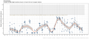
Hours of Bright Sunshine observed at each station for each day of April 2024, grouped by province relative to the highest number of hours possible by end of month (shaded box)
Wind: Storm Kathleen brought strong gales
Monthly mean wind speeds ranged from 6.4 knots (11.9 km/h) at Ballyhaise, Co Cavan to 15.0 knots (27.8 km/h) at Malin Head, Co Donegal. Gales were reported on 7 days during the month with up to strong gales reported on Saturday 6th during storm Kathleen. The number of days with gales ranged from zero days at a few stations to 5 days at Malin Head, Co Donegal. The number of days with strong gales ranged from zero days at most stations to 1 day at five stations. The month’s highest 10-minute mean wind speed of 46 knots (85 km/h) was reported at Sherkin Island, Co Cork, Roche’s Point, Co Cork and Belmullet, Co Mayo during storm Kathleen on Saturday 6th. The highest gust of 61 knots (113 km/h) was reported at Finner, Co Donegal, also on Saturday 6th.
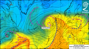
Airmass Analysis chart 06 UTC 6 April 2024: Storm Kathleen moving northwards along the west coast.
The full report is available at https://www.met.ie/climate/past-weather-statements
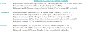
Extreme values for April 2024 at synoptic stations
*Issued by Met Éireann on Thursday 2nd May 2024. This report is based on available preliminary data from 25 principal weather stations operated by Met Éireann. Synoptic station data is midnight to midnight UTC. Long-Term Averages (LTAs) and “average” refer to the period 1981-2010 unless stated. A rain day is a day on which 0.2 mm or more of rainfall is measured. A wet day is a day with 1.0 mm or more of rainfall. A dull day is a day with less than 0.5 hours of sunshine. A very wet day is a day with 10.0 mm or more of rainfall. Climatological dry periods – An absolute drought is a period of 15 or more consecutive days to none of which is credited 0.2 mm or more of precipitation. A partial drought is a period of at least 29 consecutive days, the mean daily rainfall of which does not exceed 0.2 mm. A dry spell is a period of 15 or more consecutive days to none of which is credited 1.0 mm or more of precipitation (i.e. daily tot < 1.0 mm). A heatwave occurs where there are 5 consecutive days or more with maximum temperature over 25°C (that is, a daily maximum screen air temperature > 25° C). The Island of Ireland dataset is 125 years long and runs between 1900 and 2023. For this dataset the long term averages from the 1961-1990 reference period are used for comparison as is standard for long-term climate change assessments. *Sunshine data is from the Autosol Network. LTAs for these sites are currently not used for comparison purposes. For more information, contact Met Éireann at 01-8064200 or e-mail: enq@met.ie