An dara bliain ba theo ar taifead ina raibh báisteach a bhí os cionn an mheáin sa chuid is mó d’áiteanna
Ba í an bhliain 2025 an dara bliain ba theo ar taifead in Éirinn ó bhí 1900 ann agus is iad na ceithre bliana deireanacha na ceithre bliana is teo ar taifead (2022-2025). I mí Eanáir, bhí an bhliain fionnuar ar dtús agus bhí sneachta in áiteanna sular tháinig na gaotha ab airde a taifeadadh riamh le Stoirm Éowyn (fórsa hairicín). Bhí deireadh an gheimhridh te go ginearálta agus bhí an t-earrach ba theo agus ba ghrianmhaire ar taifead agus an samhradh ba theo ar taifead ann ina dhiaidh sin. De bharr córas gluaisteach Atlantach bhí an 4ú fómhar ba fhliche ar taifead ann .
- B’ionann an mheánteocht aeir bhliantúil d’Éirinn in 2025 (agus tacar sonraí Oileán na hÉireann á úsáid) agus 11.14 °C, atá 1.59 °C os cionn an mheáin fhadtéarmaigh (MFT) don tréimhse 1961-1990 nó 0.97 °C os cionn MFT 1991-2020 is déanaí.
- Dá bhrí sin is í an bhliain 2025 an dara bliain is teo ar taifead, atá beagáinín ar chúl na mbliana is teo in 2023 (11.21 °C) agus is í an dara huair atá meán os cionn 11 °C ann.
- Is iad na 4 bliana deireanacha (2022-2025) na 4 bliana is teo ar taifead anois agus tá na blianta 2024 agus 2007 ar comhscór mar an 4ú bliain is teo, agus tharla seacht mbliana de na deich gcinn is teo ó bhí 2005 ann.
- Ba í an bhliain 1919 an bhliain ab fhuaire ar taifead, nuair a bhí 8.73 °C ann, agus maidir leis na deich mbliana ab fhuaire – níor tharla aon cheann acu ó bhí 2000 ann.
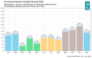
- Go sealadach, tugtar le fios le sonraí báistí gurbh í an bhliain 2025 an 15ú bliain ba fhliche ar taifead ó bhí 1941 ann, 104% de MFT 1991-2020, ina raibh raon breathnaithe 1,338.7 mm.
Staitisticí Aeráide 2025
Bhí mí Eanáir fionnuar agus grianmhar. Bhí sé tirim sa Tuaisceart agus san Iarthar agus fliuch sa Deisceart agus san Oirthear. De bharr aermhais Artach, bhí sneachta sa Deisceart agus san Iarthar go luath sa mhí agus tháinig gaotha fórsa hairicín agus luas nua na gaoithe ab airde riamh le stoirm Éowyn i dtreo dheireadh na míosa. Bhí mí Feabhra séimh. Bhí sé fliuch sa Deisceart ach ní ba thirime sa Tuaisceart. De bharr ardbhrú blocála thar Chríoch Lochlann bhí tréimhsí gaoth aneas i lár na míosa sula raibh gaotha Atlantacha aniar ann den chuid ba mhó ag deireadh na míosa.
Bhí mí an Mhárta séimh, tirim agus grianmhar agus bhí ardbhrú ann le linn an chuid ba mhó den mhí. Bhí mí Aibreáin te agus grianmhar agus bhí uasteochtaí laethúla ab airde riamh le haghaidh mhí Aibreáin ann. Bhí sé tirim sa chéad leath den mhí agus fliuch sa dara leath. Bhí mí na Bealtaine te, tirim, séimh agus grianmhar. Bhí ardbhrú blocála ó thuaidh ó Éirinn ann an chuid ba mhó den mhí.
Bhí mí an Mheithimh an-te tar éis tús fionnuar. De bharr ardbhrú ó thuaidh bhí a lán scamall ann chomh maith le báisteach a bhí os cionn an mheáin sa chuid ba mhó d’áiteanna seachas an Deisceart, áit a raibh ní ba thirime mar gheall ar ardbhrú ilchríochach. Bhí mí Iúil an-te agus bhí báisteach athraitheach ann. De bharr ardbhrú ó dheas agus ísealbhrú ó thuaidh bhí aershreabhadh aniar ann den chuid ba mhó. Bhí na teochtaí ab airde sa bhliain ann de bharr tréimhse the i dtreo lár na míosa. Bhí mí Lúnasa an-te. Bhí sé fliuch i gcodanna den Iarthar ach tirim in áiteanna eile. Bhí ardbhrú ann an chuid ba mhó den mhí. Bhí gálaí láidre ann ag tús na míosa de bharr Stoirm Floris.
Bhí mí Mheán Fómhair fionnuar agus fliuch agus bhí sí ina thús le tréimhse fhada aimsire gluaistí ar a raibh tionchar ag an Atlantach. Bhí Éire ar an taobh thuaidh ní b’fhionnuaire den scairdsruth an chuid ba mhó den am, áit a raibh ísealbhrú i réim. Bhí mí Dheireadh Fómhair séimh, gruama agus fliuch go ginearálta. Le hísealbhrú Atlantach tháinig a lán báistí roimh thréimhse ina raibh ardbhrú an chuid ba mhó den am i lár na míosa agus ina diaidh sin. Tháinig gaotha fórsa stoirme tréine le Stoirm Amy ag tús na míosa. Ba í mí na Samhna an mhí ba fhliche sa bhliain. Bhí ísealbhrú Atlantaigh fós ann den chuid ba mhó. Stad Stoirm Claudia siar ó thuaidh i lár na míosa agus chuir sí leis an iliomad frontaí aimsire gníomhaí thar an tír.
Bhain éagsúlacht leis an aimsir i mí na Nollag agus le hísealbhrú Atlantach tháinig a lán báistí an chuid ba mhó den mhí lena n-áirítear stoirm Bram, sular tháinig ardbhrú chun cinn, rud a chuir críoch thirim leis an mbliain.
Báisteach: Os cionn an mheáin ag formhór na stáisiún, ní ba thirime i gcomparáid leis an meán san Iardheisceart
Bhí an chuid ba mhó de na hiomláin báistí bliantúla os cionn a Meáin Fhadtéarmaigh (MFT) don tréimhse 1991-2020. Bhí na chéad ocht mí den bhliain sách tirim ach bhí na ceithre mhí dheireanacha i bhfad ní ba fhliche.
Bhí an céatadán de na luachanna bliantúla báistí idir 86% (983.2 mm) ag Cionn Mhálanna, Co. Dhún na nGall agus 124% (1322.9 mm) ag Caisleán Bhaile Sheáin, Co. Loch Garman (an dara bliain ba fhliche ar taifead). Bhí na hiomláin báistí bliantúla idir 804.2mm (104% dá MFT) ag Aerfort Bhaile Átha Cliath, Co. Bhaile Átha Cliath agus 1809.4mm (110% dá MFT) ag Réadlann Dhairbhre, Co. Chiarraí.
Ba é an t-iomlán báistí laethúil ab airde ná 66.9 mm ag Caisleán Bhaile Sheáin, Co. Loch Garman Dé hAoine an 14 Samhain (a bhain le stoirm Claudia). Bhí líon na laethanta báistí* idir 184 lá ag Aerfort Bhaile Átha Cliath agus 258 lá ag Baile Uí Fhiacháin, Co. Mhaigh Eo.Bhí líon na laethanta fliucha* idir 134 lá ag Aerfort Bhaile Átha Cliath agus ag Aeradróm Mhic Easmainn, Co. Bhaile Átha Cliath araon, agus 216 lá ag Baile Uí Fhiacháin, Co. Mhaigh Eo. Bhí líon na laethanta an-fhliuch* idir 20 lá ag Páirc an Fhionnuisce agus ag Aerfort Bhaile Átha Cliath, Co. Bhaile Átha Cliath araon agus 66 lá ag Réadlann Dhairbhre, Co. Chiarraí.
Breathnaíodh 64 tréimhse thirim chlíomeolaíochta ar leith* in Éirinn le linn 2025 ag stáisiúin shionoptacha idir Dé Luain an 6 Eanáir 2025 agus Dé Domhnaigh an 24 Lúnasa 2025. Díobh sin, bhí 42 tréimhse thirim* ag 22 stáisiún, bhí 18 dtriomach iomlána ag 16 stáisiún agus bhí 4 thriomach pháirteacha* ag ceithre stáisiún.
Aimhrialtachtaí báistí míosúla greillithe sealadacha le haghaidh 2025 (% de 1991-2020) mar aon le hiomláin báistí míosúla
Teocht: Bhí an dara bliain ba theo nó comhbhliain ba theo ar taifead ag formhór na stáisiún
Bhí na meánteochtaí aeir go léir ar fud na tíre os cionn a MFT bhliantúil agus bhí na trí bliana ba theo ar taifead ag na 25 stáisiún go léir. Bhí an dara bliain ba theo ag ceithre stáisiún déag, agus bhí an chomhbhliain ba theo ar taifead le haghaidh 2025 ag ocht stáisiún.
Bhí athruithe ó mheánteocht an aeir don bhliain idir +0.8 °C ag Béal Átha hÉis, Co. an Chabháin, Béal an Mhuirthead, Co. Mhaigh Eo, Caisleán Bhaile Sheáin, Co. Loch Garman, Inis Arcáin, Co. Chorcaí agus Réadlann Dhairbhre, Co. Chiarraí (meánteochtaí 10.4 °C, 11.3 °C, 11.1 °C, 11.9 °C agus 11.8 °C faoi seach) agus +1.1 °C ag Aeradróm Mhic Easmainn, Co. Bhaile Átha Cliath, Páirc an Fhionnuisce, Co. Bhaile Átha Cliath agus Aerfort Chnoc Mhuire, Co. Mhaigh Eo (meánteochtaí 10.8 °C, 11.1 °C agus 9.9 °C faoi seach). Bhí meánteochtaí don bhliain idir 9.9 °C (1.1 °C os cionn a MFT) ag Aerfort Chnoc Mhuire, Co. Mhaigh Eo agus 11.9 °C (0.8 °C os cionn a MFT) ag Inis Arcáin, Co. Chorcaí.
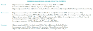
Taifeadadh na teochtaí ab ísle sa bhliain Déardaoin an 9 Eanáir. Tuairiscíodh an íosteocht aeir laethúil ab ísle ag Baile Átha an Rí, Co. na Gaillimhe, arbh ionann í sin agus -7.6 °C, agus ba í an íosteocht féir ab ísle ná -11.8 °C a tuairiscíodh ag an Muileann gCearr, Co. na hIarmhí. Tuairiscíodh an uasteocht laethúil ab airde sa bhliain ag stáisiún sionoptach Dé Sathairn an 12 Iúil ag Cluain Creamha, Co. Ros Comáin, áit a raibh teocht 31.1 °C (B’ionann 32.2 °C agus an teocht ab airde sa bhliain, lena n-áirítear na stáisiúin oifigiúla eile de chuid Met Éireann, a tuairiscíodh ag Páirc Náisiúnta Chonamara Dé Domhnaigh an 13 Iúil).
Tuairiscíodh sioc aeir agus talún i rith na bliana ag gach stáisiún. Bhí líon na laethanta nuair a bhí sioc talún ann idir 32 lá Inis Arcáin, Co. Chorcaí agus 135 lá ag Páirc an Fhionnuisce, Co. Bhaile Átha Cliath. Bhí líon na laethanta nuair a bhí sioc aeir ann idir lá amháin ag cúpla stáisiún agus 45 lá ag Cluain Creamha, Co. Ros Comáin.
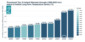
Na 10 mbliana ba theo sealadacha in Éirinn ó bhí 1900 ann ón tsraith teochta fadtéarmaí (°C) de chuid thacar sonraí Oileán na hÉireann*
Taitneamh Gréine: Os cionn an mheáin, ní ba ghrianmhaire san Oirthear agus sa Deisceart
Bhí gach iomlán taitnimh gréine atá ar fáil os cionn a MFT. Bhí an céatadán de na luachanna taitnimh gréine bhliantúil idir 118% (1600.2 uair) ag Aeradróm Mhic Easmainn, Co. Bhaile Átha Cliath agus 119% (1662.5 uair) ag Aerfort na Sionainne, Co. an Chláir. Bhí na hiomláin taitnimh gréine bhliantúil idir 1348.0 uair (Níl comparáid MFT ar fáil*) ag Réadlann Dhairbhre, Co. Chiarraí agus 1721.4 uair (Níl comparáid MFT ar fáil*) ag Caisleán Bhaile Sheáin, Co. Loch Garman.
B’ionann 15.7 uair an chloig ag Cionn Mhálanna, Co. Dhún na nGall Dé Sathairn an 12 Iúil agus an líon ab airde uaireanta taitnimh gréine laethúla a taifeadadh i mbliana. Bhí líon na laethanta gruama* idir 26 lá ag Aerfort Chnoc Mhuire, Co. Mhaigh Eo agus 105 lá ag Réadlann Dhairbhre, Co. Chiarraí.
Gaoth: Bhí tionchar díreach ag cúig stoirm ainmnithe ar Éirinn, tuairiscíodh na gaotha fórsa hairicín nach raibh a leithéid ann riamh le linn stoirm Éowyn
Bhí meánluasanna gaoithe bliantúla idir 10.9 km/u (5.9 muirmhíle san uair) ag stáisiúin iomadúla agus 26.9 km/u (14.5 muirmhíle san uair) ag Ceann Mhása, Co. na Gaillimhe. Bhí laethanta iomadúla ann ina raibh gálaí. Tuairiscíodh gálaí láidre Dé Domhnaigh an 23 Feabhra, Dé Luain an 4 Lúnasa le linn stoirm Floris, Dé Domhnaigh an 14 agus Dé Luain an 15 Meán Fómhair, Déardaoin an 30 Deireadh Fómhair, Dé Domhnaigh an 23 agus Déardaoin an 27 Samhain agus Dé Máirt an 9 Nollaig le linn stoirm Bram. Shroich meánghaotha fórsa stoirme Déardaoin an 23 agus Dé hAoine an 24 Eanáir le linn stoirm Éowyn agus Dé hAoine an 3 agus Dé Sathairn an 4 Deireadh Fómhair le linn stoirm Amy.
Shroich meánluasanna gaoithe fórsa stoirme tréan 11 ag Aerfort Chnoc Mhuire, Co. Mhaigh Eo, Ceann Mhása, Co. na Gaillimhe, Fionnúir, Co. Dhún na nGall agus Cionn Mhálanna, Co. Dhún na nGall Dé hAoine an 24 Eanáir le linn stoirm Éowyn agus ag Cion Mhálanna, Co. Dhún na nGall Dé hAoine an 3 Deireadh Fómhair le linn stoirm Amy. Shroich meánluasanna gaoithe fórsa hairicín 12 ag Cionn Mhálanna, Co. Dhún na nGall agus ag Ceann Mhása, Co. na Gaillimhe Dé hAoine an 24 Eanáir le linn stoirm Éowyn.
Bhí líon na laethanta le gaoth suas le gálaí láidre idir náid lá ag cúpla stáisiún agus 8 lá ag Ceann Mhása, Co. na Gaillimhe. Bhí líon na laethanta le gaotha fórsa stoirme nach mó ná 3 lá ag Ceann Mhása, Co. na Gaillimhe. Tuairiscíodh séideán agus meánluas gaoithe 10 nóiméad na bliana ag Ceann Mhása, Co. na Gaillimhe Dé hAoine an 24 Eanáir le linn stoirm Éowyn. B’ionann an séideán ab airde agus 184 km/u (99.5 muirmhíle san uair) agus b’ionann an meánluas gaoithe 10 nóiméad sa bhliain agus 142 km/u (76.5 muirmhíle san uair) (Luasanna gaoithe sealadacha is airde (leanúnach agus séideán) na hÉireann sa taifead aeráide digiteach).
Tá an tuarascáil iomlán ar fáil anseo (roghnaigh ‘Bliain’ sa roghchlár anuas)
Luachanna foircneacha 2025 ag stáisiúin shionoptacha
Taifid stáisiúin agus teagmhais fhoircneacha mhíosúla in 2025:
Báisteach:
- De bharr aermhais Artach ag tús mhí Eanáir bhí sneachta in áiteanna agus bhí mí Eanáir ba fhliche ó bhí 1998 ann ag Caisleán Bhaile Sheáin, Co. Loch Garman.
- Bhí 7ú mí Feabhra ba fhliche ar taifead ag Aerfort Chorcaí, Co. Chorcaí (fad 64 bliain) agus bhí báisteach os cionn an mheáin d’Éirinn ag 119% de MFT 1991-2020.
- Bhí mí an Mhárta an-tirim agus ní raibh ach 39% de mheán 1991-2000 ann. Bhí mí an Mhárta ba thirime ar taifead ag Dún Samhnaí, Co. na Mí agus ag Ceann Mhása, Co. na Gaillimhe (fad 61 agus 20 bliain).
- Bhí mí an Mhárta ba thirime ó bhí 1953 ann ag Béal Átha hÉis, Co. an Chabháin, bhí mí an Mhárta ba thirime ó bhí 1961 ann ag an nGoirtín, Co. Thiobraid Árann agus bhí mí an Mhárta ba thirime ó bhí 1990 ann ag Aerfort Bhaile Átha Cliath.
- Bhí mí Aibreáin ba fhliche ar taifead ag Aerfort Chnoc Mhuire, Co. Mhaigh Eo, Cluain Creamha, Co. Ros Comáin agus an Goirtín, Co. Thiobraid Árann Dé hAoine an 18 (fad taifead idir 17 mbliana agus 28 bliain). Bhí 113% de MFT 1991-2020 ag deireadh mhí Aibreáin.
- Bhí tréimhsí tirime* ag sé stáisiúin, san Oirthear den chuid ba mhó, idir an 28 Márta agus an 14 Aibreán a mhair idir 15 agus 18 lá.
- Bhí triomach páirteach* ag Aeradróm Mhic Easmainn, Co. Bhaile Átha Cliath a mhair 29 lá agus a tháinig chun deiridh an 12 Aibreán.
- Bhí go leor tréimhsí tirime clíomeolaíochta (*) ann a tháinig chun deiridh i mí na Bealtaine. Bhí tréimhsí tirime* ag fiche stáisiún a mhair idir 15 agus 27 lá. Bhí triomaigh iomlána* ag aon stáisiún déag a mhair idir 15 agus 25 lá. Breathnaíodh triomaigh pháirteacha* a mhair 30 lá ag dhá stáisiún (an Chloch Liath, Co. Chorcaí agus Rinn an Róistigh, Co. Chorcaí. Bhí 71% de MFT 1991-2020 ag deireadh mhí na Bealtaine.
- I mí an Mheithimh bhí báisteach os cionn an mheáin ann ag 117% de MFT 1990-2020.
- I mí Iúil bhí báisteach os cionn an mheáin ann ag 103% de MFT 1990-2020.
- I mí Lúnasa bhí báisteach os cionn an mheáin ann ag 75% de MFT 1990-2020.
- Tar éis mhí Mheán Fómhair bhí roinnt míonna fliucha ann ag 142% de MFT 1991-2020, rud a fhágann gurb í 18u mí Mheán Fómhair is fliche ó bhí 1940 ann. Bhí mí Mheán Fómhair ní ba fhliche ó bhí 2006 ann ag Réadlann Dhairbhre, Co. Chiarraí.
- I mí Dheireadh Fómhair bhí báisteach os cionn an mheáin ann ag 123% de MFT 1990-2020. Bhí mí Dheireadh Fómhair ba fhliche ar taifead ag trí stáisiún Déardaoin an 2.
- Ba í mí na Samhna an mhí ba fhliche sa bhliain agus 5ú mí na Samhna ba fhliche ar taifead ag 136% de MFT 1991-2020. Bhí mí na Samhna ba fhliche ar taifead ag Caisleán Bhaile Sheáin, Co. Loch Garman (fad 84 bliain). Bhí lá ba fhliche na bliana ag Caisleán Bhaile Sheáin, Co. Loch Garman Dé hAoine an 14 Samhain (66.9 mm), a bhain le stoirm Claudia.
- Ba é fómhar 2025 an 4ú fómhar ba fhliche ar taifead ó bhí 1941 ann.
- I mí Dheiredh Fómhair bhí báisteach gar don mheán ann ag 97% de MFT 1990-2020.
Teochtaí:
- Tuairiscíodh lá oighrithe* ag naoi stáisiún Dé Céadaoin an 8 Eanáir agus bhí an íosteocht ab ísle i mí Eanáir ag Caisleán Bhaile Sheáin, Co. Loch Garman ó bhí 2010 ann.
- Ba í mí Feabhra 16ú mí Feabhra ba theo ar taifead (fad 126 bliain).
- Ba í mí an Mhárta 8ú mí an Mhárta ba theo ar taifead. Bhí mí an Mhárta ba theo ó bhí 2012 ann ag trí stáisiún déag agus bhí mí an Mhárta ba theo ó bhí 2017 ann ag dhá stáisiún déag.
- Ba í mí Aibreáin 3ú mí Aibreáin ba theo ar taifead san iomlán agus bhí mí Aibreáin ba theo ar taifead ag Réadlann Dhairbhre, Co. Chiarraí, Béal an Mhuirthead, Co. Mhaigh Eo agus Aerfort Chnoc Mhuire, Co. Mhaigh Eo, rud a bhí mar an gcéanna le 2011 (fad taifid idir 28 bliain agus 85 bliain).
- Tuairiscíodh an uasteocht laethúil ab airde le haghaidh mhí Aibreáin ag seacht stáisiún déag, agus iad go léir Dé Céadaoin an 30, lena n-áirítear Baile Átha an Rí, Co. na Gaillimhe, áit ar tuairiscíodh an uasteocht ab airde ar taifead le haghaidh mhí Aibreáin d’Éirinn, arbh ionann í agus 25.9 °C.
- Ba í mí na Bealtaine 6ú mí na Bealtaine ba theo ar taifead agus bhí mí na Bealtaine ba theo ar taifead ag cúig stáisiún sa Deisceart agus san Iarthar.
- D’fhorbair tonn teasa mhuirí amach ó chósta thiar na hÉireann le linn mhí Aibreáin agus mhí na Bealtaine agus teochtaí dhromchla na farraige ag sroicheadh teochtaí 2°C ní ba theo ná an meán i roinnte ceantair chósta, agus suas le 4°C ní ba thirime ná an meán i gceantair amach ón gcósta .
- Bá é earrach 2025 an t-earrach ba theo ar taifead d’Éirinn agus bhí an t-earrach ba theo ar taifead ag 23 stáisiún de 25 ceann.
- Ba í mí an Mheithimh 4ú mí an Mheithimh ba theo ar taifead d’Éirinn.
- Tuairiscíodh íosteochtaí míosa féilire iomláine ab airde riamh ag Páirc an Fhionnuisce, Co. Bhaile Átha Cliath agus ag Baile an Phaghanaigh, Co. Cheatharlach agus tuairiscíodh íosteochtaí ab airde riamh ag Aerfort Bhaile Átha Cliath, Aeradróm Mhic Easmainn, Co. Bhaile Átha Cliath, Dún Samhnaí, Co. na Mí agus Caisleán Bhaile Sheán, Co. Loch Garman le haghaidh mhí an Mheithimh.
- Ba í mí Iúil 9ú mí Iúil ba theo ar taifead d’Éirinn. Tharla an tréimhse ba theo sa bhliain díreach roimh lár na míosa nuair a shroich roinnt stáisiún níos mó ná 30 °C agus tuairiscíodh an teocht ab airde sa bhliain ag Páirc Náisiúnta Chonamara, arbh ionann í sin agus 32.2 °C, Dé Domhnaigh an 13 Iúil.
- Ba í mí Lúnasa 4ú mí Lúnasa ba theo ar taifead d’Éirinn agus ba í an mhí ba theo iomlán in 2025. Tuairiscíodh mí Lúnasa ba theo ar taifead ag sé stáisiún agus ba í an mhí Lúnasa ab theo í ó bhí 1995 ann ag seacht stáisiún sheanbhunaithe.
- Ba é samhradh 2025 an samhradh ba theo ar taifead d’Éirinn agus bhí an samhradh ba theo ar taifead ag 5 stáisiún agus bhí an samhradh ba theo ó bhí 1995 ann ag cúig stáisiún eile.
- Bhí mí Mheán Fómhair ní b’fhionnuaire ná an meán agus tháinig sraith míonna an-te idir mí Feabhra agus mí Lúnasa chun deiridh ansin.
- Ba í mí Dheireadh Fómhair 24ú mí Dheireadh Fómhair ba theo ar taifead d’Éirinn.
- Ba í mí na Samhna 21ú mí na Samhna ba theo ar taifead d’Éirinn.
- Ba í mí na Nollag 24ú mí na Nollag ba theo ar taifead d’Éirinn. Sáraíodh na huasteochtaí laethúla ab airde ag dhá stáisiún déag le haghaidh mhí na Nollag Dé Máirt an 9 agus stoirm Bram ag dul thart.
Taitneamh Gréine:
- Bhí mí Eanáir ba ghrianmhaire ar taifead ag Aeradróm Mhic Easmainn, Co. Bhaile Átha Cliath (fad 61 bliain).
- I mí Feabhra bhí 11 lá as a chéile gan taitneamh gréine ag Aerfort Bhaile Átha Cliath, Co. Bhaile Átha Cliath (0.0 uair an chloig) idir Dé Sathairn an 8 agus Dé Máirt an 18, arb ionann é sin agus an líon is mó laethanta as a chéile gan taitneamh gréine ag Aerfort Bhaile Átha Cliath (a tharla roimhe seo i mí an Mhárta 1969).
- Bhí an t-iomlán taitnimh gréine mhíosúil ab airde i mí Aibreáin ar taifead (fad 68 bliain) ag Cionn Mhálanna, Co. Dhún na nGall agus bhí an taitneamh gréine laethúil ab airde i mí Aibreáin ar taifead ag Aerfort Bhaile Átha Cliath, Co. Bhaile Átha Cliath Dé Céadaoin an 30 (fad 83 bliain).
- Bhí an mhí féilire ba ghrianmhaire agus mí na Bealtaine ba ghrianmhaire ar taifead ag Aerfort na Sionainne, Co. an Chláir agus ag Béal an Mhuirthead, Co. Mhaigh Eo (faid taifead 79 bliain, 63 bliain agus 68 bliain faoi seach). Bhí an mhí ab ghrianmhaire ag Réadlann Dhairbhre, Co. Chiarraí ó Bhealtaine 1961. Ba í an dara mí na Bealtaine ba ghrianmhaire i ndiaidh 2020 ag Aeradróm Mhic Easmainn agus Aerfort Bhaile Átha Cliath.
- Ba é an tEarrach ba ghrianmhaire ar taifead d’Éirinn.
Gaoth:
- I mí Eanáir, tháinig gaotha fórsa hairicín agus na luasanna gaoithe nua ab airde riamh d’Éirinn agus stoirm Éowyn anseo. Ba é an séideán ab airde ná 99.5 muirmhíle san uair (184 km/u) agus ba é an meánluas gaoithe 10 nóiméad ab airde ná 76.5 muirmhíle (142 km/u), an dá acu a taifeadadh ag Ceann Mhása, Co. na Gaillimhe Dé hAoine an 24 .
- Sáraíodh na séideáin ab airde riamh a bhí ann ag ceithre stáisiún le linn stoirm Éowyn agus sáraíodh an meánluas gaoithe 10 nóiméad ab airde riamh a bhí ann ag ceithre stáisiún.
- Sroicheadh gaotha fórsa hairicín 12 ar scála gaoithe Beaufort ag dhá stáisiún le linn stoirm Éowyn, sroicheadh fórsa stoirme tréine 11 ag ceithre stáisiún agus sroicheadh fórsa stoirme 10 ag ocht stáisiún.
- I mí Lúnasa bhí gálaí láidre ag tús na míosa de bharr Stoirm Floris.
- Tháinig gaotha fórsa stoirme tréine le Stoirm Amy ag tús mhí Dheireadh Fómhair agus taifeadadh an meánluasanna gaoithe 10 nóiméad ab airde ar taifead le haghaidh mhí Dheireadh Fómhair ag cúig stáisiún.
- Tháinig gálaí láidre le Stoirm Bram Dé Máirt an 9 Nollaig.
Comhthéacs an Athraithe Aeráide
Leanann téamh foriomlán in Éirinn ar aghaidh ar aon líne leis an treocht téimh dhomhanda. Tharla seacht mbliana de na deich mbliana ba theo in Éirinn ó bhí 2005 ann, agus is í an bhliain 2025 an dara bliain is teo ar taifead. Maidir le tonn teasa mhuirí eile níos luaithe in 2025 agus teochtaí dhromchla na farraige (TDF) níos airde ná an meán go ginearálta timpeall ár gcóstaí agus trasna an Atlantaigh Thuaidh, cuireann siad le meánteochtaí níos airde ná an meán agus le cion taise méadaithe san atmaisféar thar Éirinn. Cé go raibh 2025 sách tirim go dtí mí Lúnasa, bhí na ceithre mhí dheireanacha an-fhliuch agus tharla an iliomad teagmhas báistí troime a bhí ina gcúis le tuilte forleathana cósta agus abhann.
Dúirt an clíomeolaí Paul Moore: “Tá an treocht téimh an-soiléir agus is iad na ceithre bliana deireanacha na ceithre bliana is teo ar taifead in Éirinn, ó bhí 1900 ann. Ní hamháin go raibh an t-earrach ba theo in 2025, ach bhí an samhradh ba theo ar taifead ann freisin, agus chuir ardteochtaí i rith na hoíche leis an taifead samhraidh sin. Bhí cúig stoirm ainmnithe in 2025, chomh maith le roinnt teagmhais bháistí a raibh tionchar acu. Mar gheall ar an téamh leanúnach tá baol méadaitheach ann go mbeidh teagmhais adhaimsire ann.”
Léiríonn na réamh-mheastacháin is déanaí in Éirinn maidir le hathrú aeráide go mbeidh tuilleadh téimh amach anseo. Ciallaíonn an t-athrú teochta seo go bhfuil méadú tagtha ar an dóchúlacht go dtarlóidh tarluithe adhaimsire. Meastar go n-athróidh patrúin bháistí na hÉireann, le méadú ar thréimhsí tirime agus ar imeachtaí titime báistí troma araon. Leanann leibhéil na farraige ag ardú ar fud an domhain. Mar thoradh air sin, meastar go dtiocfaidh méadú ar an mbaol borrtha stoirme agus tuilte cósta timpeall chóstaí na hÉireann chomh maith le ‘hilteagmhais’ a bhaineann le báisteach throm agus taoidí arda le chéile. Cuireann an t-athrú aeráide le stoirmeacha de bharr uiscí níos teo agus tuilleadh taise san atmaisféar agus léirítear i staidéir go mbeidh stoirmeacha den sórt a tharla san am atá caite (e.g. Ophelia) níos cumhachtaí, níos láidre agus níos scriosaí i ndomhan níos teo.
*Issued by Met Éireann on Tuesday 6th January 2026. This report is based on available preliminary data from 25 principal weather stations operated by Met Éireann. Synoptic station data is midnight to midnight UTC. Long-Term Averages (LTAs) and “average” refer to the period 1991-2020 unless stated. A rain day is a day on which 0.2 mm or more of rainfall is measured. A wet day is a day with 1.0 mm or more of rainfall. A dull day is a day with less than 0.5 hours of sunshine. A very wet day is a day with 10.0 mm or more of rainfall. Climatological dry periods – An absolute drought is a period of 15 or more consecutive days to none of which is credited 0.2 mm or more of precipitation. A partial drought is a period of at least 29 consecutive days, the mean daily rainfall of which does not exceed 0.2 mm. A dry spell is a period of 15 or more consecutive days to none of which is credited 1.0 mm or more of precipitation (i.e. daily tot < 1.0 mm). A heatwave occurs where there are 5 consecutive days or more with maximum temperature over 25°C (that is, a daily maximum screen air temperature > 25° C). An icing day occurs at a station when the daily maximum air temperature falls below 0°C. The ‘Island of Ireland’ dataset is 126 years long and runs between 1900 and 2025. For this dataset the long term averages from the 1961-1990 reference period are used for comparison as is standard for long-term climate change assessments. *Sunshine data is from the Autosol Network. LTAs for these sites are currently not used for comparison purposes. For more information, contact Met Éireann at 01-8064200 or e-mail: enq@met.ie