An bhliain is teo a taifeadadh riamh, báisteach faoin meán
Bhí mí Eanáir séimh agus an-tirim. Sa chéad trian den mhí, bhí córais lagbhrú an Atlantaigh i dtreis, agus sna dhá thrian deiridh, bhí ardbhrú ó dheas i réim. Ghluais Stoirm Corrie agus Stoirm Malik gar do thuaisceart na tíre i dtreo dheireadh na míosa. Mí shéimh, fhliuch agus ghaofar ab ea mí Feabhra, faoi smacht ag córais ardbhrú an Atlantaigh. Stiúir scairdsruth láidir trí stoirm ainmnithe, Dudley, Eunice agus Franklin, gar don tír nó os a cionn i lár na míosa, rud ba chúis leis an tréimhse is gaofaire den bhliain. Bhí Márta, an mhí is tirime de mhíonna an earraigh, faoi smacht ag an ardbhrú soir thar mhórthír na hEorpa, rud a thug go leor gréine agus a d’fhág na teochtaí a bheith séimh. Bhog an t-ardbhrú go tuaisceart na hÉireann i rith mhí Aibreáin, rud a chloígh leis an aimsir a bheith níos crua, níos séimhe agus níos grianmhaire ná an meán. Bhí mí na Bealtaine te, sách tirim agus scamallach. Bhí smacht ag an ardbhrú uaireanta, le tréimhsí ina raibh smacht ag an lagbhrú freisin ina orlaí tríd. Ba mhí réasúnta séimh í mí an Mheithimh, le smacht ag aimsir an Atlantaigh agus aershreabh aneas agus aniar ann go príomha. D’fhág sé seo an aimsir a bheith níos fliche, níos fionnuaire agus níos scamallaí san Iarthar agus níos tirime, níos teo agus níos grianmhara san Oirthear. D’fhorbair ardbhrú ó na hAsóir os cionn na hÉireann i mí Iúil agus mí Lúnasa, rud a d’fhág an aimsir a bheith níos teo agus níos tirime ná an meán. Mar thoradh ar aermhais ilchríochach the, bhí uasteocht laethúil nua taifeadta i mí Iúil, agus bhí uasteocht laethúil nua taifeadta i mí Lúnasa mar thoradh ar thonnta teasa. Bhí trí mhí an fhómhair, Meán Fómhair, Deireadh Fómhair, agus Samhain, níos fliche ná an meán, le tréimhsí fada lagbhrú amach ó Iarthar agus Iardheisceart na hÉireann. D’fhág sé seo go raibh an aershreabh ag teacht aneas agus aniar go príomha, rud a thug teochtaí níos séimhe ná an meán. I mí na Nollag, an t-aon mhí den bhliain a raibh teochtaí faoin meán ann, bhí tréimhse fhuar fhada faoi aermhais Artach le linn chéad leath na míosa, agus ina dhiaidh sin bhí an tAtlantach i dtreis don dara leath.
Báisteach: Faoin meán ag formhór na stáisiún
Bhí formhór na n-iomlán titime báistí bliantúil ar fud na tíre faoi Mheánleibhéal Fadtéarmach (MLFT) 1981-2010. Bhí céatadán na luachanna titime báistí bliantúla idir 90% (iomlán báistí bliantúil de 1068.6 mm agus 1124.0 mm) ag Inis Arcáin, Co. Chorcaí agus Fionnúir Co. Dhún na nGall faoi seach, go 107% (an t-iomlán bliantúil titime báistí is airde sa bhliain de 1678.7 mm) ag Réadlann Dhairbhre, Co. Chiarraí. Ba ag Aerfort Bhaile Átha Cliath, Co. Bhaile Átha Cliath, a bhí an t-iomlán titime báistí bliantúil is ísle ag 688.2 mm (céatadán MLFT 91%). Ba é an t-iomlán titime báistí laethúil ab airde ná 54.9 mm ag Aerfort Chorcaí, Co. Chorcaí ar an Domhnach 16ú (an luach laethúil is airde ó 2005). Bhí líon na laethanta báistí idir 183 lá ag Aerfort Bhaile Átha Cliath, Co. Bhaile Átha Cliath agus 273 lá ag Cionn Mhálanna, Co. Dhún na nGall. Bhí líon na laethanta fliucha idir 125 lá ag Baile an Phaghanaigh, Co. Cheatharlach agus 203 lá ag Baile Uí Fhiacháin, Co. Mhaigh Eo. Mhéadaigh líon na laethanta an-fhliuch ó 17 lá ag Aerfort Bhaile Átha Cliath, Co. Bhaile Átha Cliath go 65 lá ag Réadlann Dhairbhre, Co. Chiarraí. Ba í an bhliain ba thirime ó 2011 i leith ag Aerfort Chorcaí agus ag Rinn an Róistigh, Co. Chorcaí araon. Tugadh 47 tréimhse thirime ar leith (dearbhthriomach, páirt-triomach agus tréimhsí tirime) faoi deara in Éirinn le linn 2022. Ba thréimhsí tirime iad 42 acu seo ag 21 stáisiún agus ba dhearbhthriomach iad 5 acu seo ag cúig stáisiún.
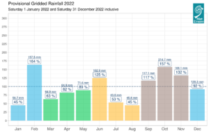
Provisional monthly gridded 2022 rainfall (%) for Ireland on a monthly basis
Teocht: Os cionn an mheáin i ngach áit, an bhliain is teo riamh ar an iomlán
Bhí meánteocht an aeir ar fud na tíre os cionn an MLFT don bhliain. Bhí athruithe ó mheánteocht an aeir don séasúr idir 0.2 °C (9.9 °C meánteocht) ag Marcréidh, Co. Shligigh go 1.2 °C (10.8 °C meánteocht) ag Páirc an Fhionnuisce, Co. Bhaile Átha Cliath. Bhí meánteocht na bliana idir 9.5 °C (0.9 °C os cionn a MLFT) ag Aerfort Chnoc Mhuire, Co Mhaigh Eo (an bhliain is teo ó 2007) agus 11.7 °C (0.6 °C os cionn a MLFT) ag Inis Arcáin, Co. Chorcaí (an fómhar is teo ó 2004). Tuairiscíodh an teocht is airde i mbliana i bPáirc an Fhionnuisce, Co. Bhaile Átha Cliath Dé Luain an 18 Iúil le teocht de 33.0 °C (an dara teocht is airde a taifeadadh riamh in Éirinn agus an ceann is airde ó 1887). Taifeadadh an íosteocht aeir agus féir ab ísle i mbliana ag Cluain Creamha, Co Ros Comáin agus tuairiscíodh an teocht aeir ab ísle Dé hAoine an 16 Nollaig ag -8.8 °C (an íosteocht ab ísle ó 2009, agus an íosteocht ab ísle in Éirinn ó mhí na Nollag 2010), agus ba é -13.0 °C an íosteocht féir ab ísle (an íosteocht féir ab ísle i mí na Nollag a taifeadadh riamh (fad 17 mbliana) a tuairiscíodh Dé Céadaoin an 14 Nollaig. Tuairiscíodh sioc aeir agus talún i rith na bliana ag gach stáisiún. Bhí líon na laethanta le sioc talún idir 34 lá ag Béal an Mhuirthead, Co. Mhaigh Eo agus 153 lá ag Cluain Creamha, Co. Ros Comáin. Ba é líon na laethanta nuair a bhí sioc aeir ann ná 2 lá ag Cionn Mhálanna, Co. Dhún na nGall go 62 lá ag Cluain Creamha, Co. Ros Comáin. Ba í an bhliain ba theo riamh í ag ocht stáisiún (fad taifid idir 10 agus 57 bliain). Ba í an bhliain ba theo ó 2007 í ag naoi stáisiún. Thuairiscigh deich stáisiún an uasteocht laethúil is airde a taifeadadh riamh, naoi stáisiún Dé Luain an 18 Iúil agus stáisiún amháin Dé Sathairn an 13 Lúnasa. Tuairiscíodh tonnta teasa ag seacht stáisiún idir an Mháirt an 9 agus an Domhnach an 14 Lúnasa, a mhair idir 5 agus 6 lá. Tríd is tríd, is é 10.83°C meánteocht an aeir scáthaithe in Éirinn in 2022, atá 1.28°C os cionn an MLFT idir 1961 agus 1990. Mar sin, is í 2022 an bhliain is teo riamh, 0.06°C níos teo ná 2007 an bhliain is teo roimhe sin.
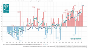
Aimhrialtacht teochta d’Éirinn. Is é 10.83°C meánteocht an aeir scáthaithe in Éirinn in 2022, atá 1.28°C os cionn an MLFT idir 1961 agus 1990
Taitneamh gréine: Taitneamh gréine ba ghrianmhaire san Oirthear
Bhí iomláin an taitnimh gréine ar fad a bhí ar fáil os cionn an Mheánleibhéil Fhadtéarmaigh (MLFT). Bhí céatadán na luachanna taitnimh gréine bliantúla idir 115% (taitneamh gréine bliantúil iomlán de 1501.0 uair an chloig) ag Aerfort na Sionainne, Co. an Chláir go 121% (taitneamh gréine bliantúil iomlán de 1651.3 uair an chloig) ag Aeradróm Mhic Easmainn, Co. Bhaile Átha Cliath (an bhliain is grianmhaire a taifeadadh taifead (fad 54 bliain). Bhí an t-iomlán taitnimh gréine bliantúil idir 1274.8 uair an chloig (Níl comparáid MLFT ar fáil*) ag Béal an Mhuirthead, Co. Mhaigh Eo agus 1713.7 uair an chloig (Níl comparáid MLFT ar fáil*) ag Caisleán Bhaile Sheáin, Co. Loch Garman. Ba é 16.1 uair an chloig ag Cionn Mhálanna, Co. Dhún na nGall ar an Satharn an 4 Meitheamh an líon is airde uaireanta an chloig gréine laethúla a taifeadadh an bhliain seo. Bhí líon na laethanta idir 65 lá ag Aerfort Bhaile Átha Cliath, Co. Bhaile Átha Cliath agus 94 lá ag Béal an Mhuirthead, Co. Mhaigh Eo.
Gaoth: Cúig stoirm ainmnithe a raibh tionchar díreach acu ar Éirinn, gaotha fórsa stoirme tréana tuairiscithe le linn stoirme Eunice
Bhí an meánluas gaoithe bliantúil na gaoithe idir 5.9 muirmhíle san uair (10.9 km/u) ag an gCloch Liath, Co. Chorcaí agus 14.9 muirmhíle san uair (27.6 km/u) ag Cionn Mhálanna, Co. Dhún na nGall. Bhí go leor laethanta ann le gálaí agus gálaí láidre le gaotha nach mó ná gaotha fórsa stoirme Dé Sathairn an 1 Eanáir i mBéal an Mhuirthead, Co. Mhaigh Eo, Dé hAoine an 18 Feabhra ag Rinn an Róistigh, Co. Chorcaí le linn Stoirm Eunice, Dé Domhnaigh an 20 agus Dé Luain an 21 Feabhra ag Cionn Mhálanna, Co. Dhún na nGall, Ceann Mhása, Co. na Gaillimhe agus Fionnúir, Co. Dhún na nGall le linn Stoirm Franklin agus Dé Céadaoin an 23 Samhain ag Ceann Mhása, Co. na Gaillimhe. Tuairiscíodh gaotha fórsa stoirme tréana Dé hAoine, an 18 Feabhra, i rith stoirm Eunice ag Rinn an Róistigh, Co. Chorcaí. Bhí líon na laethanta le gaotha nach mó ná gálaí láidre idir lá ar bith ag formhór na stáisiún agus 17 lá ag Ceann Mhása, Co. na Gaillimhe. Bhí líon na laethanta le gaotha fórsa stoirme nach mó ná 3 lá ag Ceann Mhása, Co. na Gaillimhe. Ba é lá amháin líon na laethanta le gaotha fórsa stoirme tréana ag Rinn an Róistigh, Co. Chorcaí. Tuairiscíodh an séideán is airde den bhliain ag Ceann Mhása, Co. na Gaillimhe, Dé Domhnaigh an 20 Feabhra, séideán a bhí cothrom le 75 muirmhíle (139 km/u). Bhí an meánluas gaoithe 10 nóiméad is airde den bhliain cothrom le 57 muirmhíle (106 km/u) ag Rinn an Róistigh, Co. Chorcaí ar an 18 Feabhra.
Tá an tuarascáil iomlán ar fáil anseo (roghnaigh ‘Bliain’ sa roghchlár anuas).
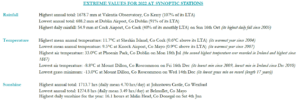
2022 extreme values at synoptic stations
Taifid Náisiúnta: Briseadh na taifid uasteochta ab airde riamh le haghaidh mhí Iúil agus mhí Lúnasa in 2022; i bPáirc an Fhionnuisce Dé Luain an 18 Iúil (33.0°C atá 12.9°C os cionn an mheáin fhadtéarmaigh (MFT) a bhí ann idir 1981-2010) agus i nDarú, Co. Laoise Dé Sathairn an 13 Lúnasa (32.1°C).
Taifid stáisiúin, tonnta teasa agus laethanta oighir:
- Bhí an uasteocht is airde do mhí Eanáir a taifeadadh riamh ag deich stáisiún ar Lá Caille, an Satharn an 1 Eanáir (fad taifid idir 11 agus 72 bliain).
- Thaifead Aerfort Bhaile Átha Cliath an Márta ba ghrianmhaire riamh le 203.1 uair an chloig (fad taifid 81 bliain).
- Taifeadadh an Bhealtaine is teo a taifeadadh riamh i dtrí stáisiún. Ba ag na stáisiúin seo a leanas a bhí siad: Páirc an Fhionnuisce, Co. Bhaile Átha Cliath le meánteocht de 12.9 °C (2.1 °C os cionn a MLFT) (fad taifid 123 bliain), Dún Samhnaí, Co. na Mí ag 12.2 °C (1.7 °C os cionn a MLFT) (fad taifid 29 bliain) agus Baile Átha an Rí, Co. na Gaillimhe ag 12.3 °C (0.9 °C os cionn a MLFT) (fad taifid 12 bhliain). Taifeadadh an Bhealtaine is teo ar taifead riamh ag Cionn Mhálanna, Co. Dhún na nGall, ag 11.9 °C (1.6 °C os cionn a MLFT), ar comhscór le 2008 (fad taifid 67 bliain).
- Thuairiscigh naoi stáisiún an uasteocht laethúil is airde, d’aon mhí, a taifeadadh riamh, agus ba é Dé Luain an 18 Iúil a bhí i ngach ceann acu. Ba iad sin: Aeradróm Mhic Easmainn, Co. Bhaile Átha Cliath (fad taifid 58 bliain) ag 31.9°C, Cluain Creamha, Co. Ros Comáin (fad 14 bliana) ag 31.4°C, an Goirtín, Co. Thiobraid Árann (fad 14 bliana) ag 31.0°C, Baile Átha hÉis, Co. an Chabháin (fad 17 mbliana) ag 30.8°C, Baile Átha an Rí, Co. na Gaillimhe (fad 12 bhliain) agus Dún Samhnaí, Co. na Mí (fad 48 bliain) ag 30.5°C, an Muileann gCearr, Co. na hIarmhí (fad 72 bliain) ag 30.4°C agus Aerfort Bhaile Átha Cliath, Co. Bhaile Átha Cliath (fad 80 bliain) ag 29.6°C. Bhí an uasteocht laethúil is airde a taifeadadh riamh do mhí Iúil ag stáisiún amháin. Ba ag Aerfort na Sionainne, Co. an Chláir a bhí sí (fad 76 bliain) le 30.8°C.
- Tuairiscíodh tonnta teasa ag seacht stáisiún idir an Mháirt an 9 agus an Domhnach an 14 Lúnasa, a mhair idir 5 agus 6 lá. Ba acu seo a leanas a bhí siad: Aerfort na Sionainne, Co. an Chláir, Aerfort Chorcaí, Co. Chorcaí, Páirc an Fhionnuisce, Co. Bhaile Átha Cliath, Dún Samhnaí, Co. na Mí (5 lá), Baile an Phaghanaigh, Co. Cheatharlach, an Chloch Liath, Co. Chorcaí agus Aeradróm Mhic Easmainn, Co. Bhaile Átha Cliath (6 lá).
- Sháraigh aon stáisiún déag a dtaifid uasteochta do mhí Lúnasa. Ba iad sin: Baile an Phaghanaigh, Co. Cheatharlach ag 31.7°C (fad taifid 18 mbliana), Aerfort na Sionainne, Co. an Chláir ag 30.0°C (fad taifid 76 bliain), Cluain Creamha, Co. Ros Comáin ag 29.2°C (fad taifid 7 mbliana), an Goirtín, Co. Thiobraid Árann ag 28.9°C (fad taifid 14 bhliana), Baile Átha an Rí, Co. na Gaillimhe ag 28.5°C (fad taifid 12 bhliain), Baile Uí Fhiacháin, Co. Mhaigh Eo ag 28.5°C (fad taifid 62 bliain), Aerfort Chorcaí, Co. Chorcaí ag 28.3°C (fad 60 bliain), Marcréidh, Co. Shligigh ag 28.3°C (fad taifid 17 mbliana), Ceann Mhása, Co. na Gaillimhe ag 27.4°C (fad taifid 18 mbliana) agus Fionnúir, Co. Dhún na nGall ag 26.5°C (fad 11 bhliain). Sháraigh stáisiún amháin, an Chloch Liath, Co. Chorcaí, an taifead teochta is airde riamh aige i mí Lúnasa le 30.6 °C (fad taifid 35 bliain).
- Bhí an Deireadh Fómhair is fliche riamh ag seacht stáisiún. Ba iad seo An Chloch Liath, Co. Chorcaí le 230.4 mm (fad taifid 58 bliain), Aerfort Chnoc Mhuire, Co. Mhaigh Eo le 217.5 mm (fad taifid 25 bliain), Cluain Creamha, Co. Ros Comáin le 182.8 mm (fad taifid 18 mbliana), Goirtín, Co. Thiobraid Árann le 159.8 mm (fad taifid 14 bliana), An Muileann gCearr, Co. na hIarmhí le 208.8 mm (fad taifid 72 bliain), Béal Átha hÉis, Co. an Chabháin le 205.2 (fad taifid 7 mbliana) agus Ceann Mhása, Co. na Gaillimhe le 209.3 mm (fad taifid 14 bliana).
- Bhí an Deireadh Fómhair is teo riamh ag cúig stáisiún (fad taifid idir 11 agus 18 mbliana).
- Bhris cheithre stáisiún déag a dtaifead íosteochta laethúil ab airde do mhí na Samhna ar an Aoine 11 Samhain, le taifead nua íosteochta laethúil is airde d’Éirinn i mí na Samhna de 14.9°C a taifeadadh ag Aerfort na Sionainne, Co. an Chláir.
- Bhí an uasteocht is airde riamh i mí na Samhna i bhFionnúir, Co. Dhún na nGall, le 17.6°C (fad taifid 25 bliain)
- Bhí LÁ OIGHIR ag aon stáisiún déag (nuair nach n-ardaíonn an teocht uasta in aon lá os cionn 0.0 °C) Dé Luain an 12 Nollaig 2022, agus bhí an dara lá oighir as a chéile ag ceithre cinn de na stáisiúin sin ar an 13 agus bhí an tríú lá oighir as a chéile ag stáisiún amháin, Béal Átha hÉis, Co. an Chabháin Dé Céadaoin an 14.
- Bhí an fómhar ba fhliche a taifeadadh riamh ag Réadlann Dhairbhre, Co. Chiarraí (fad taifid 81 bliain) le 786.5 mm (167% dá MLFT).
Blianta Beaga Anuas in Éirinn:
- 2016: Bhí luachanna titime báistí bliantúla Meánleibhéal Fadtéarmach (MLFT) athraitheach, thuairiscigh formhór na stáisiún a MLFT bliantúil nó os a chionn le haghaidh meánteochtaí agus bhí ocht stoirm ainmnithe ann.
- 2017: Bhí an teocht agus an bháisteach gar don mheán, bhí beagnach gach iomlán bliantúil gréine faoin MLFT ama agus bhí sé stoirm ainmnithe ann, lena n-áirítear stoirm Ophelia i mí Dheireadh Fómhair.
- 2018: Bhí an Teocht agus an Taitneamh Gréine os cionn an mheáin i bhformhór na n-áiteanna; bhí sé níos tirime ná mar is gnách ag dhá thrian de na stáisiúin agus bhí deich stoirm ainmnithe ann, lena n-áirítear stoirm Emma go luath i mí an Mhárta.
- 2019: Titim báistí os cionn an mheáin, teochtaí beagán os cionn an mheáin, bhí líon na hiomláin taitnimh gréine athraitheach agus tuairiscíodh gaotha fórsa stoirme le linn roinnt de na seacht stoirm ainmnithe.
- 2020: Titim báistí, teochtaí agus luachanna taitnimh gréine os cionn an mheáin, le naoi stoirm ainmnithe.
- 2021: Teocht os cionn an mheáin agus luachanna taitnimh gréine le titim báistí faoi bhun an mheáin agus bhí cúig stoirm ainmnithe ann.
Comhthéacs maidir leis an Athrú Aeráide
Lean treocht téimh na hÉireann ar aghaidh in 2022, agus táimid ag téamh i gcomhréir leis an meán domhanda. Tá tíortha eile ag téamh ar ráta níos mó ná Éire agus bhí iliomad tonnta teasa agus teochtaí ab airde riamh ar fud na hEorpa agus ar fud an domhain i samhradh na bliana 2022. Bhí an t-earrach agus an samhradh in 2022 ní ba thirime ná an meán in Éirinn, rud a raibh iarmhairtí diúltacha aige don talmhaíocht agus don tsochaí i gcoitinne.
Léirítear leis na réamh-mheastacháin is déanaí maidir leis an athrú aeráide in Éirinn go mbeidh tuilleadh téimh sa todhchaí, samhraí níos tirime ar an meán agus seans méadaithe go mbeidh tonnta teasa agus tréimhsí triomaigh ann. Tá samhradh 2022 in Éirinn ag teacht go ginearálta le treochtaí réamh-mheasta don todhchaí. Cé go léirítear le réamh-mheastacháin maidir leis an athrú aeráide treocht i dtreo geimhrí níos teo, ní féidir tréimhsí fuara amhail iad siúd a tharla i mí na Nollag seo caite a chur as an áireamh in aon bhliain ar leith.
Dúirt Keith Lambkin, Ceann Rannóg Seirbhísí Aeráide Met Éireann, an méid seo a leanas: “D’athraigh an t-athrú aeráide an seans go mbeidh teagmhais ann níos minice a bhaineann le teas níos déine. Mar gheall ar bhreis agus céad bliain de bhreathnuithe tiomnaithe aimsire anseo in Éirinn, tá a fhios againn go raibh adhaimsir in 2022 a bhris taifid agus is dócha gurb í an bhliain is teo a taifeadadh riamh in Éirinn. Tá sé ríthábhachtach go gcaithfimid leanúint ar aghaidh ag dul in oiriúint chun a chinntiú go bhfuil ár mbonneagair náisiúnta agus ár bpleanáil oiriúnach don téamh reatha agus don téamh amach anseo.”