Cuimhníodh ar shamhradh 1976 in Éirinn agus sa Ríocht Aontaithe mar shamhradh fada te. Cé go dtarlaíonn imeachtaí aimsire aonair laistigh de chomhthéacs na hathraitheachta nádúrtha aeráide, tá fianaise shoiléir láidir ann anois go bhfuil an domhan ag téamh agus gurb iad gníomhaíochtaí an duine an phríomhchúis leis an athrú aeráide le déanaí.
Dé Luain, an 22 Meitheamh 2026
Ó 1976 i leith, bhí dhá shamhradh eile in Éirinn inar taifeadadh meánteochtaí foriomlána níos airde: 1995 agus 2025 (fíor 1). Mar sin féin, tá gá le hanailís níos cuimsithí chun a léiriú cén fáth nach bhfuil i samhradh na bliana 1976 ach an tríú samhradh is teo, agus aird á tabhairt ar an gcaoi a bhfuil cuimhne air sa bhéaloideas mar shamhradh fada te. Anseo, déanaimid comparáid idir na trí shamhradh is teo in Éirinn.
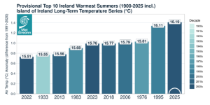
Fíor 1: Na 10 samhradh ba theo a taifeadadh in Éirinn, ina léirítear meánteocht an tsamhraidh iomlán do gach bliain agus an aimhrialtacht (°C) i gcomparáid le meán fadtéarmach na hÉireann don tréimhse 1991-2020.
Samhraí na hÉireann in 1976, 1995 agus 2025
Difríochtaí sa Scála Sionoptach:
Bhí patrúin atmaisféaracha ar mhórscála an-chosúil le linn samhraí 1976 agus 1995; bhí airde geo-acmhainneachta a bhí ard ar bhealach neamhghnách suite díreach os cionn na hÉireann agus díreach ó thuaidh di (figiúr 2). Léiríonn sé seo go raibh ardbhrú i gceannas le linn an dá shamhradh sin, rud a d’fhág gur samhraí grianmhara agus tirime a bhí iontu trí chéile. I gcodarsnacht leis sin, taifeadadh na haimhrialtachtaí ba mhó maidir le hairde geo-acmhainneachta laisteas d’Éirinn i rith shamhradh 2025, agus taifeadadh aimhrialtachtaí ísle lastuaidh di. Léiríonn sé seo go raibh samhradh 2025 níos athraithí; thug an t-ardbhrú ó dheas aimsir níos teo agus níos tirime leis in amanna, agus thug an lagbhrú ó thuaidh tréimhsí níos fliche agus níos scamallaí leis freisin.
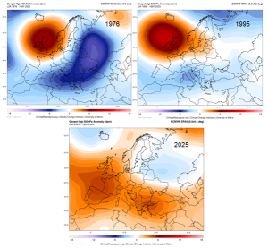
Fíor 2: ERA5 500hPa Aimhrialtacht Airde Geo-acmhainneachta do na trí shamhradh is teo in Éirinn. Baineann na sonraí go léir a thaispeántar le míonna Meithimh, Iúil agus Lúnasa na bliana i gceist. Ar chlé ag an mbarr: 1976, ar dheis ag an mbarr: 1995, agus ag an mbun: 2025.
Tomhais Teochta
Léiríonn na huasteochtaí, meánteochtaí agus íosteochtaí gnéithe éagsúla de dháileadh na teochta, agus cuireann an bháisteach an comhthéacs taise ar fáil a theastaíonn chun coinníollacha an tsamhraidh a léirmhíniú. Le chéile, tugann na tomhais seo léargas níos iomláine ar thaifead aeráide an tsamhraidh in Éirinn.
- Léiríonn an uasteocht an téamh a tharlaíonn i rith an lae agus cabhraíonn sí le monatóireacht a dhéanamh ar dhálaí foircneacha teasa, strus teirmeach, dálaí aimsire a bhaineann le dóiteáin agus ar athruithe sa téamh i rith an lae.
- Léiríonn an íosteocht an fuarú a tharlaíonn san oíche agus tá sí tábhachtach sa samhradh maidir le strus teirmeach san oíche.
- Tugann an mheánteocht achoimre ar na coinníollacha iomlána, ach d’fhéadfadh sí athruithe tábhachtacha a cheilt, amhail oícheanta níos teo, laethanta níos fuaire, nó athruithe sna luachanna foircneacha.
- Léiríonn an bháisteach cé acu i gcoinníollacha tirime nó fliucha a tharla an teas. Bíonn tionchair an-difriúil ag samhradh te tirim, samhradh te fliuch agus samhradh fionnuar fliuch.
- Tarlaíonn tonn teasa in Éirinn nuair a bhíonn 5 lá as a chéile nó níos mó ann a bhfuil an uasteocht os cionn 25°C (is é sin, uasteocht laethúil an aeir scáthláin > 25° C).
Ní hionann an tuairim atá ag gach duine faoi cé chomh “taitneamhach” is atá samhradh. D’fhéadfadh na teochtaí ab airde agus na coinníollacha ba thirime a bheith oiriúnach do ghníomhaíochtaí áirithe, ach d’fhéadfaidís strus teirmeach, brú triomaigh agus coinníollacha deacra a chruthú don talmhaíocht, don soláthar uisce, don dúlra agus don tsláinte.
Príomhfhigiúirí ó shamhradh 1976:
- Ba í an tonn teas ab fhaide a taifeadadh in Éirinn ná tonn teasa 14 lá, ón Satharn an 14 Lúnasa go dtí an Aoine an 27 Lúnasa 1976 (an dá lá san áireamh), ag Caisleán Bhiorra, Contae Uíbh Fhailí (uasteocht 28.2°C) agus ag Baile Briotais, Contae Laoise (uasteocht 29.5°C).
- Níos luaithe an samhradh sin, bhí tonn teasa ann a mhair naoi lá i gCill Chainnigh, Co. Chill Chainnigh, ag tosú Dé Domhnaigh an 27 Meitheamh 1976, áit ar ardaigh an teocht go 31.5 °C Dé Máirt an 29 Meitheamh 1976.
- Ba é 1976 an samhradh ba thirime ar taifead (thar thréimhse 85 bliain), agus meánbháisteach 139.6 mm ann.
- Ba é 32.5 °C an teocht ab airde in Éirinn san fhichiú haois, rud a taifeadadh i mBuarach, Co. Uíbh Fhailí, Dé Máirt an 29 Meitheamh 1976.
- Bhí 21 lá as a chéile ann le teocht os cionn 20.0 °C i gCill Chainnigh, ag tosú Dé Sathairn an 7 Lúnasa 1976.
Príomhfhigiúirí ó shamhradh 1995:
- Bhí tonn teasa ann a mhair ocht lá ag Aerfort na Sionainne, Co. an Chláir, ón Aoine an 23 Meitheamh 1995, agus d’ardaigh an teocht go 30.2 °C Déardaoin an 29 Meitheamh 1995.
- Níos déanaí an samhradh sin, bhí tonn teasa ann a mhair sé lá ag Aerfort na Sionainne, i gCill Chainnigh agus ag Caisleán Bhiorra, Co. Uíbh Fhailí. D’ardaigh an teocht go 30.8 °C i gCill Chainnigh Dé Céadaoin an 2 Lúnasa 1995.
- Bhí 34 lá as a chéile ann le teocht os cionn 20.0 °C ag Aeradróm Mhic Easmainn, Co. Bhaile Átha Cliath, ag tosú Dé Luain an 24 Iúil 1995.
- Ba é 1995 an dara samhradh ba thirime ar taifead (thar thréimhse 85 bliain), agus meánbháisteach 143.1 mm ann.
Príomhfhigiúirí ó shamhradh 2025:
- Ní raibh aon tonn teasa ann i rith shamhradh 2025. Bhí ceithre lá samhraidh (teocht os cionn 25 °C) as a chéile ann ag Cluain Creamha, Contae Ros Comáin, agus shroich an teocht 31.1 °C ansin Dé Sathairn, an 12 Iúil 2025.
- Bhí 20 lá as a chéile ann le teocht os cionn 20.0 °C ag an gCloch Liath, Contae Chorcaí, ag tosú Déardaoin, an 7 Lúnasa 2025.
- Ba é seo an 57ú samhradh ba thirime ar taifead (tréimhse 85 bliain), agus meánbháisteach 278.3 mm ann.
| Samhradh Meitéareolaíoch | 1976 | 1995 | 2025 |
| Uasteochtaí Aeir (°C) (sonraí greillithe ó 1961 i leith) |
An Tríú Ceann is Teo 20.1 °C Fíor-the |
An Ceann is Teo 20.9 °C Fíor-the |
Na hOcht gCinn Is Teo 19.6 °C Te |
| An tSraith Mheánteochta Fhadtéarmach d’Oileán na hÉireann (°C) (1900-2025 san áireamh) |
An Tríú Ceann is Teo 15.8 °C Fíor-the |
An Dara Ceann is Teo 16.1 °C Fíor-the |
An Ceann is Teo 16.2 °C Fíor-the |
| Íosteochtaí Aeir (°C) (sonraí greillithe ó 1961) |
An Fichiú Ceann is Teo 10.7 °C Os cionn an Ghnáthleibhéil |
An Tríú Ceann is Teo 11.5 °C Fíor-the |
An Ceann is Teo 12.0 °C Fíor-the |
| Báisteach (mm) (greillithe ó 1941) |
Is Tirime 139.7 mm Fíor-thirim |
An Dara Ceann Is Tirime 143.1 mm Fíor-thirim |
An 57ú Ceann is Tirime 278.3 mm Os cionn an Ghnáthleibhéil |
Tábla 1. Tábla . Meánluachanna aeráide náisiúnta maidir le teocht agus báisteach do na blianta 1976, 1995 agus 2025
Réamh-mheastacháin do Shamhraí Amach Anseo in Éirinn
Bunaithe ar réamh-mheastacháin aeráide TRANSLATE de chuid Met Éireann, táthar ag súil go méadóidh líon na dtonnta teasa agus na dteochtaí foircneacha in Éirinn de réir mar a rachaidh an céad ar aghaidh. Beidh méid na n-athruithe seo ag brath ar astaíochtaí domhanda gás ceaptha teasa sa todhchaí, ach léiríonn gach cás aeráide go leanfar den téamh. Táthar ag súil go dtiocfaidh méadú ar uasteochtaí agus ar íosteochtaí araon i rith an tsamhraidh, chomh maith le líon níos mó de ‘Laethanta Samhraidh’. Táthar ag súil freisin go mbeidh oícheanta teo (teochtaí os cionn 15 °C) níos coitianta, rud a laghdóidh an fuarú a tharlaíonn thar oíche agus a thugann faoiseamh le linn aimsir the faoi láthair.
Tá i bhfad níos mó éiginnteachta ag baint le réamh-mheastacháin maidir le meánbháisteach an tsamhraidh ná leis na réamh-mheastacháin a bhaineann le hathruithe teochta. Sa chomhthéacs sin, ciallaíonn ‘éiginnte’ go léiríonn na samhlacha a sholáthraíonn réamh-mheastacháin bháistí don todhchaí raon níos leithne d’athruithe a d’fhéadfadh tarlú amach anseo. Léiríonn réamh-mheastacháin maidir le himeachtaí báistí bliantúla níos foircní (amhail an bháisteach uasta laethúil nó an bháisteach thar thréimhse cúig lá) treocht mhéadaitheach níos comhsheasmhaí i dtreo dheireadh an chéid.
Tá an cumas sna hathruithe seo rioscaí don tsláinte phoiblí, don bhonneagar, d’acmhainní uisce, don talmhaíocht agus d’éiceachórais a mhéadú, rud a leagann béim ar an tábhacht a bhaineann le bearta oiriúnaithe chun an athléimneacht i leith teochtaí foircneacha sa todhchaí a fheabhsú.