Warmer than average July for Ireland, with variable rainfall nationwide
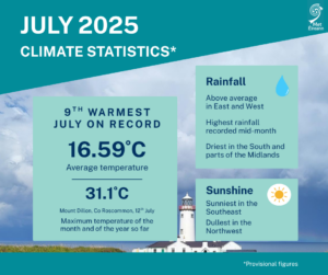
July 2025 was the 9th warmest July and 12th warmest of any month in 126 years of records (using the Island of Ireland dataset*), with an average temperature of 16.59 °C, which is 1.74 °C above the 1961-1990 long-term average (LTA) for July and 1.21 °C above the more recent 1991-2020 LTA.
A build-up of the Azores High over Ireland resulted in plenty of sunshine and a hot spell from July 10th to Sunday 13th, in which temperatures surpassed 27 °C on each day. Rainfall was unevenly distributed across the country during the month, with levels well above average in parts of the East and West, and well below average in parts of the South and north Midlands.
Key Figures:
- July 2025 was the warmest month of 2025 so far and the hottest July since 2021 (which had a mean temperature of 16.83 °C).
- Continuing the recent warmer-than-normal monthly trend, this is the 5th consecutive month with temperatures in the respective top 9 averages on record in 126 years of records.
- Of the top ten warmest July’s, five have occurred since 2001 (2013, 2006, 2021, 2025, 2018).
- July 2025 observed an average of 96.0 mm rainfall, which is slightly above average at 103% of the 1991-2020 LTA, the wettest July since 2023 and 33rd wettest overall since 1941.
July 2025 Statistics
July 2025 was warm with close to average rainfall overall. High pressure to the south and low pressure to the north brought a predominantly westerly airflow.
The first week began relatively cool with high pressure to the south in control. By mid-week, a low-pressure system to the north brought frontal rain and introduced a warmer airmass across the country. Toward the end of the week, high pressure in the southwest began to build northward once again.
The second week saw the Azores high building north over the country bringing lots of sunshine and increasing temperatures. This culminated in a hot spell, where temperatures surpassed 27 °C on each day between Thursday 10th and Sunday 13th. A thundery breakdown followed late on Sunday 13th and through the day on Monday 14th as low pressure began to push in from the Atlantic.
The third week saw slow-moving low pressure systems meandering close to or over Ireland with frontal rain and/or heavy thundery downpours affecting different parts of the country each day. An active weather front stalled over the eastern half of the country Monday 21st bringing a prolonged spell of heavy rainfall to parts of the East.
The fourth week was drier as high pressure built to the south again. Low pressure to the north continued to steer weak weather fronts across the country at times in a westerly airflow. This setup, which continued to the end of the month, brought cloudy misty periods with light rain at times, especially for the West, interspersed with drier and brighter periods, especially for the Midlands and East.
Rainfall: Above average in parts of the East and West, below average in the South and parts of the Midlands
Monthly rainfall values were variable across the country. Rainfall was unevenly distributed across the country with parts of the East and West seeing well above average rainfall while areas in the South and north Midlands saw well below average rainfall. This was due to a combination of weather fronts stalling and the convective nature of the rainfall at times.
Percentage of 1991-2020 Long-Term Average (LTA) rainfall values ranged from 49% (the month’s lowest monthly rainfall total of 40.7 mm) at Ballyhaise, Co Cavan to 161% (monthly rainfall total of 95.7 mm) at Casement Aerodrome, Co Dublin. Monthly rainfall totals were as much as 148.3 mm (144% of its LTA) at Athenry, Co Galway. The highest daily rainfall total was 55.4 mm at Dunsany, Co Meath on Monday 21st (its highest daily fall for July on record (length 61 years) and 79% of its monthly LTA).
The number of rain days* ranged from 11 days at Roches Point, Co Cork to 25 days at Belmullet, Co Mayo. The number of wet days* ranged from 7 days at a few stations to 18 days at Valentia Observatory, Co Kerry. The number of very wet days* ranged from zero days at Moore Park, Co Cork to 6 days at Athenry, Co Galway.
Along with Dunsany, Casement Aerodrome, Co Dublin also had its wettest July day on record on Monday 21st with 50.9 mm (length 61 years). Gurteen, Co Tipperary had its wettest July day on record on Tuesday 15th with 28.3 mm (length 17 years). Three stations, Oak Park, Co Carlow, Johnstown Castle, Co Wexford and Roches Point, Co Cork, had dry spells* between June 27th and July 14th lasting between 15 and 17 days.
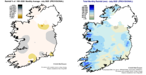
Rainfall % of 1991 – 2020 Monthly Average for July 2025 (Provisional) Total Monthly Rainfall (mm) for July 2025 (Provisional)
Temperature: Above average everywhere, with record high July temperatures in the Northwest
All mean air temperatures across the country were above their LTA for the month. Deviations from mean air temperature ranged from +0.6 °C (15.9 °C mean temperature) at Valentia Observatory, Co Kerry to +1.6 °C (17.1 °C, 17.3 °C mean temperature) at Moore Park, Co Cork and Phoenix Park, Co Dublin respectively. Mean temperatures for the month ranged from 15.3 °C (1.4 °C above its LTA) at Knock Airport, Co Mayo to 17.3 °C at both Phoenix Park, Co Dublin (1.6 °C above its LTA) (its warmest July since 2013) and Oak Park, Co Carlow (1.5 °C above its LTA). The month’s lowest temperatures were recorded on Wednesday 2nd. The lowest air minimum was reported at Claremorris, Co Mayo with a temperature of 4.8 °C and the lowest grass minimum was reported at Markree, Co Sligo with 0.0 °C.
The highest maximum was reported on Saturday 12th, during a hot spell, at Mount Dillon, Co Roscommon with a temperature of 31.1 °C. This was Mount Dillon’s 2nd highest maximum temperature on record, and the highest temperature recorded in Ireland since Friday 12th August 2022, when Oak Park, Co Carlow reported 31.7 °C (the highest August daily maximum temperature on record for Ireland). Two other stations also surpassed 30 °C on Saturday 12th during the hot spell this month. These were Oak Park, Co Carlow with 30.2 °C and Shannon Airport, Co Clare with 30.6 °C, while Mullingar, Co Westmeath reached 30.0 °C. Two stations recorded their highest July maximum temperatures on record, also on Saturday 12th. These were Malin Head, Co Donegal with 27.6 °C (length 70 years) and Knock Airport, Co Mayo with 28.7 °C (length 28 years), while Finner, Co Donegal with 29.6 °C (length 14 years) saw its highest maximum temperature on record for any month. Three stations had their highest mean minimum temperature for July on record reflecting the high nighttime temperatures through the month. There was no air or ground frost reported this month.
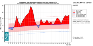
Oak Park, Co Carlow Temperature: Daily mean departure from LTA for July 2025 based on 09-09hr Max/Min values.
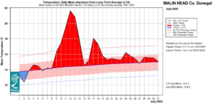
Malin Head, Co Donegal Temperature: Daily mean departure from LTA for July 2025 based on 09-09hr Max/Min values.
Sunshine: Sunny 1st half, dull 2nd half. Sunniest in the Southeast, dullest in the Northwest
Sunshine values were variable across the country. Percentage of monthly sunshine values ranged from 101% (monthly sunshine total of 155.2 hours) at Casement Aerodrome, Co Dublin to 114% (monthly sunshine total of 155.1 hours) at Shannon Airport, Co Clare. The highest monthly sunshine total of 189.7 hours was reported at Johnstown Castle, Co Wexford (no LTA comparison*). Monthly sunshine totals were lowest at Knock Airport, Co Mayo with 93.8 hours (no LTA comparison*). The highest number of daily sunshine hours recorded this month was 15.7 hours at Malin Head, Co Donegal on Saturday 12th. The number of dull days* ranged from 1 day at both Dublin Airport and Casement Aerodrome, Co Dublin to 9 days at Malin Head, Co Donegal.
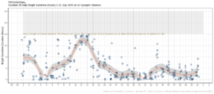
Hours of Bright Sunshine observed at nine stations for each day of the month of July 2025, grouped by province relative to the highest number of hours possible by end of month (shaded box).
Wind: Not significantly strong
Monthly mean wind speeds ranged from 4.8 knots (8.9 km/h) at Ballyhaise, Co Cavan to 12.6 knots (23.3 km/h) at Malin Head, Co Donegal. There were no days with gales, strong gales or storms reported this month. The month’s highest gust was reported at both Mace Head, Co Galway and Sherkin Island, Co Cork on Friday 4th and Tuesday 15th, respectively with 41 knots (76 km/h). The highest 10-minute wind speed was 33 knots (61 km/h) reported at Mace Head, Co Galway on Friday 4th.
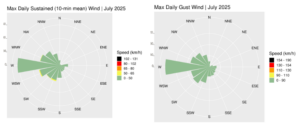
Wind roses for July 2025, sustained 10-min mean and gust.
Full PDF report and charts are available here
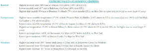
Extreme values for July 2025 at synoptic stations.
Notes to Editor:
- *Issued by Met Éireann on Tuesday 5th August 2025. This report is based on available preliminary data from 25 principal weather stations operated by Met Éireann. Synoptic station data is midnight to midnight UTC. Long-Term Averages (LTAs) and “average” refer to the period 1991-2020 unless stated.
- A rain day is a day on which 0.2 mm or more of rainfall is measured. A wet day is a day with 1.0 mm or more of rainfall. A dull day is a day with less than 0.5 hours of sunshine. A very wet day is a day with 10.0 mm or more of rainfall.
- Climatological dry periods – An absolute drought is a period of 15 or more consecutive days to none of which is credited 0.2 mm or more of precipitation. A partial drought is a period of at least 29 consecutive days, the mean daily rainfall of which does not exceed 0.2 mm. A dry spell is a period of 15 or more consecutive days to none of which is credited 1.0 mm or more of precipitation (i.e. daily tot < 1.0 mm).
- A heatwave occurs where there are 5 consecutive days or more with maximum temperature over 25°C (that is, a daily maximum screen air temperature > 25° C).
- The ‘Island of Ireland’ dataset is 125 years long and runs between 1900 and 2023. For this dataset the long term averages from the 1961-1990 reference period are used for comparison as is standard for long-term climate change assessments.
- Sunshine data is from the Autosol Network. LTAs for these sites are currently not used for comparison purposes.
- For more information or interview opportunities with a Met Éireann spokesperson, please contact us at enq@met.ie.