A heavy rainfall event is expected to affect Ireland tomorrow, Friday 14th November 2025 for an approximate 24h period until midday Saturday 15th November.
Issued on Thursday, 13th November 2025, valid until further notice
OVERVIEW
A weather front is forecast to travel north over southern and eastern parts of Ireland. The rain is the main feature of this event, occurring after a long period of heavy rain over the west and south of Ireland this week, which means the rain will fall on saturated grounds and over swollen rivers.
In addition to the rain, northeasterly winds will develop over Ireland, especially near the east coast. The direction of the wind is expected to compound impacts in eastern coastal counties allowing the rain to essentially ‘pack up’ against the high ground in these counties.
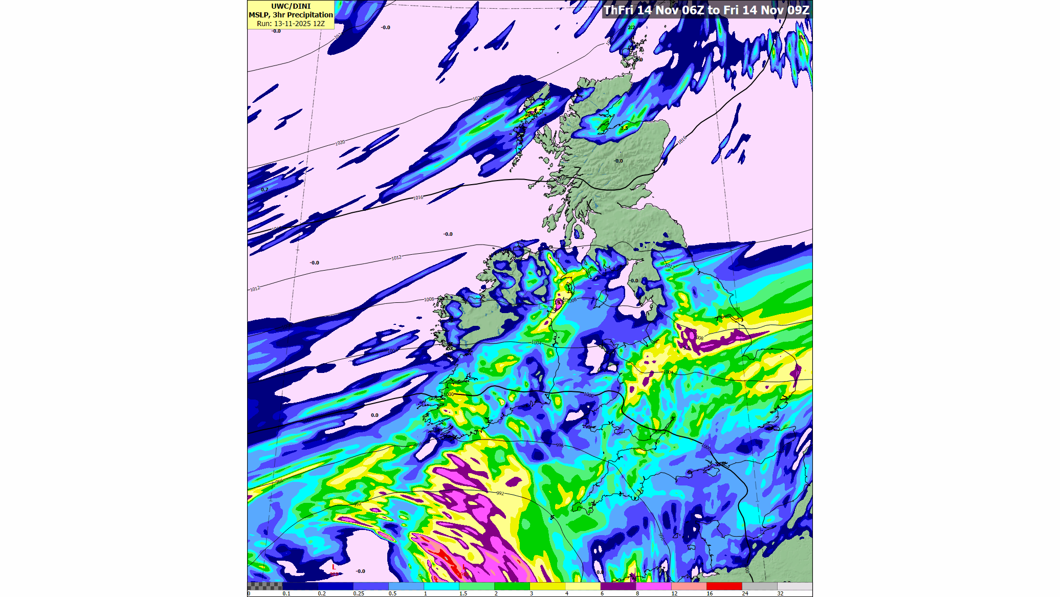
Meteorologist Liz Walsh says “It’s going to rain a lot over parts of Leinster and Munster tomorrow (Friday) while it’ll stay largely dry for many parts of Connacht and Ulster. This rain is brought to us by a weather front derived from Storm Claudia, named earlier in the week by the Spanish met service, and it will fall on already saturated ground and swollen rivers, intensifying the likelihood of significant flooding across Leinster and Munster.
Coupled with the rain, the northeasterly direction of the wind is expected to bring compound impacts in eastern coastal counties, allowing the rain to essentially ‘pack up’ against the high ground in these counties.
Some large accumulations of rain are expected and that’s why we have issued an orange rain warning. We ask people to be cautious, avoid unnecessary travel as it can be hazardous and with poor visibility, and to stay updated on our website or app, signing up to warnings notifications.”
WARNINGS and IMPACTS:
Both yellow and orange rainfall warnings and yellow wind warnings have been issued for Friday and into the weekend. The warnings may be updated (other counties added, timings modified, etc) as new model runs are analysed, however it’s not expected at this point to increase the level of the wind warnings to orange.
- Significant flooding possible: River and surface water flooding is expected in Leinster and Munster on Friday and into the weekend, in part due to the recent rainfall earlier this week which has led to saturated grounds and swollen rivers, combined with the upcoming heavy rainfall expected. Large rivers across Leinster and Munster may overflow banks, while smaller rivers and streams may flood more rapidly.
- Intense rainfall even over a short period may overwhelm urban drainage systems.
- Hazardous, dangerous travelling conditions especially in areas under orange warning, difficult conditions under yellow warnings.
- Poor visibility.
- Debris, displaced objects.
We are closely monitoring the situation and will provide updated information as required. For complete and up to date information on the warnings please check Warnings & Advisories – Met Éireann – The Irish Meteorological Service
METEOROLOGICAL SITUATION
The air flow over the North Atlantic has become increasingly blocked over the last few days with a slow-moving area of high pressure near Greenland and a slow-moving low pressure system to the southwest of Ireland.
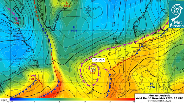
The low-pressure system to the southwest of Ireland was named Storm Claudia by the Spanish Meteorological Agency (AEMET) on Tuesday 10th November, for wind and rain impacts that it brought to the Canary Islands and is currently bringing to western parts of Iberia. Storm Claudia has been influencing our weather all week, feeding weather fronts northwards over the country. On Friday the 14th November, a weather front associated with Storm Claudia is expected to travel north over southern and eastern parts of Ireland. This frontal zone is expected to stall or ‘get stuck’ over us as the area of high pressure coming from Greenland moves closer to us, bringing lower temperatures and more stable weather to Ireland for the start of next week.
HOW TO STAY SAFE IN SEVERE WEATHER – BE WINTER READY
- Stay up-to date with the forecast and the warnings for your county on met.ie, the Met Éireann app or Met Éireann socials (@meteireann).
- Check in with your local authority and emergency management stakeholders (Irish Coast Guards, Gardaí, etc) via their websites and social channels to see how your area will be/is affected.
- Significant flooding possible in Leinster and Munster – stay away from swollen rivers, streams and flooded riverbanks – banks can collapse without warning.
- Avoid open riverbanks and canal paths in flood conditions – water levels and currents may be far stronger than usual.
- Slow down, increase stopping distances and watch for surface water and debris on roads
- If the road ahead is flooded, do not enter – turn around and find another route.
- Avoid contact with floodwater where possible; it may be contaminated with sewage, chemicals or sharp debris.
- Don’t try to walk, cycle or drive through flooded areas, the depth of the water can be deceiving.
- Remember: As little as 150mm of fast-flowing water can knock you off your feet and 300mm of fast-flowing water can move most cars off the road.
- Stay away from coastal areas, the Irish Coast Guard are appealing to people to “Stay Back, Stay High, Stay Dry”.
- Farmers in affected areas are advised to move vehicles, machinery and livestock to higher ground before flooding arrives, where possible.
- Ensure your mobile is phone is fully charged to enable communication in advance of the event and keep local emergency numbers in your phone.
- Keep a small amount of food, medical and water supplies in case it’s dangerous to step out of the home.
- ESB Networks is highlighting the dangers posed by fallen live wires and is advising the public and the emergency services to stay away from these fallen cables and to report such cases to it immediately. ESB Emergency Services can be contacted at 1800 372 999. Monitor PowerCheck.ie in regards to power restoration times.
- Advance planning for flooding: You can consult the OPW flood maps, which show areas that may be at risk of flooding based on historical data (see www.floodinfo.ie).
- “Be Winter Ready”: Follow recommendations before, during and after the event on gov.ie – Be Winter Ready (www.gov.ie)
NOTE THAT:
The warnings are likely to be updated. Please keep in touch with Met Éireann’s social media channels, www.met.ie and the Met Éireann app to stay up to date with the forecast and any warnings’ updates.
The timing and location of extreme weather occurrences can significantly affect their impact. It’s important to note that in any individual weather event, not every location within a warning area may experience the same degree of weather or impacts.
When severe weather is expected, weather and impacts at lower levels are also likely to be experienced. The type and level of impacts can be strongly affected by previous weather conditions. When issuing a warning, Met Éireann takes into consideration the forecasted conditions and thresholds, as well as previous weather conditions that may increase the level of impact expected for particular areas.
——————-ends ————————————————————-
Heavy rain affecting Ireland on Friday 14th November 2025, associated with Storm Claudia
A heavy rainfall event is expected to affect Ireland tomorrow, Friday 14th November 2025 for an approximate 24h period until midday Saturday 15th November.
Issued on Thursday, 13th November 2025, valid until further notice
OVERVIEW
A weather front is forecast to travel north over southern and eastern parts of Ireland. The rain is the main feature of this event, occurring after a long period of heavy rain over the west and south of Ireland this week, which means the rain will fall on saturated grounds and over swollen rivers.
In addition to the rain, northeasterly winds will develop over Ireland, especially near the east coast. The direction of the wind is expected to compound impacts in eastern coastal counties allowing the rain to essentially ‘pack up’ against the high ground in these counties.
Meteorologist Liz Walsh says “It’s going to rain a lot over parts of Leinster and Munster tomorrow (Friday) while it’ll stay largely dry for many parts of Connacht and Ulster. This rain is brought to us by a weather front derived from Storm Claudia, named earlier in the week by the Spanish met service, and it will fall on already saturated ground and swollen rivers, intensifying the likelihood of significant flooding across Leinster and Munster.
Coupled with the rain, the northeasterly direction of the wind is expected to bring compound impacts in eastern coastal counties, allowing the rain to essentially ‘pack up’ against the high ground in these counties.
Some large accumulations of rain are expected and that’s why we have issued an orange rain warning. We ask people to be cautious, avoid unnecessary travel as it can be hazardous and with poor visibility, and to stay updated on our website or app, signing up to warnings notifications.”
WARNINGS and IMPACTS:
Both yellow and orange rainfall warnings and yellow wind warnings have been issued for Friday and into the weekend. The warnings may be updated (other counties added, timings modified, etc) as new model runs are analysed, however it’s not expected at this point to increase the level of the wind warnings to orange.
We are closely monitoring the situation and will provide updated information as required. For complete and up to date information on the warnings please check Warnings & Advisories – Met Éireann – The Irish Meteorological Service
METEOROLOGICAL SITUATION
The air flow over the North Atlantic has become increasingly blocked over the last few days with a slow-moving area of high pressure near Greenland and a slow-moving low pressure system to the southwest of Ireland.
The low-pressure system to the southwest of Ireland was named Storm Claudia by the Spanish Meteorological Agency (AEMET) on Tuesday 10th November, for wind and rain impacts that it brought to the Canary Islands and is currently bringing to western parts of Iberia. Storm Claudia has been influencing our weather all week, feeding weather fronts northwards over the country. On Friday the 14th November, a weather front associated with Storm Claudia is expected to travel north over southern and eastern parts of Ireland. This frontal zone is expected to stall or ‘get stuck’ over us as the area of high pressure coming from Greenland moves closer to us, bringing lower temperatures and more stable weather to Ireland for the start of next week.
HOW TO STAY SAFE IN SEVERE WEATHER – BE WINTER READY
NOTE THAT:
The warnings are likely to be updated. Please keep in touch with Met Éireann’s social media channels, www.met.ie and the Met Éireann app to stay up to date with the forecast and any warnings’ updates.
The timing and location of extreme weather occurrences can significantly affect their impact. It’s important to note that in any individual weather event, not every location within a warning area may experience the same degree of weather or impacts.
When severe weather is expected, weather and impacts at lower levels are also likely to be experienced. The type and level of impacts can be strongly affected by previous weather conditions. When issuing a warning, Met Éireann takes into consideration the forecasted conditions and thresholds, as well as previous weather conditions that may increase the level of impact expected for particular areas.
——————-ends ————————————————————-
Eolas Fúinn