Geimhreadh 2021/2022 (Nollaig, Eanáir, Feabhra)
Geimhreadh níos séimhe ná mar is gnách (staitisticí sealadacha)
- Ba é Geimhreadh 2022 an 6ú geimhreadh is teo le 123 Geimhreadh
- Bhí Geimhreadh níos teo sna blianta seo: 1943, 1975, 1989, 1998, 2019
- An 7ú Geimhreadh as a chéile, ag nó os cionn an mheáin (1961-1990)
- Mhéadaigh teochtaí geimhridh in Éirinn faoi 0.65°C ó 1900
- Sa 5% is airde do Theochtaí Geimhridh, rud a chiallaíonn gur geimhreadh níos séimhe ná mar is gnách a bhí ann
An-séimh, titim báistí díreach os cionn an mheáin ar an iomlán, gaofar ag uaireanta
Chabhraigh guairneán polach strataisféarach láidir le hAscalú an Atlantaigh Thuaidh a choimeád dearfach den chuid is mó i rith gheimhreadh 2021/22, seachas ar feadh tréimhse sa dara leath de mhí na Nollag nuair a bhrúigh ardbhrú thar an Ghraonlainn na córais lagbhrú san Atlantach níos faide ó dheas. Is éard is ciall leis sin ná, d’fhormhór an gheimhridh, gur fhan Scairdsruth an Atlantaigh Thuaidh ó thuaidh, le hÉirinn ar an taobh ó dheas, a bhí níos teo. Mar gheall air sin, d’fhan na rianta stoirme lagbhrú ó thuaidh agus in iarthar na hÉireann den chuid is mó, le hardbhrú ó dheas. Bhí mí na Nollag séimh le smacht ag an lagbhrú sa chéad agus tríú trian den mhí, rud a thug titim báistí os cionn an mheáin leis. Bhí titim báistí faoi bhun an mheáin sa dara trian den mhí agus smacht ag an ardbhrú. Thug Stoirm Bharra, ainmnithe ag Met Éireann, gaotha diana léi ar an Máirt, an 7 Nollaig, agus ar an gCéadaoin, an 8 Nollaig. Bhí smacht ag an ardbhrú i ndeisceart agus in oirthear na hÉireann i mí Eanáir, rud a thug dálaí séimhe agus tirime leis. Thug dhá stoirm gaotha láidre leo agus iad ag gluaiseacht thar thuaisceart an oileáin i dtreo dheireadh na míosa. Stoirm Malik, ainmnithe ag DMI (an Danmhairg), ar an Satharn an 29 Eanáir agus Stoirm Carrie, ainmnithe ag an Oifig Mheitéareolaíochta (RA), ar an Domhnach an 30 Eanáir. Bhí mí Feabhra séimh agus fliuch le smacht ag an lagbhrú ón tuaisceart. Thug trí stoirm, iad ar fad ainmnithe ag an Oifig Mheitéareolaíochta (RA), gaotha láidre go diana leo i mí Feabhra. Stoirm Dudley ar an gCéadaoin an 16 Feabhra, Stoirm Eunice ar an Aoine an 18 Feabhra agus Stoirm Franklin ar an Domhnach an 20 Feabhra agus ar an Luan an 21 Feabhra.
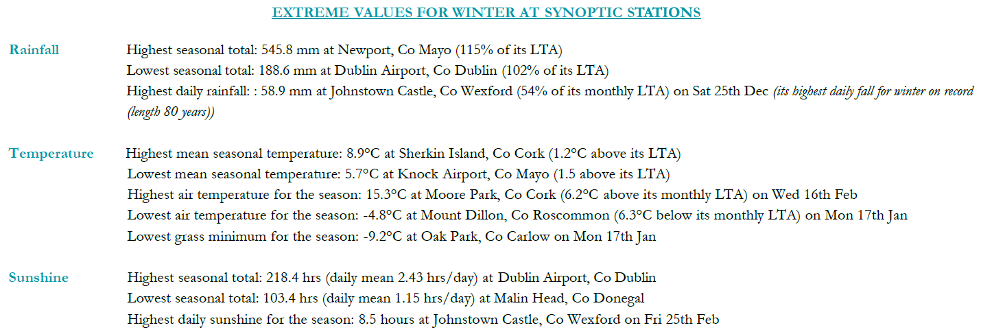
Titim Báistí: Díreach os cionn an mheáin ar an iomlán, an méid is ísle san Iardheisceart
Bhí céatadán de luachanna Meánleibhéil Fhadtéarmaigh (MLFT) do thitim báistí athraitheach ar fud na tíre. Bhí céatadán na luachanna titime báistí séasúracha idir 76% (iomlán titime báistí séasúrach de 276.0 mm) ag Inis Arcáin, Co. Chorcaí agus 119% ag an Muileann gCearr, Co. na hIarmhí (iomlán titime báistí séasúrach de 307.4 mm) agus ag Cionn Mhálanna, Co. Dhún na nGall (iomlán titime báistí séasúrach de 385.6 mm). Bhí iomláin shéasúracha na titime báistí don séasúr idir 188.6mm (102% dá MLFT) ag Aerfort Bhaile Átha Cliath, Co. Bhaile Átha Cliath agus 545.8mm (115% dá MLFT) ag Baile Uí Fhiacháin, Co. Mhaigh Eo. Ba é iomlán laethúil na titime báistí is airde ná 58.9 mm ag Caisleán Bhaile Sheáin, Co. Loch Garman ar an Satharn an 25 Nollaig (an titim laethúil is airde don gheimhreadh ar taifead (fad 80 bliain)). Bhí líon na laethanta báistí idir 51 lá ag cúpla stáisiún agus 77 lá ag Béal an Mhuirthead, Co. Mhaigh Eo. Bhí líon na laethanta fliucha1 idir 32 lá ag Aerfort Bhaile Átha Cliath, Co. Bhaile Átha Cliath agus 62 lá ag Baile Uí Fhiacháin, Co. Mhaigh Eo. Bhí líon na laethanta an-fhliuch3 idir 4 lá ag Baile an Phaghanaigh, Co. Cheatharlach agus 18 lá ag Baile Uí Fhiacháin, Co. Mhaigh Eo. Bhí sealanna triomaigh6 ag naoi stáisiún idir an Satharn an 8 Eanáir agus an Domhnach an 30 Eanáir.
Teocht: Os cionn an mheáin i ngach áit, níos séimhe ná mar is gnách
Bhí meánteocht an aeir ar fud na tíre os cionn an Mheánleibhéil Fhadtéarmaigh (MLFT) don séasúr. Bhí athruithe ó mheánteocht an aeir idir 0.8 °C (meánteocht 6.2 °C) ag Aerfort Bhaile Átha Cliath, Co. Bhaile Átha Cliath agus 1.8 °C (meánteocht 7.2 °C) ag Fionnúir, Co. Dhún na nGall. Bhí meánteochtaí an tséasúir idir 5.7 °C (1.5 °C os cionn a MLFT) ag Aerfort Chnoc Mhuire, Co. Mhaigh Eo agus 8.9 °C (1.2 °C os cionn a MLFT) ag Inis Arcáin, Co. Chorcaí. Ba iad teochtaí is ísle an tséasúir ar taifead ná an Luan an 17 Eanáir leis an íosmhéid aeir is ísle ar taifead ag Cluain Creamha, Co. Ros Comáin le teocht de -4.8 °C agus an t-íosmhéid féir is ísle ar taifead ag Baile an Phaghanaigh, Co. Cheatharlach le -9.2 °C. Tuairiscíodh an t-uasmhéid is airde ar an gCéadaoin an 16 Feabhra ag an gCloch Liath, Co. Chorcaí le teocht de 15.3 °C. Thuairiscigh gach stáisiún sioc talún i rith an tséasúir. Bhí líon na laethanta le sioc talún idir 7 lá ag Béal an Mhuirthead, Co. Mhaigh Eo agus 55 lá ag Páirc an Fhionnuisce, Co. Bhaile Átha Cliath. Thuairiscigh níos mó ná leath na stáisiún sioc aeir. Bhí líon na laethanta le sioc aeir idir náid lá ag cúpla stáisiún agus 16 lá ag an Muileann gCearr, Co. na hIarmhí.
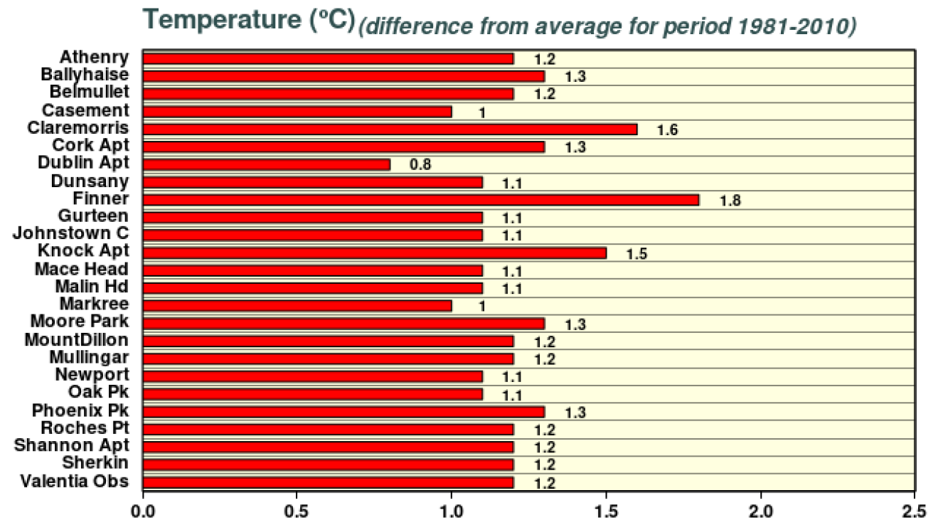
Difríochtaí i meánteochtaí Gheimhreadh 2021/2022
Taitneamh na Gréine: Neamhlonrach san Iarthuaisceart, taitneamh gréine is mó san Oirthear agus san Oirdheisceart
Bhí céatadán na luachanna taitnimh gréine séasúracha idir 112% (taitneamh gréine séasúrach iomlán de 181.4 uair an chloig) ag Aerfort na Sionainne, Co. an Chláir agus 113% (taitneamh gréine séasúrach iomlán de 195.5 uair an chloig) ag Aeradróm Mhic Easmainn, Co. Bhaile Átha Cliath. Bhí iomláin shéasúracha an taitnimh gréine idir 103.4 uair an chloig (Níl comparáid MLFT ar fáil*) ag Cionn Mhálanna, Co. Dhún na nGall agus 218.4 uair an chloig (Níl comparáid MLFT ar fáil*) ag Aerfort Bhaile Átha Cliath, Co. Bhaile Átha Cliath. Ba é 8.5 uair an chloig ag Caisleán Bhaile Sheáin, Co. Loch Garman, ar an Aoine an 25 Feabhra an líon is airde uaireanta an chloig gréine laethúla a taifeadadh an séasúr seo. Bhí líon na laethanta gruama2 idir 28 lá ag Aerfort Bhaile Átha Cliath, Co. Bhaile Átha Cliath agus 42 lá ag Béal an Mhuirthead, Co. Mhaigh Eo.
Gaoth: Tuairiscíodh gálaí, gálaí láidre, gaotha fórsa stoirme agus gaotha fórsa stoirme fíochmhara agus ainmníodh sé stoirm
Bhí meánluas séasúrach na gaoithe idir 6.6 muirmhíle san uair (12.2 km/u) ag an gCloch Liath, Co. Chorcaí agus 18.4 muirmhíle san uair (34.1 km/u) ag Cionn Mhálanna, Co. Dhún na nGall. Bhí roinnt mhaith laethanta le gálaí agus gálaí láidre, le gaotha suas le fórsa stoirme ar an Máirt, an 7 Nollaig, agus ar an gCéadaoin, an 8 Nollaig, i rith Stoirm Bharra, an Satharn an 1 Eanáir, an Aoine an 18 Feabhra i rith Stoirm Eunice, an Domhnach an 20 Feabhra agus an Luan an 21 Feabhra i rith Stoirm Franklin. Taifeadadh gaotha fórsa stoirme fíochmhara ar an Máirt an 7 Nollaig ag Ceann Mhása, Co. na Gaillimhe i rith Stoirm Bharra agus ar an Aoine an 18 Feabhra ag Rinn an Róistigh, Contae Chorcaí i rith stoirm Eunice. Bhí líon na laethanta le gaoth suas le gálaí láidre idir náid lá ag cúpla stáisiún agus 14 lá ag Ceann Mhása, Co. na Gaillimhe. Bhí líon na laethanta le gaotha fórsa stoirme suas go 4 lá ag Ceann Mhása, Co. na Gaillimhe. Tuairiscíodh séideán is airde an tséasúir ag Ceann Mhása, Co. na Gaillimhe ar an Domhnach an 20 Feabhra le 75 muirmhíle san uair (138 km/u) i rith stoirm Franklin. Ba é an luas gaoithe 10 nóiméad is airde ná 57 muirmhíle san uair (105 km/u) ag Rinn an Róistigh, Co. Chorcaí ar an Aoine an 18 Feabhra i rith Stoirm Eunice.
Tá an tuairisc iomlán ar fáil anseo
Luachanna míchuibheasacha do gheimhreadh 2021/2022 ag stáisiúin shionoptacha
Bhí míonna Feabhra le déanaí in Éirinn míshocair agus stoirmeach
- Bhí 2017 séimh. Thuairiscigh leath na stáisiún iomláin na titime báistí míosúla faoi bhun na Meánleibhéal Fadtéarmach (MLFT) ab acusan agus teochtaí an aeir ar fud na tíre a bhí os cionn an MLFT ab acusan. Bhí tionchar ag Stoirm Ewan agus ag Stoirm Doris ar Éirinn.
- Bhí 2018 fuar, grianmhar agus tirim. Bhí beagnach na hiomláin titime báistí ar fad faoina MLFT agus teochtaí an aeir ar fud na tíre faoina MLFT.
- Bhí 2020 thar a bheith fliuch agus an-ghaofar. Bhí iomláin na titime báistí ar fad os cionn a MLFT agus bhí meánteochtaí an aeir ar fad beagnach os cionn a MLFT. Bhí tionchar ag Stoirm Chiara, Stoirm Dennis agus Stoirm Jorge ar Éirinn.
- Bhí 2021 séimh tríd is tríd agus fliuch go háirithe sa Deisceart. Bhí iomláin na titime báistí os cionn a MLFT agus bhí beagnach na meánteochtaí aeir ar fad os cionn a MLFT. Bhí tionchar ag Stoirm Darcy ar Éirinn.
Feabhra 2022
Séimh, fliuch agus gaofar
Bhí mí Feabhra séimh agus fliuch agus tugadh lagbhrú faoi deara ó thuaidh agus ardbhrú faoi deara ó dheas rud ba chúis le haershreabh aniar den chuid is mó. I rith na chéad seachtaine go leith, bhí lagbhrú ó thuaidh mar bhonn le roinnt frontaí aimsire, agus roinnt ceathanna anois is arís ar fud na tíre ón iarthar. Ardbhrú ó dheas ba chúis leis an titim báistí réasúnta íseal i rith na tréimhse seo, go háirithe sa Deisceart agus san Oirthear. Bhí tréimhse an-fhliuch agus an-ghaofar ann idir an 13ú agus an 21ú lá, tráth a raibh Scairdsruth an Atlantaigh Thuaidh cumhachtach mar bhonn le roinnt córas lagbhrú gníomhach gar don tír nó os a cionn, agus bhí tionchar ag trí stoirm ainmnithe, Dudley, Eunice agus Franklin, stoirmeacha a d’ainmnigh an Met Office (an Ríocht Aontaithe), ar Éirinn. Thaistil Stoirm Dudley ó thuaidh den tír, ón iarthar go dtí an t-oirthear ar an 16ú lá, rud ba chúis le gaotha láidre aniar, go háirithe san Iarthuaisceart, agus bandaí báistí nó ceathanna. Thaistil Stoirm Eunice go díreach os cionn Dheisceart na tíre, ón iarthar go dtí an t-oirthear ar an 18ú lá, rud ba chúis le báisteach throm go forleathan, sneachta i gceantair áirithe den Iarthuaisceart, tuilte cois cósta agus gaotha láidre, go háirithe sa Deisceart. Thaistil Stoirm Franklin os cionn thuaisceart na tíre, ón iarthuaisceart go dtí an t-oirdheisceart, déanach ar an 20ú lá agus go luath ar an 21ú lá, rud ba chúis le báisteach fhorleathan nó ceathanna agus gaotha láidre, go háirithe sa Tuaisceart agus san Iarthar. Ní raibh an tseachtain deiridh chomh gníomhach céanna ach bhí sí fós réasúnta gaofar agus bhí lagbhrú sa tuaisceart mar bhonn le tuilleadh bandaí báistí nó ceathanna, a bhí geimhriúil uaireanta.
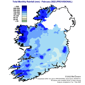
Titim Báistí: Os cionn an mheáin i mbeagnach gach áit; ba é an tIarthuaisceart an ceantar ba fhliche
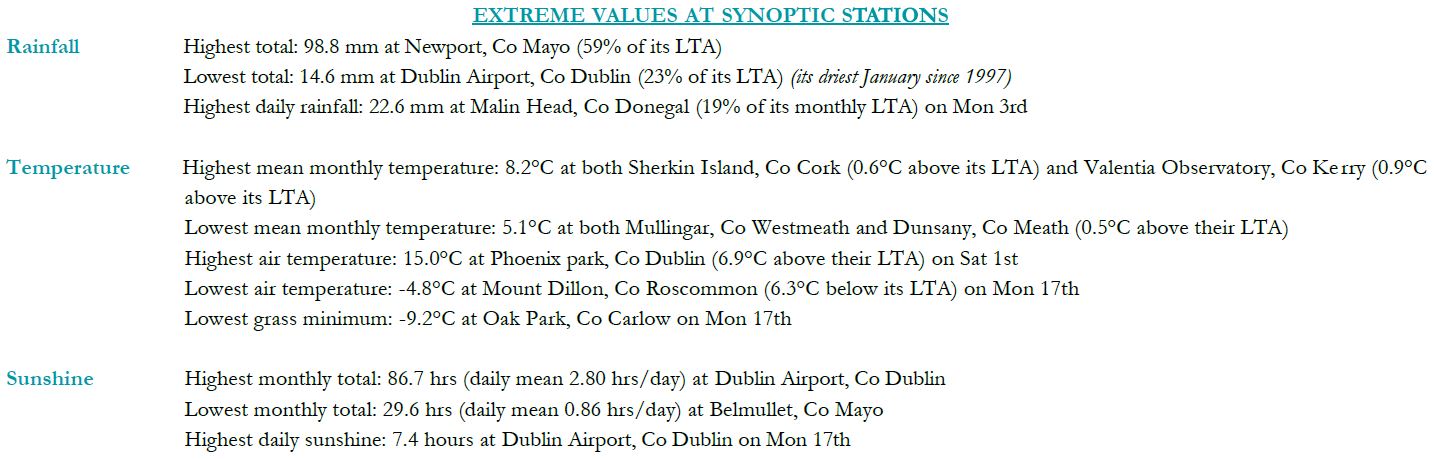
Bhí na hiomláin bháistí go léir beagnach os cionn a Meánleibhéil Fhadtéarmaigh (MLFT) don mhí. Bhí céatadán na luachanna titime báistí míosúla idir 100% (iomlán titime báistí míosúla de 101.4 mm) ag Inis Arcáin, Co. Chorcaí agus 206% ag Aeradróm Mhic Easmainn, Co. Bhaile Átha Cliath (iomlán titime báistí míosúla de 99.9 mm) agus ag Baile Uí Fhiacháin, Co. Mhaigh Eo (an t-iomlán míosúil is airde ná 260.4 mm). Bhí na hiomláin titime báistí míosúla is ísle ag Baile an Phaghanaigh, Co. Cheatharlach .i. 82.5 mm (144% dá MLFT). Chomh maith leis sin, taifeadadh an lá is fliche i rith na míosa ag Baile Uí Fhiacháin, Co. Mhaigh Eo – thit 32.3 mm de bháisteach ar an Satharn, an 19ú lá. Bhí líon na laethanta báistí idir 21 lá ag Caisleán Bhaile Sheáin, Co. Loch Garman agus 28 lá ag roinnt stáisiún. Bhí líon na laethanta fliucha1 idir 14 lá i gCaisleán Bhaile Sheáin, Co. Loch Garman go 26 lá i mBéal an Mhuirthead, Co. Mhaigh Eo. Bhí líon na laethanta an-fhliuch3 idir 1 lá ag an gCloch Liath, Co. Chorcaí agus 10 Lá ag Baile Uí Fhiacháin, Co. Mhaigh Eo.
Teocht: Os cionn an mheáin i ngach áit
Bhí meánteocht an aeir ar fud na tíre os cionn an Mheánleibhéil Fhadtéarmaigh (MLFT) don mhí seo. Bhí athruithe ó mheánteocht an aeir idir 0.9 °C (meánteocht 6.4 °C) ag Marcréidh, Co. Shligigh agus 1.8 °C (7.1 °C meánteocht) ag Páirc an Fhionnuisce, Co. Bhaile Átha Cliath. Bhí meánteochtaí don mhí idir 5.5 °C (1.3 °C os cionn a MLFT) ag Aerfort Chnoc Mhuire, Co. Mhaigh Eo agus 8.8 °C (1.3 °C os cionn a MLFT) ag Inis Arcáin, Co. Chorcaí. Tuairiscíodh an teocht is airde an mhí seo ag gCloch Liath, Co. Chorcaí ar an gCéadaoin, an 16ú lá, lá ar a raibh an teocht cothrom le 15.3 °C (an uasteocht is airde i mí Feabhra ó 2012). Taifeadadh an íosteocht aeir agus féir is ísle i rith na míosa Dé hAoine, an 11ú lá, ar an Muileann gCearr, Co. na hIarmhí. Bhí an t-íosmhéid aeir ab ísle cothrom le -2.6 °C agus bhí an t-íosmhéid féir ab ísle cothrom le -8.4 °C. Thuairiscigh níos mó ná leath na stáisiún sioc talún. Bhí líon na laethanta inar taifeadadh sioc talún idir lá ar bith i mBéal an Mhuirthead, Co. Mhaigh Eo agus 16 lá ag Cluain Creamha, Co. Ros Comáin. Thuairiscigh níos mó ná leath na stáisiún sioc aeir. Bhí líon na laethanta inar taifeadadh sioc aeir idir lá ar bith ag Ceann Mhása, Co. na Gaillimhe agus 5 lá ag An Chloch Liath, Co. Chorcaí agus An Muileann gCearr, Co. na hIarmhí.
Taitneamh na Gréine: Grianmhar sa Deisceart, gruama i ngach áit eile
Bhí céatadán luachanna an Mheánleibhéil Fhadtéarmaigh (MLFT) do luachanna thaitneamh na gréine athraitheach ar fud na tíre. Bhí céatadán luachanna míosúla thaitneamh na gréine idir 94% (taitneamh gréine míosúil iomlán de 66.6 uair an chloig) ag Aeradróm Mhic Easmainn, Co. Bhaile Átha Cliath agus 109% (taitneamh gréine míosúil iomlán de 71.4 uair an chloig) ag Aerfort na Sionainne, Co. an Chláir. Bhí na hiomláin mhíosúla thaitneamh na gréine is airde ag Caisleán Bhaile Sheáin, Co. Loch Garman – 86.2 uair an chloig (níl comparáid MLFT ar fáil*). Bhí na hiomláin mhíosúla thaitneamh na gréine is ísle ag Cionn Mhálanna, Co. Dhún na nGall – 45.5 uair an chloig (níl comparáid MLFT ar fáil*). Ba é 8.5 uair an chloig ag Caisleán Bhaile Sheáin, Co. Loch Garman, Dé hAoine, an 25ú lá, an líon is airde uaireanta an chloig de thaitneamh gréine laethúla a taifeadadh an mhí seo. Bhí líon na laethanta gruama2 idir 5 lá ag Aerfort Chorcaí agus 12 lá ag Béal an Mhuirthead, Co. Mhaigh Eo.
Gaoth: Gaotha fórsa stoirme tréana tuairiscithe i rith Stoirm Eunice
Bhí meánluas míosúil na gaoithe idir 8.7 muirmhíle san uair (16.1 km/u) ag an gCloch Liath, Co. Chorcaí agus 22.6 muirmhíle san uair (41.9 km/u) ag Ceann Mhása, Co. na Gaillimhe. Tuairiscíodh gálaí ar roinnt laethanta agus tuairiscíodh gálaí láidre ar an 6ú, 16ú, 17ú, 18ú, 20ú, 21ú agus 24ú lá. Tuairiscíodh gaotha fórsa stoirme Dé Domhnaigh, an 20ú lá, agus Dé Luain, an 21ú lá, i rith stoirm Franklin. Tuairiscíodh gaotha fórsa stoirme tréana Dé hAoine, an 18ú lá, i rith stoirm Eunice. Bhí líon na laethanta le gálaí idir lá ar bith ag cúpla stáisiún go 15 lá i gCeann Mhása, Co na Gaillimhe. Bhí líon na laethanta le gálaí láidre idir lá ar bith ag cúpla stáisiún agus 6 lá ag Ceann Mhása, Co. na Gaillimhe. Bhí líon na laethanta le gaotha fórsa stoirme idir lá ar bith ag formhór na stáisiún agus dhá lá ag Cionn Mhálanna, Co. Dhún na nGall agus ag Ceann Mhása, Co. na Gaillimhe. Bhí gaotha fórsa stoirme tréana le tabhairt faoi deara lá amháin ag Rinn an Róistigh, Co. Chorcaí i rith Stoirm Eunice. Tuairiscíodh an séideán is airde i rith na míosa ag Ceann Mhása, Co. na Gaillimhe, ar an 20ú Feabhra, séideán a bhí cothrom le 75 muirmhíle (138 km/u). Bhí meánluas gaoithe 10 nóiméad is airde na míosa cothrom le 57 muirmhíle (105 km/u) ag Rinn an Róistigh, Co. Chorcaí ar an 18ú lá.
Luachanna foircneacha do mhí Feabhra ag stáisiúin shionoptacha
Tá an tuairisc iomlán ar fáil anseo
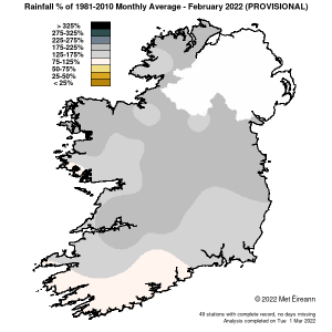
% titim báistí 1981 – 2021 Meán Míosúil do mhí Feabhra 2022 (Sealadach)
Titim Báistí Mhíosúil Iomlán (mm) do mhí Feabhra 2022 (Sealadach)