As Saint Patrick’s Day falls in early spring, this time of the year can bring a variety of weather types to Ireland. High- and low-pressure systems located around Ireland can lead to cold arctic air masses moving down from the north, or warm tropical air masses moving up from the south. Sunshine becoming brighter and stronger in spring can result in warmer temperatures, but can also spark convective shower activity in the later hours of the day.
Cold, wintry conditions are common around St. Patrick’s Day in Ireland.
In 1979, an Arctic air mass brought north-easterly winds with widespread snow showers. Snow was recorded in many counties including Dublin, Wicklow, Kilkenny, Cork, Tipperary, Offaly, and Louth, where, as a result of this snowfall, the Drogheda St. Patrick’s Day parade was cancelled.
With data extending as far back as 1940, –8 °C is the lowest temperature recorded in Ireland on March 17th, 1989, in Collooney, Co. Sligo, where a frosty start to the day was followed by bright and dry conditions across the country.
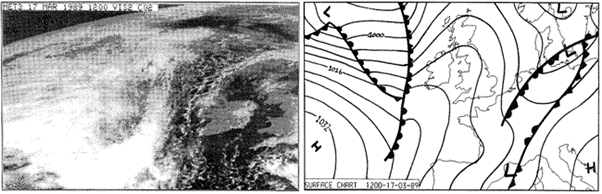
Ireland basks in sunshine on 17th March 1989 after a frosty start. See close to the west are the rain fronts which moved in dominated over the weekend.
Warm weather can also be a common feature on St. Patrick’s Day in Ireland.
In 2005, originating in the south, a very mild tropical maritime air mass moved over the country between the 16th and 20th of March. During this warm period, a temperature of 19.6 °C was recorded in Ashford (Cronykeery), Co Wicklow on St. Patrick’s Day. This is still the record highest temperature recorded on March 17th since 1940.
Unusual weather extremes have also been reported on St. Patrick’s Day in the past.
On March 17th 1995, a tornado was reported in County Meath. Ireland lay in a very unstable and cold north-westerly airflow associated with a deep depression to the north of Scotland. This brought heavy wintry showers, with thunderstorms reported at both Mullingar and Shannon Airport before midday. Thunderstorms were widely reported throughout the afternoon as a showery trough moved across the country. The tornado was reportedly between 14:10 and 14:30 UTC, moving quickly eastwards in a strong westerly flow over a path approximately 28 kilometres long. It was accompanied by lightning and hailstones of up to 5cm in diameter. The tornado caused considerable structural damage to dwellings and farm buildings. The noise from the approaching tornado was described similar to “the roar of a low-flying aircraft”.
The full report on this event can be found here.
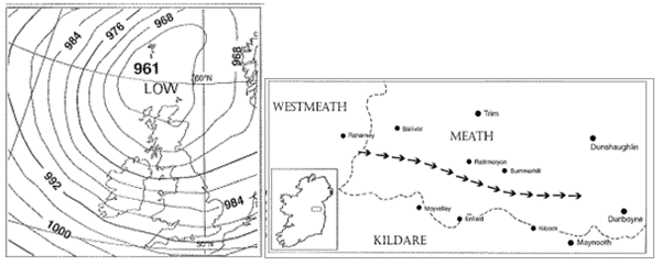
Figs 1-2 : 1) Position of the low which brought a tornado to Summerhill, Co Meath on March 17th 1995; 2) The arrows mark the path taken by the tornado through Co Meath.
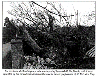
Fig. 3 – Some damage provoked by the tornado on March 17th 1995. Image copied from this report in our Major Weather Events page
Although there have been no named storms in recent years occurring on St. Patrick’s Day, it can often be very windy. The highest winds recorded on St. Patrick’s Day since 1940 were reported in 1968 at Malin Head, Co Donegal. The highest gust was 154 km/h while highest 10-minute mean wind speed was 89 km/h.
The highest rainfall recorded on St. Patrick’s Day since 1940 was 80.7 mm in Glenvickee (Caragh River Area), Co Kerry in 1964, while the record for sunshine was 10.6 hours, reported at Dublin Airport in 1985.
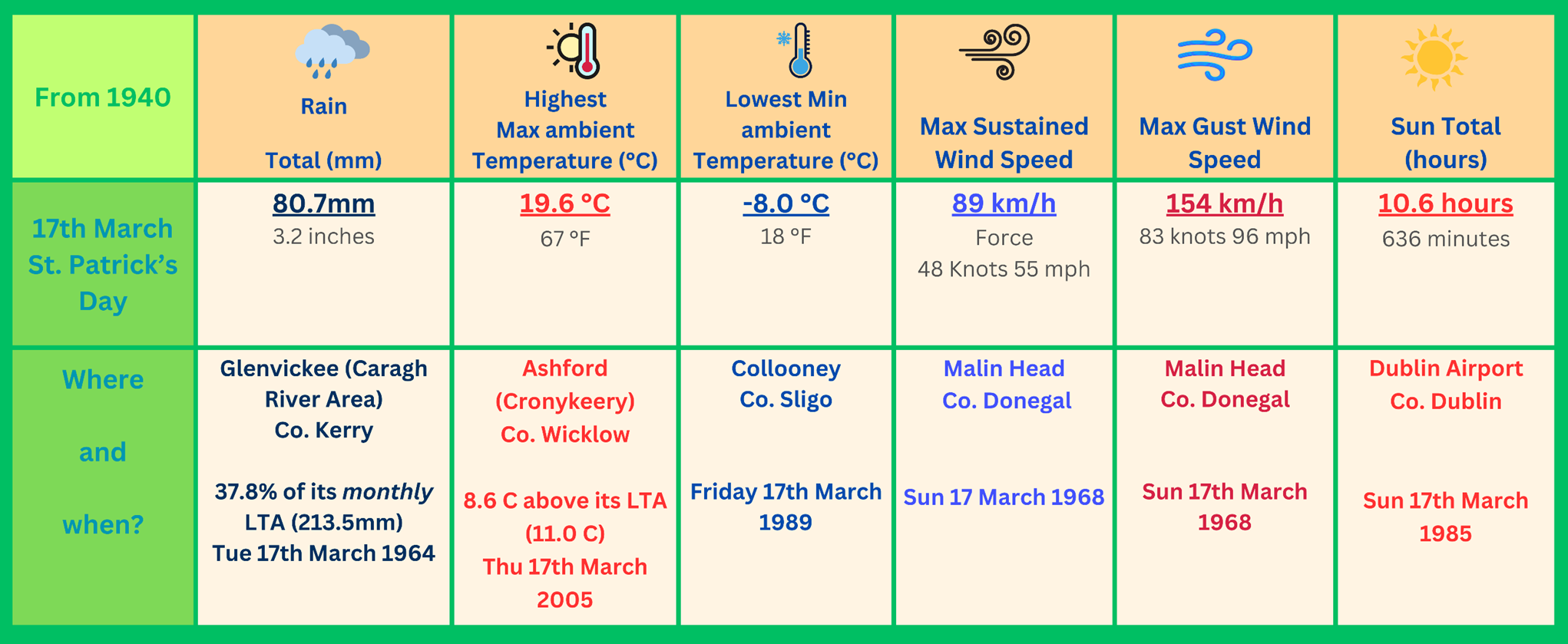
Fig 3 – Extreme values recorded on Saint Patrick’s day in Ireland, since 1940
Last year St Patrick’s day’s weather didn’t break any records, it was mostly cloudy with rain and drizzle in the south and west extending northeastwards to all areas. Some dry intervals developed in the afternoon, with moderate breezes. What will this year bring? As of Friday 15th March, the outlook is for a damp and cloudy morning to begin, with sunny spells and scattered showers developing for the rest of the day, some heavy ones possible. Temperature-wise, a mild day with highs of 12-15 °C with light to moderate southwest breezes. On Sunday night we can expect clear spells and outbreaks of showery rain moving eastwards overnight, with some heavy falls possible. Lowest temperatures of 5-8 °C with light to moderate southerly breezes.
Keep up to date with the forecast on met.ie and the Met Éireann App, and….