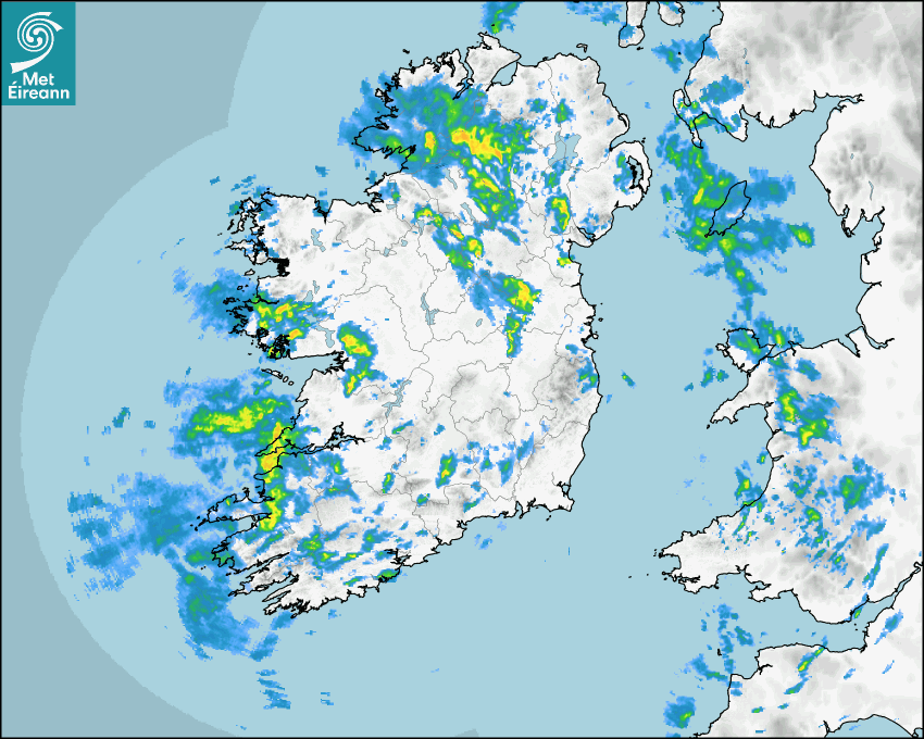

Latest Rainfall Radar showing live precipitation and the last 90 minutes precipitation over Ireland, updated every 5 minutes. Precipitation can be rain, hail or snow. Accumulations can refer to rainfall only.
Lightning strikes, when they occur, are displayed as a cross. Initially, they are red but change to orange and then yellow after a period, then disappear © Met Office ATDNet.
Ground Clutter may appear (South Co. Dublin), bright bands and spokes may also be present in images. They are artefacts (false echoes) of rainfall radar systems and should be ignored. Further information on Radar here
Met Éireann forecasters manually produce the weather icons for midday and midnight to reflect the predicted major weather type for these times.
The rainfall forecast is direct model output from Numerical Weather Prediction models but is a guideline only. Rain refers to precipitation, which can be rain, sleet or snow. It forecasts how much rain will fall (in mm) hourly during the previous hour (accumulations), then in 3 hourly and finally 6 hourly accumulations up to 7 days. This service is based on data and products of the HARMONIE-AROME and the European Centre for Medium-range Weather Forecasts (ECMWF) models.
The wind is direct model output from Numerical Weather Prediction models but is a guideline only. It forecasts the strength of the wind (in knots and km/h) at 10m for the top of each hour, in hourly, then 3 hourly and finally 6 hourly intervals up to 7 days. The wind arrow tip points in the direction the wind is blowing and the tail length indicates wind strength. However, in the text forecast below, it is described as where it is blowing from. This service is based on data and products of the HARMONIE-AROME and the European Centre for Medium-range Weather Forecasts (ECMWF) models.
The temperature is direct model output from Numerical Weather Prediction models but is a guideline only. It forecasts air temperature on land and over sea in °C for the top of each hour, 3 hourly and finally 6 hourly intervals up to 7 days. Minus zero (-0) indicates values between 0 to -0.5°C. This service is based on data and products of the HARMONIE-AROME and the European Centre for Medium-range Weather Forecasts (ECMWF) models.
The Mean Sea Level Pressure (MSLP) is direct model output from Numerical Weather Prediction models but is a guideline only. It forecasts the MSLP in hecto Pascals (hPa) for the top of that hour initially in 3 hourly intervals, then 6 hourly. This service is based on data and products of the HARMONIE-AROME and the European Centre for Medium-range Weather Forecasts (ECMWF) models.
National Forecast
19 May 2026 08:00
Today
Generally cloudy today with widespread showers or more persistent spells of rain, some of which will be heavy with the possibility of isolated thunderstorms or hail. The showers will ease from the west through the evening. Highest temperatures of 12 to 17 degrees, warmest in the northeast, with moderate to fresh southwesterly winds, stronger near southern and southwestern coasts.
Tonight
Remaining cloudy overnight with showers or longer spells of rain and drizzle continuing. Lowest temperatures of 8 to 11 degrees, with mostly light to moderate, occasionally fresh, southwesterly winds, veering westerly towards morning.
Tomorrow
Plenty of dry weather with just a few light showers around at first. The best of the sunny spells will be over the northern half of the country as cloud gradually increases from the southwest through the day. Some rain and drizzle will follow into the southwest in the evening. Highest temperatures of around 13 to 18 degrees, with light to moderate, occasionally fresh, southwesterly breezes.
Met News

07th May 2026
Met Éireann to take pride of place at Bord Bia Bloom as part of 90th celebrations
Preparations are ramping up for Ireland’s premie... more

05th May 2026
Climate Statement for April 2026
Mild and quite sunny overall. Wet in the West, dry... more

29th April 2026
Europe continues as fastest-warming region, says State of the Climate 2025 report
Europe is warming twice as fast as the global aver... more

09th April 2026
2026 Nematodirus Forecast
From Department of Agriculture, Food and the Marin... more