Mild and quite sunny overall. Wet in the West, dry in the East
April 2026 was mild and quite sunny overall, wet in the West and dry in the East. The majority of the month was dominated by Atlantic low pressure, with deep low pressure systems bringing wind and rain, including Storm Dave on 4th April. Further low pressure systems brought more rain, mostly to the West of the country. A high pressure system then moved over the country, with drier and sunnier conditions from 18th April onwards. For April 2026, all stations recorded temperatures above their 1991-2020 Long-Term Average (LTA) with a national mean April temperature of 9.69 °C. The month ended unsettled with pulses of rain moving up from the South
Key figures:
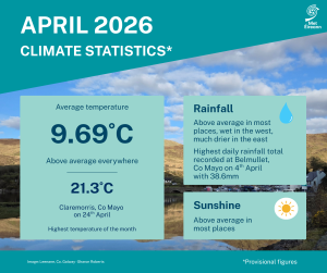
- The national mean April temperature was 9.69 °C, making it the 12th warmest April since 1900.
- 9.69 °C is 1.59 °C above the 1961-1990 LTA and 0.81 °C above the 1991-2020 LTA.
- The month’s highest temperature was reported at Claremorris, Co May on Friday 24th with a temperature of 21.3 °C.
- April 2026 was wetter than normal with 113 % of the 1991-2020 LTA (92.7 mm) and is ranked 21st wettest April since 1941.
- The highest daily rainfall total was 38.6 mm at Belmullet, Co Mayo on Saturday 4th.
April Climate Statement highlights.
Atlantic low pressure dominated the first two thirds of April 2026 before high pressure to the north took control for the final third. The first two thirds of the month saw a series of unseasonably deep low pressure systems traversing a path in the North Atlantic, from southwest to northeast, passing close to the northwest of Ireland. One such system Storm Dave, named by the UK Met Office, was deepening rapidly as the centre passed over the northwest of Ireland late on Saturday 4th and brought a spell of wet and windy weather. Several more low pressure systems passed close to the northwest of Ireland, up to Friday 17th, bringing further spells of wet and windy weather, interspersed with showers. The bulk of the rain fell over the western half of the country, closest to the low pressure systems. The east of the country, although windy at times, saw much less rainfall during this period owing to the influence of higher pressure to the east over mainland Europe.
High pressure built over the country on Saturday 18th and moved to the north of Ireland over the following few days, where it stalled for the rest of the month. This brought much drier and sunnier conditions in a mostly easterly airflow, and it gradually warmed up, especially in the west. The month finished with pulses of heavy rain moving up from the south affecting the Midlands, South and West, bringing an end to the settled spell.
Rainfall: Wet in the West, dry in the East
The majority of monthly rainfall totals were above their 1991-2020 Long-Term Average (LTA). Percentage of monthly rainfall values ranged from 37% (20.2 mm) at Casement Aerodrome, Co Dublin (its driest April since 2021) to 166% (123.1 mm) at Belmullet, Co Mayo (its wettest April since 1991). Monthly rainfall totals ranged from 20.2 mm (37% of its LTA) at Casement Aerodrome, Co Dublin to 151.1 mm (139% of its LTA) at Valentia Observatory, Co Kerry (its wettest April since 2018). The highest daily rainfall total was 38.6 mm at Belmullet, Co Mayo on Saturday 4th (its highest daily fall for April on record (length 69 years)).
The number of rain days* ranged from 13 days at a few stations to 21 days at Belmullet, Co Mayo. The number of wet days* ranged from 8 days at a few stations to 19 days at Belmullet, Co Mayo. The number of very wet days* ranged from zero days at a few stations to 6 days at Valentia Observatory, Co Kerry. Mace Head, Co Galway had its wettest April on record with 109.8 mm (165% of its LTA) (length 20 years). Two stations in the East, Phoenix Park and Casement Aerodrome, Co Dublin, had dry spells* lasting 15 days (ongoing) between Thursday 16th and Thursday 30th.
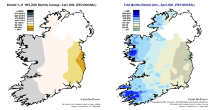
Rainfall % of 1991 – 2020 Monthly Average for April 2026 (Provisional). Total Monthly Rainfall (mm) for April 2026 (Provisional).
Temperature: Above average everywhere, warmest in the West
All mean air temperatures across the country were above their LTA for the month. Deviations from mean air temperature ranged from +0.2 °C (8.5 °C mean temperature) at Ballyhaise, Co Cavan to 1.1 °C at Moore Park, Co Cork and Johnstown Castle, Co Wexford (9.7 °C and 9.8 °C mean temperature respectively). Mean temperatures for the month ranged from 8.5 °C at both Ballyhaise, Co Cavan and Knock Airport, Co Mayo (0.8°C above its LTA) to 10.4 °C at Valentia Observatory, Co Kerry (0.9 °C above its LTA). The month’s highest temperature was reported at Claremorris, Co Mayo on Friday 24th with a temperature of 21.3 °C. The month’s lowest air minimum was recorded on Monday 13th at Mount Dillon, Co Roscommon with -1.8 °C while the lowest grass minimum was -6.0 °C reported at Casement Aerodrome, Co Dublin on Monday 20th. More than half of stations reported ground frost. The number of days with ground frost ranged from zero days at both Mace Head, Co Galway and Cork Airport to 19 days at Phoenix Park, Co Dublin. Less than half of stations reported air frost. The number of days with air frost ranged from zero days at thirteen stations to 4 days at both Markree, Co Sligo and Mount Dillon, Co Roscommon.
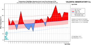
Valentia Observatory, Co Kerry. Temperature: Daily mean departure from LTA for April 2026 based on 09-09hr Max/Min values.

Ballyhaise, Co Cavan. Temperature: Daily mean departure from LTA for April 2026 based on 09-09hr Max/Min values.
Sunshine: Above average generally, sunniest in the Southeast
Nearly all available sunshine totals were above their LTA. Percentage of monthly sunshine values ranged from 114% (186.5 hours) at Shannon Airport, Co Clare to 128% (201.5 hours) at Casement Aerodrome, Co Dublin. Monthly sunshine totals ranged from 138.6 hours (No LTA comparison*) at Valentia Observatory, Co Kerry to 209.1 hours (No LTA comparison*) at Johnstown Castle, Co Wexford. The highest number of daily sunshine hours recorded this month was 14.2 hours at Malin Head, Co Donegal on Wednesday 29th. The number of dull days* ranged from 2 days at both Dublin Airport and Casement Aerodrome, Co Dublin to 7 days at Cork Airport, Co Cork.
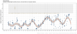
Hours of Bright Sunshine observed at nine stations for each day of the month of April 2026, grouped by province relative to the highest number of hours possible by end of month (shaded box).
Wind: Storm Force winds reported at one station during storm Dave
Monthly mean wind speeds ranged from 6.8 knots (12.6 km/h) at Mount Dillon, Co Roscommon to 15.4 knots (28.5 km/h) at Mace Head, Co Galway. Gales were reported on the 4th, 5th, 9th, 10th, 11th 12th and 15th with strong gales reported at three stations on Saturday 4th during storm Dave and at two stations on Saturday 11th. Mean wind speeds reached storm force on Saturday 4th during storm Dave at one station, Roches Point, Co Cork. The number of days with gales ranged from zero days at a few stations to 6 days at Mace Head, Co Galway. The number of days with up to strong gales ranged from zero at most stations to 2 days at Roches Point, Co Cork. The number of days with storms force winds was 1 day at Roches Point, Co Cork. The month’s highest gust was reported at both Roches Point, Co Cork and Valentia Observatory, Co Kerry both on Saturday 4th during storm Dave with 60 knots (111 km/h). The highest 10-minute wind speed was 48 knots (89 km/h) reported at Roches Point, Co Cork on Saturday 4th. Sherkin Island, Co Cork had its highest monthly mean wind speed for April on record with 15.5 knots (28 km/h) (length 20 years). Eight stations had their highest monthly mean wind speed for April since 2013 and one station had its highest since 2012. Three stations, Ballyhaise, Co Cavan, Gurteen, Co Tipperary and Athenry, Co Galway, had their highest April gust on record on Saturday 4th during storm Dave (record lengths between 16 and 20 years).
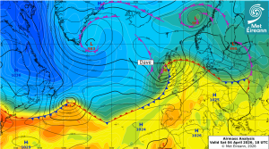
Airmass Analysis chart 18 UTC 04 April 2026: Storm Dave moved northwest over the north of Ireland towards Scotland.
Full PDF report and charts are available here
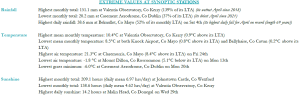
Extreme values for April 2026 at synoptic stations.
Notes to Editor:
- *Issued by Met Éireann on Tuesday 5th May 2026. This report is based on available preliminary data from 25 principal weather stations operated by Met Éireann. Synoptic station data is midnight to midnight UTC. Long-Term Averages (LTAs) and “average” refer to the period 1991-2020 unless stated.
- A rain day is a day on which 0.2 mm or more of rainfall is measured. A wet day is a day with 1.0 mm or more of rainfall. A dull day is a day with less than 0.5 hours of sunshine. A very wet day is a day with 10.0 mm or more of rainfall.
- Climatological dry periods – An absolute drought is a period of 15 or more consecutive days to none of which is credited 0.2 mm or more of precipitation. A partial drought is a period of at least 29 consecutive days, the mean daily rainfall of which does not exceed 0.2 mm. A dry spell is a period of 15 or more consecutive days to none of which is credited 1.0 mm or more of precipitation (i.e. daily tot < 1.0 mm).
- A heatwave occurs where there are 5 consecutive days or more with maximum temperature over 25°C (that is, a daily maximum screen air temperature > 25° C).
- The ‘Island of Ireland’ dataset is 125 years long and runs between 1900 and 2023. For this dataset the long term averages from the 1961-1990 reference period are used for comparison as is standard for long-term climate change assessments.
- Sunshine data is from the Autosol Network. LTAs for these sites are currently not used for comparison purposes.
- For more information or interview opportunities with a Met Éireann spokesperson, please contact us at enq@met.ie.