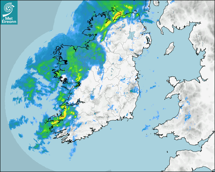

Latest Rainfall Radar showing live precipitation and the last 90 minutes precipitation over Ireland, updated every 5 minutes. Precipitation can be rain, hail or snow. Accumulations can refer to rainfall only.
Lightning strikes, when they occur, are displayed as a cross. Initially, they are red but change to orange and then yellow after a period, then disappear © Met Office ATDNet.
Ground Clutter may appear (South Co. Dublin), bright bands and spokes may also be present in images. They are artefacts (false echoes) of rainfall radar systems and should be ignored. Further information on Radar here
Met Éireann forecasters manually produce the weather icons for midday and midnight to reflect the predicted major weather type for these times.
The rainfall forecast is direct model output from Numerical Weather Prediction models but is a guideline only. Rain refers to precipitation, which can be rain, sleet or snow. It forecasts how much rain will fall (in mm) hourly during the previous hour (accumulations), then in 3 hourly and finally 6 hourly accumulations up to 7 days. This service is based on data and products of the HARMONIE-AROME and the European Centre for Medium-range Weather Forecasts (ECMWF) models.
The wind is direct model output from Numerical Weather Prediction models but is a guideline only. It forecasts the strength of the wind (in knots and km/h) at 10m for the top of each hour, in hourly, then 3 hourly and finally 6 hourly intervals up to 7 days. The wind arrow tip points in the direction the wind is blowing and the tail length indicates wind strength. However, in the text forecast below, it is described as where it is blowing from. This service is based on data and products of the HARMONIE-AROME and the European Centre for Medium-range Weather Forecasts (ECMWF) models.
The temperature is direct model output from Numerical Weather Prediction models but is a guideline only. It forecasts air temperature on land and over sea in °C for the top of each hour, 3 hourly and finally 6 hourly intervals up to 7 days. Minus zero (-0) indicates values between 0 to -0.5°C. This service is based on data and products of the HARMONIE-AROME and the European Centre for Medium-range Weather Forecasts (ECMWF) models.
The Mean Sea Level Pressure (MSLP) is direct model output from Numerical Weather Prediction models but is a guideline only. It forecasts the MSLP in hecto Pascals (hPa) for the top of that hour initially in 3 hourly intervals, then 6 hourly. This service is based on data and products of the HARMONIE-AROME and the European Centre for Medium-range Weather Forecasts (ECMWF) models.
National Forecast
04 April 2026 12:00
Today
Storm Dave will track near our west and north coast this afternoon and evening, bringing very windy and wet weather. Southerly winds, veering westerly will strengthen to very strong and gusty throughout the day, particularly in parts of Munster and Leinster with some damaging gusts. Strong onshore winds, coinciding with high tide will increase the risk of wave overtopping and coastal flooding. Rain will be heavy and persistent in the north and north-west at first. Over high ground in Ulster, there is a possibility that precipitation may fall as sleet. Drier elsewhere for a time before persistent and heavy rain spreads eastwards across the country through the afternoon, with spot flooding possible. A clearance to scattered showers follow from to the west later. Highest temperatures of 9 to 12 degrees.
Tonight
Winds abating with clear spells and scattered showers, with the chance of hail or sleet on higher ground. Chilly overnight with lowest temperatures of 0 to 4 degrees in moderate to fresh southwest winds, gradually veering westerly and easing overnight, but staying strong along Atlantic coasts.
Tomorrow
Bright and breezy with scattered showers and sunny spells. Some showers may fall as sleet or hail on higher ground early on. The showers will become more isolated through the afternoon. Feeling crisp with highest temperatures of just 7 to 10 degrees in moderate to fresh westerly winds.
Met News

02nd April 2026
Climate Statement for March 2026
Mild and sunny. Wet for most, drier in the South M... more

23rd March 2026
World Meteorological Day, 2026 - Observing Today, Protecting Tomorrow
State of the Global Climate report issued today as... more

04th March 2026
Climate Statement for Winter 2025/2026
Mild December and February, cool January. Wet in t... more