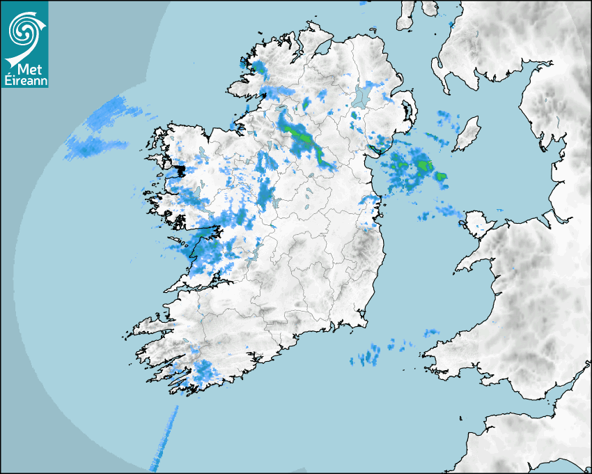

Latest Rainfall Radar showing live precipitation and the last 90 minutes precipitation over Ireland, updated every 5 minutes. Precipitation can be rain, hail or snow. Accumulations can refer to rainfall only.
Lightning strikes, when they occur, are displayed as a cross. Initially, they are red but change to orange and then yellow after a period, then disappear © Met Office ATDNet.
Ground Clutter may appear (South Co. Dublin), bright bands and spokes may also be present in images. They are artefacts (false echoes) of rainfall radar systems and should be ignored. Further information on Radar here
Met Éireann forecasters manually produce the weather icons for midday and midnight to reflect the predicted major weather type for these times.
The rainfall forecast is direct model output from Numerical Weather Prediction models but is a guideline only. Rain refers to precipitation, which can be rain, sleet or snow. It forecasts how much rain will fall (in mm) hourly during the previous hour (accumulations), then in 3 hourly and finally 6 hourly accumulations up to 7 days. This service is based on data and products of the HARMONIE-AROME and the European Centre for Medium-range Weather Forecasts (ECMWF) models.
The wind is direct model output from Numerical Weather Prediction models but is a guideline only. It forecasts the strength of the wind (in knots and km/h) at 10m for the top of each hour, in hourly, then 3 hourly and finally 6 hourly intervals up to 7 days. The wind arrow tip points in the direction the wind is blowing and the tail length indicates wind strength. However, in the text forecast below, it is described as where it is blowing from. This service is based on data and products of the HARMONIE-AROME and the European Centre for Medium-range Weather Forecasts (ECMWF) models.
The temperature is direct model output from Numerical Weather Prediction models but is a guideline only. It forecasts air temperature on land and over sea in °C for the top of each hour, 3 hourly and finally 6 hourly intervals up to 7 days. Minus zero (-0) indicates values between 0 to -0.5°C. This service is based on data and products of the HARMONIE-AROME and the European Centre for Medium-range Weather Forecasts (ECMWF) models.
The Mean Sea Level Pressure (MSLP) is direct model output from Numerical Weather Prediction models but is a guideline only. It forecasts the MSLP in hecto Pascals (hPa) for the top of that hour initially in 3 hourly intervals, then 6 hourly. This service is based on data and products of the HARMONIE-AROME and the European Centre for Medium-range Weather Forecasts (ECMWF) models.
National Forecast
27 June 2025 04:58
Today
Mostly cloudy and rather breezy today with scattered outbreaks of rain and drizzle. The rain will be most persistent across the west and northwest of the country with long dry spells elsewhere. The best chance for some bright or sunny spells will be across east Leinster in the afternoon. A humid day with highest temperatures of 17 to 22 degrees in fresh and gusty southwest winds, warmest in the east.
Tonight
It will stay humid and breezy overnight with patchy rain and drizzle. Later in the night, heavier and more persistent rain will develop in Connacht. A close and humid night with lowest temperatures of 14 to 18 degrees in moderate to fresh southwest winds.
Tomorrow
Saturday will start out mostly cloudy with scattered falls of rain and drizzle. It looks set to become drier and brighter across the northern half of the country during the afternoon and evening with sunny spells. However, cloud and patchy rain will linger in many southern areas throughout much of the day. Maximum temperatures ranging from 17 to 23 degrees in moderate southwest winds.
Met News


05th June 2025
Climate Statement for Spring 2025
Ireland records highest average temperature and ho... more

04th June 2025
Climate Statement for May 2025
Warm, dry, calm and very sunny May for Ireland I... more

23rd May 2025
Marine Heatwave off Ireland’s Coast in May 2025
High pressure and easterly winds are contributing ... more