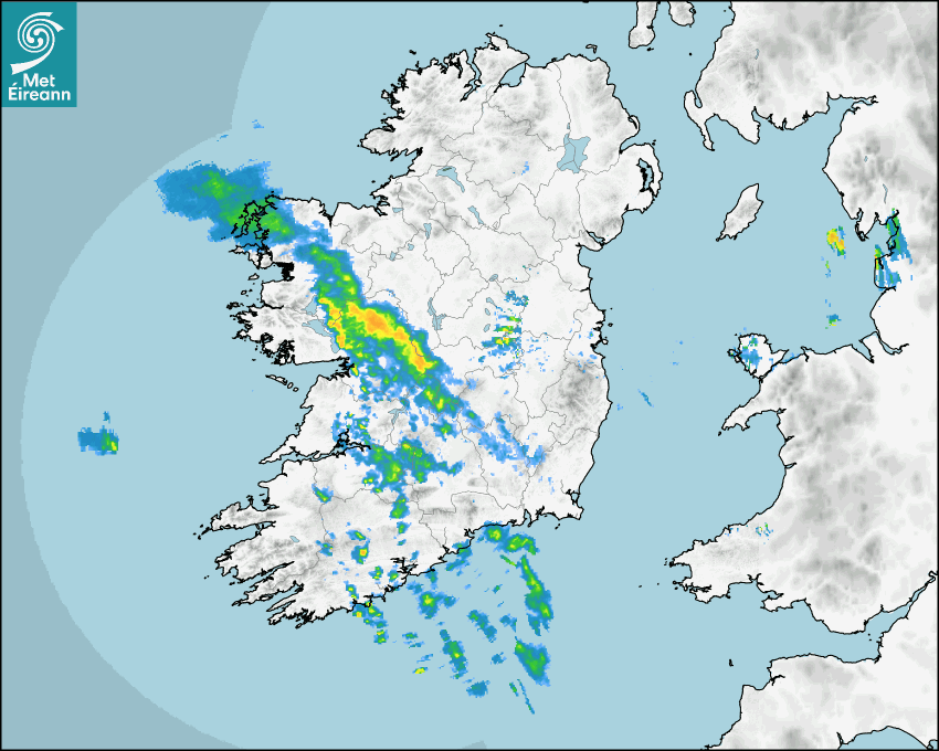

Latest Rainfall Radar showing live precipitation and the last 90 minutes precipitation over Ireland, updated every 5 minutes. Precipitation can be rain, hail or snow. Accumulations can refer to rainfall only.
Lightning strikes, when they occur, are displayed as a cross. Initially, they are red but change to orange and then yellow after a period, then disappear © Met Office ATDNet.
Ground Clutter may appear (South Co. Dublin), bright bands and spokes may also be present in images. They are artefacts (false echoes) of rainfall radar systems and should be ignored. Further information on Radar here
Met Éireann forecasters manually produce the weather icons for midday and midnight to reflect the predicted major weather type for these times.
The rainfall forecast is direct model output from Numerical Weather Prediction models but is a guideline only. Rain refers to precipitation, which can be rain, sleet or snow. It forecasts how much rain will fall (in mm) hourly during the previous hour (accumulations), then in 3 hourly and finally 6 hourly accumulations up to 7 days. This service is based on data and products of the HARMONIE-AROME and the European Centre for Medium-range Weather Forecasts (ECMWF) models.
The wind is direct model output from Numerical Weather Prediction models but is a guideline only. It forecasts the strength of the wind (in knots and km/h) at 10m for the top of each hour, in hourly, then 3 hourly and finally 6 hourly intervals up to 7 days. The wind arrow tip points in the direction the wind is blowing and the tail length indicates wind strength. However, in the text forecast below, it is described as where it is blowing from. This service is based on data and products of the HARMONIE-AROME and the European Centre for Medium-range Weather Forecasts (ECMWF) models.
The temperature is direct model output from Numerical Weather Prediction models but is a guideline only. It forecasts air temperature on land and over sea in °C for the top of each hour, 3 hourly and finally 6 hourly intervals up to 7 days. Minus zero (-0) indicates values between 0 to -0.5°C. This service is based on data and products of the HARMONIE-AROME and the European Centre for Medium-range Weather Forecasts (ECMWF) models.
The Mean Sea Level Pressure (MSLP) is direct model output from Numerical Weather Prediction models but is a guideline only. It forecasts the MSLP in hecto Pascals (hPa) for the top of that hour initially in 3 hourly intervals, then 6 hourly. This service is based on data and products of the HARMONIE-AROME and the European Centre for Medium-range Weather Forecasts (ECMWF) models.
National Forecast
24 April 2026 21:00
Tonight
Generally dry and clear tonight with just a touch of cloud across southern counties and winds remaining light. Isolated showers will drift over parts of Munster and Connacht later. Cold under clear skies with lows of 1 to 4 degrees in parts of Ulster and north Leinster. Milder elsewhere with lows of 6 to 10 degrees.
Tomorrow
A mostly dry day with just a few isolated showers possible. Cloudier than recent days, with the best of the sunshine over the eastern half of the country. Highest temperatures of 13 degrees in the west to 20 degrees in the east, with light variable breezes.
Met News

09th April 2026
2026 Nematodirus Forecast
From Department of Agriculture, Food and the Marin... more

02nd April 2026
Climate Statement for March 2026
Mild and sunny. Wet for most, drier in the South M... more

23rd March 2026
World Meteorological Day, 2026 - Observing Today, Protecting Tomorrow
State of the Global Climate report issued today as... more

04th March 2026
Climate Statement for Winter 2025/2026
Mild December and February, cool January. Wet in t... more