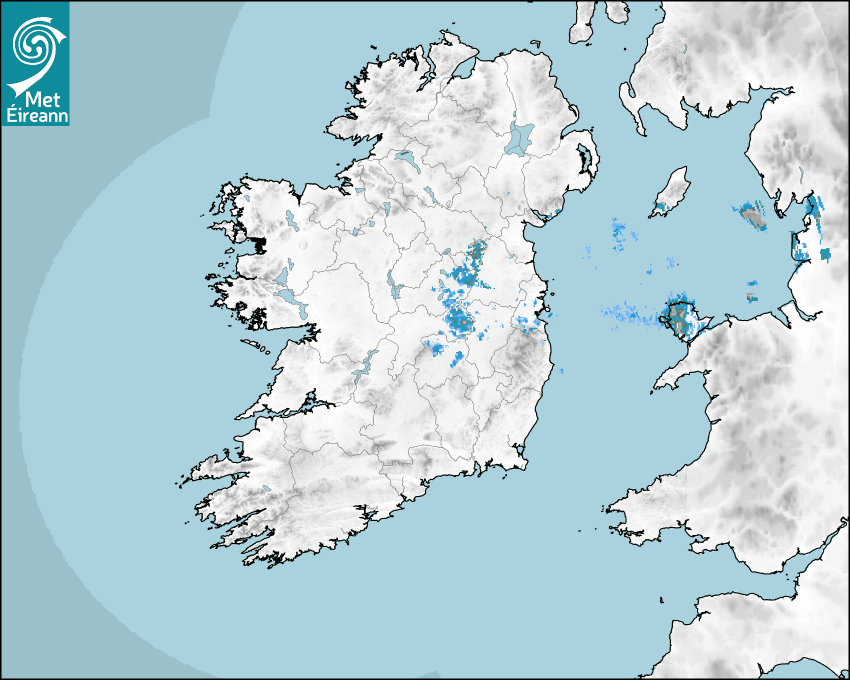

Latest Rainfall Radar showing live precipitation and the last 90 minutes precipitation over Ireland, updated every 5 minutes. Precipitation can be rain, hail or snow. Accumulations can refer to rainfall only.
Lightning strikes, when they occur, are displayed as a cross. Initially, they are red but change to orange and then yellow after a period, then disappear © Met Office ATDNet.
Ground Clutter may appear (South Co. Dublin), bright bands and spokes may also be present in images. They are artefacts (false echoes) of rainfall radar systems and should be ignored. Further information on Radar here
Met Éireann forecasters manually produce the weather icons for midday and midnight to reflect the predicted major weather type for these times.
The rainfall forecast is direct model output from Numerical Weather Prediction models but is a guideline only. Rain refers to precipitation, which can be rain, sleet or snow. It forecasts how much rain will fall (in mm) hourly during the previous hour (accumulations), then in 3 hourly and finally 6 hourly accumulations up to 7 days. This service is based on data and products of the HARMONIE-AROME and the European Centre for Medium-range Weather Forecasts (ECMWF) models.
The wind is direct model output from Numerical Weather Prediction models but is a guideline only. It forecasts the strength of the wind (in knots and km/h) at 10m for the top of each hour, in hourly, then 3 hourly and finally 6 hourly intervals up to 7 days. The wind arrow tip points in the direction the wind is blowing and the tail length indicates wind strength. However, in the text forecast below, it is described as where it is blowing from. This service is based on data and products of the HARMONIE-AROME and the European Centre for Medium-range Weather Forecasts (ECMWF) models.
The temperature is direct model output from Numerical Weather Prediction models but is a guideline only. It forecasts air temperature on land and over sea in °C for the top of each hour, 3 hourly and finally 6 hourly intervals up to 7 days. Minus zero (-0) indicates values between 0 to -0.5°C. This service is based on data and products of the HARMONIE-AROME and the European Centre for Medium-range Weather Forecasts (ECMWF) models.
The Mean Sea Level Pressure (MSLP) is direct model output from Numerical Weather Prediction models but is a guideline only. It forecasts the MSLP in hecto Pascals (hPa) for the top of that hour initially in 3 hourly intervals, then 6 hourly. This service is based on data and products of the HARMONIE-AROME and the European Centre for Medium-range Weather Forecasts (ECMWF) models.
National Forecast
12 July 2025 03:45
Today
Today will be very warm or hot with temperatures reaching 26 to 30 degrees. Any patchy fog in the southwest will clear quickly and it will be dry and sunny with light to moderate southeasterly winds.
Tonight
Mild and dry tonight and feeling humid with lowest temperatures of 14 to 17 degrees with very light southeast or variable breezes.
Tomorrow
Sunday: Starting out largely fine and dry with good sunny spells and mostly light winds. Cloud will build from the west with showery outbreaks of rain pushing in across western and southwestern parts during the afternoon and evening. Some heavy and possibly thundery downpours are possible. A very warm or hot day with highest temperatures of 22 to 29 degrees and light to moderate south to southeast or variable breezes. Turning fresher in the west and south in the evening.
Met News

02nd July 2025
Climate Statement for June 2025
4th warmest June on record, wet and dull for most ... more


05th June 2025
Climate Statement for Spring 2025
Ireland records highest average temperature and ho... more

04th June 2025
Climate Statement for May 2025
Warm, dry, calm and very sunny May for Ireland I... more