Storm Jorge from Space – Saturday 29th of Feb, 2020
By Conor Lally (Meteorologist, Observations Division)
Presented are a series of three satellite images detailing the progression of Storm Jorge (pronounced Hor-hay), the seventh winter storm of the season, as it crossed the country today.
These images are Natural Colour RGB (Red Green Blue) composites courtesy of the European Organisation for the Exploitation of Meteorological Satellites (EUMETSAT). Composite satellite images combine pictures taken at different visible and infra-red frequencies, each of which contains slightly different information. To highlight each picture’s own particular specialty, that is to say those features that are captured best in that particular frequency, they are tinted a different colour. Then when combined together they reveal more information than they would by themselves.
The centre of the storm Jorge, which developed in the mid-Atlantic and deepened rapidly as it approached Ireland thanks to a strong jet stream aloft, was clearly identifiable as the dark patch to the west of the country in the first of our series of satellite photos, which was taken at 9am. At this stage the pressure in the centre of the storm was predicted to be in the region of 950 hPa and the closest of our stations to the centre of the storm, Belmullet in Co Mayo, recorded a Mean Sea Level pressure of 963 hPa.
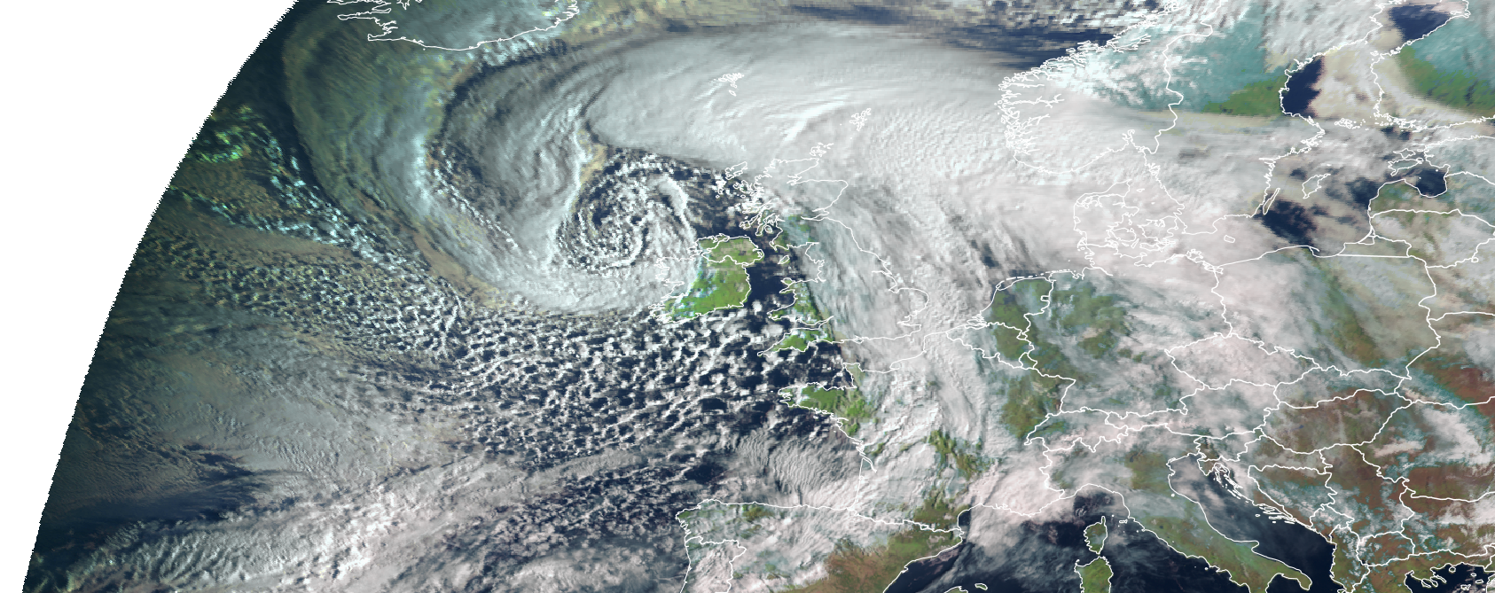
Despite the proximity of the storm centre we can also see that Saturday started off as a bright clear day for many with an absence of cloud for much of the eastern half of the country. However, the storm quickly began make its presence felt shortly after sunrise on the west coast, as a swathe of storm force winds began to drive in across the west of the country by which time our station in Mace Head had already recorded a wind gust of 92 km/hr.
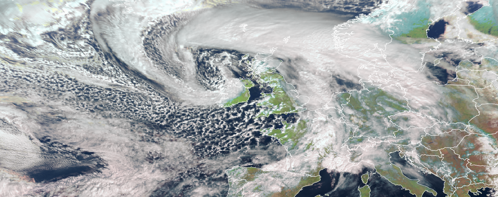
We can see in the second image taken at 11pm the storm’s occluded front, which was visible as the thick band of cloud in the shape of a comma head that is wrapped around the storm’s centre, push its way into to the middle of the country. With the front came heavy rain but also for a short while some sleet and snow along its leading edge. Our station in Knock airport recording 3cm of snow lying by 11am. Looking carefully at our composite image we can just discern this band of frozen precipitation as a light blue streak to the right of the thick white and warmer cloud of the front. The tip of the comma head often contains much of the highest winds and this is evident in the winds recorded at this time with Mace Head, Newport, and Athenry recording gusts of 133, 102 and 98 km/hr.
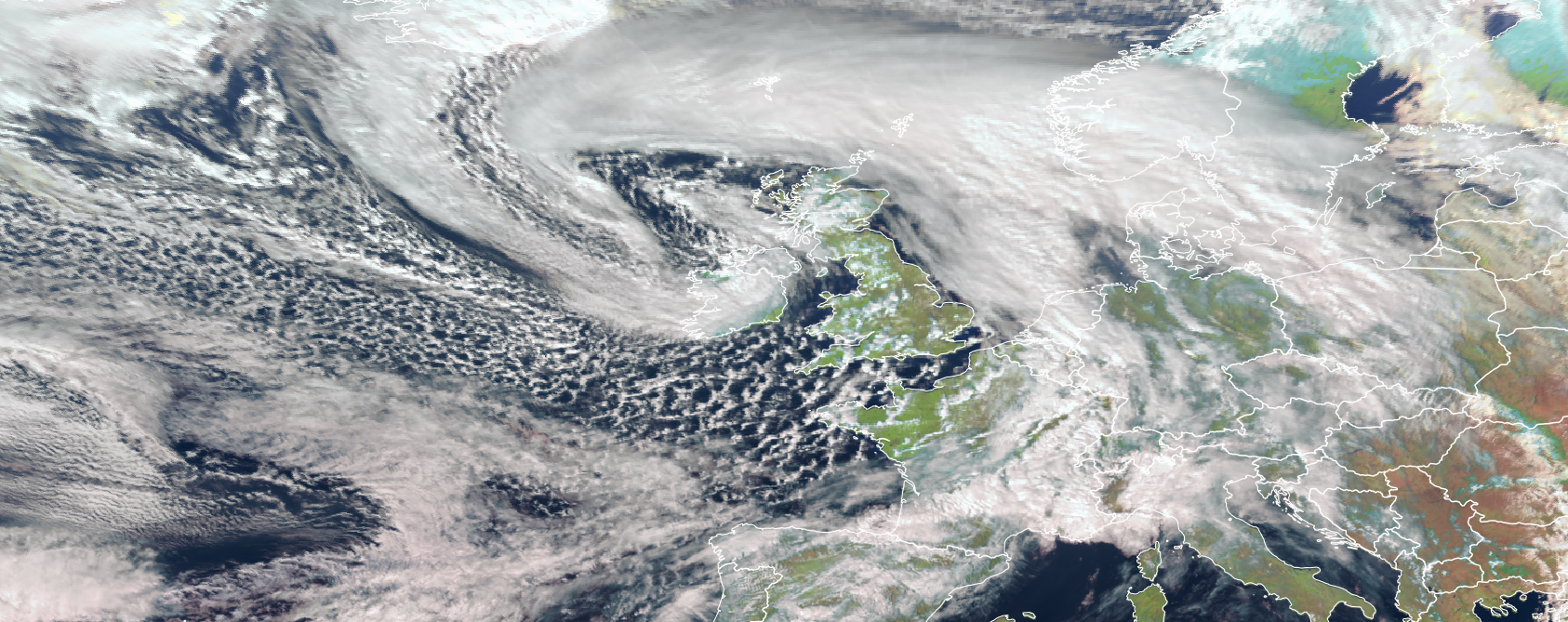
In our third image taken at 1pm, the front has spread across the whole of the country and ‘Jorge’ now shows signs of a maturing system. What was in our first image the tight core of the storm centre has become elongated as cold air, visible in the picture as the dark clear sector east and south of Ireland, was dragged into the centre. This has the effect of cutting the storm off from the supply of warm air which drives it and thus reducing its intensity.
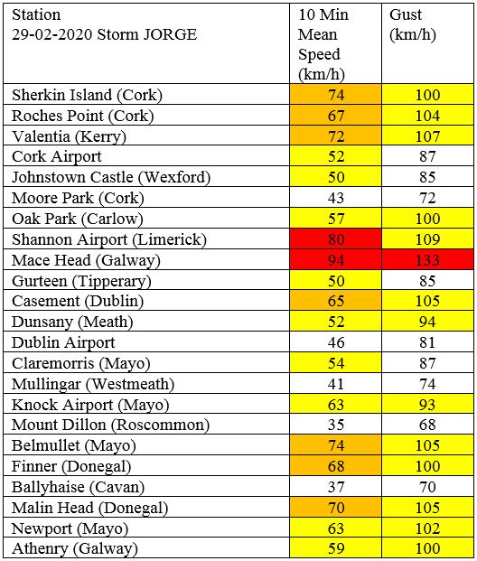
Storm Jorge: highest ten minute means and gusts
Storm Jorge is the seventh named storm of the season. It was originally named by AEMET, the Spanish national meteorological service, due to the impact of the storm’s active cold front which is forecast to bring severe gusts and strong waves to the northwest of Spain.
Here’s the list of the winter storms so far this season:
- Lorenzo, 4–Oct-2019 (Ex-hurricane, named by the NOAA National Hurricane Centre in the USA)
- Atiyah, 8-Dec-2019
- Elsa, 18-Dec-2019 (named by IPMA, the national meteorological service of Portugal)
- Brendan, 13-Jan-2020
- Ciara, 9-Feb-2020
- Dennis, 16-Feb-2020
- Jorge, 29-Feb-2020 (named by AEMET, the national meteorological service of Spain)
Storms are named to aid the communication of approaching severe weather, helping the public to be better placed to keep themselves, their property and businesses safe. Met Éireann are part of a western Europe storm-naming group which includes the Dutch meteorological service, KNMI and the UK’s meteorological service UKMO. The national meteorological services of Spain, Portugal, France (MeteoFrance) and Belgium (RMI) are part of a southwestern Europe storm-naming group which has a separate list of names allocated to the Winter 2019/20 storm season. When a storm has already been officially named by another national meteorological service or the US National Hurricane Centre, that storm name is retained.
Flooding issues
- A) Elevated river levels
Currently river levels are elevated across the country, particularly in the Midlands (Shannon catchment). Levels across the Northern half of the country are also high. Therefore, additional rainfall over the coming days will compound the flooding issues here. - B) Coastal Flooding
We are in a period of transition between Spring (High) Tides and Neap (Low) Tides. This means there will not be a large variation between high and low tides. The combination of high seas and strong winds or stormy conditions associated with Storm Jorge may increase the possibility of coastal flooding, especially in flood-prone areas along the Atlantic coast on Saturday (particularly when coincident with high tides).
Keep up to date
As forecast confidence improves over the coming days Met Éireann will issue warnings as required. Please check for updates on https://www.met.ie/warnings.
Push notifications for all weather warning levels (yellow, orange and red) for your location are available on the latest version of the Met Éireann App.