After a week of persistent rain, many rivers are at or above bank-full conditions. Soils are saturated or waterlogged in many places across the country, increasing the risk of further river and surface water flooding.
Any additional rainfall over the course of the coming few days is expected to result in river and surface water flooding, particularly in the midlands, southern, southeastern, northeastern, and eastern counties. Rivers are expected to overflow their banks, and smaller tributaries may flood more rapidly.
We are also entering a period of high spring tides with strong onshore winds, particularly along southern and eastern coasts. This will increase flood risk in low-lying coastal areas.
Ground Situation
The month of January has been characterised by frequent rainfall and localised extremes. The image below depicts the above normal rainfall amounts countrywide over the past seven days with the largest deviations from the average in the south and east.
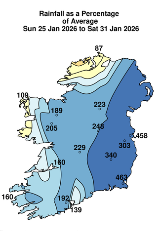
Figure 1: Rainfall: Past seven days
Following recent rainfall, many rivers are at or above bank-full levels. This rainfall, combined with saturated soils, has caused significant rises in river levels and surface water accumulation, particularly across southeastern and eastern areas.
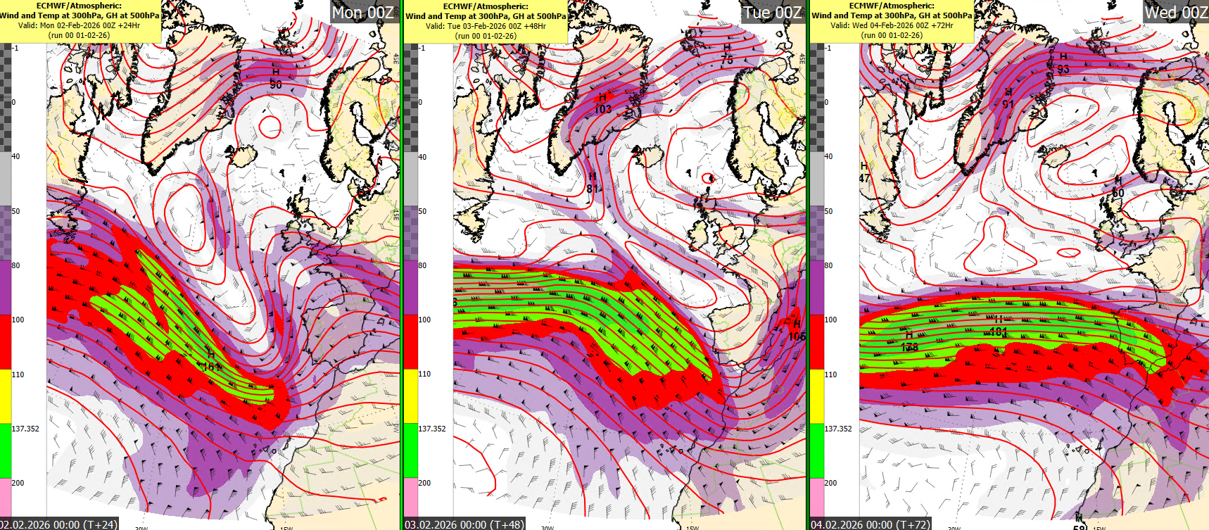
Figure 2: Jetstream from Monday to Wednesday.
A strong jet stream has maintained to our south which is helping to keep an area of low pressure anchored off our southwest coast. This will in turn generate spells of rain over the coming week which will mostly affect counties in the south and east.
Rain will arrive into the south of the country across Munster and south Leinster Monday evening. Below is Met Eireann’s own ensemble members all in close agreement with the rainfall location.
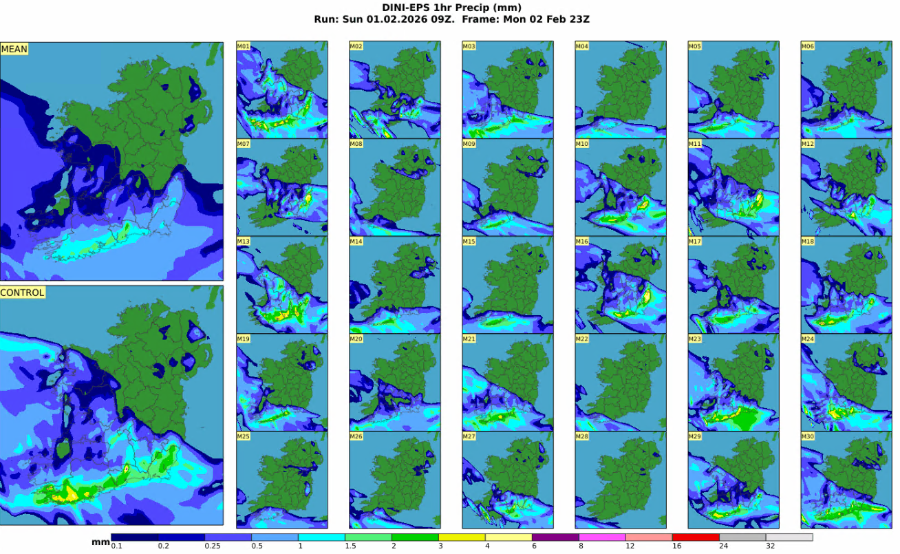
Figure 3: DINI EPS 1hr rainfall.
Taking a further look at our DINI-EPS Probability charts below we can see thresholds for yellow level warnings are increasingly likely in the south and east.
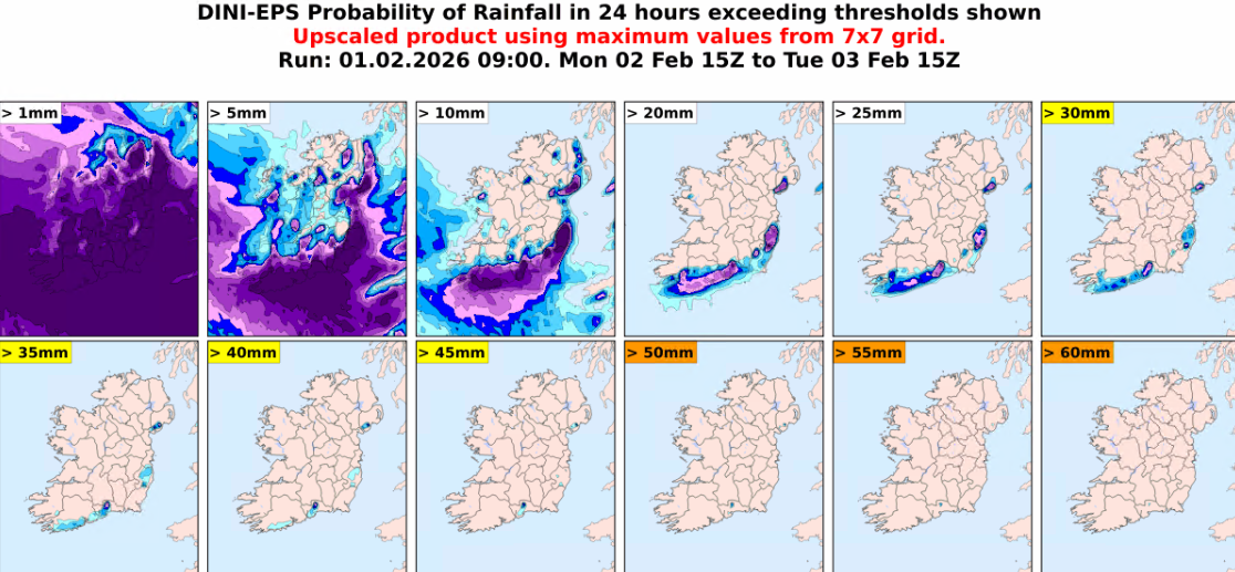
Figure 4: DINI EPS rainfall accumulation probabilities.
With the high river levels in these areas together with saturated ground further river flooding is possible in these locations. Yellow level rainfall warnings have been issued for Monday and into Tuesday with impacts including localised and river flooding.
The latest Met Eireann warnings are here Warnings & Advisories – Met Éireann – The Irish Meteorological Service
High spring tides early next week, combined with strong winds and surge, may cause wave overtopping and coastal flooding along all coasts, especially in low lying coastal areas.
High coastal levels will impede river discharge and increase flood risk in low-lying coastal and estuarine areas, especially at high tide.
For much of the week the winds are expected to be south to southeasterly too which is an onshore direction for counties across Munster and Leinster. This combined with high tides can further exacerbate the synoptic setup.
Looking ahead to the rest of the week and low pressure remains dominant. This in turn will result in spells of rain continuing across the south and east.
Over the coming week more than twice or possibly three times the average amount of rainfall is expected.
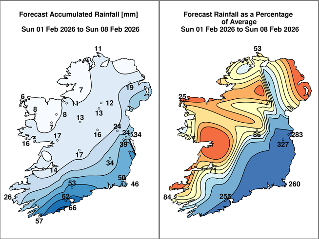
Figure 5: ECMWF rainfall accumulation projections
Taking a closer look across our ECMWF ensemble forecast for rainfall accumulations we can expect between 30 to 45mm from Sunday February 1st until Friday February 6th.
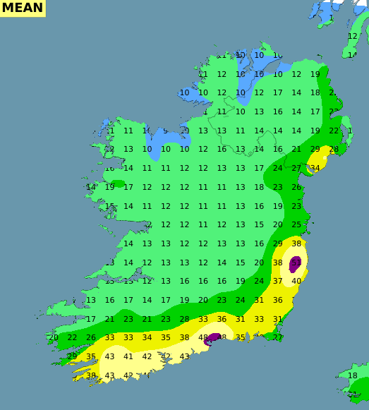
Figure 6: ECMWF mean rainfall accumulations until Friday 6th February.
While this rainfall is expected to come in spells over the course of the next few days starting Monday evening it will fall on already very saturated ground.
The above forecast gives a mean outcome but it’s possible that some accumulations may be slightly above or below the figures seen above.
As such and with the overall unsettled pattern of weather expected, additional rainfall over the coming days in the East, Southeast and South could cause further river flooding. Fast responding and upland catchments are most at risk.
Public Safety Advice
- Monitor Met Éireann forecasts – conditions may change quickly. Visit https://www.met.ie/for the most up to date information. Information is also available across the Met Éireann App, social media platforms (@meteireann) and bulletins.
- Check local authority websites and social media channels for information on road closures, flooding updates, and community alerts.
- Allow for disruption when travelling. Plan extra travel time and reduce speed.
- Expect surface water, debris and poor visibility.
- Do not bypass Road Closed signs – the road ahead is unsafe, the damage may be hidden beneath water, and you may be putting your life at risk.
- Do not drive through floodwater – turn back and use another route.
- Check with Transport Operators when planning journeys
- Stay back from riverbanks, streams and canals – water levels may rise quickly.
- Keep children and pets away from waterways and flooded areas.
- Keep away from coastal edges, harbours, piers and low-lying promenades during high tide.
- The Irish Coast Guard advice remains: “Stay Back, Stay High, Stay Dry.”
- Check in with neighbours, older people or anyone who may need assistance in case conditions worsen.
- Up to date information on the response to Storm Chandra is available at https://www.gov.ie/en/department-of-the-taoiseach/news/storm-response/
Wet weather continues for the start of February with ongoing flood risks for the east and southeast
After a week of persistent rain, many rivers are at or above bank-full conditions. Soils are saturated or waterlogged in many places across the country, increasing the risk of further river and surface water flooding.
Any additional rainfall over the course of the coming few days is expected to result in river and surface water flooding, particularly in the midlands, southern, southeastern, northeastern, and eastern counties. Rivers are expected to overflow their banks, and smaller tributaries may flood more rapidly.
We are also entering a period of high spring tides with strong onshore winds, particularly along southern and eastern coasts. This will increase flood risk in low-lying coastal areas.
Ground Situation
The month of January has been characterised by frequent rainfall and localised extremes. The image below depicts the above normal rainfall amounts countrywide over the past seven days with the largest deviations from the average in the south and east.
Figure 1: Rainfall: Past seven days
Following recent rainfall, many rivers are at or above bank-full levels. This rainfall, combined with saturated soils, has caused significant rises in river levels and surface water accumulation, particularly across southeastern and eastern areas.
Figure 2: Jetstream from Monday to Wednesday.
A strong jet stream has maintained to our south which is helping to keep an area of low pressure anchored off our southwest coast. This will in turn generate spells of rain over the coming week which will mostly affect counties in the south and east.
Rain will arrive into the south of the country across Munster and south Leinster Monday evening. Below is Met Eireann’s own ensemble members all in close agreement with the rainfall location.
Figure 3: DINI EPS 1hr rainfall.
Taking a further look at our DINI-EPS Probability charts below we can see thresholds for yellow level warnings are increasingly likely in the south and east.
Figure 4: DINI EPS rainfall accumulation probabilities.
With the high river levels in these areas together with saturated ground further river flooding is possible in these locations. Yellow level rainfall warnings have been issued for Monday and into Tuesday with impacts including localised and river flooding.
The latest Met Eireann warnings are here Warnings & Advisories – Met Éireann – The Irish Meteorological Service
High spring tides early next week, combined with strong winds and surge, may cause wave overtopping and coastal flooding along all coasts, especially in low lying coastal areas.
High coastal levels will impede river discharge and increase flood risk in low-lying coastal and estuarine areas, especially at high tide.
For much of the week the winds are expected to be south to southeasterly too which is an onshore direction for counties across Munster and Leinster. This combined with high tides can further exacerbate the synoptic setup.
Looking ahead to the rest of the week and low pressure remains dominant. This in turn will result in spells of rain continuing across the south and east.
Over the coming week more than twice or possibly three times the average amount of rainfall is expected.
Figure 5: ECMWF rainfall accumulation projections
Taking a closer look across our ECMWF ensemble forecast for rainfall accumulations we can expect between 30 to 45mm from Sunday February 1st until Friday February 6th.
Figure 6: ECMWF mean rainfall accumulations until Friday 6th February.
While this rainfall is expected to come in spells over the course of the next few days starting Monday evening it will fall on already very saturated ground.
The above forecast gives a mean outcome but it’s possible that some accumulations may be slightly above or below the figures seen above.
As such and with the overall unsettled pattern of weather expected, additional rainfall over the coming days in the East, Southeast and South could cause further river flooding. Fast responding and upland catchments are most at risk.
Public Safety Advice
About Us