Updated, January 26th at 19:45 and valid until further notice
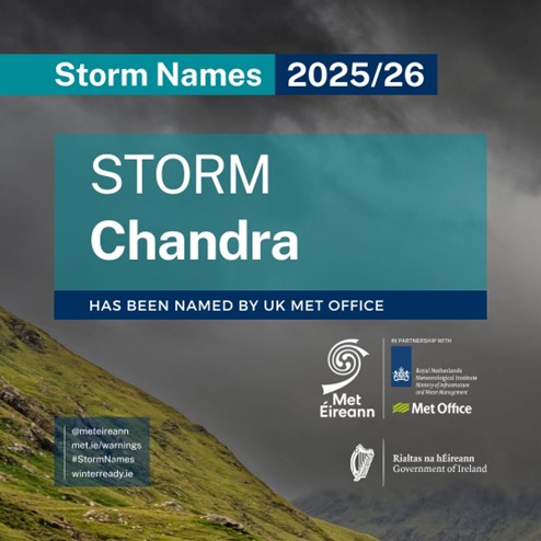
A low-pressure system, named Storm Chandra by the UK Met Office, will bring strong winds and heavy rain to Ireland from the night of Monday, January 26th and during Tuesday, January 27th.
Meteorologist Rebecca Cantwell, says:
“Storm Chandra is a low-pressure system that will track northwards over the country Monday night and Tuesday, bringing with it rather wet and windy conditions. It will bring heavy spells of rain with strong winds, especially along the coast. It will slowly clear northwards later on Tuesday.
Given the unsettled spell of weather we’ve experienced over the last while, this rain will fall on already saturated ground, combined with the fact that many rivers are approaching or exceeding bank-full conditions, and so we are expecting localised flooding and river flooding as a result. We have issued yellow level rainfall warnings for southeastern counties where the rain is expected to have the greatest impacts.
This rain will also be accompanied by strong and gusty winds, affecting especially coastal areas, so yellow wind warning has been issued for the entire country.”
Rebecca continues:
“The compound effect of the wind and rain will make for some difficult travelling conditions during the validity period of the warnings and so we would urge people to keep that in mind when out and about. The winds will be strongest near coasts and exposed areas with wave overtopping possible and so we echo the well-known advice of the Irish Coast Guard: “Stay Back, Stay High, Stay Dry”. In summary, stay back from rivers, lakes and the coasts and avoid flooded roads, following the latest guidance from your local authority and road authorities.”
METEOROLOGICAL SITUATION
A strong polar front jet, as a result of the cold air outbreak over North America, will see the system deepen rapidly to the south of Ireland within the left exit of the jet stream. The storm will approach the south coast overnight before tracking northwards over Ireland during Tuesday.
Fig. 1: Wet bulb potential temperature
Initially a band of persistent rain will push up from the southeast bringing widespread rainfall. The system is forecast to meet a relatively cool airmass as it moves northwards, bringing the potential for mixed precipitation with a chance of falls of sleet over higher ground in the north and northwest in the morning. This rain will clear northwards and will be followed by a brief period of drier and brighter weather before the same system swings back around and feeds further outbreaks of rain up over the country. Wet and windy conditions will affect all areas with southern and eastern counties expected to see the highest rainfall accumulations.
Fig. 2: The current DINI model prediction of the rainfall, at the time of publication on Monday 26th January, subject to changes.
WARNINGS AND IMPACTS: Met Éireann has issued the following warnings (on 26th January at time of publication):
A Status Yellow rain warning across southeastern counties, with heavy and persistent rain expected to fall on already saturated ground and with many rivers approaching bank full conditions after a spell of wet and unsettled weather.
Potential impacts are:
- Localised coastal, surface and river flooding,
- After recent rainfall, many rivers are approaching or exceeding bank-full conditions. Forecast heavy rainfall is likely to result in river flooding, particularly in flood-prone catchments. Waterlogged soils will reduce infiltration and increase overland flow.
- Large rivers may overflow their banks, while smaller rivers and streams may respond more rapidly and flood sooner. This may lead to floodplains, agricultural land and low-lying roads being flooded.
- The flood risk will persist from Wednesday into Thursday due to continued forecast rainfall and slow drainage from saturated ground.
- Strong onshore winds and high waves may cause wave over-topping and flooding in low-lying coastal areas.
- Difficult travel conditions
- Potential disruption to outdoor events
A nationwide Status Yellow wind warning due to strong and gusty winds associated with Storm Chandra, strongest along the coasts and exposed areas.
Potential impacts include:
- Hazardous travel conditions
- Potential disruption to outdoor events
The warnings may be updated as new model runs are analysed and certainty increases. For the latest warnings details, please check Warnings & Advisories – Met Éireann – The Irish Meteorological Service
HOW TO STAY SAFE IN SEVERE WEATHER – BE WINTER READY
Stay informed & plan ahead:
- Stay up-to date with the forecast and the warnings for your county on met.ie, the Met Éireann app or Met Éireann socials (@meteireann).
- Check in with your local authority and emergency management stakeholders (Irish Coast Guards, Gardaí, etc) via their websites and social channels on road closures, flooding updates, and community alerts.
- Allow for disruption during Tuesday morning and evening commutes.
- Plan extra travel time and reduce speed.
- Expect surface water, debris and poor visibility on
- Check in with neighbours, older people or anyone who may need assistance in case conditions worsen.
This is a multi-hazard event – be aware of elevated flood risk and strong winds:
- Coastal areas are likely to experience wave overtopping especially in low-lying locations.
- Keep away from coastal edges, harbours, piers and low-lying promenades during high tide. The Irish Coast Guard advice remains: “Stay Back, Stay High, Stay Dry.”
- Stay back from riverbanks, streams and canals – water levels may rise quickly.
- Keep children and pets away from waterways and flooded areas.
- Don’t try to walk, cycle or drive through flooded areas – turn back and use another route.
- Remember: As little as 150mm of fast-flowing water can knock you off your feet and 300mm of fast-flowing water can move most cars off the road.
- Ensure your mobile is phone is fully charged to enable communication in advance of the event and keep local emergency numbers in your phone.
- Take care on exposed roads and bridges.
- Watch for fallen branches and debris.
- Allow extra time for your trip and if you are driving a high sided vehicle, try to anticipate exposed sections of roadway where winds will be stronger.
- Secure loose outdoor items ahead of strengthening winds.
- ESB Networks is highlighting the dangers posed by fallen live wires and is advising the public and the emergency services to stay away from these fallen cables and to report such cases to it immediately. ESB Emergency Services can be contacted at 1800 372 999.
- The public can monitor PowerCheck.ie in regard to power restoration times.
- Keep a small amount of food, medical and water supplies in case it’s dangerous to step out of the home.
- Uisce Éireann customers can check the website and social media channels for updates and to get in touch with any issues or concerns via their 24/7 customer care centre at 1800 278 278. The public can also sign up online to their free text alert system to get regular updates about their local supplies – see water.ie.”
- “Be Winter Ready”: Follow recommendations before, during and after the event on gov.ie – Be Winter Ready
NOTE THAT: The warnings are likely to be updated. Please keep in touch with Met Éireann’s social media channels, www.met.ie and the Met Éireann app to stay up to date with the forecast and any warnings’ updates.
The timing and location of extreme weather occurrences can significantly affect their impact. It’s important to note that in any individual weather event, not every location within a warning area may experience the same degree of weather or impacts.
When severe weather is expected, weather and impacts at lower levels are also likely to be experienced. The type and level of impacts can be strongly affected by previous weather conditions. When issuing a warning, Met Éireann takes into consideration the forecast conditions and thresholds, as well as previous weather conditions that may increase the level of impact expected for particular areas.
WHY AND HOW ARE STORMS NAMED?
Storms are named when they could cause ‘medium’ or ‘high’ impacts in one of the three partner countries. This enables consistent, authoritative messaging to the public and other stakeholders to help them to prepare for and stay safe during potentially severe weather events.
Since 2015, Met Éireann and the UK Met Office have been working together on the naming programme and were joined by the Netherlands’ KNMI in 2019, to form the ‘western group’ of European weather services.
When a storm is forecast, the national weather service that expects the biggest impact from the severe weather to hit its region, or is likely to be first affected by it, names the storm. Storm naming happens in conjunction with orange/red weather warnings, which could be for wind, rain or snow, or a combination of these conditions. Those warnings are, in turn, issued based on a combination of numerical thresholds and the potential impacts foreseen.
HOW ARE STORM NAMES CHOSEN?
Met Éireann, the UK Met Office and KNMI publish a new list of storm names for each Storm Season, which commences on 1st September.
This 2025/26 season, each of the three meteorological services contributed seven names to the season’s list. Met Éireann called on Ireland’s public to submit their preferred names through a social media campaign. More than 10,000 names were received from 4,137 members of the public.
The full 2025/26 list is Amy, Bram, Chandra, Dave, Eddie, Fionnuala, Gerard, Hannah, Isla, Janna, Kasia, Lilith, Marty, Nico, Oscar, Patrick, Ruby, Stevie, Tadhg, Violet, Wubbo.
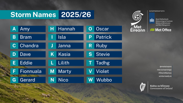
Figure 3– Storm Names 2025/26 list (The names chosen by Met Éireann are in bold. Letters Q, U, X, Y, Z are not included, which is in line with the US National Hurricane Center naming convention).
JANUARY STORMS IN IRELAND
January storms are a normal part of the Irish climate, with the Atlantic storm track often at its most active, so we commonly see spells of widespread rain, strong to gale force winds, very rough seas, coastal overtopping, and a higher flooding risk when soils and rivers are already bank full. It is not unusual to have a strong jet stream in January, it is quite typical. Currently the jet stream is to our south rather than to the north.
Since the storm naming project began, three of the eleven storm seasons (2017, 2019 and 2023) had no storms in January.
The historical record shows the range from disruptive to extreme: the Night of the Big Wind on 6 to 7 January 1839 was about 187 years ago, the major windstorm of 5 January 1991 was about 35 years ago, Violent Storm Isha on 21 January 2024 was just over 2 years ago, and Hurricane strength Éowyn on 24 January 2025 was just over 1 year ago, showing that while January storminess is expected, the standout events are less frequent and tend to be remembered for decades.
- 2024/25: Éowyn 24-Jan: wind, highest daily synoptic rain: 28.5 mm
- 2023/24: Henk (Strong Breeze 2-Jan)
- Isha (Violent storm 21-Jan) : wind, highest daily rain: 36.2 mm
- Jocelyn (Storm force 23-Jan): wind, highest daily rain: 19.2 mm
- 2021/22: Corrie (Gale Force 30-Jan – Malik (Gale Force, 29-Jan)
- 2020/21: Christoph (Near Gale 21-Jan)
- 2019/20: Brendan (Storm force 13-Jan): wind, highest daily rain: 34.0 mm
- 2017/18: Eleanor (Violent storm 2-Jan): wind, highest daily rain: 38.2 mm
- Fionn (Storm force 16-Jan) wind, highest daily rain: 37.8 mm
- David (17-Jan)
- Georgina (Gale Force 23-Jan): highest daily rain: 42.0 mm
- 2015/16: Gertrude (Storm Force 29-Jan) highest daily rain: 65.9 mm
PAST STORM SEASONS OVERVIEW
- In the past season (2024/25), there were six named storms affecting the area, starting with Ashley (October 2024), Bert, Conall, Darragh, Éowyn and closing with Floris (August 2025). All of these storms were named by the Western Europe Group of National Meteorological Services, formed by the UK Met Office, KNMI and Met Éireann.
- The highest number of named storms in a season, affecting Ireland, is fourteen (14), in 2023/24. Two of these storms (Elisa and Geraldine) were named by the Southwestern Europe Group (France, Portugal and Spain). The lowest number of named storms, affecting Ireland, since the initiative began, was four, in 2022/23.
- On average, there have been around eight named storms each season since the storm naming initiative began in 2015.
- 2015/16 remains the season with the greatest number of storms reaching storm force 10, when nine of the 11 named storms observed storm force 10 or higher sustained wind speeds at coastal stations.
- Last season 2024/25, four (of the six) named storms observed storm force 10 or higher sustained wind speeds on land in Ireland:
- Ashley on Sunday 20th October 2024, with gusts up to 137 km/h (Storm Force).
- Bert on Saturday 23rd November 2024, with gusts up 115 km/h (Storm Force).
- Darragh on Friday 6th December 2024, with gusts up to 141 km/h (Violent Storm Force).
- Éowyn on Friday 24th January 2025, with gusts up to 184 km/h (Hurricane Force).
- Prior to Storm Éowyn, the last hurricane force winds observed on land for Ireland were during Storm Darwin on Wednesday, 12th February 2014, when gusts reached up to 159 km/h.
- During Storm Éowyn, a gust of 184km/h was recorded at Mace Head Co. Galway on 24th January 2025. This is provisionally the strongest gust speed ever recorded in Ireland, breaking the previous record of 182km/h set at Foynes, Co. Limerick in 1945.
For more information on storm names and past storms, see Storm Centre and Major Weather Events.
Storm Chandra Impacting Eastern and Southern counties on Tuesday, 27th January 2026
Updated, January 26th at 19:45 and valid until further notice
A low-pressure system, named Storm Chandra by the UK Met Office, will bring strong winds and heavy rain to Ireland from the night of Monday, January 26th and during Tuesday, January 27th.
Meteorologist Rebecca Cantwell, says:
“Storm Chandra is a low-pressure system that will track northwards over the country Monday night and Tuesday, bringing with it rather wet and windy conditions. It will bring heavy spells of rain with strong winds, especially along the coast. It will slowly clear northwards later on Tuesday.
Given the unsettled spell of weather we’ve experienced over the last while, this rain will fall on already saturated ground, combined with the fact that many rivers are approaching or exceeding bank-full conditions, and so we are expecting localised flooding and river flooding as a result. We have issued yellow level rainfall warnings for southeastern counties where the rain is expected to have the greatest impacts.
This rain will also be accompanied by strong and gusty winds, affecting especially coastal areas, so yellow wind warning has been issued for the entire country.”
Rebecca continues:
“The compound effect of the wind and rain will make for some difficult travelling conditions during the validity period of the warnings and so we would urge people to keep that in mind when out and about. The winds will be strongest near coasts and exposed areas with wave overtopping possible and so we echo the well-known advice of the Irish Coast Guard: “Stay Back, Stay High, Stay Dry”. In summary, stay back from rivers, lakes and the coasts and avoid flooded roads, following the latest guidance from your local authority and road authorities.”
METEOROLOGICAL SITUATION
A strong polar front jet, as a result of the cold air outbreak over North America, will see the system deepen rapidly to the south of Ireland within the left exit of the jet stream. The storm will approach the south coast overnight before tracking northwards over Ireland during Tuesday.
Fig. 1: Wet bulb potential temperature
Initially a band of persistent rain will push up from the southeast bringing widespread rainfall. The system is forecast to meet a relatively cool airmass as it moves northwards, bringing the potential for mixed precipitation with a chance of falls of sleet over higher ground in the north and northwest in the morning. This rain will clear northwards and will be followed by a brief period of drier and brighter weather before the same system swings back around and feeds further outbreaks of rain up over the country. Wet and windy conditions will affect all areas with southern and eastern counties expected to see the highest rainfall accumulations.
Fig. 2: The current DINI model prediction of the rainfall, at the time of publication on Monday 26th January, subject to changes.
WARNINGS AND IMPACTS: Met Éireann has issued the following warnings (on 26th January at time of publication):
A Status Yellow rain warning across southeastern counties, with heavy and persistent rain expected to fall on already saturated ground and with many rivers approaching bank full conditions after a spell of wet and unsettled weather.
Potential impacts are:
A nationwide Status Yellow wind warning due to strong and gusty winds associated with Storm Chandra, strongest along the coasts and exposed areas.
Potential impacts include:
The warnings may be updated as new model runs are analysed and certainty increases. For the latest warnings details, please check Warnings & Advisories – Met Éireann – The Irish Meteorological Service
HOW TO STAY SAFE IN SEVERE WEATHER – BE WINTER READY
Stay informed & plan ahead:
This is a multi-hazard event – be aware of elevated flood risk and strong winds:
NOTE THAT: The warnings are likely to be updated. Please keep in touch with Met Éireann’s social media channels, www.met.ie and the Met Éireann app to stay up to date with the forecast and any warnings’ updates.
The timing and location of extreme weather occurrences can significantly affect their impact. It’s important to note that in any individual weather event, not every location within a warning area may experience the same degree of weather or impacts.
When severe weather is expected, weather and impacts at lower levels are also likely to be experienced. The type and level of impacts can be strongly affected by previous weather conditions. When issuing a warning, Met Éireann takes into consideration the forecast conditions and thresholds, as well as previous weather conditions that may increase the level of impact expected for particular areas.
WHY AND HOW ARE STORMS NAMED?
Storms are named when they could cause ‘medium’ or ‘high’ impacts in one of the three partner countries. This enables consistent, authoritative messaging to the public and other stakeholders to help them to prepare for and stay safe during potentially severe weather events.
Since 2015, Met Éireann and the UK Met Office have been working together on the naming programme and were joined by the Netherlands’ KNMI in 2019, to form the ‘western group’ of European weather services.
When a storm is forecast, the national weather service that expects the biggest impact from the severe weather to hit its region, or is likely to be first affected by it, names the storm. Storm naming happens in conjunction with orange/red weather warnings, which could be for wind, rain or snow, or a combination of these conditions. Those warnings are, in turn, issued based on a combination of numerical thresholds and the potential impacts foreseen.
HOW ARE STORM NAMES CHOSEN?
Met Éireann, the UK Met Office and KNMI publish a new list of storm names for each Storm Season, which commences on 1st September.
This 2025/26 season, each of the three meteorological services contributed seven names to the season’s list. Met Éireann called on Ireland’s public to submit their preferred names through a social media campaign. More than 10,000 names were received from 4,137 members of the public.
The full 2025/26 list is Amy, Bram, Chandra, Dave, Eddie, Fionnuala, Gerard, Hannah, Isla, Janna, Kasia, Lilith, Marty, Nico, Oscar, Patrick, Ruby, Stevie, Tadhg, Violet, Wubbo.
Figure 3– Storm Names 2025/26 list (The names chosen by Met Éireann are in bold. Letters Q, U, X, Y, Z are not included, which is in line with the US National Hurricane Center naming convention).
JANUARY STORMS IN IRELAND
January storms are a normal part of the Irish climate, with the Atlantic storm track often at its most active, so we commonly see spells of widespread rain, strong to gale force winds, very rough seas, coastal overtopping, and a higher flooding risk when soils and rivers are already bank full. It is not unusual to have a strong jet stream in January, it is quite typical. Currently the jet stream is to our south rather than to the north.
Since the storm naming project began, three of the eleven storm seasons (2017, 2019 and 2023) had no storms in January.
The historical record shows the range from disruptive to extreme: the Night of the Big Wind on 6 to 7 January 1839 was about 187 years ago, the major windstorm of 5 January 1991 was about 35 years ago, Violent Storm Isha on 21 January 2024 was just over 2 years ago, and Hurricane strength Éowyn on 24 January 2025 was just over 1 year ago, showing that while January storminess is expected, the standout events are less frequent and tend to be remembered for decades.
PAST STORM SEASONS OVERVIEW
For more information on storm names and past storms, see Storm Centre and Major Weather Events.
About Us