By Meteorologist Paul Downes
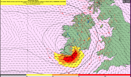
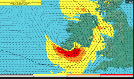
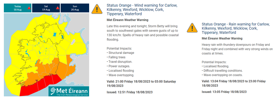
Storm Betty is rapidly developing to the south of Ireland and will impact the country through the rest of the day and overnight. Very strong winds and heavy rainfall are expected, with Cork, Waterford, Tipperary, Wexford, Kilkenny, Carlow and Wicklow likely to get the brunt of Storm Betty winds and rain with south to southwest gales and severe gusts of up to 130 km/hr. An Orange wind warning will be in effect from 9pm Friday the 18th until 3am on Saturday the 19th There is also a status orange rainfall warning for the same counties currently in effect and which will last until 11pm on Friday.
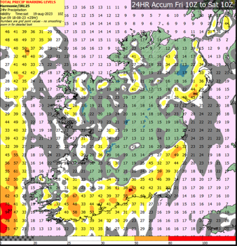
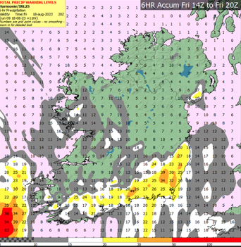
The rain will precede the wind through this afternoon and evening with the potential for some high accumulations over a short period of time likely to lead to localised flooding. There is likely to be some wave overtopping along south, south-eastern and eastern coasts also.
Further status yellow wind warnings will come into effect for Munster and Leinster later today. The UK Met Office has also issued a status yellow wind warning for Down and Antrim from this evening. Further counties may be increased to Orange level in the coming hours so please keep in touch with the latest forecasts and warnings.
Status yellow rainfall warnings are in effect for the entire country. The UK Met Office have also issued status yellow rainfall warnings for Northern Ireland.
Potential impacts especially within the orange warning areas are: Structural damage, falling trees, travel disruption, power outages, localised flooding, wave overtopping.
*Update at 5pm on Friday: A Status Red – Marine Storm warning has been issued from Carnsore Point to Dungarvan to Mizen Head as southeast winds, veering southwesterly increasing to storm force 10, and occasionally violent storm force 11 for a time on Irish coastal waters.
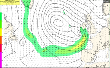
An unseasonably strong jet streak (a more intense area of winds embedded in the jet stream) is currently helping to rapidly intensify Storm Betty to the south of Ireland. Storm Betty will track up across the country today (Friday 18th) and overnight before weakening and clearing away to the north on Saturday morning (19th).
As the very strong winds are unseasonable and trees are in full leaf, very difficult travelling conditions are expected. Whether in the yellow or orange warning areas, temporary structures should be secured adequately. The strong winds will also provide a danger to high sided vehicles.
As Storm Betty is rapidly developing, further warnings may be issued in the coming hours and close monitoring of the situation is advised.
Storm Betty to Impact Ireland Friday 18th August 2023 - updated at 5pm
By Meteorologist Paul Downes
Storm Betty is rapidly developing to the south of Ireland and will impact the country through the rest of the day and overnight. Very strong winds and heavy rainfall are expected, with Cork, Waterford, Tipperary, Wexford, Kilkenny, Carlow and Wicklow likely to get the brunt of Storm Betty winds and rain with south to southwest gales and severe gusts of up to 130 km/hr. An Orange wind warning will be in effect from 9pm Friday the 18th until 3am on Saturday the 19th There is also a status orange rainfall warning for the same counties currently in effect and which will last until 11pm on Friday.
The rain will precede the wind through this afternoon and evening with the potential for some high accumulations over a short period of time likely to lead to localised flooding. There is likely to be some wave overtopping along south, south-eastern and eastern coasts also.
Further status yellow wind warnings will come into effect for Munster and Leinster later today. The UK Met Office has also issued a status yellow wind warning for Down and Antrim from this evening. Further counties may be increased to Orange level in the coming hours so please keep in touch with the latest forecasts and warnings.
Status yellow rainfall warnings are in effect for the entire country. The UK Met Office have also issued status yellow rainfall warnings for Northern Ireland.
Potential impacts especially within the orange warning areas are: Structural damage, falling trees, travel disruption, power outages, localised flooding, wave overtopping.
*Update at 5pm on Friday: A Status Red – Marine Storm warning has been issued from Carnsore Point to Dungarvan to Mizen Head as southeast winds, veering southwesterly increasing to storm force 10, and occasionally violent storm force 11 for a time on Irish coastal waters.
An unseasonably strong jet streak (a more intense area of winds embedded in the jet stream) is currently helping to rapidly intensify Storm Betty to the south of Ireland. Storm Betty will track up across the country today (Friday 18th) and overnight before weakening and clearing away to the north on Saturday morning (19th).
As the very strong winds are unseasonable and trees are in full leaf, very difficult travelling conditions are expected. Whether in the yellow or orange warning areas, temporary structures should be secured adequately. The strong winds will also provide a danger to high sided vehicles.
As Storm Betty is rapidly developing, further warnings may be issued in the coming hours and close monitoring of the situation is advised.
About Us