Overview
Given recent rainfall, river levels and antecedent conditions, further flooding is possible in the south, southeast, midlands, east and northeast on Wednesday and into Thursday. Rain and wind warnings have been issued for Wednesday, and a rain and snow warning has also been issued for Donegal.
Spring tides over the coming days, combined with strong winds and storm surge, may impede river discharge and increase flood risk in low-lying coastal and estuarine areas, particularly at high tide.
Situation
Atlantic low pressure continues to drive our weather pattern, and we have another low-pressure system approaching Ireland today and that’s going to bring fairly widespread spells of heavy rain overnight and Wednesday. The eastern half of the country will see the highest accumulations of rainfall with the rain tending to clear western areas by the early afternoon. Coupled with that rain, which will be heavy at times bringing a risk of surface and river flooding, strong and gusty southeasterly winds are also expected to develop with gales developing on coasts. The strongest winds in the east are going to coincide with high tide along the east coast on Wednesday morning so there is a risk of wave overtopping and coastal flooding of low-lying flood prone areas. In the northwest, the rain will meet cold air so it may fall as sleet or snow for a time, especially on high ground before transitioning back to rain later in the day. It will be very windy in the west and northwest too.
The trend of wetter than average conditions in the east and south has continued into February with parts of the east experiencing 3 to 4 times the average rainfall amounts that would normally be expected during the first 2 weeks of February. The image below depicts the rainfall amounts countrywide over the past fourteen days with the largest deviations from the average in the east.
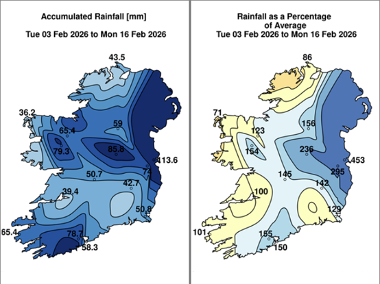
Figure 1: Rainfall: Past fourteen days
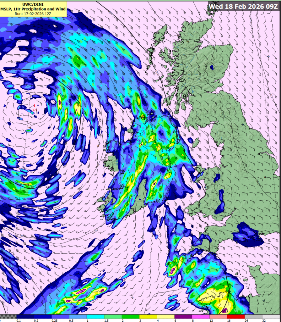
Figure 2: DINI Rain & Winds forecast for Wednesday
Public Safety Advice
- Monitor Met Éireann forecasts – conditions may change quickly. Visit https://www.met.ie/ for the most up to date information. Information is also available across the Met Éireann App, social media platforms (@meteireann) and bulletins.
- Check local authority websites and social media channels for information on road closures, flooding updates, and community alerts.
- Allow for disruption when travelling. Plan extra travel time and reduce speed.
- Expect surface water, debris and poor visibility.
- Do not bypass Road Closed signs – the road ahead is unsafe, the damage may be hidden beneath water, and you may be putting your life at risk.
- Do not drive through floodwater – turn back and use another route.
- Check with Transport Operators when planning journeys
- Stay back from riverbanks, streams and canals – water levels may rise quickly.
- Keep children and pets away from waterways and flooded areas.
- Keep away from coastal edges, harbours, piers and low-lying promenades during high tide.
- The Irish Coast Guard advice remains: “Stay Back, Stay High, Stay Dry.”
- Check in with neighbours, older people or anyone who may need assistance in case conditions worsen.
- ESB Emergency Services can be contacted at 1800 372 999. The public can monitor www.PowerCheck.ie. in regards to power restoration times.
- Uisce Éireann customers can check the website and social media channels for updates and to get in touch with any issues or concerns via their 24/7 customer care centre at 1800 278 278. The public can also sign up online to their free text alert system to get regular updates about their local supplies – see www.water.ie.
- Check River levels on waterlevel.ie
Feb 17: Risk of further flooding as unsettled weather continues
Overview
Given recent rainfall, river levels and antecedent conditions, further flooding is possible in the south, southeast, midlands, east and northeast on Wednesday and into Thursday. Rain and wind warnings have been issued for Wednesday, and a rain and snow warning has also been issued for Donegal.
Spring tides over the coming days, combined with strong winds and storm surge, may impede river discharge and increase flood risk in low-lying coastal and estuarine areas, particularly at high tide.
Situation
Atlantic low pressure continues to drive our weather pattern, and we have another low-pressure system approaching Ireland today and that’s going to bring fairly widespread spells of heavy rain overnight and Wednesday. The eastern half of the country will see the highest accumulations of rainfall with the rain tending to clear western areas by the early afternoon. Coupled with that rain, which will be heavy at times bringing a risk of surface and river flooding, strong and gusty southeasterly winds are also expected to develop with gales developing on coasts. The strongest winds in the east are going to coincide with high tide along the east coast on Wednesday morning so there is a risk of wave overtopping and coastal flooding of low-lying flood prone areas. In the northwest, the rain will meet cold air so it may fall as sleet or snow for a time, especially on high ground before transitioning back to rain later in the day. It will be very windy in the west and northwest too.
The trend of wetter than average conditions in the east and south has continued into February with parts of the east experiencing 3 to 4 times the average rainfall amounts that would normally be expected during the first 2 weeks of February. The image below depicts the rainfall amounts countrywide over the past fourteen days with the largest deviations from the average in the east.
Figure 1: Rainfall: Past fourteen days
Figure 2: DINI Rain & Winds forecast for Wednesday
Public Safety Advice
About Us