August 2021 : Mild and changeable, dry finish
The first week of August 2021 was showery with low-pressure becoming more dominant as the week progressed. After a dry start, pressure gradually dropped, culminating in a relatively deep area of low-pressure becoming slow moving over the northern half of the country between the 5th and 9th. This brought heavy and thundery downpours to many places, especially between the 5th and 7th. As the low-pressure filled and gradually pulled away to the north at the beginning of the second week the showers became less widespread. Atlantic depressions, which mostly stayed to the west and north of Ireland, continued to dominate the weather for the rest of the second, third and beginning of the fourth weeks, bringing further bands of rain or showers across the country from the west and south interspersed with dry periods and sunny spells. There was some heavy falls in places, which were especially widespread on the 20th and 21st, but in general, rainfall amounts stayed relatively low. It became mostly dry and settled from the 22nd up to the end of the month as high pressure built to the north of Ireland, blocking any active weather fronts from approaching. This brought a lot of warm sunny weather between the 23rd and 28th, especially in the west, but as the high pressure moved slightly to the northwest of Ireland towards the end of the month, cloud, mist and night-time fog become more prevalent.
Rainfall: Below average in the South and East, above average in the Northwest
The majority of monthly rainfall totals across the country were below their Long-Term Average (LTA). Percentage of monthly rainfall values ranged from 54% (monthly rainfall total of 47.9 mm) at Sherkin Island, Co Cork to 173% (the month’s highest monthly rainfall total of 176.1 mm) at Markree, Co Sligo. Monthly rainfall totals for the month were lowest at Casement Aerodrome, Co Dublin with 47.3 mm (65% of its LTA). The highest daily rain-fall total was 71.1 mm at Mullingar, Co Westmeath on Thursday 5th (its highest daily value for August on record (length 71 years)). The number of rain days ranged from 11 days at Oak Park, Co Carlow to 23 days at Sherkin Island, Co Cork. The number of wet days ranged from 8 days at Roche’s Point, Co Cork to 17 days at Markree, Co Sligo. The number of very wet days ranged from zero days at Sherkin Island, Co Cork to 6 days at both Ballyhaise, Co Cavan and Markree, Co Sligo.
Temperature: Above average in most places, warmest in the Northwest
Nearly all mean air temperatures were above their Long-Term Average (LTA) for the month. Deviations from mean air temperature ranged from -0.5 °C (14.7 °C mean temperature) at Dublin Airport, Co Dublin to 1.0 °C (14.7 °C , 16.4 °C mean temperature) at Knock Airport, Co Mayo and Newport, Co Mayo respectively. Mean temperatures for the month ranged from 14.4 °C (0.1 °C below its LTA) at Malin Head, Co Donegal to 16.4 °C (1.0 °C above its LTA) at Newport, Co Mayo. The month’s highest temperature was reported at Athenry, Co Galway on Thursday 26th with a temperature of 26.3 °C (its highest max temperature for August since 1976). Both the month’s lowest air and grass minimum temperature were recorded on Monday 2nd Aug at Mount Dillon, Co Roscommon. The lowest air minimum was 4.5 °C while the lowest grass minimum was -0.4 °C. There was no air frost reported this month. The only station to report ground frost was Mount Dillon, Co Roscommon. The number of days with ground frost ranged from zero days at most stations to 1 day at Mount Dillon, Co Roscommon.
Sunshine: Highest in the West and South, lowest in the East
Percentage of Long-Term Average (LTA) sunshine values were variable (where available) across the country. Percentage of monthly sunshine values ranged from 86% (monthly sunshine total of 130.2 hours) at Casement Aerodrome, Co Dublin to 101% (the month’s highest monthly sunshine total of 164.3 hours) at Cork Airport, Co Cork. Monthly sunshine totals were lowest at Gurteen, Co Tipperary with 112.6 hours (No LTA comparison*). The highest number of daily sunshine hours recorded this month was 13.4 hours at Belmullet, Co Mayo on Tuesday 24th. The number of dull days ranged from 2 days at Cork Airport to 8 days at Gurteen, Co Tipperary.
Wind: Gales reported
Monthly mean wind speeds ranged from 4.3 knots (8.0 km/h) at Ballyhaise, Co Cavan to 10.9 knots (20.2 km/h) at Mace Head, Co Galway. Gales were reported on Thursday 12th. The number of days with gale force winds ranged from zero days at most stations to 1 day at both Mace Head, Co Galway and Belmullet, Co Mayo. There were no strong gales or storms reported this month. Both the month’s highest gust and 10-minute mean wind speed was reported at Belmullet, Co Mayo on Thursday 12th. The highest gust was 51 knots (95 km/h) while the month’s highest 10-minute mean wind speed was 37 knots (69 km/h). The winds were predominantly westerly or southerly in direction for most of the month but changed to easterly for the final week.
The full report is available here
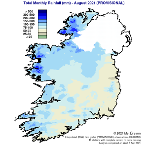
Total Monthly Rainfall (mm) for August 2021 (Provisional)
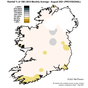
Rainfall % of 1981 – 2010 Monthly Average for August 2021 (Provisional)
Summer 2021 : Warm and relatively dry
Summer 2021 was warm everywhere and relatively dry overall, especially in the South and East. There was widespread heatwaves during July and dry spells record-ed during June and July. June (provisionally the third driest June on record) was a very dry month with the Jetstream staying mostly to the north of the country. This allowed high pressure to stay in control. It was driest, warmest and sunniest in the Midlands, South and East, with the West and North cooler and cloudier as weak Atlantic weather fronts encroached from the west on numerous occasions. After a dry start, July saw Atlantic low-pressure systems take control for most of the first two weeks, which brought widespread heavy and thundery rain at times. During the third and fourth weeks, blocking high-pressure dominated as the Jetstream moved north, allowing a very warm or hot air mass to move up from the south, culminated in heatwave conditions in many places. The end of July saw the Jetstream returning, bringing Atlantic westerlies with widespread rain at times. The Jetstream stayed to the south during the first three weeks of August keep-ing Atlantic low-pressure systems in control. This brought widespread heavy and thundery rain at times, especially towards the end of the first and third weeks. The final third of August saw the Jetstream weaken and move to the north again, allowing blocking high pressure to dominate and bring mostly dry conditions with some pleasant late summer sunshine at times.
The full summer report is available here
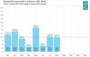
Gridded 2021 rainfall (%) on a monthly basis for Ireland so far