Updated 12.45pm Tuesday 7th March 2023
The uncertainties surrounding the forecast for Thursday the 9th of March are keenly illustrated on the chart below. The image demonstrates the probability of precipitation falling as either drizzle, rain, sleet or snow based on a forecast from Met Éireann’s high-resolution ensemble prediction system, IREPS. The darker the colour, the more certain the forecast is for that precipitation type to fall.
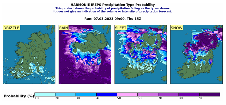
Probability of precipitation falling as either drizzle, rain, sleet or snow at 3pm on Thursday the 9th of March from a model forecast on Tuesday the 7th of March.
The snapshot shown is the forecast for 3pm on Thursday the 9th of March, as of the morning of the 7th of March. Focusing on the “Rain”, “Sleet” and “Snow” panels, the transformation of the precipitation as it moves northwards across the country is evident, with the precipitation almost certain to fall as rain in the somewhat milder air to the south, becoming sleet through north Munster and into the midlands and a very high likelihood of snow in north Leinster and Ulster.
According to Dr. Alan Hally, Forecasting Services Manager at Met Éireann, “Our high-resolution ensemble prediction system is specifically designed to represent the uncertainties related to these types of events. In Ireland, the occurrence of snow is almost always a marginal event, and our forecasters rely heavily on ensemble prediction systems in order to determine the most likely outcome and to decide on appropriate and timely warnings”.
For the most accurate and up to date forecast for your area on the Island of Ireland, go to https://www.met.ie. The latest weather advisories and warnings for Ireland are on the Met Éireann Warnings page.
For information on winter weather preparation, please consult www.winterready.ie.
Issued at 6pm Monday 6th March 2023
Much colder this week as a northerly airflow moves over the country introducing sharp to severe frosts at night and icy patches with some snow in the forecast.
A cold front sinks southward across Ireland on Monday evening (March 6th) introducing a much colder polar maritime airmass. Met Éireann has issued a Yellow Ice warning for tonight (Monday 6th of March) as temperatures drop to freezing countrywide.
According to Forecaster Gerry Murphy “For Monday night temperatures will fall to between -4 to 0 degrees leading to a widespread sharp frost and some icy stretches, especially over the northern half of the country. Further south, outbreaks of rain will turn to sleet or snow for a time overnight in Munster leading to poor visibility and hazardous driving conditions. A cold bright day on Tuesday will be followed by a very cold night on Tuesday night with widespread frost and some icy stretches. Outbreaks of sleet or snow may develop late in the night in Cork and Kerry”.
Airmass for Tuesday 7th March – Thursday the 9th of Marth showing a cold (blue) airmass extending southwards over Ireland.
There is a lot of uncertainty in the forecast from midweek onwards, with some model runs bringing the boundary between the cold polar airmass and the milder tropical airmass northwards over the country, which could bring a spell of snow for a time ahead of the milder air. The extent of this event and its impacts will become more evident by midweek, at which time further warnings will be issued if necessary.
For the most accurate and up to date forecast for your area on the Island of Ireland go to met.ie. The latest weather advisories and warnings for Ireland are on the Met Éireann Warnings page. These services and more are available on our free app – available from the App store for iPhone, and Play store for Android.
For information on winter weather preparation, please consult www.winterready.ie