What is an Ensemble Prediction System?
Weather forecasters use guidance from Numerical Weather Prediction (NWP) mathematical models. Such models require initial conditions such as weather observations and information at the boundaries of the area over which the model is run in order to produce forecasts. These models consists of mathematical equations used to predict the evolution of the state of the atmosphere. Runs of the model are known as deterministic forecasts and offer one solution, or one forecast, based on a set of initial conditions.
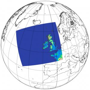
The geographical area over which Met Éireann runs its operational NWP forecasts is highlighted in colour.
On the other hand, ensemble forecasting involves several concurrent runs of an NWP model, each with slightly different, or perturbed, initial conditions. Perturbations are a way of expressing the uncertainty in the initial conditions provided to the model. These uncertainties arise due to a sparsity of weather observations and errors in measurements, and mean that we can never fully know the exact state of the atmosphere at a given moment.
An ensemble system uses a range of slightly different initial conditions with each set of initial conditions leading to a different forecast. These forecasts are known as ensemble members, each of which represents an equally likely outcome or forecast. Ensemble Prediction Systems (EPS) therefore provide a sense of the probability of certain weather conditions, as well as the range of possibilities.
The Met Éireann EPS, called IREPS – Irish Regional Ensemble Prediction System, came into operational use at midday on Monday October 15th 2018 and is the first EPS system run operationally by Met Éireann. The ensemble had been running pre-operationally for several months. The European Centre for Medium Range Weather Forecasting (ECMWF) has been running coarser grid ensemble prediction systems for the past few decades. However, the advantage of IREPS is its very high resolution.
For more general details on EPS see a previous Met Éireann article on the topic which can be found here.
Technical Details
IREPS is an ensemble which uses the HARMONIE-AROME model configuration (version 40h1.1) of the shared ALADIN-HIRLAM NWP system (hereafter HARMONIE-AROME). It consists of 10 ensemble members with 1 control or deterministic member. The control member produces 54-hour forecasts and runs four times daily at 00 Z, 06 Z, 12 Z, and 18 Z. Each of the 10 ensemble members produce 36-hour forecasts and run twice daily at 00 Z and 12 Z. IREPS runs with a horizontal grid spacing of 2.5 km, a spatial extent of 1000 x 900 grid points (see figure above), and 65 vertical levels. Both conventional (observations from weather stations, ships, buoys, balloons and aircraft) and scatterometer (satellite wind data) observations are assimilated or ingested into the model.
The ensemble members are constructed using a combination of boundary condition perturbations and perturbations applied to surface parameters in the model. The boundary condition perturbations follow the Scaled Lagged Average Forecasting (SLAF) technique whereby older boundary conditions valid at the current time are perturbed by a scaling factor which depends on their age with respect to the current time. The surface perturbations are applied to a number of variables within the surface code in the model such as Sea Surface Temperature and soil moisture. These perturbations are intended to account for uncertainty related to energy transfer from the model surface to the planetary boundary layer (usually the lowest kilometer of the atmosphere).
What does output from an EPS look like?
Below is an example of IREPS wind gust forecasts associated with Storm Callum, valid for 09:00 UTC (10:00 local time) on Friday 12th October 2018. Over 50% of the ensemble members indicate gusts of between 120 and 130 km/h in Belmullet in northwest Mayo; the highest recorded gust for this location during Storm Callum was 124 km/hr shortly after 09:00 UTC.
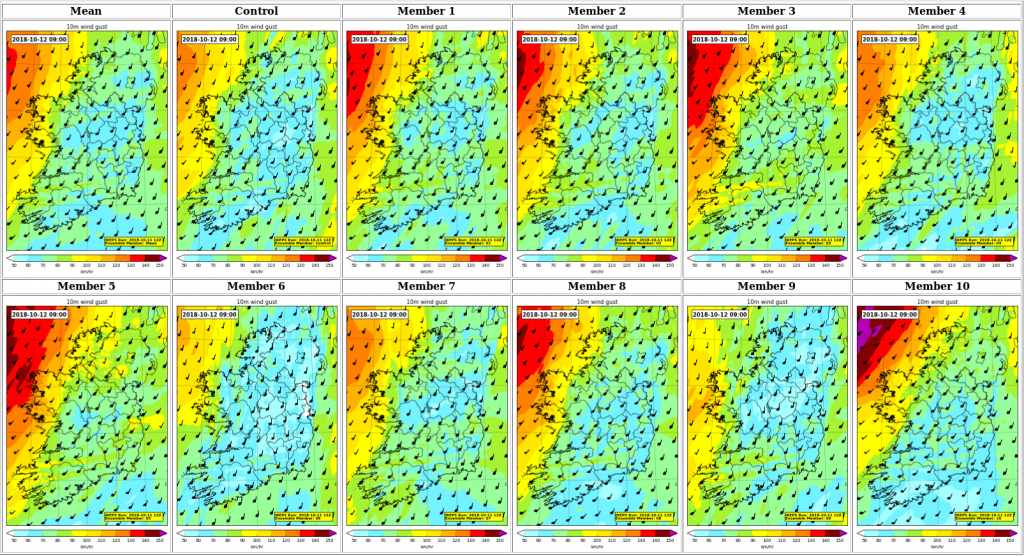
IREPS wind gust forecast valid at 09:00 UTC (10:00 local time) on Friday 12th October 2018 during Storm Callum.
Below you can listen to Dr Rónán Darcy and Dr Alan Hally talking about setting up IREPS and its benefits for weather forecasting.