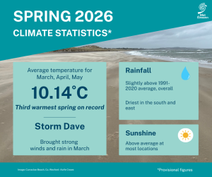
Third warmest Spring on record. Wet in the West, drier in the South and East
Spring 2026 was exceptionally warm, ranking among the warmest Springs in the long-term record, while rainfall was near normal overall. March was mild and relatively wet. April was mild and quite sunny. May was mild and dry with a heat dome bringing record breaking hot conditions towards the end of the season.
Key figures:
- The national mean spring 2026 temperature (using the Island of Ireland dataset*) was 10.14 °C, 1.77 °C above the 1961-1990 LTA and 1.02 °C above the 1991-2020 LTA.
- Spring 2026 is the 3rd warmest spring since 1900.
- Seven of the ten warmest Springs have occurred since 2001. In descending order, these are 2025, 2026, 2024, 2017, 2023, 2007 and 2011.
- The national gridded average rainfall for spring 2026 was around normal with 103 % of the 1991-2020 LTA (257.5 mm) ranking the 32nd wettest spring since 1941.
Spring Climate Statement highlights
Spring 2026 was milder than average. It was wetter than average in the West and drier than average in the South and East. March was mild and relatively wet overall, but drier in the South. Low pressure to the northwest and high pressure to the southeast brought a mobile Atlantic regime for most of the month with winds between southerly and westerly. This led to periods of frontal rain or showers at times, sometimes heavy, but also periods where transient ridges of high pressure brought some dry days with pleasant spring sunshine. April was mild and quite sunny overall. It was wet in the West and dry in the East. Atlantic low pressure dominated the first two thirds of April. Storm Dave, named by the UK Met Office, passed over the northwest of Ireland late on Saturday 4th April and was amongst several unseasonably deep low pressure systems that passed close to the northwest of Ireland during the early part of the month. High pressure to the north took control for the final third of the month and brought much drier and sunnier conditions in an easterly airflow. May was mild and dry overall. The first two thirds of the month were relatively cool with high pressure to the west directing Arctic airmasses over Ireland. A hot tropical continental airmass and an intense area of high pressure, known as a heat dome, brought record high temperatures for May and spring during the final third of the month along with plenty of sunshine.
Rainfall: Above average in the West, North and Midlands, below average in the South and East
The majority of seasonal rainfall totals were above their 1991-2020 Long-Term Average (LTA). Percentage of seasonal rainfall values ranged from 60% (99.4 mm) at Casement Aerodrome, Co Dublin to 127% (305.5 mm) at Athenry, Co Galway. Seasonal rainfall totals ranged from 99.4 mm (60% of its LTA) at Casement Aerodrome, Co Dublin to 373.4 mm (117% of its LTA) at Valentia Observatory, Co Kerry. The highest daily rainfall total was 38.6 mm at Belmullet, Co Mayo on Saturday 4th April. The number of rain days* ranged from 39 days at both Phoenix Park, Co Dublin and Dublin Airport, Co Dublin to 67 days at Newport, Co Mayo. The number of wet days* ranged from 25 days at Phoenix Park, Co Dublin to 53 days at Newport, Co Mayo. The number of very wet days* ranged from 2 days at both Oak Park, Co Carlow and Dublin Airport, Co Dublin to 11 days at Valentia Observatory, Co Kerry.
Climatological dry periods occurred in the East during April and May. Two stations, Phoenix Park and Casement Aerodrome, Co Dublin had absolute droughts* lasting 22 days between April 19th and May 10th, and partial droughts* lasting 32 days between April 11th and May 12th. Two other stations, Dublin Airport and Dunsany, Co Meath had dry spells* lasting 25 and 20 days respectively between April 18th and May 12th. It was the wettest spring for 7 years in parts of the Northwest and the driest spring for 6 years in parts of the East.
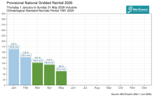
Provisional monthly gridded 2026 rainfall anomalies so far (% of 1991-2020 LTA) together with monthly rainfall totals in millimeters (spring months in green)
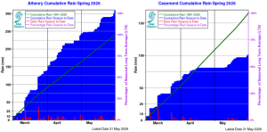
Seasonal cumulative rainfall totals at Athenry, Co GAlway (left) and Casement, Co Dublin (right) in spring 2026, relative to seasonal long term average (highlighting the wet West and dry East contrast).
Temperature: Above average everywhere, warmest in the South and East
All mean air temperatures across the country were above their LTA for the season. Deviations from mean air temperature ranged from +0.5 °C (9.9 °C) at Belmullet, Co Mayo to +1.3 °C at both Dublin Airport, Co Dublin (9.7 °C mean temperature) (its 2nd warmest Spring on record behind 1990 (record length 84 years)) and Phoenix Park, Co Dublin (10.3 °C mean temperature). Mean temperatures for the season ranged from 8.9 °C (1.0 °C above its LTA) at Knock Airport, Co Mayo to 10.7 °C at both Sherkin Island, Co Cork and Shannon Airport, Co Clare (0.9 °C above their LTA). The season’s highest temperature at a synoptic station was reported at Shannon Airport, Co Clare on Tuesday 26th May with a temperature of 30.6 °C (the highest daily maximum air temperature for spring ever recorded at a synoptic station, subject to verification). The season’s lowest air minimum was recorded on Friday 6th March at Markree, Co Sligo with -3.8 °C while the lowest grass minimum was -8.6 °C reported at Dublin Airport, Co Dublin on Tuesday 3rd March.
All stations reported ground frost during the season. The number of days with ground frost ranged from 3 days at Cork Airport to 45 days at Phoenix Park, Co Dublin. More than half of stations reported air frost. The number of days with air frost ranged from zero days at Mace Head, Co Galway to 13 days at both Markree, Co Sligo and Mount Dillon, Co Roscommon. Eighteen synoptic stations set new station records for spring maximum air temperatures between Sunday 24th May and Wednesday 27th May. Two stations, Oak Park, Co Carlow with a mean temperature of 10.2 °(length 19 years) and Dunsany, Co Meath with a mean temperature of 9.5 °C (length 33 years) had their 3rd warmest spring on record.

Provisional top 10 warmest springs for Ireland (1900-2026 incl.). Island of Ireland Long-Term Temperature Series (°C).
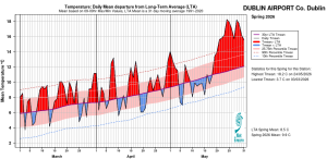
Dublin Airport, Co Dublin Temperature: Daily mean departure from LTA for spring 2026 based on 09-09hr Max/Min values
Sunshine: Sunniest in the East and North
Nearly all available sunshine totals were above their LTA for the season. Percentage of sunshine values ranged from 106% (484.9 hours) at Shannon Airport, Co Clare to 122% (the season’s highest sunshine total of 553.4 hours) at Casement Aerodrome, Co Dublin. Seasonal sunshine totals were lowest at Valentia Observatory, Co Kerry with 411.8 hours (No LTA comparison*). The highest number of daily sunshine hours recorded this season was 15.2 hours at Johnstown Castle, Co Wexford on Tuesday 26th May. The number of dull days* ranged from 5 days at Casement Aerodrome, Co Dublin to 21 days at Valentia Observatory, Co Kerry.
Wind: Storm force winds reported during storm Dave
Seasonal mean wind speeds ranged from 6.4 knots (11.9 km/h) at Moore Park, Co Cork to 15.1 knots (28.0 km/h) at Mace Head, Co Galway. Gales were reported on numerous days with strong gales reported on 8 days during the season. Strong gales were reported on 11th, 12th, 13th, 15th, 24th and 25th of March, 4th April during storm Dave and 11th April. Storm force winds were reported on Wednesday 25th March at Malin Head, Co Donegal and on Saturday 4th April at Roches Point, Co Cork during storm Dave. The number of days with gales ranged from zero days at a few stations to 15 days at Mace Head, Co Galway. The number of days with up to strong gales ranged from zero days at most stations to 6 days at Mace Head, Co Galway.
The season’s highest 10-minute mean wind speed was reported at both Roches Point, Co Cork on Saturday 4th April during storm Dave and at Malin Head, Co Donegal on Wednesday 25th March with 48 knots (89 km/h). The highest gust was 62 knots (115 km/h) reported at Malin Head, Co Donegal on Wednesday 25th March.
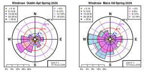
Dublin Airport, Co Dublin and Mace Head, Co Galway: Wind roses for spring 2026.
PDF report and charts are available here (choose Spring on drop down menu for month).
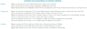
Spring 2026 extreme values at synoptic stations.
Notes to Editor:
- *Issued by Met Éireann on Thursday 4th June 2026. This report is based on available preliminary data from 25 principal weather stations operated by Met Éireann. Synoptic station data is midnight to midnight UTC. Long-Term Averages (LTAs) and “average” refer to the period 1991-2020 unless stated.
- A rain day is a day on which 0.2 mm or more of rainfall is measured. A wet day is a day with 1.0 mm or more of rainfall. A dull day is a day with less than 0.5 hours of sunshine. A very wet day is a day with 10.0 mm or more of rainfall.
- Climatological dry periods – An absolute drought is a period of 15 or more consecutive days to none of which is credited 0.2 mm or more of precipitation. A partial drought is a period of at least 29 consecutive days, the mean daily rainfall of which does not exceed 0.2 mm. A dry spell is a period of 15 or more consecutive days to none of which is credited 1.0 mm or more of precipitation (i.e. daily tot < 1.0 mm).
- A heatwave occurs where there are 5 consecutive days or more with maximum temperature over 25°C (that is, a daily maximum screen air temperature > 25° C).
- The ‘Island of Ireland’ dataset is 125 years long and runs between 1900 and 2023. For this dataset the long term averages from the 1961-1990 reference period are used for comparison as is standard for long-term climate change assessments.
- Sunshine data is from the Autosol Network. LTAs for these sites are currently not used for comparison purposes.
- For more information or interview opportunities with a Met Éireann spokesperson, please contact us at enq@met.ie.