Very mild, sunny and wet with one named storm
September 2023 brought heatwaves, heavy rainfall and the first named storm of the season, storm Agnes. The first third of the month saw Ireland situated between blocking high pressure over mainland Europe and slow moving low pressure to the west and southwest. This brought one of the warmest spells of the year as a hot tropical-continental air mass moved over the country from the south-southeast, with record maximum and minimum temperatures for September at many stations. Scattered thunderstorms broke out between the 7th and 10th before Atlantic weather fronts brought a change of air mass on the 11th. The second third of the month was cooler with rain or showers on most days as Atlantic low pressure systems gradually became more dominant, with widespread and heavy rain on the 15th and 19th. Strong winds were also a feature between the 18th and 20th with low pressure to the north of Ireland. The final third of the month was often windy with Atlantic low pressure systems in control. An area of low pressure, containing remnants of ex-hurricane Nigel, brought heavy frontal rain to the Northwest of the country on the 24th. A deep Atlantic low pressure system storm Agnes, named by the Met Office (UK), moved across the country from southwest to northeast on the 27th and brought further widespread heavy rain and the windiest period of the month.
Rainfall: Above average nearly everywhere, wettest in the East and South
The majority of monthly rainfall totals were above their 1981-2010 Long-Term Average (LTA). Percentage of monthly rainfall values ranged from 76% (the month’s lowest monthly rainfall total of 77.2 mm) at Belmullet, Co Mayo to 225% (monthly rainfall total of 134.1 mm) at Dublin Airport, Co Dublin (its wettest September since 1976). Monthly rainfall totals were as much as 189.3 mm (151% of its LTA) at Valentia Observatory, Co Kerry. The highest daily rainfall total was 57.9 mm at Mace Head, Co Galway on Sunday 24th. The number of rain days ranged from 16 days at Roche’s Point, Co Cork to 24 days at both Sherkin Island, Co Cork and Knock Airport, Co Mayo. The number of wet days* ranged from 12 days at Roche’s Point, Co Cork to 18 days at both Malin Head, Co Donegal and Johnstown Castle, Co Wexford. The number of very wet days* ranged from 3 days at a few stations to 8 days at Valentia Observatory, Co Kerry. Johnstown Castle, Co Wexford had its wettest September since 1974 with 178.4 mm (203% of its LTA). Both Roches Point, Co Cork with 145.9 mm (172% of its LTA) and Cork Airport with 171.4 mm (181% of its LTA) had their wettest September since 2006. Both Shannon Airport, Co Clare with 113.8 mm (151% of its LTA) and Mullingar, Co Westmeath with 132.9 mm (170% of its LTA) had their wettest September since 2010.
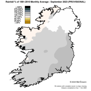
Rainfall % of 1981 – 2010 Monthly Average for September 2023 (Provisional)
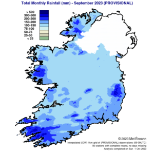
Total Monthly Rainfall (mm) for September 2023 (Provisional)
Temperature: Above average everywhere, heatwaves and September station records in places
All mean air temperatures across the country were above their LTA for the month. Deviations from mean air temperature ranged from 1.0 °C (13.8 °C mean temperature) at Markree, Co Sligo to 2.1 °C (15.2 °C mean temperature) at Phoenix Park, Co Dublin. Mean temperatures for the month ranged from 13.6 °C (1.6 °C above its LTA) at Knock Airport, Co Mayo to 15.7 °C (1.5 °C above its LTA) at Shannon Airport, Co Clare. The month’s highest temperature was reported at Oak Park, Co Carlow on Friday 8th with a temperature of 28.5 °C (its highest September temperature on record). The month’s lowest air minimum was recorded on Thursday 21st at Markree, Co Sligo with 2.5 °C while the lowest grass minimum was -1.3 °C reported at Cork Airport on Saturday 23rd. There was no air frost reported this month. Less than half of stations reported ground frost. The number of days with ground frost ranged from zero days at most stations to 1 day at a few stations. Heatwaves* were reported at four stations between Monday 4th and Friday 8th lasting between 5 and 6 days. These were at Mount Dillon, Co Roscommon, Shannon Airport, Co Clare (5 days), Oak Park, Co Carlow and Gurteen, Co Tipperary (6 days). Twenty-four stations reported their highest temperature of the year. Fourteen stations broke their September maximum temperature record and 10 stations broke their September highest minimum temperature record.
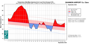
Shannon Airport, Co Clare temperature: Daily mean departure from LTA for September 2023
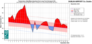
Dublin Airport, Co Dublin temperature: Daily mean departure from LTA for September 2023
Sunshine: Above average everywhere
All available sunshine totals were above their LTA. Percentage of monthly sunshine values ranged from 114% (monthly sunshine total of 135.9 hours) at Shannon Airport, Co Clare to 118% (monthly sunshine total of 146.3 hours) at Casement Aerodrome, Co Dublin. Monthly sunshine totals ranged from 121.3 hours (No LTA comparison*) at Belmullet, Co Mayo to 154.9 hours (No LTA comparison*) at Johnstown Castle, Co Wexford. The highest number of daily sunshine hours recorded this month was 12.6 hours at Malin Head, Co Donegal on Monday 4th. The number of dull days* ranged from 6 days at Casement Aerodrome, Co Dublin to 10 days at Cork Airport, Co Cork.
Wind: Strong gales reported during storm Agnes
Monthly mean wind speeds ranged from 5.4 knots (10.0 km/h) at Moore Park, Co Cork to 13.8 knots (25.6 km/h) at Malin Head, Co Donegal. Gales were reported on the 19th, 20th, 24th, 27th and 28th with up to strong gale winds reported on Wednesday 27th during storm Agnes. The number of days with gales ranged from zero days at a few stations to 4 days at Roche’s Point, Co Cork. The number of days with up to strong gales ranged from zero at most stations to 1 day at both Sherkin Island, Co Cork and Roche’s Point, Co Cork. Both the month’s highest gust and 10-minute mean wind speed were reported on Wednesday 27th during storm Agnes. The highest gust was 63 knots (117 km/h) reported at Sherkin Island, Co Cork (its highest September gust on record (length 18 years)) while the month’s highest 10-minute mean wind speed was 46 knots (85 km/h) at Roche’s Point, Co Cork. Serkin Island, Co Cork also had its highest September mean wind speed on record with a mean wind of 45 knots (83 km/h).
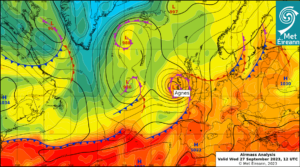
Airmass Analysis chart 12 UTC 27 September 2023 with storm Agnes
The full report is available at https://www.met.ie/climate/past-weather-statements
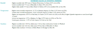
September 2023 extreme values at synoptic stations
Recent Septembers in Ireland:
- 2016: The majority of stations reported above Long-Term Average (LTA) rainfall values. All stations reported mean air temperatures on or above their LTA. All sunshine values were below average while gales were reported.
- 2017: Above-average monthly rainfall totals at most stations. All mean temperatures were on or below their LTA. Over half of monthly sunshine totals were on or above average and strong gales were reported.
- 2018: The majority of monthly rainfall totals across the country were below their LTA. All mean
temperatures were below their LTA. Sunshine totals were variable and two named storms, storm Ali and Bronagh, passed close to or across Ireland bringing storm-force winds and strong gales. - 2019: The majority of monthly rainfall totals were above their LTA. Mean air temperatures were slightly above average in most places. Nearly all sunshine totals were above average, and gales were reported.
- 2020: Nearly all rainfall totals were below their LTA. Mean air temperatures were near or slightly above their LTA. Sunshine totals were above average everywhere and strong gales were reported.
- 2021: The majority of monthly rainfall totals were below their LTA. All mean air temperatures
were above average with records in places, while sunshine totals were below. Gales were reported. - 2022: The majority of monthly rainfall totals were above their LTA. Nearly all mean air temperatures were above. Sunshine totals varied and strong gales were reported.
*Issued by Met Éireann on Tuesday 3rd October 2023. This report is based on available preliminary data from 25 principal weather stations operated by Met Éireann. Synoptic station data is midnight to midnight UTC. Long-Term Averages (LTAs) and “average” refer to the period 1981-2010. A wet day is a day with 1.0 mm or more of rainfall. A dull day is a day with less than 0.5 hours of sunshine. A very wet day is a day with 10.0 mm or more of rainfall. Climatological dry periods – An absolute drought is a period of 15 or more consecutive days to none of which is credited 0.2 mm or more of precipitation. A partial drought is a period of at least 29 consecutive days, the mean daily rainfall of which does not exceed 0.2 mm. A dry spell is a period of 15 or more consecutive days to none of which is credited 1.0 mm or more of precipitation (i.e. daily tot < 1.0 mm). A heatwave occurs where there are 5 consecutive days or more with maximum temperature over 25°C (that is, a daily maximum screen air temperature > 25° C). *Sunshine data is from the Autosol Network. LTAs for these sites are currently not used for comparison purposes. For more information, contact Met Éireann at 01-8064200 or e-mail: enq@met.ie