Wet overall. Very mild first half, cooler second half
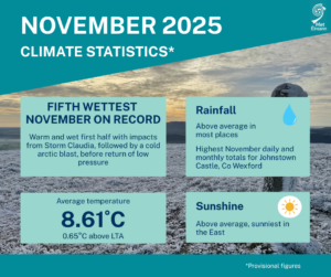
November 2025 was the fifth wettest November in 85 years of records for Ireland, and another warmer than average month, with the impacts of Storm Claudia and a short spell of frost and wintry showers also felt across the period, according to the latest Climate Statement from Met Éireann.
Key Figures:
- The national mean air temperature of 8.61°C (using the Island of Ireland dataset*) placed November 2025 21st warmest in 126 years.
- 8.61 °C is 1.54 °C above 1961-1990 LTA and 0.65 °C above the most recent 1991-2020 LTA.
- Of the top ten warmest Novembers, five have occurred since 2001 (highest first 2011, 2015, 2022, 2002 and 2024). None of the top ten coolest Novembers have occurred since 2001.
- The national gridded average rainfall of 189 mm ranked 5th wettest in 85 years and 136% of its 1991-2020 LTA.
- The wettest November was in 2009 (278.8 mm) and driest was 1942 (33.2 mm).
- Of the top ten wettest Novembers, four have occurred since 2001 (highest first 2009, 2015, 2002 and 2025).
November Climate Statement highlights
The first half of the month was very mild, while the second half was cooler. The mobile Atlantic dominated theme, from the end of October, continued for the first two weeks of November, with very mild and often wet conditions prevailing.
Storm Claudia, named by the Spanish Meteorological Agency (AEMET), stalled to the southwest of Ireland between Tuesday 11th and Sunday 16th, steering a warm tropical maritime airmass, along with numerous active weather fronts and pulses of heavy rain, northwards across the country. On Friday 14th and Saturday 15th, as high pressure to the north of Ireland began to sink south, a cold Arctic airmass undercut the warm tropical maritime airmass situated over Ireland and the UK, creating extra lift along a stalled frontal zone over the south of the country and tightened the isobars. This brought intense rainfall, especially to the Southeast, and very strong northeasterly winds.
The rest of the third week was drier and colder as high pressure to the northwest took control and steered a cold Arctic airmass south over the country. This brought several very cold days with widespread frosts at night along with wintry showers, especially for the West and Northwest.
Atlantic weather fronts encroached from the west late on Friday 21st bringing a spell of rain and milder temperatures. The remainder of the month saw Atlantic low pressure to the north bringing periods of rain or showers at times, interspersed with high pressure to the south bringing brief periods of clearer, cooler and drier conditions.
Rainfall: Above average in most places, wettest in the Midlands, South and East
November 2025 rainfall totals were above their 1991-2020 Long-Term Average (LTA) at the majority of stations. Percentage of monthly rainfall values ranged from 89% (116.4 mm) at Markree, Co Sligo to 206% (the month’s highest monthly rainfall total of 237.2 mm) at Johnstown Castle, Co Wexford (its wettest November on record (length 84 years)). Monthly rainfall totals for the month were lowest at Oak Park, Co Carlow with 110.1 mm (119% of its LTA). The month’s wettest day was also recorded at Johnstown Castle, Co Wexford with 66.9 mm on Friday 14th, associated with storm Claudia (its highest daily fall for November on record).
The number of rain days* ranged from 23 days at Phoenix Park, Co Dublin to 28 days at several stations. The number of wet days* ranged from 17 days at Phoenix Park, Co Dublin to 27 days at Claremorris, Co Mayo. The number of very wet days* ranged from 2 days at Markree, Co Sligo to 9 days at Valentia Observatory, Co Kerry. It was the wettest November since 2009 at Cork Airport and the wettest since 2015 at six stations.
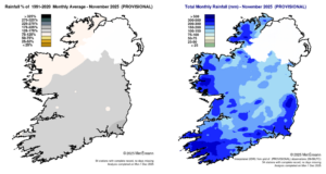
Rainfall % of 1991 – 2020 Monthly Average for November 2025 (Provisional) Total Monthly Rainfall (mm) for November 2025 (Provisional)
Temperature: Above average everywhere, warmest in the South and East
All mean air temperatures across the country were above their LTA for the month. Deviations from mean air temperature ranged from +0.3 °C at Belmullet, Co Mayo, Finner, Co Donegal and Newport, Co Mayo (9.1 °C, 8.3 °C, 8.8 °C mean temperatures respectively) to +1.0 °C at Casement Aerodrome, Co Dublin and Oak Park, Co Carlow (8.3 °C , 8.4 °C mean temperature respectively). Mean temperatures for the month ranged from 7.0 °C (0.6 °C above its LTA) at Knock Airport, Co Mayo to 10.3 °C (0.7 °C above its LTA) at Sherkin Island, Co Cork.
The month’s lowest temperature was recorded on Friday 21st with an air minimum of -4.5 °C reported at Mount Dillon, Co Roscommon and the lowest grass minimum of -8.6 °C reported at Markree, Co Sligo. The highest maximum temperature of 17.5 °C was reported on Wednesday 5th at Dunsany, Co Meath and on Thursday 6th at Phoenix Park, Co Dublin.
All stations reported ground frost during the month. The number of days with ground frost ranged from 2 days at Knock Airport, Co Mayo to 18 days at Phoenix Park, Co Dublin. More than half of stations reported air frost. The number of days with air frost ranged from zero days at six coastal stations to 8 days at Moore Park, Co Cork.
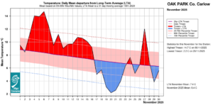
Oak Park, Co Carlow Temperature: Daily mean departure from LTA for November 2025 based on 09-09hr Max/Min values.
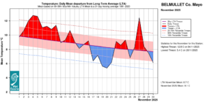
Belmullet, Co Mayo Temperature: Daily mean departure from LTA for November 2025 based on 09-09hr Max/Min values.
Sunshine: Above average, sunniest in the East
All available sunshine totals were above their LTA. Percentage of monthly sunshine values ranged from 125% (84.2 hours) at Casement Aerodrome, Co Dublin to 127% (79.0 hours) at Shannon Airport, Co Clare. Monthly sunshine totals ranged from 48.4 hours (No LTA comparison*) at Belmullet, Co Mayo to 91.7 hours (No LTA comparison*) at Dublin Airport, Co Dublin.
The highest number of daily sunshine hours recorded this month was 8.2 hours at Cork Airport, Co Cork on Monday 17th. The number of dull days* ranged from 8 days at Shannon Airport, Co Clare to 13 days at both Valentia Observatory, Co Kerry and Belmullet, Co Mayo.
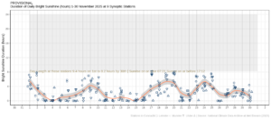
Hours of Bright Sunshine observed at nine stations for each day of the month of November 2025, grouped by province relative to the highest number of hours possible by end of month (shaded box).
Wind: Strong gales reported
Monthly mean wind speeds ranged from 5.4 knots (10.0 km/h) at Moore Park, Co Cork to 17.6 knots (32.6 km/h) at Malin Head, Co Donegal. Gales were reported on 11 days during the month with strong gale force winds reported on Sunday 23rd at Mace Head, Co Galway and Thursday 27th at both Mace Head, Co Galway and Malin Head, Co Donegal. The number of days with gales ranged from zero days at a few stations to 8 days at Malin Head, Co Donegal. The number of days with up to strong gales ranged from zero days at most stations to 2 days at Mace Head, Co Galway and 1 day at Malin Head, Co Donegal. Both the month’s highest gust and 10-minute mean wind speed was reported at Malin Head, Co Donegal on Thursday 27th. The highest gust was 62 knots (115 km/h) while the month’s highest 10-minute mean wind speed was 45 knots (83 km/h).
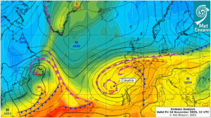
Airmass Analysis chart 12 UTC 14 November 2025: Storm Claudia to the southwest steered numerous active weather fronts across the country from the south.
Full PDF report and charts are available here
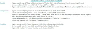
Extreme values for November 2025 at synoptic stations.
Notes to Editor:
- *Issued by Met Éireann on Tuesday 2nd December 2025. This report is based on available preliminary data from 25 principal weather stations operated by Met Éireann. Synoptic station data is midnight to midnight UTC. Long-Term Averages (LTAs) and “average” refer to the period 1991-2020 unless stated.
- A rain day is a day on which 0.2 mm or more of rainfall is measured. A wet day is a day with 1.0 mm or more of rainfall. A dull day is a day with less than 0.5 hours of sunshine. A very wet day is a day with 10.0 mm or more of rainfall.
- Climatological dry periods – An absolute drought is a period of 15 or more consecutive days to none of which is credited 0.2 mm or more of precipitation. A partial drought is a period of at least 29 consecutive days, the mean daily rainfall of which does not exceed 0.2 mm. A dry spell is a period of 15 or more consecutive days to none of which is credited 1.0 mm or more of precipitation (i.e. daily tot < 1.0 mm).
- A heatwave occurs where there are 5 consecutive days or more with maximum temperature over 25°C (that is, a daily maximum screen air temperature > 25° C).
- The ‘Island of Ireland’ dataset is 125 years long and runs between 1900 and 2023. For this dataset the long term averages from the 1961-1990 reference period are used for comparison as is standard for long-term climate change assessments.
- Sunshine data is from the Autosol Network. LTAs for these sites are currently not used for comparison purposes.
- For more information or interview opportunities with a Met Éireann spokesperson, please contact us at enq@met.ie.