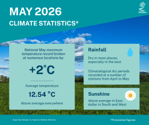
National May Maximum Temperature Record Broken by more than 2 °C
Last month saw the national May maximum temperature record exceeded by more than 2 °C, according to the latest climate statement issued by Met Éireann. An intense area of high pressure combined with an unseasonably hot tropical airmass brought exceptionally high temperatures between Monday 25th and Wednesday 27th. The previous May national record high temperature of 28.4 °C set in Ardfert, co Kerry in 1997, was surpassed at a series of locations (climate stations) on Monday, May 25th, before a greater number of climate stations reached temperatures in excess of 30.6 °C on Tuesday, May 26th.
- Abbeyfeale Co Limerick with 30.9 °C
- Clonmel, Co Tipperary with 30.9 °C
- Castleisland, Co Kerry with 30.8 °C
- Durrow, Co Laois with 30.8 °C
- Kilkenny (Greenshill), Co Kilkenny with 30.8 °C
- Killarney (Muckross House), Co Kerry with 30.7 °C
- Fethard (Parsonshill), Co Tipperary with 30.7 °C
All stations, synoptic and climate, that provisional broke the May record will now undergo rigorous investigation to determine the new Irish air temperature record for May.
Key monthly figures:
- The national mean May temperature was 12.54 °C, making it the 7th warmest May since 1900.
- 12.54 °C is 1.99 °C above the 1961-1990 LTA and 1.21 °C above the 1991-2020 LTA.
- Eight of the ten warmest Mays have occurred since 2001, while none of the ten coolest Mays occurred recently.
- May 2026 was drier than normal with 79 % of the 1991-2020 LTA (62.7 mm) and is ranked 31st driest May since 1941.
- The highest daily rainfall total was 21.1 mm at Mount Dillon, Co Roscommon on Tuesday 19th.
May Climate Statement highlights.
May 2026 was mild overall. A relatively cool first two thirds was followed by a very warm final third. It was dry in most places, especially in the East. The first week began with low pressure to the southwest bringing scattered outbreaks of rain or showers interspersed with dry periods. Blocking high pressure to the west over the mid-Atlantic introduced a cooler Arctic airmass over the country from the north on Monday 4th. The following two weeks saw high pressure to the west steer further Arctic airmasses over the country from the north, which kept it cool. Rain or showers also moved down from the northwest at times later in the period. On Monday 18th, Atlantic low pressure brought active frontal rain across the country from the southwest introducing a milder Atlantic airmass. Low pressure stayed close by up to Thursday 21st bringing further rain or showers before high pressure to the southeast began to push north over Ireland.
The third week was dominated by an intense area of high pressure in the upper and lower levels of the atmosphere that covered most of western and central Europe, including Ireland. An unseasonably hot tropical continental airmass also pushed north over Ireland on Sunday 24th. This resulted in exceptionally high temperatures for May between Monday 25th and Wednesday 27th. Thunderstorms broke out in the South late on Wednesday 27th before a somewhat cooler Atlantic air broke through for the final few days of the month bringing a return to frontal rain or showers interspersed with dry periods.
Rainfall: Dry in most places, especially in the East
Nearly all rainfall totals were below their 1991-2020 Long-Term Average (LTA) for the month. Percentage of monthly rainfall values ranged from 34% (the month’s lowest monthly rainfall total of 19.8 mm) at Casement Aerodrome, Co Dublin to 111% (72.7 mm) at Ballyhaise, Co Cavan. Monthly rainfall totals were as much as 81.0 mm (86% of its LTA) at Valentia Observatory, Co Kerry. The highest daily rainfall total was 21.1 mm at Mount Dillon, Co Roscommon on Tuesday 19th. The number of rain days* ranged from 11 days at Phoenix Park, Co Dublin to 22 days at both Malin Head, Co Donegal and Finner, Co Donegal. The number of wet days* ranged from 7 days at Oak Park, Co Carlow to 16 days at both Markree, Co Sligo and Finner, Co Donegal. The number of very wet days* ranged from zero days at Phoenix Park, Co Dublin to 3 days at both Ballyhaise, Co Cavan and Sherkin Island, Co Cork. Climatological dry periods continued from April up to the Tuesday 12th May in the East. Two stations, Phoenix Park and Casement Aerodrome, Co Dublin had absolute droughts* lasting 22 days between April 19th and May 10th, and partial droughts* lasting 32 days between April 11th and May 12th. Two other stations, Dublin Airport and Dunsany, Co Meath had dry spells* lasting 25 and 20 days respectively between April 18th and May 12th.
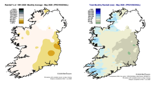
Rainfall % of 1991 – 2020 Monthly Average for May 2026 (Provisional). Total Monthly Rainfall (mm) for May 2026 (Provisional).
Temperature: Above average everywhere, record high May maximum air temperatures at 18 stations
All mean air temperatures across the country were above their LTA for the month. Deviations from mean air temperature ranged from +0.4 °C (12.4 °C mean temperature) at Newport, Co Mayo to +1.9 °C (12.6 °C mean temperature) at Dublin Airport, Co Dublin. Mean temperatures for the month ranged from 11.3 °C at both Malin Head, Co Donegal and Knock Airport, Co Mayo (0.8 °C and 1.1 °C above their LTA respectively) to 13.4 °C (1.2 °C above its LTA) at Shannon Airport, Co Clare. The month’s highest temperature at a synoptic station was reported at Shannon Airport, Co Clare on Tuesday 26th with a temperature of 30.6 °C (the highest daily maximum air temperature for May ever recorded at a synoptic station (this value and other similar values at regional climate stations are under review to determine the new national May maximum air temperature record)).
The month’s lowest air and grass minimum were recorded at Mount Dillon, Co Roscommon with the lowest air temperature reported on Wednesday 6th with -1.3 °C while the lowest grass minimum was -7.5 °C reported on Sunday 10th. More than half of stations reported ground frost. The number of days with ground frost ranged from zero days at a few stations to 10 days at Phoenix Park, Co Dublin. Less than half of stations reported air frost. The number of days with air frost ranged from zero days at most stations to 2 days at both Markree, Co Sligo and Mount Dillon, Co Roscommon. Eighteen stations set new station records for May maximum air temperatures between Sunday 24th and Wednesday 27th.
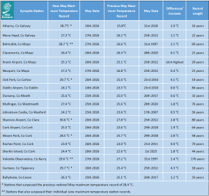
Synoptic (primary) stations new May maximum temperature records compared to previous station records. 7 synoptic stations also broke the previous National May maximum temperature record.
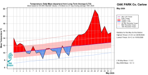
Oak Park, Co Carlow. Temperature: Daily mean departure from LTA for May 2026 based on 09-09hr Max/Min values.
Sunshine: Above average in the East, duller in the South and West
Percentage of LTA sunshine values were variable (where available) across the country. Percentage of monthly sunshine values ranged from 96% (177.0 hours) at Shannon Airport, Co Clare to 108 % (the month’s highest monthly sunshine total of 207.0 hours) at Casement Aerodrome, Co Dublin. The month’s lowest monthly sunshine total was 150.3 hours at Cork Airport, Co Cork (No LTA comparison*). The highest number of daily sunshine hours recorded this month was 15.2 hours at Johnstown Castle, Co Wexford on Tuesday 26th. The number of dull days* ranged from 2 days at Malin Head, Co Donegal to 5 days at both Valentia Observatory, Co Kerry and Cork Airport.
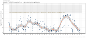
Hours of Bright Sunshine observed at nine stations for each day of the month of May 2026, grouped by province relative to the highest number of hours possible by end of month (shaded box).
Wind: Gales reported at one station
Monthly mean wind speeds ranged from 5.4 knots (10.0 km/h) at Ballyhaise, Co Cavan to 12.6 knots (23.3 km/h) at Mace Head, Co Galway. Gales were reported on Wednesday 13th at one station. The number of days with gale force winds ranged from zero days at most stations to 1 day at Roches Point, Co Cork. There were no strong gales or storms reported this month. The month’s highest gust was reported at both Finner, Co Donegal on Tuesday 12th and at Malin Head, Co Donegal on Wednesday 13th with 47 knots (87 km/h). The highest 10-minute wind speed was 35 knots (65 km/h) reported at Roches Point, Co Cork on Wednesday 13th.
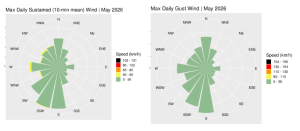
Wind roses for May 2026, sustained 10-min mean and gust.
Full PDF report and charts are available here
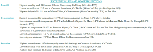
Extreme values for May 2026 at synoptic stations.
Notes to Editor:
- *Issued by Met Éireann on Wednesday 3rd June 2026. This report is based on available preliminary data from 25 principal weather stations operated by Met Éireann. Synoptic station data is midnight to midnight UTC. Long-Term Averages (LTAs) and “average” refer to the period 1991-2020 unless stated.
- A rain day is a day on which 0.2 mm or more of rainfall is measured. A wet day is a day with 1.0 mm or more of rainfall. A dull day is a day with less than 0.5 hours of sunshine. A very wet day is a day with 10.0 mm or more of rainfall.
- Climatological dry periods – An absolute drought is a period of 15 or more consecutive days to none of which is credited 0.2 mm or more of precipitation. A partial drought is a period of at least 29 consecutive days, the mean daily rainfall of which does not exceed 0.2 mm. A dry spell is a period of 15 or more consecutive days to none of which is credited 1.0 mm or more of precipitation (i.e. daily tot < 1.0 mm).
- A heatwave occurs where there are 5 consecutive days or more with maximum temperature over 25°C (that is, a daily maximum screen air temperature > 25° C).
- The ‘Island of Ireland’ dataset is 125 years long and runs between 1900 and 2023. For this dataset the long term averages from the 1961-1990 reference period are used for comparison as is standard for long-term climate change assessments.
- Sunshine data is from the Autosol Network. LTAs for these sites are currently not used for comparison purposes.
- For more information or interview opportunities with a Met Éireann spokesperson, please contact us at enq@met.ie.