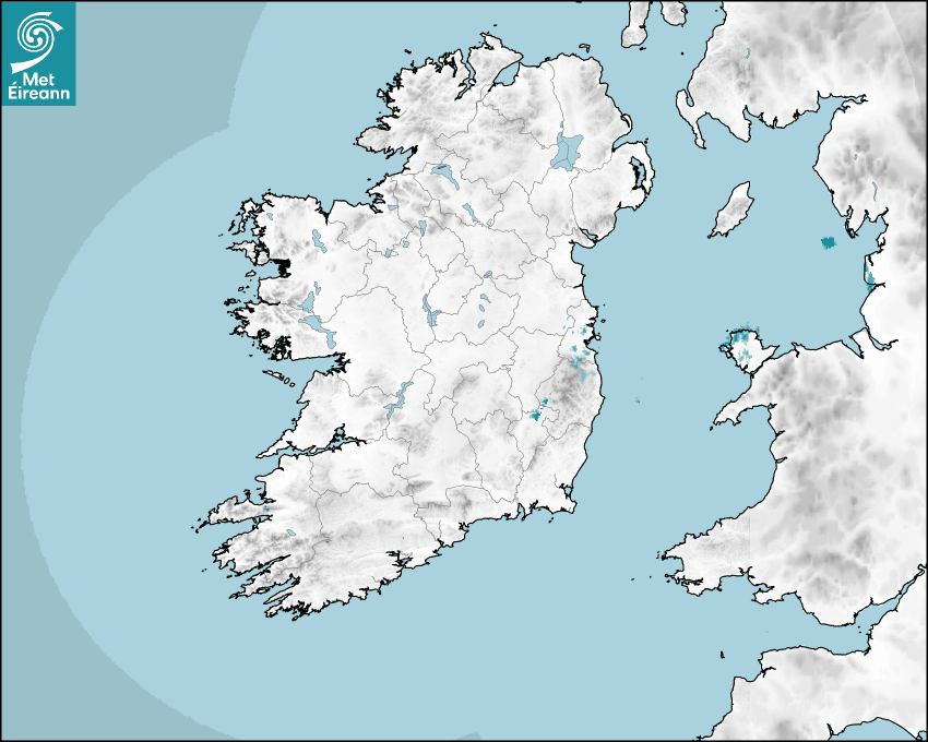

Latest Rainfall Radar showing live precipitation and the last 90 minutes precipitation over Ireland, updated every 5 minutes. Precipitation can be rain, hail or snow. Accumulations can refer to rainfall only.
Lightning strikes, when they occur, are displayed as a cross. Initially, they are red but change to orange and then yellow after a period, then disappear © Met Office ATDNet.
Ground Clutter may appear (South Co. Dublin), bright bands and spokes may also be present in images. They are artefacts (false echoes) of rainfall radar systems and should be ignored. Further information on Radar here
Met Éireann forecasters manually produce the weather icons for midday and midnight to reflect the predicted major weather type for these times.
The rainfall forecast is direct model output from Numerical Weather Prediction models but is a guideline only. Rain refers to precipitation, which can be rain, sleet or snow. It forecasts how much rain will fall (in mm) hourly during the previous hour (accumulations), then in 3 hourly and finally 6 hourly accumulations up to 7 days. This service is based on data and products of the HARMONIE-AROME and the European Centre for Medium-range Weather Forecasts (ECMWF) models.
The wind is direct model output from Numerical Weather Prediction models but is a guideline only. It forecasts the strength of the wind (in knots and km/h) at 10m for the top of each hour, in hourly, then 3 hourly and finally 6 hourly intervals up to 7 days. The wind arrow tip points in the direction the wind is blowing and the tail length indicates wind strength. However, in the text forecast below, it is described as where it is blowing from. This service is based on data and products of the HARMONIE-AROME and the European Centre for Medium-range Weather Forecasts (ECMWF) models.
The temperature is direct model output from Numerical Weather Prediction models but is a guideline only. It forecasts air temperature on land and over sea in °C for the top of each hour, 3 hourly and finally 6 hourly intervals up to 7 days. Minus zero (-0) indicates values between 0 to -0.5°C. This service is based on data and products of the HARMONIE-AROME and the European Centre for Medium-range Weather Forecasts (ECMWF) models.
The Mean Sea Level Pressure (MSLP) is direct model output from Numerical Weather Prediction models but is a guideline only. It forecasts the MSLP in hecto Pascals (hPa) for the top of that hour initially in 3 hourly intervals, then 6 hourly. This service is based on data and products of the HARMONIE-AROME and the European Centre for Medium-range Weather Forecasts (ECMWF) models.
National Forecast
25 May 2026 08:30
Today
Warm and dry today with long spells of sunshine. While mist and fog patches will continue to clear this morning, some sea fog or low cloud is possible through the day, especially along western and northern coasts. Highest temperatures of 23 to 28 degrees generally, warmest in Leinster and Munster, but a little cooler near western and northern coasts. All with light variable breezes.
Tonight
Dry and mild tonight with long clear spells for most, a bit cloudier in the north and west. Some mist and fog patches will develop too. Temperatures will not fall below 10 to 15 degrees in light northerly or variable breezes.
Tomorrow
Warm or very warm tomorrow. Mist and fog patches will clear early on to leave a dry day with long spells of sunshine and just the chance of an isolated shower. Highest temperatures will generally range between 20 and 28 degrees, lowest in Ulster, especially near coasts where it will be cooler. It will be warmer in parts of Munster and south Leinster where temperatures could reach higher locally.
Met News

22nd May 2026
UCC and Met Éireann to launch graphic novel exploring climate change
A new graphic novel developed by University Colleg... more

21st May 2026
Met Éireann launches Research & Innovation Strategy at annual showcase event
Met Éireann yesterday marked the official launche... more

07th May 2026
Met Éireann to take pride of place at Bord Bia Bloom as part of 90th celebrations
Preparations are ramping up for Ireland’s premie... more

05th May 2026
Climate Statement for April 2026
Mild and quite sunny overall. Wet in the West, dry... more