Expansion of the National Weather Radar Network
Met Éireann, Ireland’s National Meteorological Service, is leading a strategic development plan to upgrade and expand the national weather radar network over the next five years. During this period, the number of weather radars will increase from two to seven to improve monitoring of rainfall in key areas across the country and forecasting accuracy at national and local level.
This strategic project is a key element within Met Éireann’s mission of preparing Ireland for changing weather and climate and to continuously provide improved services to Irish society.
Weather radars are fundamental to monitoring rainfall across the country, particularly during high-impact weather events. They are key to formulating a national response to changing weather patterns, one of the challenges of climate change. The current radar network, which consists of two weather radars, located at Dublin and Shannon airports, does not provide the level of coverage required to meet current and future needs.
To improve the network, Met Éireann is seeking to install five new weather radars, at locations in Roscommon, Cork, Kilkenny, Donegal and Meath. Aligned to the Programme for Government, these new radars will form part of an expanded national weather radar network infrastructure.
What do weather radars do?
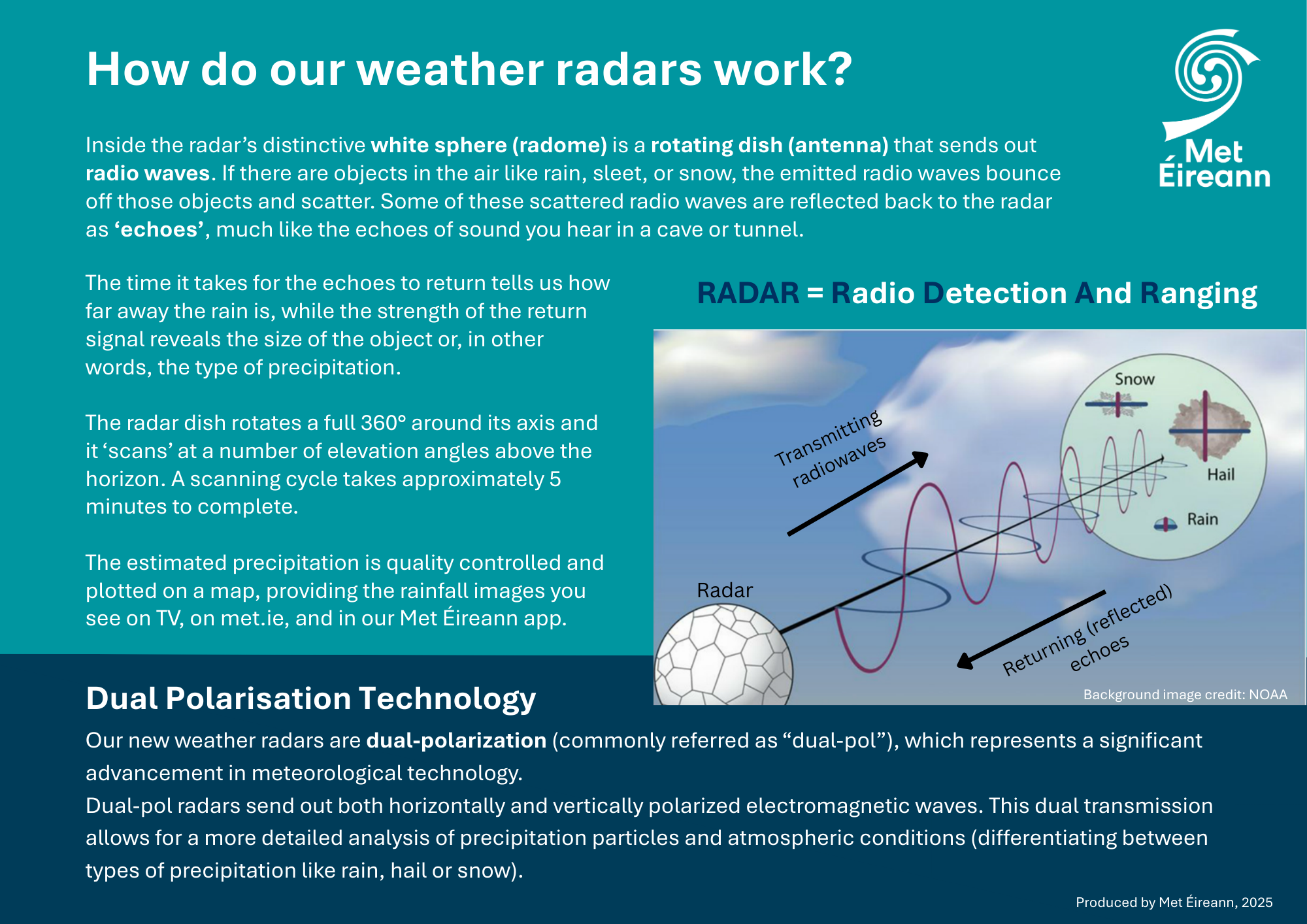
Weather radars provide a near-real-time picture of the location and intensity of precipitation across the country. A weather radar measures the location and intensity of precipitation within its radius of coverage, as well as different types of precipitation (rainfall, snow, etc.).
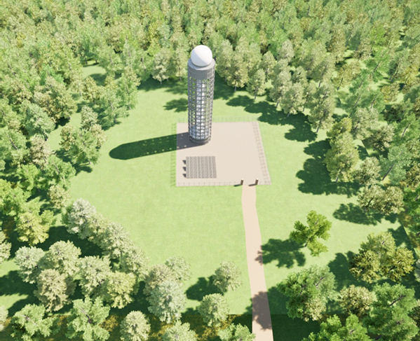
Figure 1. Computer generated image of the proposed weather radar station
How is data from weather radars used?
Weather radar data is analysed, processed and utilised by Met Éireann in various ways:
- Forecasters and flood forecasters analyses: Our weather and flood forecasters use the data to have a picture of the current rainfall situation and compare it with what the weather and flood forecasting models show, as part of the analyses performed before producing a forecast.
- Rainfall visualisation maps on met.ie, the Met Éireann app and RTÉ Weather: Weather radar information is used continually by stakeholders such as local authorities and emergency services, as well as citizens, to be able to plan weather responses effectively and efficiently. Radar data is visualised in maps shared on met.ie and on the Met Éireann app, as well as broadcasted on RTÉ Weather.
- Essential input to forecasting models: Radar data is used as an input to weather and flood forecasting models, to predict the evolution of rainfall and flooding conditions. The more accurate the inputs into the models, the more accurate the forecasts are.
All of the above are part of the weather services Met Éireann provide, which are fundamental for public safety during severe and high-impact weather events.
-
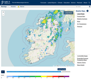
- Figure 2a. Rainfall radar images available on www.met.ie
-
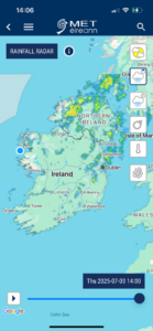
- Figure 2b. Rainfall radar images available on the Met Éireann app
Key Benefits of the Expanded National Weather Radar Network
- Better Rainfall Coverage: More weather radars across Ireland mean Met Éireann can track rain more accurately in every part of the country.
- Improved Forecasts and Warnings: Flood and rainfall forecasts and warnings will be more accurate, helping to protect lives, homes, and businesses across Ireland.
- More Local Detail: Communities near the new radars will get the most precise rainfall data, helping with local planning and safety.
- Smarter Technology: The new radars will use dual-polarisation technology which can tell the difference between rain, snow, and hail, giving clearer and more reliable information.
- Real-Time Rain Updates: A new ‘nowcasting’ service will be developed to show imminent rainfall, giving people and organisations time to prepare.
- A More Reliable Network: With seven radars instead of two, there’s backup coverage if one goes offline, reducing the risk of blind spots.
- Support for Economy and Society: Farmers, airlines, sports groups, local authorities, and many others will all benefit from better planning and reduced weather disruption.
Other key benefits for individual groups include:
Local Authorities & Emergency Services:
- More precise flood and rainfall forecasts and warnings to help with early response.
- Better data to plan road safety, public transport, and drainage systems.
- Improved protection of vulnerable communities during severe weather.
Aviation & Transport Sector:
- Safer flight planning with better knowledge of rainfall patterns.
- Improved road safety through more precise alerts for hazardous conditions and better visualisation of current precipitation conditions.
The Farming Community:
- More accurate rainfall data to plan planting, spraying, and harvesting.
- Support to reduce losses from flooding and waterlogged land.
- Livestock and feed managed with more certainty during extreme weather.
GAA & Sports Clubs:
- Plan training sessions and matches with up-to-date rain forecasts.
- Reduce cancellations and improve pitch maintenance by knowing when intense rain is expected.
- Keep players and supporters safe during sudden severe rainfall events.
General Public & Local Communities:
- Easier access to accurate rainfall maps and forecasts on the Met Éireann app and website.
- More reliable information for day-to-day decisions – from commuting to laundry or outdoor events.
- Greater peace of mind during storms and floods.
Locations and site selection rationale
| County | Townland |
| Cork | Piercetown |
| Donegal | Loughfad |
| Kilkenny | Brown Mountain |
| Meath | Castlerickard |
| Roscommon | Cloonfad |
Met Éireann has carried out a long term and detailed assessment of the spatial coverage and suitability of the current national weather radar network as well as future network requirements. As part of this assessment, a selection process carefully analysed and reviewed thousands of possible locations across the country, following international best practice over several years.
Due to the technical requirements of weather radar systems and the need for visually unobstructed locations, many sites were deemed unsuitable. As such, the selected locations have been strategically assessed using a multi-stage, multi-requirement, multi-criteria assessment process, to identify the optimal position for each radar system.
While the assessment process for each possible location was extensive, obtaining minimal radar beam blockage was a key requirement for a site to be deemed suitable. As such, beam blockage modelling was carried out for each considered site using a digital terrain map and software, which models how that terrain would block a 360° weather radar scan. Each of the selected sites meet this important core need to enable effective operation of each weather radar.
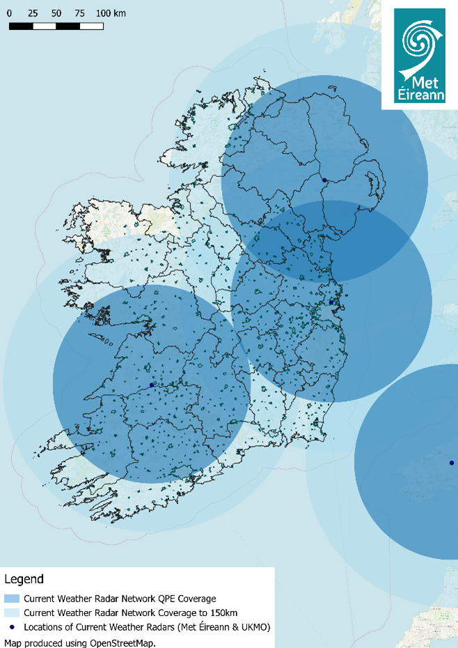
Figure 3. Current weather radar network coverage over the Island of Ireland (includes UK Met Office radars)
Overall, the following rationale and requirements underpin the selection of the proposed locations.
- Each weather radar must have a 360°unobstructed view of the surroundings and be at an elevation low enough to capture the weather occurring below approximately 1,000 meters in elevation, but high enough to avoid any obstacles that may block the radar scan in the local surroundings.
- The topography many kilometers away from the proposed location in all directions of each radar must also be considered, along with local obstacles for the weather radar scans. Semi-remote locations are ideal as urban areas generally have large buildings or masts that block radar scans.
- These proposed weather radar locations cannot be viewed in isolation as the weather radar network will work in unison to ensure complete local and national coverage. This impacts on the location of each radar station. For example, each radar site needs to provide contingency coverage for at least one other weather radar, while not overlapping significantly with other sites.
- Land management, site access, environmental and/or other impact assessments of the surrounding areas were also considered during the site selection process.
Proposed Regions and Sites for New Weather Radars
South-East (Brown Mountain/Reevanagh, Co. Kilkenny)
Local authorities have issued a final grant of planning permission.
Information on the construction timeline and the construction management plan, including a traffic management plan, will be finalised once a main contractor has been appointed and other project details are confirmed. Relevant updates will be provided through this project webpage in due course.
The selected site is located approximately 10km north-east of Kilkenny City, close to the Kilkenny-Carlow border. It is a greenfield zone situated within the Reevanagh Woods, a natural forest area surrounded by low-lying vegetation, bounded by other stretches of forests and agricultural lands where forestry and agriculture are principal land uses.
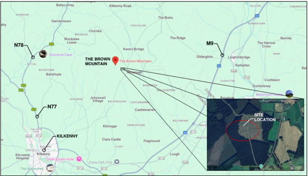
Figure 4. Map location of the proposed radar site at Brown Mountain/Reevanagh, Co. Kilkenny
Why this site?
This site was selected as it offers coverage of the vast majority of the south-east which is an area currently poorly observed both by the Dublin radar (due to blocking by the Wicklow Mountains) and by the Shannon radar due to distance.
The Brown Mountain site, due to its elevated position, has little beam blockage bar in the direction of Mount Leinster and the Blackstairs Mountain. This weather radar will provide excellent precipitation coverage over the large population centers of Kilkenny, Wexford and Waterford. In conjunction with the proposed site in Cork, these two weather radars will offer vastly improved radar coverage in the entire south of the country while also offering each other some contingency.
South-West (Piercetown, Co. Cork)
The selected site is located in the Cottages, Doolieve, approximately 12km south of Cork City . It is a greenfield zone situated in the Piercetown townland, a natural forest area surrounded by trees and low-lying vegetation, bounded by other stretches of forests and agricultural lands where forestry and agriculture are principal land uses.
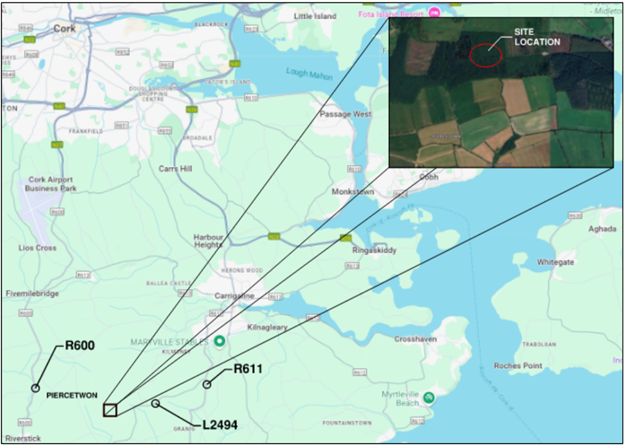
Figure 5. Map location of the proposed radar site at Piercetown, Co. Cork
Why this site?
This site was selected as it offers enhanced coverage of Cork City while also providing excellent coverage along the South-West coast. A radar at this site offers improved observations of approaching weather systems from the South-West, which is the direction most of Ireland’s weather systems come from.
The Piercetown site has minimal beam blockage in all directions due to its coastal position far from mountain ranges to the north and northwest. Proximity to Cork city will vastly improve radar coverage of Ireland’s second largest city and of Cork airport, as well as of key river catchments and areas prone to flooding.
West (Cloonfad, Co. Roscommon)
Local authorities have issued a final grant of planning permission.
Information on the construction timeline and the construction management plan, including a traffic management plan, will be finalised once a main contractor has been appointed and other project details are confirmed. Relevant updates will be provided through this project webpage in due course.
The selected site is located approximately 10km south-east of Ballyhaunis and about 2 km east of the N83 at the Roscommon-Galway border. It is a greenfield zone situated within the Cloonerkaun, a natural forest area surrounded by trees, foliage and low-lying vegetation, bounded by other stretches of forests and agricultural lands where forestry and agriculture are the principal land uses.
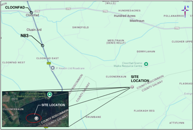
Figure 6. Map location of the proposed radar site at Cloonfad, Co. Roscommon
Why this site?
This site was selected as it will offer improved coverage over poorly observed areas of the western seaboard in Galway and Mayo, due to their distance from the existing Shannon weather radar, while also covering most of the north midlands.
This elevated site near Cloonfad has unblocked coverage in all directions. Beam blockage modelling was done using a digital terrain map and software which models how that terrain would block a radar beam from the proposed site. A new radar in this location will provide excellent coverage over some of the wettest locations along the west coast and mid-west region.
North-West (Loughfad, Co. Donegal)
Local authorities have issued a final grant of planning permission.
Information on the construction timeline and the construction management plan, including a traffic management plan, will be finalised once a main contractor has been appointed and other project details are confirmed. Relevant updates will be provided through this project webpage in due course.
This site is located near Loughfad, approximately 14km southeast of Donegal. It is a greenfield zone situated within a natural forest area surrounded by trees and low-lying vegetation, bounded by other stretches of forests and farmlands where forestry and farming are principal land uses.
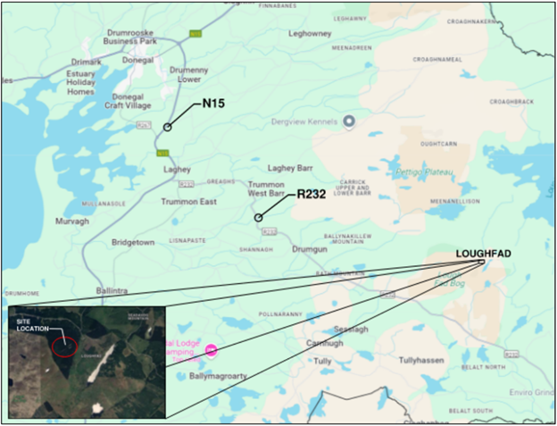
Figure 7. Map location of the proposed radar site at Loughfad, Co. Donegal
Why this site?
This site in Donegal will vastly improve weather radar coverage in the North-West, where rainfall is currently poorly observed due to distance from the existing Dublin and Shannon radars.
Given the mountainous and hilly terrain of Donegal, all sites investigated had some amount of beam blockage. The selected site at Loughfad has a degree of beam blockage to the north and northeast, but good coverage for rainfall coming from the South-West to the South-East, which are directions that rainfall commonly comes from. While offering good coverage of most of Donegal County, the southerly location within the county also improves coverage across parts of Mayo, Sligo and the border counties.
East (Castlerickard, Co. Meath.)
Local authorities have issued a final grant of planning permission.
Information on the construction timeline and the construction management plan, including a traffic management plan, will be finalised once a main contractor has been appointed and other project details are confirmed. Relevant updates will be provided through this project webpage in due course.
This site is located approximately 10km southwest of Trim at coordinates. It is a greenfield zone situated within the Castlerickard natural forest area surrounded by trees, foliage and low lying vegetation, bounded by other stretches of forests and farmlands where forestry and farming are principal land uses.
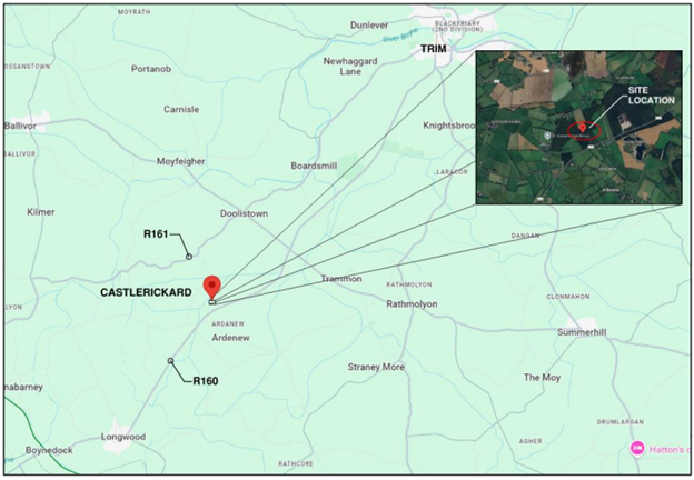
Figure 8. Map location of the proposed radar site at Castlerickard, Co. Meath.
Why this site?
This site in Meath will ensure good coverage of some north midland areas and the border counties which lie a distance from the existing Dublin radar and the other proposed new sites and also provide contingency for the densely populated east coast.
This site in Castlerickard has unblocked coverage in all directions, due to the surrounding flat terrain. Beam blockage modelling was done using a digital terrain map and software which models how that terrain would block a radar beam from the proposed site. A new radar in this location will provide excellent coverage for the populated east coast along with improved coverage in the north midlands and border counties.
How will Met Éireann communicate about the plans going forward?
This webpage will be routinely updated to reflect the projects progress overall and, on a site-by-site basis and to provide new useful information to the local stakeholders and communities.
Want to know more? Contact us
Email: wren@met.ie
Phone: +353-1-8064200
Hours: 09:00 – 17:30
Additional Information
Latest Radar: Weather Maps – Met Éireann – The Irish Meteorological Service
Frequently Asked Questions (FAQ’s)
A series of useful questions and answers relating to the planning application and approval process. This section will be updated continually over the lifetime of the project.
What will the weather radars look like at the proposed locations?
The weather radar station consists of a radar system, a tower and supporting infrastructure. These weather radar stations have been designed to be unmanned and automated stations. The tower will have a white radome on top, this is a dome that covers the radar, with a water repellant coating that protects the radar inside from wind and rain. The towers’ function is to allow the radar to operate with an unobstructed view of the sky and surroundings and to provide space to house the measurement equipment. At the top and bottom of the towers are equipment rooms that house the weather radar measuring equipment, metering for utilities etc. A photo voltaic solar array has been included per site which will power most of the energy needed for the weather radar station.
During the preliminary design phase great emphasis was made by the engineering and architecture teams to design a tower with a minimal footprint forming a soft silhouette on the skyline. This was done by using a circular rather than a square tower shape and by maximising the space within the tower to locate all the necessary equipment, avoiding the need for additional buildings.
The weather radar station is comprised of:
- A rotating antenna, which is mounted on top of the tower, inside a radome (white dome)
- A metal tower with stairway access to the top of the tower
- Radar equipment rooms at the top and bottom of the tower
- A PV solar array only for use by the weather radar station
- Security fencing around the immediate perimeter of the tower
Figure 9. Computer generated image of the proposed weather radar station