By Meteorologist Liz Walsh. Also available in our Meteorologist’s Commentary page.
The 2020 Hurricane Season is shaping up to be one of the most active hurricane seasons on record with 20 named storms so far as of Friday 18th September 2020 at 9am Irish Time.
The average number of storms over the entire season which stretches from June 1 through to November 30 is 12, with 6 of those storms strengthening to hurricane, and 3 of the 12 strengthening to Major Hurricane Strength (classified as Category 3 or more on the Saffir- Simpson Hurricane Wind Scale [1]). Note that a tropical storm is a tropical cyclone that has maximum sustained surface winds ranging from 39-73 mph / 63-119 km/h / 34-63 knots). A hurricane is a tropical cyclone that has maximum sustained surface winds of 74 mph / 119 km/h/ 64 knots or greater.
On the 14th September, the US National Hurricane Center issued advisories on five tropical cyclones over the Atlantic basin – tying with the record for the most number of tropical cyclones in that basin at one time, last set in September 1971.
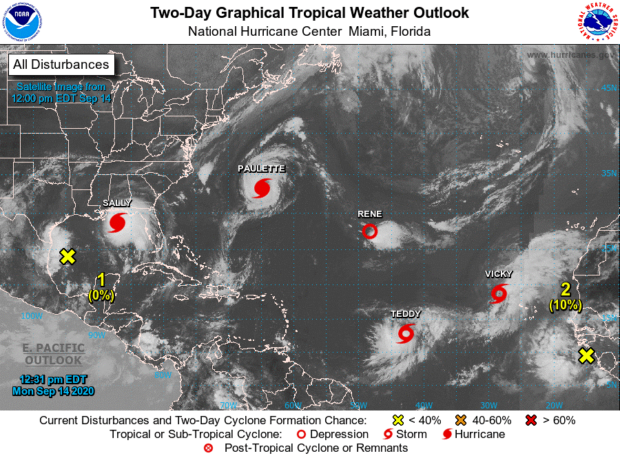
Image above from National Hurricane Center on September 14th 2020.
As predicted by the US National Oceanic and Atmospheric Administration [2], the 2020 season has seen an exceptionally high number of named storms, reaching the letter V (Vicky) as of Monday 14 September. Vicky is the earliest 20th Atlantic named storm on record. The old record was set by Vince on October 9, 2005. The season lasts until 30 November.
Only the name Wilfred remains, and there are currently two tropical disturbances that are candidates to claim that name over the next day or so. One disturbance located over the south-western Gulf of Mexico currently labelled as Tropical Depression Twenty-two, and another disturbance located a few hundred miles southwest of the Cabo Verde Islands off the coast of West Africa. So it is quite possible that both Wilfred and Alpha could be named by the National Hurricane Center by the end of this weekend.
The hurricane name lists include only 21 letters out of 26, because it is not easy to find 6 appropriate names (for the 6 rotating lists) starting with Q, U, X, Y and Z. In the interests of safety, names must be easily recognizable. In addition, they have to reflect a balance between French, Spanish and English names due to the geographical coverage of the storms throughout the Atlantic and Caribbean, and respect societal sensitivities.
The use of the Greek alphabet (Alpha, Beta, Gamma, Delta, Epsilon, Zeta, Eta, Theta, etc.) has only happened once before in 2005, when six names from the Greek Alphabet were used.
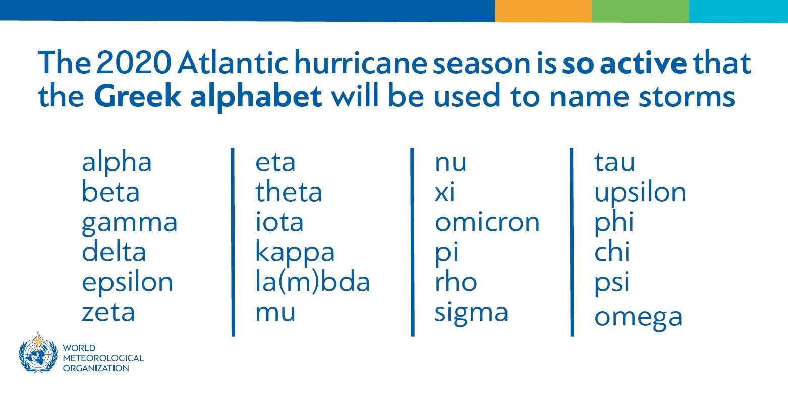
Image above from the World Meteorological Organisation
2005 was a record-breaking year with devastating hurricanes including Katrina, Rita and Wilma, whose names were all retired.
While 2020 is comparable to 2005 with regard to the number of storms, the strength or intensity of the storms so far this year has been less. By the 18th September in 2005, there had been 4 storms that had become major Hurricanes (classified as Category 3 or more) in the Atlantic Basin (including Katrina) and advisories had begun on what would become the 5th one, Rita.
In comparison, this year, 2020, there have been only 2 storms that have reached major hurricane status in the basin so far, Hurricane Laura, which reached Category 4 on the 26th August and Hurricane Teddy which intensified to a Category 4 hurricane last night (Irish time) and is expected to approach Bermuda this weekend. There are still over two months left in the season so there is still time for additional storms to join Laura and Teddy on the list of Major Hurricanes for 2020.
Factors that have been cited by the National Oceanic and Atmospheric Administration to cause this “extremely active” hurricane season include
- warmer-than-average sea surface temperatures in the tropical Atlantic Ocean and Caribbean Sea
- reduced vertical wind shear (i.e. change in wind speed or direction with change in height)
- weaker tropical Atlantic trade winds (Trade winds are the prevailing easterly winds that flow in the Earth’s equatorial region)
- an enhanced West African Monsoon (Characterised by changes in surface wind field over Western Africa leading to summer rainfall (wet season) and winter drought (dry season)).
Climate Drivers
A main climate factor driving the above mentioned conditions is the ongoing warm phase of the Atlantic Multi-Decadal Oscillation, which reappeared in 1995 and has been favouring more active hurricane seasons since that time.
Another contributing climate factor this year is the possibility of La Niña developing in the months ahead. La Niña conditions are classified as cooler-than-average sea surface temperatures in the equatorial regions of the eastern Pacific Ocean. Downstream effects of La Niña can further weaken the wind shear over the Atlantic Basin, allowing storms to develop and intensify. Current key indicators are currently at or approaching La Niña thresholds [3].
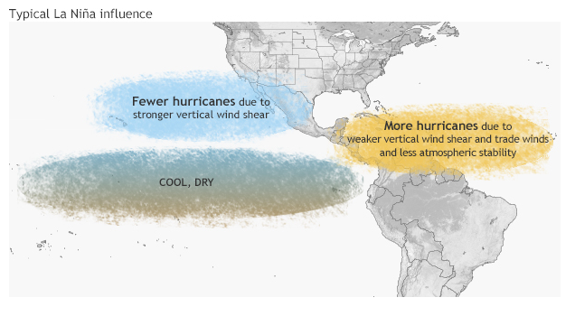
Image above from NOAA Climate.gov
Hurricane Season and Climate Change
The general consensus among the scientific community at the moment is that the warmer waters we are likely to experience in a warmer world will lead to stronger storms. What is less agreed upon, though, is the number of storms. The general hypothesis is that we expect to see either a decrease in the overall frequency of hurricanes or for it to remain unchanged. This scenario is generally believed to be a by-product of increasing wind shear in the tropics. There is not a perfect consensus on this, however, with a smaller number of studies that simulate an increase in the number of storms. So in terms of number of storms, this is still an area of active research.
An increase in the frequency of very intense storms, however, is generally accepted as a consequence of climate change regardless of whether the number of storms increase/decrease or stay the same. The impacts of this trend are likely to be exacerbated by sea level rise and a growing population along coastlines. There is also the possibility that where cyclones reach maximum intensity will extend further northwards or poleward due to warmer sea surface temperatures.
What can we expect over the next couple of weeks and months?
The large scale pattern looks to generally remain conducive for Atlantic hurricane formation and intensification, although not as conducive as during the past two weeks according to the latest forecasts from Colorado State University of Atlantic Hurricane Activity as of the 16th September 2020. [4].
We have passed the peak of Atlantic Hurricane Season but there is still a way to go and as we head through the latter part of September and October. The delayed warming of the Atlantic Ocean forces the location of extra-tropical transitioning storms northward late in the season so here in Ireland, we are more likely to see the remnants of these storms influencing our weather over the coming weeks and months.
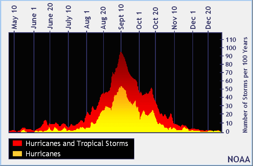
Image from the National Hurricane Center showing the average spread of storms during the season, with the peak of season on September 10th.
Met Éireann Podcast
For further information on Hurricanes, have a listen to our Met Éireann Podcast on Hurricanes with National Hurricane Center Senior Hurricane Specialist, John Cangialosi.
https://www.met.ie/education/podcast
For the latest satellite imagery, visit:
https://www.star.nesdis.noaa.gov/GOES/sector_band.php?sat=G16§or=taw&band=13&length=24
https://www.met.ie/latest-reports/satellites/world-infrared
For the latest weather outlook for Ireland, go to:
https://www.met.ie/forecasts/national-forecast
Works Cited in this commentary:
| [1] | National Hurricane Center, “Saffir-Simpson Hurricane Wind Scale,” [Online]. Available: https://www.nhc.noaa.gov/aboutsshws.php. |
| [2] | NOAA, “Extremely active’ hurricane season possible for Atlantic Basin,” [Online]. Available: 2. https://www.noaa.gov/media-release/extremely-active-hurricane-season-possible-for-atlantic-basin. |
| [3] | BOM, “Climate Driver Update,” 15 September 2020. [Online]. Available: http://www.bom.gov.au/climate/enso/#tabs=Overview. |
| [4] | P. J. Klotzbach, M. M. Bell and J. Jones, “COLORADO STATE UNIVERSITY FORECAST OF ATLANTIC HURRICANE ACTIVITY FROM SEPTEMBER 16 – SEPTEMBER 29, 2020,” COLORADO STATE UNIVERSITY, 2020. |