By Meteorologist, Liz Walsh and Hydro-meteorologist, Stephen Carey. Taken from the Meteorologist’s Commentary, further updates will be published there.
Posted: 1400 24th December, Christmas Eve
Whilst Christmas Day itself promises to be a generally quiet day weather wise with increasing cloud, and patchy rain and drizzle, mainly over northwestern areas, our weather looks set to turn much more unsettled as we head into the festive weekend.
A briefly milder spell of wet and windy, potentially stormy, weather is expected on Saturday in association with Storm Bella named by the British Met Office earlier today, with much colder weather following for Sunday and into early next week.
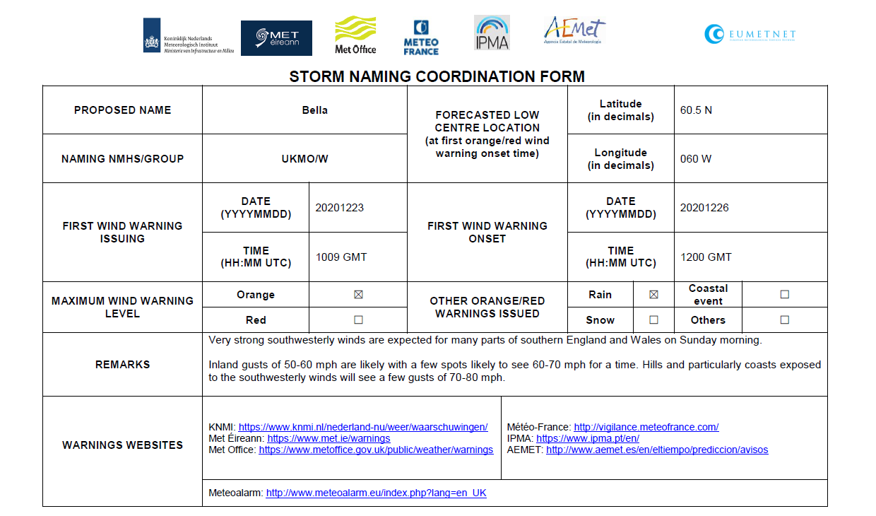
Storm Naming Form Storm Bella
Some very cold air currently emerging from northwest Canada and Greenland, is expected to meet relatively warm air over the western Atlantic, resulting in a powering up of the Polar Front Jet Stream. A complex low pressure system, named Storm Bella by the UK Met Office this morning, is tracking eastwards over Greenland today (Christmas Eve). The low looks set to engage the developmental zone of this powered up Jet Stream, which will help to deepen it to the north of Iceland on Friday, Christmas Day. Storm Bella will be tracking eastwards over parts of Iceland by Saturday afternoon, and is expected to have grown into quite a large feature by then, generating a vast swathe of gales, westerly veering northerly, across the North Atlantic as it interacts with the Azores high to the south. Storm Bella is then forecast to track southeastwards towards the North Sea whilst deepening a little more into Saturday night bringing a spell of wet and very windy weather over Ireland for Saturday afternoon/evening/night as an associated squally cold front tracks southeastwards over the country.
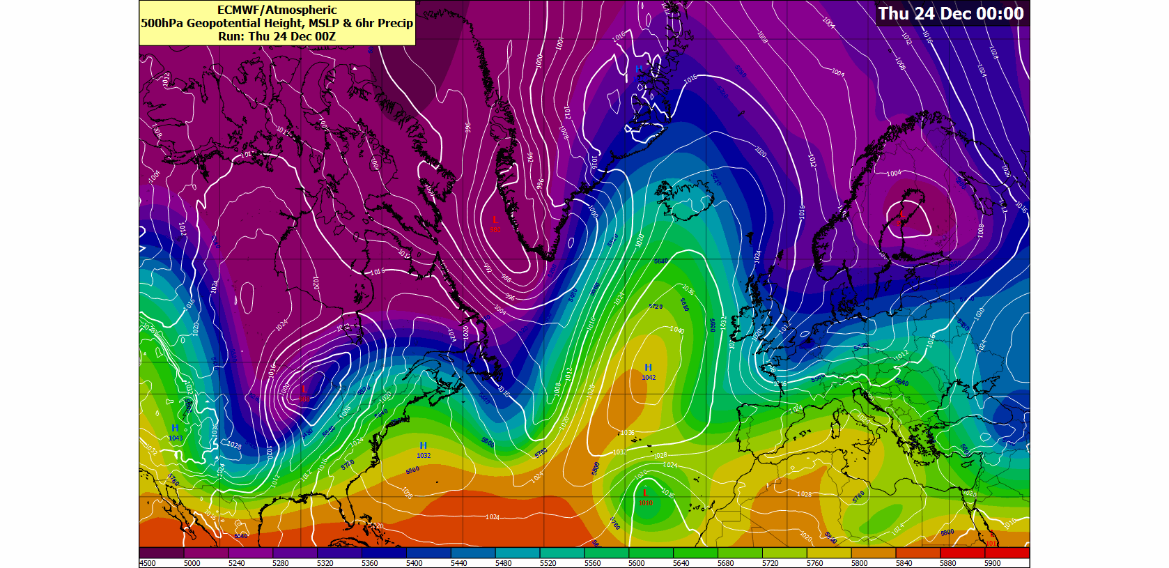
Animation courtesy of the ECMWF showing Mean Sea Level Pressure (white lines) overlaid with 500hPa Geopotential Height. Geopotential heights are lower in cold airmasses and higher in warm airmasses. So, the darker purple colours, indicative of lower geopotential heights are also indicative of very cold air high up in the Atmosphere, while the green-yellow-orange colours are indicative of relatively warmer air high up in the Atmosphere.
A yellow level wind warning has now been issued for Saturday for Connacht, Donegal and western parts of Munster, valid from Midday on Saturday through to 6am on Sunday, and the situation will continue to be monitored by Met Éireann’s meteorologists through Christmas Day and updated as required.
The UK Met Office have issued yellow and amber wind warnings over parts of England and Wales for Saturday and Sunday.
Coastal Flood Risk
The combination of forecast storm surge and very unsettled, potentially stormy conditions, associated with a Storm Bella on Saturday/ Sunday, is likely to increase the risk of coastal flooding (spray over-topping and localised wave over-topping), especially in flood-prone areas along Irish coasts (particularly when coincident with High Tides and onshore winds).
Please see the approximate High Tide times below for Saturday & Sunday:
Saturday (St Stephen’s Day) 26th December 2020:
West and South coasts: 02:00 – 04:00 & 14:00 – 16:30 (early morning and afternoon)
East coast: 08:00 – 09:30 & 20:30 – 22:00 (morning and evening)
Sunday 27th December 2020:
West and South coasts: 02:30 – 04:30 & 15:00 –17:00 (early morning and evening)
East coast: 09:00 – 10:30 & 21:00 – 22:30 (late morning / and late evening)
River Flood Risk
Soils are mostly saturated countrywide, and waterlogged in some places. Rivers are already elevated in the western and southern half of the country in response to appreciable rainfall over the last week or so. Whilst forecast rainfall may not reach rainfall warning criteria, heavy rainfall may cause localised flooding.
Turning colder again from Saturday night onwards
Behind the cold front on Saturday night, some rather cold and deeply unstable air will bring showers on Sunday and early next week. Some of these showers will have a wintry flavour to them, with a mix of rain, hail, sleet and possibly some snow likely. People travelling by road from Saturday night onwards are advised to watch out for the risk of icy stretches and poor visibility in showers.
Stay up to date with Met Éireann’s weather and warnings throughout this Christmas period at: