This is a preliminary report, based on the data from our Synoptic stations, and will be updated when all the data from our Climate stations is received.
There were intense thunderstorms especially on the 1st and 8th June, but in general the dry, settled weather from the end of May continued for the first two weeks of June with high pressure in charge and a slack easterly flow. The north Atlantic jet stream stayed well to the north. There was a break in the fine weather for the third week of the month. Storm Hector passed close to the Northwest, giving two days of rain and gales on the 13th and 14th followed by frontal systems crossing the country from the west up to the 20th. Even during this unsettled spell, rainfall totals were very low especially in the South and East. From the 21st, the remainder of the month and first part of July was settled and exceptionally dry due to an area of high pressure building over Ireland. Heat wave and partial drought conditions were reported in many locations. Absolute Droughts are now ongoing.
On June 21st, an area of high pressure of up to 1035 hPa was centred to the west of Ireland bringing a northwesterly air flow across Ireland. In the days that followed, an easterly airflow dominated our weather. As high pressure persists over Ireland, it has brought the warmest conditions so far in 2018, with the highest maximum temperature of 32.0°C recorded at Shannon Airport on the 28th June.
Five Synoptic stations in the West and South had a max temp of over 30°C on the 28th June 2018. These were Shannon Airport, Mount Dillon, Claremorris, Athenry and Moore Park. On 29th June, Shannon Airport was the only station which recorded above 30 °C with a temperature of 31.1 °C.
The weather for June and early July 2018 has been warm and dry with mean temperatures 1.8 °C above normal on average and rainfall just 50% of normal in the west and as low as 5% of normal in the east. This follows on from what was a dry and warm May.
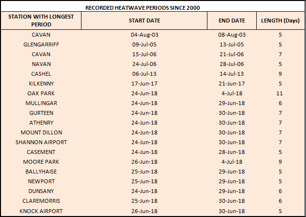
HEATWAVES
Definition: A heatwave occurs where there are 5 consecutive days or more with maximum temperature over 25 degrees Celsius (i.e. daily maximum temperature > 25 °C.)
Official heatwaves were recorded at thirteen Synoptic stations this year, (See table below). These occurred in the East, the Midlands, the West and the South.
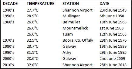
HIGHEST JUNE MAXIMUM TEMPERATURES PER DECADE
SUNSHINE
The highest daily sunshine for June this year was 16.5 hours at Malin Head on the 28th June. A value of 16.0 hours was recorded at Knock Airport on the 24thJune, its highest daily value since the station opened in 1997. All stations had above average sunshine for June. Percentage of monthly sunshine values ranged from 139% (monthly sunshine total of 200.6 hours) at Knock Airport, Co Mayo to 160% (monthly sunshine total of 256.6 hours) at Casement Aerodrome, Co Dublin. Monthly sunshine totals for June were highest at Johnstown Castle, Co Wexford with 279.9 hours.
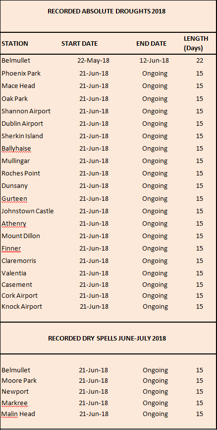
DROUGHT
Definitions: An absolute drought is a period of 15 or more consecutive days to none of which is credited 0.2 mm or more of precipitation (i.e. daily rainfall < 0.2 mm.)
A partial drought is a period of at least 29 consecutive days the mean daily rainfall of which does not exceed 0.2 mm (i.e. mean for period <= 0.2 mm.)
A dry spell is a period of 15 or more consecutive days to none of which is credited 1.0 mm or more of precipitation (i.e. daily rainfall < 1.0 mm.)
Soil moisture deficits are now over 55mm in the West and North, over 75mm in the South and over 85mm in the East and Southeast.
We are now recording Absolute droughts and dry spells at all our Synoptic stations. (See table below). An absolute drought occurred at Belmullet earlier in the month also (see table below). The last time there were drought conditions in Ireland was April-May 2017 in the Midlands and the West.
RECENT MAXIMUM TEMPERATURE INFORMATION
The last time a June temperature in Ireland was above 31.5 °C was 29-Jun-1976 at Shannon Airport, Co Clare (when it was 31.6 °C) and on the same day at Boora, Co Offaly (when it was 32.5 °C).
32.0 °C was the highest temperature recorded so far this year (it was recorded on 28th June 2018) at Shannon Airport and this is the highest June temperature recorded in Ireland since 1976. It is the highest temperature for any month since July 2006, (where 32.3 °C was recorded at Elphin, Co Roscommon on 19th July 2006). 32.0 °C is the highest temperature ever recorded at a Synoptic station in Ireland (and it was recorded on 28th June 2018 at Shannon Airport).
What is a heatwave?
A heatwave refers to a prolonged period of abnormally hot weather which may be accompanied by high humidity. While there is no generally accepted definition of a heatwave, in Ireland it’s classified as 5 consecutive days with a maximum temperature in excess of 25 degrees Celsius.
Why and when do heatwaves happen?
Heatwaves are most common in summer when high pressure develops over the country. High pressure systems, also known as anticyclones, are slow moving and can persist for a prolonged period of time, resulting in dry and settled weather. In anticyclones, cool air descends from aloft and diverges outwards at lower levels. As the air descends it is warmed by compression. The position of the jet stream over Ireland determines the type of weather we experience. When a high pressure system materialises over Ireland, the jet stream is usually located to the north of us and keeps low pressure systems away.
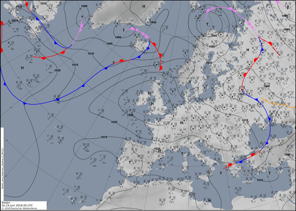
Above: Surface pressure chart for 24th June 2018 showing a Tropical Continental (TC) air mass affecting Ireland, bringing highest maximum temperatures close to 30°C.
Different air masses affect us at different times of the year and this has a major impact upon the weather we experience in this country. The Tropical Continental air mass is the least frequent air mass affecting Ireland and is most common in summer when sub-tropical high pressure moves north. This air mass originates over North Africa and tracks northwards over continental Europe. Although the lower layers of this air mass are usually quite stable, the unstable upper layers may give rise to severe thunderstorms. Its low humidity tends to bring us clear skies and long periods of sunshine. The highest temperatures experienced in Ireland usually occur under the influence of this air mass giving maximum temperatures in excess of 30 °C.
Ireland only experiences occasional heatwaves which are usually less frequent and not as prolonged as those found in more southerly latitudes. In August 1976, Birr recorded heatwave conditions lasting 14 days. More recently, heatwave conditions occurred in the summers of 2017, 2013, 2006, 2003, 1995, 1989 and 1983.
Report issued by the Climate Services, Climatology & Observations Division, Met Éireann 6th July 2018 at 10am.
The latest June Weather Summary is available here https://www.met.ie/climate/past-weather-statements