After the warmest spring on record, provisional data from Met Éireann’s long term stations[1] (dating back to 1900) shows that this summer has become the warmest summer on record for Ireland, surpassing the previous record by 0.08°C.
Wednesday, 3rd September 2025
Summer 2025 has provisionally surpassed the summer of 1995 as the warmest on record for Ireland, with an average temperature of 16.19 °C, which is 1.94 °C above Ireland’s long-term average (LTA) and marginally warmer (0.08 °C) than the previous warmest summer of 1995.
Met Éireann Climatologist, Paul Moore, says:
“Provisional Met Éireann data shows that summer 2025 is the warmest on record since 1900, when this temperature dataset began. It hasn’t been particularly sunny during summer, but the dry soils from a warm and sunny spring, the heat domes over mainland Europe, periods of high-pressure dominance and the high sea surface temperatures around Ireland, have kept temperatures over the last three months consistently above average, especially at nighttime. It’s a close call with the previous record held by summer 1995, as summer 2025 average temperature surpasses 1995’s by only 0.08°C, even taking into account the temperature drop observed on the last week of August.
The added heat in the system and the continuous background warming due to climate change, can now transform an unexceptional season into a record breaking one. Ireland is experiencing the effects of climate change, and our climate projections show that our climate is going to become warmer. 2025 has already seen the warmest spring on record and now summer 2025 is another example of the warming trend, making it the first year since 1933 with consecutive Spring-Summer records.”
[1] Long Term Island of Ireland Temperature series
Top 10 warmest summers for Ireland
The chart below shows the top 10 warmest summers for Ireland since 1900, according to the Long-Term Island of Ireland temperature series.
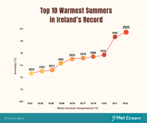
Figure 1: Top 10 warmest summers on record for Ireland, showing the anomaly (°C) with respect to Ireland’s LTA.
Of the top 10 warmest summers, six of them have occurred since the 2000s (2025, 2006, 2018, 2023, 2013 and 2022, from warmest to least warm). The addition of 2025 to this list makes summer 2023 drop out of the top five warmest summers on record.
It is relevant to note that 1995 and 2025 are the only two summers, and seasons, to ever surpass an average temperature of 16°C for Ireland.
Meteorological overview
Summer 2025 was very warm overall and hot at times. Ireland was on the northern edge of high-pressure systems or heat domes situated to the south and east of us on numerous occasions throughout the three months of the summer. These heat domes brought widespread heatwave conditions across areas of the UK and mainland Europe, while also bringing a few transient hot spells for Ireland.
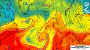
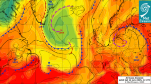
Fig. 2a and 2b –Example of synoptic situation during two of the hot spells Ireland saw this summer. Top image (2a) from 20th June 2025, when high pressure moved slowly to the east, moving the low pressure to the southwest, and drawing up a very warm airmass from the southeast. A maximum air temperature of 29.6°C was recorded at Mount Dillon. Bottom image (2b) from 12th July 2025, part of a four-day hot spell. High pressure moves over Ireland and moves slowly to the east, blocking Atlantic weather fronts to the west. This again draws a very warm airmass from the south. A maximum air temperature of 31.1 °C was recorded at Mount Dillon, becoming the highest temperature of the year so far at our 25 primary weather stations.
Occasionally, when Ireland lay in between low pressure to the north and high pressure to the south it was often quite cloudy, while staying relatively warm and dry.
On several occasions during the summer, high pressure to the south and east became more dominant, allowing hot air masses to push up from the south bringing periods of hot, dry and sunny weather. However, low pressure to the west and north was never too far away, keeping the hot periods relatively short for Ireland. On other occasions low pressure to the north and west became more dominant, bringing periods of rain or showers, at times heavy and thundery.
What led to the record-breaking summer of 2025, does climate change have something to do with it?
The persistent warmth we saw in June, July and August was driven by a combination of factors, with climate change being an underlying reason for these:
- Dry soils – Following our warmest Spring on record with dry and sunny conditions across the country, soils were very dry. With less evaporative cooling, heat can build and linger for longer.
- Heat domes to the south – Heat domes over western and central Europe (which caused a number of heatwaves there), occasionally pushed hot air masses over Ireland, bringing relatively short hot periods during each summer month (see Fig. 2 for examples).
- Marine heatwaves – While the severe marine heatwave during May 2025 eased off, Sea Surface Temperatures (SSTs) remained elevated around the coasts of Ireland during the summer. Marine heatwaves, although less severe, lingered through all three summer months, especially to the south of Ireland. This meant that the warm air masses moving up from the south during the summer could maintain more heat.
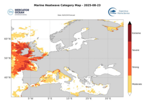
Fig 3 – Example of Marine heatwave in August 2025, Copernicus Marine Service. ‘Severe’ and ‘extreme’ sea surface temperatures can be seen on the coasts around Ireland.
- Warm nights – Most Met Éireann observing stations recorded their highest mean minimum temperature for summer on record, and several long-standing stations had their highest number of warm nights on record. With less sunshine and a lower number of hot days (days with maximum temperature > 25°C) compared to the next two warmest years on record, 1995 and 1976, the higher minimum temperatures during summer 2025 were a critical factor pushing the overall mean summer temperature higher. The elevated SST’s helped to keep nighttime temperatures higher in general.
Climate change has the power to turn previously unremarkable years into record-breaking ones, as baseline conditions steadily rise. This summer Ireland’s hot spells and European heatwaves, which might once have passed as pleasant spells of warm weather, are made more prominent by the heightened backdrop that climate change creates.
Climate change is affecting Ireland with an observed increase in air temperature of approximately 1.1°C since 1900. Over the period 1961-2020, Ireland’s mean air temperature increased at a rate of 0.22°C per decade. Differences in decadal trends can be seen at a seasonal or monthly level. In particular in summer months, minimum air temperatures have increased at a faster rate than maximum air temperatures.
And what do climate models say about the future?
Ireland’s current warming trend is expected to continue into the future. Future climate projections for Ireland from our TRANSLATE programme show that under both moderate and high emission scenarios, mean summer temperatures are projected to surpass the 2025 mean summer temperature of 16.19 °C as the century progresses. Maximum and minimum temperatures are projected to increase across all future scenarios annually and seasonally, with minimum summer temperatures expected to show a larger increase than maximum temperatures.
Wasn’t 1995 more memorable in terms of heat? How is this summer surpassing it?
The summer of 1995 remains one of the most remarkable in Ireland’s weather history. It started cool, with cooler than average SSTs around Ireland, but high pressure started to dominate and it warmed up, peaking in August with a marine heatwave developing also in August that year. Temperatures rose to around 30°C on a number of days, and Kilkenny had a total of 27 days with temperatures in excess of 25°C, compared to the normal 3 or 4. The highest temperature of that year was recorded there with 30.8°C on August 2nd.
Although 2025 hasn’t had such long-lived high temperature spikes, what is striking about it and has allowed it to marginally break the record, is the consistency of the warmth, with heat building up quickly and lingering. Both maximum and minimum temperatures have been above average over the three summer months, with minimum temperatures especially so, due to the persistent heat mentioned before. Each of the three summer months of 2025 are in their respective top ten warmest months on record. June 2025 ranked 4th, July ranked 9th and August ranked 4th on record, whereas the record-breaking summer of 1995 was driven by high temperatures mainly in July and August, with June 1995 only ranked as the 34th warmest June on record.
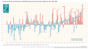
Fig 4 – Long-Term Summer Temperatures 1900-2025 as anomalies (difference from Ireland’s Long-Term Average 1961-1990)
What about rainfall? A slightly dry summer, but closer to average than to the driest summers ever.
Summer 2025 has come up as 2% drier than average, with 98% rainfall levels with respect to Ireland’s 1991-2020 LTA. Rainfall values were variable across the months (see Fig 5) and across the country. There was generally above average rainfall in the West and East of the country with below average rainfall in the South and Midlands. Percentage of seasonal rainfall values ranged from 55% (the season’s lowest rainfall total of 123.3mm) at Moore Park, Co Cork to 160 % (the season’s highest rainfall total of 460.3mm) at Athenry, Co Galway (its wettest Summer on record, length 31 years). The highest daily rainfall total was 55.4 mm at Dunsany, Co Meath on the 21st July (its highest daily fall for summer since 2014).
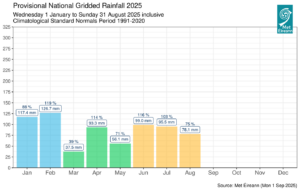
Fig 5 – Provisional National Gridded Rainfall 2025, monthly. While June and July were slightly above average in terms of rainfall, August was markedly below, allowing for overall below average summer 2025 rainfall levels.
Comparing this to the next warmest summers in the top 10, summer 1995 and 1976 were both drier with 56% and 55% of the LTA, respectively.
Will 2025 surpass 2023 as the warmest year on record for Ireland?
2025 has already seen the warmest spring and the warmest summer on record for Ireland, but we can’t say at this stage that it will become our warmest year on record as the weather is variable and the autumn and winter temperatures can heavily influence the yearly average.
However, it’s worth noting that this is the first year since 1933 with consecutive seasonal records (spring-summer) and six consecutive months in 2025 have averaged within their top 10 warmest month.
What we do know at global level is that, according to WMO, “La Niña” may return to impact weather and climate patterns from September onwards (60% chances from October onwards), but despite the temporary cooling influence of La Niña, temperatures are still expected to be above average for much of the world, including most of the Northern Hemisphere, according to their Global Seasonal Climate Update (September-November 2025).
For queries or interview opportunities with Met Éireann spokespersons, please contact: media@met.ie.
More on the Summer 2025 statement:
- Until 2025, average summer temperatures in Ireland ranged from 12.65 to 16.11°C (with 1995 holding a 126-year record starting in 1900).
- The previous warmest summer occurred 30 years ago in 1995, and the coldest summer was 113 years ago in 1912.
- August 2025 provisionally ranked 4th warmest August on record.
- The complete ‘Summer 2025 Climate Statement’ with more station data, record values and charts will be available here (choose Summer on drop down menu for month).
More on Ireland’s Long-Term Averages (30-year climate averages): please visit: 30 Year Averages – Met Éireann – The Irish Meteorological Service
More on Ireland’s Climate Projections from our TRANSLATE programme: please visit: TRANSLATE – Met Éireann – The Irish Meteorological Service