Met Éireann is the Irish National Meteorological Service as recognised by the World Meteorological Organisation under an international convention since 1950 and one of its most important roles is to protect life and ensure citizen safety. The service also supports the activities of the citizen and other agencies to mitigate damage to property and reduce disturbance to economic activity and so enhance support for impact-based decision making for weather events.
Met Éireann’s main suite of warnings are issued by the duty forecaster between 10am and midday and are updated as necessary as new information becomes available. In general, warnings will not be issued more than 60-hours ahead of the expected adverse weather but advisories on potential hazards are issued up to a week in advance.
Impacts from wind/rain/snow etc., vary depending on location, recent weather conditions, the state of ground, the time of year as well as the duration of the event. In particular the timing and location of the occurrence of extreme weather can significantly affect the impact which extreme weather may have on society, or on the economy.
The colour coding used by Met Éireann is fully aligned with international best practice and the European Meteoalarm system (www.meteoalarm.eu)
| Yellow | Not unusual weather. Localised danger. |
| Orange | Infrequent. Dangerous / disruptive. |
| Red | Rare. Extremely dangerous / destructive. |
National Emergency Coordination Group (NECG)
Local Authorities are the lead agencies for co-ordinating the response to severe weather emergencies. Where weather emergencies are judged to impact public safety at national level the National Emergency Coordination Group (NECG) is activated by the Office of Emergency Planning on request from the Department of Housing, Local Government and Heritage. This is the Lead Government Department for weather emergencies.
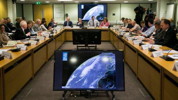
NECG October 2019
Met Éireann provides the weather briefings at the NECG, which brings together all Government Departments and relevant agencies and organisations, to support the locally led response and ensure coordination across the “Whole-of-Government” for the duration of the emergency.
Weather Advisories

Weather Advisories are issued up to about a week ahead to provide early information on potential hazardous weather. They may also be employed when a sum of weather elements acting together create a significant hazard, e.g. winds which may not be up to warnings strength but which, when combined with high tides and significant swell, generate a risk of flooding. Another possible use would be to advise of wind speed and direction on occasions of Volcanic Ash contamination. They might also be used to advise of expected significant medium-term accumulations of rain during a very unsettled period, when soils are known to be saturated. The issue of Weather Warnings and Weather Advisories is at all times down to the judgement of the Met Éireann Meteorologists/Forecasters.
When Will The Weather Warnings Be Issued?
In general Weather Warnings will be issued whenever weather conditions meeting the detailed thresholds defined below are anticipated within a 60-hr period. There will be judgement required on the part of the forecaster who must weigh up the possible severity of the weather conditions and the likelihood of their occurrence. However on some occasions (weekends, holiday periods) it may be necessary to issue Weather Warnings beyond this 60-hr horizon, if sufficient certainty derives from examination of the weather charts. Normally, however, a Weather Advisory (see above) will be used to flag severe weather beyond 60 hrs and Advisories will normally anticipate only “Orange” or “Red” criteria weather hazards.
Given that the thrust of the Weather Warnings service is on potential “Impacts” of weather rather than on the numerical values attained by the weather elements themselves, it may on occasion be appropriate to issue warnings at a level higher than that strictly justified by the anticipated weather elements. An example would be when heavy rain was expected which might not quite meet the “Orange Warning” criteria but which might give rise to significant flooding because of already saturated ground, or because of a combination of rain, wind and tide in a coastal location.
Weather Warning Criteria
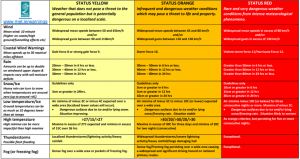
The criteria for the different warnings levels (Yellow, Orange, Red) and the different weather elements are laid out in the tables below.
IMPACT CONSIDERATIONS: These numerical criteria are strong guidelines but impacts from wind/rain/snow etc., vary depending on location, recent weather conditions, the state of ground, the time of year as well as the duration of the event. In any individual weather event, not every location in the warning area may experience the same degree of weather or impacts. When severe weather is expected, weather and impacts at lower levels are also likely to be experienced.
| STATUS YELLOW
Weather that does not pose a threat to the general population but is potentially dangerous on a localised scale. Be aware about meteorological conditions and check if you are exposed to danger by nature of your activity or your specific location. Do not take any avoidable risks |
| Wind Mean speed: 10 minute Gust |
Widespread mean speeds between 50 and 65km/h Widespread gusts between 90 and 110km/h |
| Coastal Wind Warnings Mean speeds up to 30 nautical miles offshore |
Gale force 8 / Strong Gale Force 9 |
| Rain Amounts can be up to double on windward upper slopes & impacts vary depending on for example soil moisture deficits |
20mm – 30mm in 6 hrs or less 30mm – 40mm in 12 hrs or less 30mm – 50mm in 24 hrs |
| Snow/Ice | 3cm or more in 24 hours |
| Low Temperature/Ice | Air minima of minus 3C or minus 4C expected over a wide area (localised lower values will occur). Dangerous surfaces due to ice and/or lying snow. Situation improving. |
| High Temperature | >27/15/>27 Maxima over a wide area in excess of 27C (localised higher values will occur) and minima in excess of 15C |
| Thunderstorm | Thunderstorms/lightning activity/heavy rainfall/hail |
| Fog (or freezing fog) | Dense fog over a wide area or pockets of freezing fog |
| STATUS ORANGE
Infrequent and dangerous weather conditions which may pose a threat to life and property. Prepare yourself in an appropriate way depending on location and activity. All people and property in the affected areas can be significantly impacted. Check your activity/event and delay or cancel as appropriate. |
| Wind Mean speed: 10 minute Gust |
Widespread mean speeds between 65 and 80km/h Widespread gusts between 110 and 130km/h |
| Coastal Wind Warnings Mean speeds up to 30 nautical miles offshore |
Storm Force 10 |
| Rain Amounts can be up to double on windward upper slopes & impacts vary depending on for example soil moisture deficits. |
30mm – 50mm in 6 hrs or less 40mm – 60mm in 12 hrs or less 50mm – 80mm in 24 hrs |
| Snow/Ice | 3cm or greater in 6 hrs 5cm or greater in 12 hrs 10cm or greater in 24 hrs |
| Low Temperature/Ice | Air minima of minus 5C to minus 10C (or lower) expected over a wide area. Dangerous surfaces due to ice and/or lying snow/freezing rain. Situation stable. |
| High Temperature | >30/20/>30/20/>30 Maxima in excess of 30C for three days and minima of 20C for two nights (consecutive). |
| Thunderstorm | Widespread thunderstorms/severe lightning activity/heavy rainfall/large damaging hail |
| Fog (or freezing fog) | Dense fog/freezing fog persisting over a wide area causing a widespread and significant driving hazard on national primary routes. |
| STATUS RED
Rare and very dangerous weather conditions from intense meteorological phenomena. Take action to protect yourself and your property. Follow instructions and advice given by the authorities under all circumstances and be prepared for exceptional measures. |
| Wind Mean speed: 10 minute Gust |
Widespread mean speeds in excess of 80km/h Widespread gusts in excess of 130km/h |
| Coastal Wind Warnings Mean speeds up to 30 nautical miles offshore |
Violent Storm Force 11 / Hurricane force 12 |
| Rain Amounts can be up to double on windward upper slopes & impacts vary depending on for example soil moisture deficits. |
Greater than 50mm in 6 hrs or less Greater than 60mm in 12 hrs or less Greater than 80mm in 24 hrs or less |
| Snow/Ice | 10cm or greater in 6 hrs 15cm or greater in 12 hrs 30cm or greater in 24 hrs |
| Low Temperature/Ice | Air minima minus 10C (or below) for three consecutive nights or more. Maxima of minus 2C. Dangerous surfaces due to ice and/or lying snow/freezing rain. Situation likely to worsen. |
| High Temperature | As Orange criterion, but persisting for five or more consecutive days & nights. |
| Thunderstorm | Exceptional |
| Fog (or freezing fog) | Exceptional |
Severe Weather Chart- Downloadable version
Marine Warnings
The Sea Area Forecast for 24-hours ahead is issued by the duty forecaster in Met Éireann 4 times a day; at midnight, 6am, noon and 6pm with relevant Small Craft Warnings/Gales Warnings for that period. These gale warnings are distributed to RTÉ to be broadcast with the short weather forecast after each News bulletin on the hour. They are also sent to the coastguard for broadcasting on Marine VHF Radio Ch16. The SAF is broadcast live on RTÉ Radio 1 from the Met Éireann studio at five to midnight and two minutes past 6am daily.
As part of our warnings expansion and developments, Met Éireann will now be issuing Small Craft Warnings and Gale warnings for the period 24-hours to 54-hours ahead. These will be displayed on the Warnings page using the new 3-Tab display system. Please subscribe to receive push notifications of these Marine warnings through the Met Éireann App. Emails of Marine warnings are also available to subscribe to, register here.
Small Craft Warnings
![]() Small Craft Warnings are issued if winds of Beaufort Force 6 (min. mean of 22 knots) are expected up to 10 Nautical miles offshore.
Small Craft Warnings are issued if winds of Beaufort Force 6 (min. mean of 22 knots) are expected up to 10 Nautical miles offshore.
Gale Warnings
Gale warnings are issued by Met Éireann for Irish coastal waters, which are regarded as extending 30 miles out from the coastline, and the Irish Sea or part thereof.
 Gale Warnings are issued if winds of Beaufort Force 8 are expected, a Status Yellow Marine (Gale) warning will be issued. Strong Gale Warnings are issued if winds of Beaufort Force 9 or frequent gusts of at least 52 knots are expected.
 Storm Force Warnings are issued if Beaufort Force 10 or frequent gusts of at least 61 knots are expected, a Status Orange Marine (Gale) warning will be issued.
 Violent Storm Force Warnings are issued if Beaufort Force 11 or frequent gusts of at least 69 knots are expected, a Status Red Marine (Gale) warning will be issued. Hurricane Force Warnings are issued if winds of greater than 64 knots are expected.
Storm Naming
Naming storms by National Meteorological Services has been shown to raise awareness of severe weather. It provides a clear, authoritative and consistent message to the public and prompts people to take action to prevent harm to themselves or to their property.
Met Éireann, the UK Met Office and KNMI (Netherlands) collaborate in forecasting and naming storms. The names are chosen from public suggestions and are in alphabetical order, alternating between genders.
A storm is named by a National Meteorological Service when Orange Level wind warnings are forecast to impact over a wide area overland. Orange or Red level gusts can occur in exposed areas without the event being named.
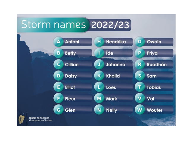
More information is available on our Storm names page
Weather Warnings for Northern Ireland
Weather Warnings for Northern Ireland
Met Éireann display current weather warnings for Northern Ireland. This is to provide a clear, authoritative one-stop shop for easy and reliable access to the latest weather warnings for the Island of Ireland. In particular it is hoped that this all-Ireland warnings display will promote citizen and societal safety in border regions.
Met Éireann do not issue weather warnings for Northern Ireland but rather display the Northern Ireland warnings which are issued by the UK Met Office www.metoffice.gov.uk in the United Kingdom.
Official weather warnings for each country are issued by the National Meteorological Service. Met Éireann issues warnings for Ireland (excluding Northern Ireland) and the Met Office in the UK issues warnings for Northern Ireland, Scotland, Wales and England.
An Orange warning is referred to as Amber for Northern Ireland as this is the colour coding used by the UK Met Office, as in Yellow/Amber/Red, as opposed to the labels Yellow/Orange/Red as used by Met Éireann.
Given our close geographical locations and frequently shared weather systems, Met Éireann and the UK Met Office have ongoing collaboration on the forecasting and naming of storms.
Environmental Warnings
BLIGHT WARNINGS
If a spell of mild and humid weather conditions is forecast to last long enough for potato blight spores to develop and subsequently spread to nearby plants a Blight Warning will be issued by the duty forecaster in Met Éireann.
A blight warning includes
- Areas affected
- Duration of the blight spell.
- A time for suitable spraying conditions prior to the blight spell should be indicated (ideally 48 hours ahead)
- Optimal spraying conditions are winds Force 3 or less (<11 kts), with little or no precipitation and trafficable soils.
- Blight Warnings issued during the first two weeks of May should include the specification ‘for early sown crops’
The blight forecasting method used in Ireland is based on the Bourke Rules, summarised as follows:
- Lead in Time (a lead in time is required before blight develops):
- A continuous 12 hour period with T>10°C and RH>90% and rainfall around the end of the 12 hour lead in time (±3 hrs)
OR
- A continuous 16 hour period with T>10°C and RH>90% and no rainfall.
- Effective Blight Hours (EBH):
- Effective Blight Hours are accumulated from the time the spores spread and begin after the Lead in Time is complete.
- They continue as long as conditions of T>10°C and RH>90% exist. The blight period will continue even if there are short gaps (<5 hrs) with cooler or drier conditions.
If 10 to >12 or more Effective Blight Hours are expected a BLIGHT WARNING is issued.
Fire Warnings - Drought Definitions
The Department of Agriculture, Food and the Marine issue fire warnings/fire danger notices based on fire weather data Courtesy of the European Commission Copernicus System, European Centre for Medium Range Weather Forecasting and Met Éireann. https://www.agriculture.gov.ie/forestservice/firemanagement/
DROUGHT DEFINITIONS
DRY SPELL: A dry spell is a period of 15 or more consecutive days to none of which is credited 1.0 mm or more of precipitation.
ABSOLUTE DROUGHT: An absolute drought is a period of 15 or more consecutive days to none of which is credited 0.2 mm or more of precipitation.
PARTIAL DROUGHT: A partial drought is a period of at least 29 consecutive days, the mean daily rainfall of which does not exceed 0.2 mm.
Be Summer Ready

Be Summer Ready 2022 booklet -click to open

Be Summer Ready 2022 leaflet
Be Winter Ready
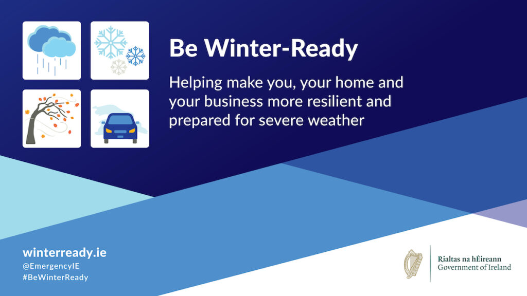
Be Winter Ready 2022 booklet
Be Winter Ready 2022 leaflet
Met Éireann Weather Warnings
Met Éireann Weather Warnings leaflet
Useful Knowledge - Impact Considerations
-

- Lightning strike
-

- Snow in Dublin City
-

- Flooding in Carrick on Shannon, Co. Leitrim
The timing and location of the occurrence of extreme weather can significantly affect the impact which it may have on society, or on the economy. In any individual weather event, not every location in the warning area may experience the same degree of weather or impacts. When severe weather is expected, weather and impacts at lower levels are also likely to be experienced. The type and amount of impacts can be strongly affected by previous weather conditions.
Precipitation
- Rainfall amounts can be up to double on windward upper slopes & impacts vary hugely depending on soil moisture deficits (small amounts of rain may cause flooding during a prolonged wet spell).
- Sudden heavy downpours can lead to flash flooding and poor visibility and can be accompanied by dangerous squally winds
- Heavy rain can turn to snow when temperatures are close to zero (up to around +4C)
- Thunderstorms: Be aware of the dangers of lightning and do not take shelter under an umbrella or a tree. It is dangerous to be out on open water. Be careful of landline phones or any metal that connects with the ground. Lightning can strike the same spot twice
Winds
- Winds can exceed general warning thresholds in exposed areas such as coasts and high ground and also in some low lying areas due to funneling effects
- Gusts of wind may produce some structural damage where structures have been weakened by an earlier storm and also damage to trees or even fell trees, even though the gust speeds are not particularly strong.
- Trees are more vulnerable to strong winds when in leaf
- High waves can occur on lakes as well as along coasts
- Beware of high sided vehicles in strong winds, particularly when overtaking. If you are driving a high sided vehicle try to anticipate exposed sections of roadway where winds will be stronger
Temperatures
- Hail showers can result in potentially lethal road conditions as the hail gets quickly compacted by traffic
- Ground temperatures can be as much as 10 degrees lower than air temperatures
- Fog/ice can persist all day in winter months
- Ice is not always visible on roads and surfaces
- High night-time temperatures in Summer, can be more impactful, especially on the vulnerable, than high daytime temperatures
Definition of key terms related to impact-based forecasting
Hazard
A hazard is defined as a hydro-meteorological, geophysical or human-induced element that poses a level of threat to life, property or the environment.
Impact
An impact describes the expected damage due to a hazard.
Exposure
Exposure refers to who and what may be affected in an area in which hazardous events may occur. If the population and economic resources were not located in (exposed to) potentially dangerous settings, no disaster risk would exist. Exposure is a necessary, but not sufficient, determinant of risk. It is possible to be exposed, but not vulnerable, for example, by living on a floodplain but having sufficient means to modify building structure and behaviour to mitigate potential loss. However, to be vulnerable to a hazard, it is also necessary to be exposed. Exposure is time (t) and space (x) dependent.
Vulnerability
Vulnerability refers to the susceptibility of exposed elements, such as human beings and their livelihoods and property, to suffer adverse effects when affected by a hazard. Vulnerability is related to predisposition, sensitivities, fragilities, weaknesses, deficiencies, or lack of capacities that favour adverse effects on the exposed elements. Vulnerability is situation specific, interacting with the hazard to generate risk. Therefore, vulnerability may also be time and space dependent. For example, as flood defences are built they protect the population in low-lying areas.
Risk
Risk = Probability of hazard event * consequences (vulnerabilities) * exposure. Risk is defined as the probability and magnitude of harm attendant on human beings and their livelihoods and assets because of their exposure and vulnerability to a hazard. The magnitude of harm may change due to response actions to either reduce exposure during the course of the event or reduce vulnerability to relevant hazard types in general.