June 2023 began with a blocking area of high pressure dominating just to the north of Ireland. This maintained a dry slack easterly airflow over the country for the first week of the month with almost unbroken sunshine. During the second week, as the high pressure system slowly pulled away to the north, a more unstable warm and humid air mass gradually encroached from the south and became established over the country. This brought more cloud as showers began to break out in a slack southerly airflow. Sea surface temperatures around our coasts were now well above average and continuing to rise, and this along with very weak steering currents, maintained the warm and humid air mass over the country. Low pressure to the southwest of Ireland introduced cool air aloft, which further destabilised the atmosphere, culminating in eight consecutive days of intense thunderstorm activity over Ireland between Tuesday 13th and Tuesday 20th. The final ten days of the month saw a westerly airflow take hold with Atlantic low pressure systems bringing frontal rain or showers at times, interspersed with dry periods. Another day of intense thunderstorms on Sunday 25th brought frequent lightning and hail in places. Mean temperatures stayed mostly above average during this period.
Rainfall: Below average in most places, dry first half, wetter second half
The majority of monthly rainfall totals across the country were below their 1981-2010 Long-Term Average (LTA). Percentage of monthly rainfall values ranged from 62% (monthly rainfall total of 50.3 mm) at Cork Airport to 139% (monthly rainfall total of 94.7 mm) at Ballyhaise, Co Cavan. Monthly rainfall totals ranged from 45.0 mm (72% of its LTA) at Casement Aerodrome, Co Dublin to 124.5 mm (131% of its LTA) at Valentia Observatory, Co Kerry. The highest daily rainfall total was 30.9 mm at Ballyhaise, Co Cavan on Tuesday 20th. The number of rain days ranged from 11 days at Moore Park, Co Cork to 19 days at a few stations. The number of wet days* ranged from 6 days at Johnstown Castle, Co Wexford to 18 days at Athenry, Co Galway (including 16 consecutive wet days* for Athenry from Thursday 15th to the end of the month). The number of very wet days* ranged from zero days at a few stations to 5 days at Valentia Observatory, Co Kerry. Most of the rainfall in June was convective in nature after Sunday 11th with eight consecutive days of intense thunderstorm activity between Tuesday 13th and Tuesday 20th and again on Sunday 25th. 24 stations had absolute droughts* between Monday 15th May and Sunday 11th June lasting between 17 and 26 days, longest in the South and East with Phoenix Park recording both its longest absolute drought* (26 days) and dry spell* (32 days). Malin Head, Co Donegal had a dry spell* between May 21st and June 16th lasting 27 days. Seven stations had partial droughts* between Thursday 11th May and Friday 16th June lasting between 29 and 36 days, longest in the South and East.
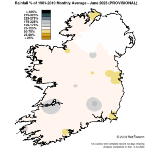
Rainfall % of 1981 – 2021 Monthly Average for June 2023 (Provisional)
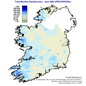
Total Monthly Rainfall (mm) for June 2023 (Provisional)
Temperature: Above average everywhere, warmest June on record at most stations
All mean air temperatures across the country were above their LTA for the month. Deviations from mean air temperature ranged from 1.9 °C (15.3 °C, 15.6 °C mean temperature) at Dublin Airport, Co Dublin and Johnstown Castle, Co Wexford respectively to 3.9 °C (16.2 °C mean temperature) at Knock Airport, Co Mayo. Mean temperatures for the month ranged from 15.1 °C (2.5 °C above its LTA) at Malin Head, Co Donegal to 17.5 °C (3.0 °C above its LTA) at Shannon Airport, Co Clare. The month’s highest temperature was reported at Oak Park, Co Carlow on Tuesday 13th with a temperature of 28.8 °C. Both the month’s lowest air and grass minimum temperature were recorded on Saturday 3rd at Mount Dillon, Co Roscommon. The lowest air minimum was 2.1 °C while the lowest grass minimum was -3.2 °C. There was no air frost reported this month. Less than half of stations reported ground frost. The number of days with ground frost ranged from zero days at most stations to 6 days at Mount Dillon, Co Roscommon. 23 stations had their warmest June on record (record lengths range from 12 to 83 years). Dublin Airport and Phoenix Park, Co Dublin had their warmest June since 1976. 11 stations had their highest minimum for June on record. 13 stations had their highest mean maximum and 19 stations had their highest mean minimum for June on record. Athenry, Co Galway and Shannon Airport, Co Clare experienced 27 consecutive days with maximum air temperatures > 20.0 °C, ending on Saturday 24 June.
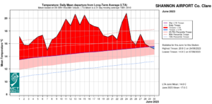
Shannon Airport, Co Clare Temperature: Daily mean departure from LTA for June 2023
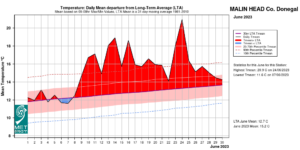
Malin Head, Co Donegal Temperature: Daily mean departure from LTA for June 2023
Sunshine: Above average, sunniest in the North
All available sunshine totals were above their LTA. Percentage of monthly sunshine values ranged from 139% (monthly sunshine total of 216.1 hours) at Shannon Airport, Co Clare to 142% (monthly sunshine total of 227.3 hours) at Casement Aerodrome, Co Dublin. Monthly sunshine totals ranged from 200.8 hours (No LTA comparison*) at Valentia Observatory, Co Kerry to 251.8 hours (No LTA comparison*) at Malin Head, Co Donegal. The highest number of daily sunshine hours recorded this month was 16.0 hours at Malin Head, Co Donegal on Friday 9th and Thursday 15th. The number of dull days2 ranged from 1 day at Casement Aerodrome, Co Dublin to 6 days at Belmullet, Co Mayo.
Wind: Not significantly strong
Monthly mean wind speeds ranged from 4.8 knots (8.9 km/h) at Ballyhaise, Co Cavan to 11.2 knots (20.7 km/h) at Mace Head, Co Galway. There were no days with gales, strong gales or storms reported this month. Both the month’s highest gust and 10-minute mean wind speed was reported at Belmullet, Co Mayo on Saturday 24th. The highest gust was 42 knots (78 km/h) while the month’s highest 10-minute mean wind speed was 32 knots (59 km/h).
The full report is available here
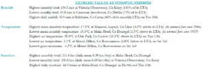
June 2023 extreme values at synoptic stations
Recent Junes in Ireland:
- 2016: Around two-thirds of Long-Term Average (LTA) rainfall values were above. All stations had above LTA mean air temperatures and a number of lightning strikes were detected, mainly in the North.
- 2017: Most stations had above-average monthly rainfall totals. All mean air temperatures were above. Two-thirds of sunshine totals were below and no significant winds or other elements were reported.
- 2018: All rainfall totals were below apart from Mount Dillon. Heatwave conditions were experienced with all monthly mean temperatures and sunshine totals above average. Storm Hector brought storm-force winds mid-month.
- 2019: The majority of monthly rainfall totals were above. Mean air temperatures across the country were below. Sunshine totals varied and no other significant elements were reported.
- 2020: The majority of monthly rainfall totals were above. Mean air temperatures were close to average everywhere in most places. Sunshine totals were below, and gales and some thunderstorms were experienced.
- 2021: All rainfall totals were below average. The majority of monthly mean air temperatures were above and nearly all sunshine totals were above.
- 2022: The majority of monthly rainfall totals were above. Mean air temperatures were mostly above average, and below average at some stations in the West. Sunshine totals varied and gales were reported.
*Issued by Met Éireann on Tuesday 4th July 2023. This report is based on available preliminary data from 25 principal weather stations operated by Met Éireann. Synoptic station data is midnight to midnight UTC. Long-Term Averages (LTAs) and “average” refer to the period 1981-2010. A wet day is a day with 1.0 mm or more of rainfall. A dull day is a day with less than 0.5 hours of sunshine. A very wet day is a day with 10.0 mm or more of rainfall. An absolute drought is a period of 15 or more consecutive days to none of which is credited 0.2 mm or more of precipitation. A partial drought is a period of at least 29 consecutive days, the mean daily rainfall of which does not exceed 0.2 mm. A dry spell is a period of 15 or more consecutive days to none of which is credited 1.0 mm or more of precipitation (i.e. daily tot < 1.0 mm). A heatwave occurs where there are 5 consecutive days or more with maximum temperature over 25°C (that is, a daily maximum screen air temperature > 25° C). *Sunshine data is from the Autosol Network. LTAs for these sites are currently not used for comparison purposes. For more information, contact Met Éireann at 01-8064200 or e-mail: enq@met.ie